Showing 829 items
matching subdivision plan
-
 Kew Historical Society Inc
Plan - Subdivision Plan, Summerhill Estate, 1920-1940
... Subdivision Plan... Summerhill Road. This subdivision plan is unusual in that the front... includes almost 100 subdivision plans pertaining to suburbs ...Pru Sanderson, in her groundbreaking ‘City of Kew Urban Conservation Study : Volume 2 - Development History’ (1988), summarised the periods of urban development and subdivisions of land in Kew. The periods that she identified included 1845-1880, 1880-1893, 1893-1921, 1921-1933, 1933-1943, and Post-War Development. These periods were selected as they represented periods of rapid growth or decline in urban development. An obvious starting point for Sanderson’s groupings involved population growth and the associated economic cycles. These cycles also highlighted urban expansion onto land that was predominantly rural, although in other cases it represented the decline and breakup of large estates. A number of the plans in the Kew Historical Society’s collection can also be found in other collections, such as those of the State Library of Victoria and the Boroondara Library Service. A number are however unique to the collection.The Kew Historical Society collection includes almost 100 subdivision plans pertaining to suburbs of the City of Melbourne. Most of these are of Kew, Kew East or Studley Park, although a smaller number are plans of Camberwell, Deepdene, Balwyn and Hawthorn. It is believed that the majority of the plans were gifted to the Society by persons connected with the real estate firm - J. R. Mathers and McMillan, 136 Cotham Road, Kew. The Plans in the collection are rarely in pristine form, being working plans on which the agent would write notes and record lots sold and the prices of these. The subdivision plans are historically significant examples of the growth of urban Melbourne from the beginning of the 20th Century up until the 1980s. A number of the plans are double-sided and often include a photograph on the reverse. A number of the latter are by noted photographers such as J.E. Barnes.The Summerhill Estate was a subdivision in Glen Iris of 24 ‘choice allotments’. The lots were primarily on both sides of Dillon Grove. Other lots at each end of the subdivision faced Margaret Street and Summerhill Road. It was from the latter that the subdivision took its advertised title. The lots were originally advertised for £10 deposit with 20 subsequent payments over five years. Pencilled on the printed plan is a change to the deposit required; a reduction to 20/-. Annotations indicate that the new deposits ranged from 30/- to 45/-. The most expensive lots faced Summerhill Road. This subdivision plan is unusual in that the front and rear of the card are for subdivisions in different localities.subdivision plans - glen iris, summerhill estate -
 Kew Historical Society Inc
Plan - Subdivision Plan, Old Kew Golf Links Estate - Third Section, 1920-1929
... Subdivision Plan...].The ‘Kew Conservation Study (1988) notes that ‘On the subdivision... includes almost 100 subdivision plans pertaining to suburbs ...Pru Sanderson, in her groundbreaking ‘City of Kew Urban Conservation Study : Volume 2 - Development History’ (1988), summarised the periods of urban development and subdivisions of land in Kew. The periods that she identified included 1845-1880, 1880-1893, 1893-1921, 1921-1933, 1933-1943, and Post-War Development. These periods were selected as they represented periods of rapid growth or decline in urban development. An obvious starting point for Sanderson’s groupings involved population growth and the associated economic cycles. These cycles also highlighted urban expansion onto land that was predominantly rural, although in other cases it represented the decline and breakup of large estates. A number of the plans in the Kew Historical Society’s collection can also be found in other collections, such as those of the State Library of Victoria and the Boroondara Library Service. A number are however unique to the collection.The Kew Historical Society collection includes almost 100 subdivision plans pertaining to suburbs of the City of Melbourne. Most of these are of Kew, Kew East or Studley Park, although a smaller number are plans of Camberwell, Deepdene, Balwyn and Hawthorn. It is believed that the majority of the plans were gifted to the Society by persons connected with the real estate firm - J. R. Mathers and McMillan, 136 Cotham Road, Kew. The Plans in the collection are rarely in pristine form, being working plans on which the agent would write notes and record lots sold and the prices of these. The subdivision plans are historically significant examples of the growth of urban Melbourne from the beginning of the 20th Century up until the 1980s. A number of the plans are double-sided and often include a photograph on the reverse. A number of the latter are by noted photographers such as J.E. Barnes.When the old Kew Golf Links was subdivided in the mid 1920s, the developers were able to break the sale into sections. The third section included eighty lots. The lots faced Kilby Road, Kodak Avenue, Belford Road, Baker Avenue, Mathers Avenue, and White Avenue. [Kodak Avenue was renamed Page Avenue at a later date].The ‘Kew Conservation Study (1988) notes that ‘On the subdivision plan, Kodak’s involvement is commemorated by the naming of the streets after Company directors, and their decision to not proceed with the construction of the factory is explained as a response to the increase in the value of the land. This explanation may have been Estate Agent’s hyperbole, as the Kodak Company records suggest that the land, with its wide creek gully, was unsuitable and too small for its purposes.subdivision plans - kew, old kew golf links estate - third section -
 Greensborough Historical Society
Planning document, City of Heidelberg, Subdivision Plan # G26. Grace Park Estate Greensborough, 1950c
... Subdivision Plan # G26. Grace Park Estate Greensborough....Plan of Subdivision (G26). Grace Park Estate. ... Plenty Lower Plenty melbourne Plan of Subdivision (G26). Grace ...Plan of Subdivision (G26). Grace Park Estate. An example of hard copy subdivision plans from the Greensborough area. From Shire of Heidelberg.Plan mounted on heavy card.Stamped and handwritten Council permissions, dates and other details.subdivision plans, grace park -
 Greensborough Historical Society
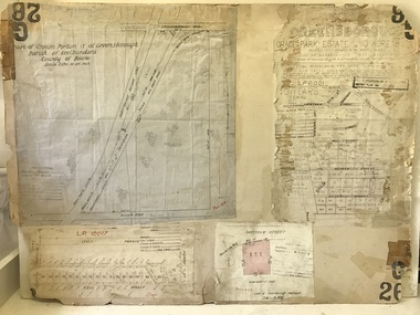
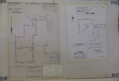
Poster - Planning Document, City of Heidelberg et al, Subdivision Plan # H 41 - Crown portion 8, Parish of Keelbundoora - Yallambie, and Crown Portion 9, Parish of Keelbundoora, 1922-1967
... Subdivision Plan # H 41 - Crown portion 8, Parish of...Planning Document: Subdivision Plan # H 41 Side 1, Crown...Planning Document: Subdivision Plan # H 41 Side 1, Crown ...Planning Document: Subdivision Plan # H 41 Side 1, Crown portion 8, Parish of Keelbundoora - Yallambie Road, Allima Avenue, Koolya Court, Ekam Court (Jennings Estate). Side 2: Crown Portion 9, Parish of Keelbundoora consist of 5 small subdivision sheets: 1. Somers Avenue, Stewart Terrace, Toubay Street and Railway Place (no date); 2. Somers Avenue, Maxwell Street, Greensborough Road, 1924; 3. Heidelberg Avenue, Golf Avenue, St Andrews Avenue (no date); 4. Birdwood Avenue, May Street (no date); 5. Strathallan Road 1924.An example of hard copy subdivision plans from the Greensborough area. Mainly from the Shire of Diamond Valley era (1964-1994).Plan (2 sided) mounted on heavy card. Stamped and handwritten Council permissions, dates and other details.subdivision plans, city of heidelberg, yallambie, macleod, greensborough -
 Greensborough Historical Society
Planning Document, John Taylor & Assoc, Subdivision Plan # 541, Somerleigh Crescent and Rainham Close, Greenhills, 21/06/1971
... Subdivision Plan # 541, Somerleigh Crescent and Rainham...Plan of Subdivision at Somerleigh Crescent and Rainham... Plenty Lower Plenty melbourne Plan of Subdivision at Somerleigh ...Plan of Subdivision at Somerleigh Crescent and Rainham Close, Greenhills.An example of hard copy subdivision plans from the Greensborough area. Mainly from the Shire of Diamond Valley era (1964-1994).Plan (2 sheets) mounted on heavy card.Stamped and handwritten Council permissions, dates and other details.subdivision plans, somerleigh crescent greensborough, rainham close greensborough -
 Greensborough Historical Society
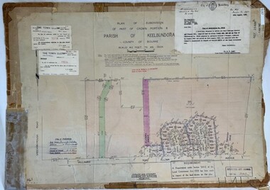
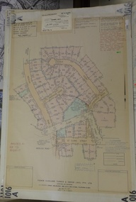
Poster - Planning Document, City of Heidelberg, Subdivision Plan # G313, Corner Main and Grimshaw Streets, Greensborough, 08/03/1960
... Subdivision Plan # G313, Corner Main and Grimshaw Streets...Plan of Subdivision at corner of Main and Grimshaw Streets...Plan of Subdivision at corner of Main and Grimshaw Streets ...Plan of Subdivision at corner of Main and Grimshaw Streets, Greensborough.An example of hard copy subdivision plans from the Greensborough area. Mainly from the Shire of Diamond Valley era (1964-1994).Plan (2 sheets) mounted on heavy card.Stamped and handwritten Council permissions, dates and other details.subdivision plans, main street greensborough, grimshaw street greensborough -
 Greensborough Historical Society
Planning document, Subdivision Plan #1128. St Helena Road Greensborough, 1985_
... Subdivision Plan #1128. St Helena Road Greensborough....Plan of Subdivision for property at St Helena Road... Plenty Lower Plenty melbourne Plan of Subdivision for property ...Plan of Subdivision for property at St Helena Road. (superseded plan)An example of hard copy subdivision plans from the Greensborough area. Mainly from the Shire of Diamond Valley era (1964-1994).Plan (2 sheets) mounted on heavy card.Stamped and handwritten Council permissions, dates and other details. Notation: 'Superseded plan see G1190'subdivision plans, st helena road -
 Kew Historical Society Inc
Plan - Subdivision Plan, Wimba Estate, Kew, c.1925-c.1929, ca. 1925-ca. 1929
... Subdivision Plan... described in the subdivision plan as the ‘Wimba Estate’. These lots... unique to the collection. Subdivision plans are historically ...Pru Sanderson, in her groundbreaking ‘City of Kew Urban Conservation Study : Volume 2 - Development History’ (1988), summarised the periods of urban development and subdivisions of land in Kew. The periods that she identified included 1845-1880, 1880-1893, 1893-1921, 1921-1933, 1933-1943, and Post-War Development. These periods were selected as they represented periods of rapid growth or decline in urban development. An obvious starting point for Sanderson’s groupings involved population growth and the associated economic cycles. These cycles also highlighted urban expansion onto land that was predominantly rural, although in other cases it represented the decline and breakup of large estates. A number of the plans in the Kew Historical Society’s collection can also be found in other collections, such as those of the State Library of Victoria and the Boroondara Library Service. A number are however unique to the collection.Subdivision plans are historically important documents used as evidence of the growth of suburbs in Australia. They frequently provide information about when the land was sold on which a built structure was subsequently constructed as well as evidence relating to surveyors and real estate and financial agents. The numerous subdivision plans in the Kew Historical Society's collection represent working documents, ranging from the initial sketches made in planning a subdivision to printed plans on which auctioneers or agents listed the prices for which individual lots were sold. In a number of cases, the reverse of a subdivision plan in the collection includes a photograph of a house that was also for sale by the agent. These photographs provide significant heritage information relating house design and decoration, fencing and household gardens.In 1925, the City of Kew called for tenders for the construction of Wimba Avenue, Cadow Street and Lalla Street. Subsequent advertisements for the sale of land in Wimba Avenue continued from 1926 to 1929. The 18 lots (and a further five allotments on the eastern side of the street) offered for sale were unofficially described in the subdivision plan as the ‘Wimba Estate’. These lots began in Park Hill Road and extended almost to Cotham Road. The subdivision took its name from the house ‘Wimba’ in Cotham Road, which may have formed the southern boundary of the subdivision. (Wimba, at 235 Cotham Road was constructed between 1862-70). The Plan highlights the proximity and advantage of ‘electric’ trams in Cotham and Glenferrie Roads, and the Kew and Glenferrie Railway Stations. An oddity in the Plan is the reference to the electric tram terminus at Burke Road, given that the tramline had already been extended to Mont Albert in 1916.wimba estate, subdivision plans - kew, parkhill road – kew (vic.), normanby road – kew (vic.), wimba avenue – kew (vic.) -
 Greensborough Historical Society
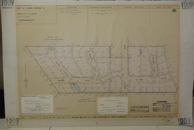
Planning document, Subdivision Plan #1009. Corner Allumba Drive and Beales Road Greensborough, 1981_
... Subdivision Plan #1009. Corner Allumba Drive and Beales...Plan of Subdivision of land at corner of Allumba Drive... Plenty Lower Plenty melbourne Plan of Subdivision of land ...Plan of Subdivision of land at corner of Allumba Drive and Beales Road Greensborough.An example of hard copy subdivision plans from the Greensborough area. Mainly from the Shire of Diamond Valley era (1964-1994).Plan (2 sheets) mounted on heavy card.Stamped and handwritten Council permissions, dates and other details.subdivision plans, allumba drive, beales road -
 Greensborough Historical Society
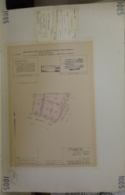
Planning document, Subdivision Plan #1005. Corner Douglas Court and Glen Katherine Drive Greensborough, 1981_
... Subdivision Plan #1005. Corner Douglas Court and Glen...Plan of Subdivision. Corner Douglas Court and Glen... Plenty Lower Plenty melbourne Plan of Subdivision. Corner Douglas ...Plan of Subdivision. Corner Douglas Court and Glen Katherine Drive Greensborough.An example of hard copy subdivision plans from the Greensborough area. Mainly from the Shire of Diamond Valley era (1964-1994).Plan (2 sheets) mounted on heavy card.Stamped and handwritten Council permissions, dates and other details.subdivision plans, douglas court, glen katherine drive -
 Greensborough Historical Society
Planning Document, Subdivision Plan # 1016. Corner Weidlich and St Clems Roads Greensborough, 05/10/1981
... Subdivision Plan # 1016. Corner Weidlich and St Clems Roads...Plan of Subdivision of land at corner of Weidlich Road... Plenty Lower Plenty melbourne Plan of Subdivision of land ...Plan of Subdivision of land at corner of Weidlich Road and St Clems Road Greensborough.Plan (2 sheets) mounted on heavy card.Stamped and handwritten Council permissions, dates and other details.subdivision plans, weidlich road -
 Kew Historical Society Inc
Plan - Subdivision Plan, Oswinia Estate, East Kew, c.1925
... Subdivision Plan...The ‘Oswinia Estate’ subdivision in East Kew was planned... unique to the collection. Subdivision plans are historically ...Prue Sanderson, in her groundbreaking ‘City of Kew Urban Conservation Study : Volume 2 - Development History’ (1988), summarised the periods of urban development and subdivisions of land in Kew. The periods that she identified included 1845-1880, 1880-1893, 1893-1921, 1921-1933, 1933-1943, and Post-War Development. These periods were selected as they represented periods of rapid growth or decline in urban development. An obvious starting point for Sanderson’s groupings involved population growth and the associated economic cycles. These cycles also highlighted urban expansion onto land that was predominantly rural, although in other cases it represented the decline and breakup of large estates. A number of the plans in the Kew Historical Society’s collection can also be found in other collections, such as those of the State Library of Victoria and the Boroondara Library Service. A number are however unique to the collection.Subdivision plans are historically important documents used as evidence of the growth of suburbs in Australia. They frequently provide information about when the land was sold on which a built structure was subsequently constructed as well as evidence relating to surveyors and real estate and financial agents. The numerous subdivision plans in the Kew Historical Society's collection represent working documents, ranging from the initial sketches made in planning a subdivision to printed plans on which auctioneers or agents listed the prices for which individual lots were sold. In a number of cases, the reverse of a subdivision plan in the collection includes a photograph of a house that was also for sale by the agent. These photographs provide significant heritage information relating house design and decoration, fencing and household gardens.The ‘Oswinia Estate’ subdivision in East Kew was planned and auctioned in the first half of the 1920s. 169 allotments were created in the triangular section of land bordered by High Street, Burke Road and the Government Boulevard (later Kilby Road). The only piece of land excluded was that where the previous Kew Pound had been located at the east tip of the triangle. Allotments were created fronting Glass, High, Namur, Oswin Streets, Irymple Avenue, and the Government Boulevard. The name for the Estate was derived from Oswin’s farm, which had been one of the largest landholdings in East Kew. The selling agents annotated the plan in our collection with crosses indicating those lots that had been sold. The inset locality plan is particularly interesting as it shows the route and stations of the Outer Circle Railway. When the subdivision plan was created, it included the proposed bridge over the Yarra at Burke Road. The bridge was to be officially opened in 1926.subdivision plans - east kew, oswinia estate, high street, glass street, namur street, government boulevard - kilby road, irymple street, oswin street -
 Kew Historical Society Inc
Plan - Subdivision Plan, J R Mathers & McMillan, Clutha Subdivision, 1940
... Subdivision Plan...The subdivision plan for the Clutha Subdivision is one... includes almost 100 subdivision plans pertaining to suburbs ...Pru Sanderson, in her groundbreaking ‘City of Kew Urban Conservation Study : Volume 2 - Development History’ (1988), summarised the periods of urban development and subdivisions of land in Kew. The periods that she identified included 1845-1880, 1880-1893, 1893-1921, 1921-1933, 1933-1943, and Post-War Development. These periods were selected as they represented periods of rapid growth or decline in urban development. An obvious starting point for Sanderson’s groupings involved population growth and the associated economic cycles. These cycles also highlighted urban expansion onto land that was predominantly rural, although in other cases it represented the decline and breakup of large estates. A number of the plans in the Kew Historical Society’s collection can also be found in other collections, such as those of the State Library of Victoria and the Boroondara Library Service. A number are however unique to the collection.The Kew Historical Society collection includes almost 100 subdivision plans pertaining to suburbs of the City of Melbourne. Most of these are of Kew, Kew East or Studley Park, although a smaller number are plans of Camberwell, Deepdene, Balwyn and Hawthorn. It is believed that the majority of the plans were gifted to the Society by persons connected with the real estate firm - J. R. Mathers and McMillan, 136 Cotham Road, Kew. The Plans in the collection are rarely in pristine form, being working plans on which the agent would write notes and record lots sold and the prices of these. The subdivision plans are historically significant examples of the growth of urban Melbourne from the beginning of the 20th Century up until the 1980s. A number of the plans are double-sided and often include a photograph on the reverse. A number of the latter are by noted photographers such as J.E. Barnes.The subdivision plan for the Clutha Subdivision is one of the largest in the Society’s collection. The plan includes a map of the proposed allotments, photographic views to the north and south, and information about the kinds of buildings that could be constructed on the allotments. The subdivision was bounded by Studley Park Road, and Carson, Stevenson and Edgecombe Streets. Two new streets, Mackie Court and Younger Street were created as part of the subdivision. The subdivision took its name from ‘Clutha’, the home of John Carson, who was to become Mayor of Kew in 1863. A Report to the City of Boroondara outlined how: ‘The Clutha estate was progressively developed from 1940, with new houses under construction on the Studley Park Road, Carson and Edgecombe Street frontages by 1941. By 1943, directory listings were available for all addresses with the exception of Mackie Court. Building ceased after the government’s prohibition on civilian building was enforced from 1942, with little change in listings until the 1950s when the remainder of the subdivision was developed’."H"subdivisions - kew - studley park, clutha subdivision, studley park road -
 Greensborough Historical Society
Planning Document, Subdivision Plan #1041. Elder Street Greensborough, 20/04/1983
... Subdivision Plan #1041. Elder Street Greensborough . ... and Plan of Subdivision for Elder Street. ... 3 and 4 Brixton Avenue and Plan of Subdivision for Elder ...Plan of Consolidation of Allotments 3 and 4 Brixton Avenue and Plan of Subdivision for Elder Street. An example of hard copy subdivision plans from the Greensborough area. Mainly from the Shire of Diamond Valley era (1964-1994).Plan (2 sheets) mounted on heavy card.Stamped and handwritten Council permissions, dates and other details.subdivision plans, elder street, brixton avenue -
 Greensborough Historical Society
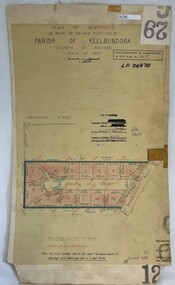
Poster - Planning Document, City of Heidelberg, Subdivision Plan # G 29 Part 2, Crown portion 16, Greensborough, 1951
... Subdivision Plan # G 29 Part 2, Crown portion 16...Plan of Subdivisions in City of Heidelberg: Parish...Plan of Subdivisions in City of Heidelberg: Parish ...Plan of Subdivisions in City of Heidelberg: Parish of Keelbundoora: Crown portion 16 - Daours Court and Devonshire Road, 1951.An example of hard copy subdivision plans from the Greensborough area. Mainly from the Shire of Diamond Valley era (1964-1994).Plan (single sided) mounted on heavy card. Stamped and handwritten Council permissions, dates and other details.subdivision plans, city of heidelberg -
 Greensborough Historical Society
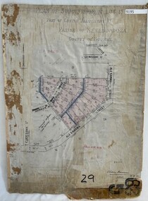
Poster - Planning Document, City of Heidelberg, Subdivision Plan # G 29 Part 1, Crown allotment 17, Greensborough, 1922
... Subdivision Plan # G 29 Part 1, Crown allotment 17...Plan of Subdivisions in City of Heidelberg: Parish...Plan of Subdivisions in City of Heidelberg: Parish ...Plan of Subdivisions in City of Heidelberg: Parish of Keelbundoora: Crown allotment 17 - Warwick Road, Clydbank Street, Alexandra Street, 1922.An example of hard copy subdivision plans from the Greensborough area. Mainly from the Shire of Diamond Valley era (1964-1994).Plan (single sided) mounted on heavy card. Stamped and handwritten Council permissions, dates and other details.subdivision plans, city of heidelberg -
 Kew Historical Society Inc
Plan - Subdivision Plan, Violet Farm Estate, 1927
... Subdivision Plan...A subdivision plan for nineteen ‘bonny, airy building... includes almost 100 subdivision plans pertaining to suburbs ...Pru Sanderson, in her groundbreaking ‘City of Kew Urban Conservation Study : Volume 2 - Development History’ (1988), summarised the periods of urban development and subdivisions of land in Kew. The periods that she identified included 1845-1880, 1880-1893, 1893-1921, 1921-1933, 1933-1943, and Post-War Development. These periods were selected as they represented periods of rapid growth or decline in urban development. An obvious starting point for Sanderson’s groupings involved population growth and the associated economic cycles. These cycles also highlighted urban expansion onto land that was predominantly rural, although in other cases it represented the decline and breakup of large estates. A number of the plans in the Kew Historical Society’s collection can also be found in other collections, such as those of the State Library of Victoria and the Boroondara Library Service. A number are however unique to the collection.The Kew Historical Society collection includes almost 100 subdivision plans pertaining to suburbs of the City of Melbourne. Most of these are of Kew, Kew East or Studley Park, although a smaller number are plans of Camberwell, Deepdene, Balwyn and Hawthorn. It is believed that the majority of the plans were gifted to the Society by persons connected with the real estate firm - J. R. Mathers and McMillan, 136 Cotham Road, Kew. The Plans in the collection are rarely in pristine form, being working plans on which the agent would write notes and record lots sold and the prices of these.The subdivision plans are historically significant examples of the growth of urban Melbourne from the beginning of the 20th Century up until the 1980s. A number of the plans are double-sided and often include a photograph on the reverse. A subdivision plan for nineteen ‘bonny, airy building blocks’ on either side of Violet Grove, Kew East. Violet Grove runs between High Street and Harp Road. Like many other subdivisions in Kew and East Kew, older houses (Lots 1 and 13) were often included in the subdivision. Such houses were in some instances the original properties that were subdivided, or in the case of the Violet Grove subdivision, new houses such as the weatherboard villa on lot 13. This villa is advertised as having a tiled roof, 5 rooms, panelled hall, double doors (Rooms 14 x 12 ft. 6 in. (2) 14 x 12, 12 x 11, 13 x 11). A bricked front verandah, a tiled stove recess and existing sewerage connection added to its saleable potential. Water, electric light and power, and gas were all offered as part of the deal. Violet Grove now has about 35 houses, which indicates that the 19 lots of the subdivision were to be further subdivided by purchasers. [A similar plan is in the Batten & Percy Collection of the State Library of Victoria.]subdivision plans - east kew, violet farm estate, violet grove -- kew (vic.), boorool road -- kew (vic.), harp road -- kew east (vic.) -
 Greensborough Historical Society
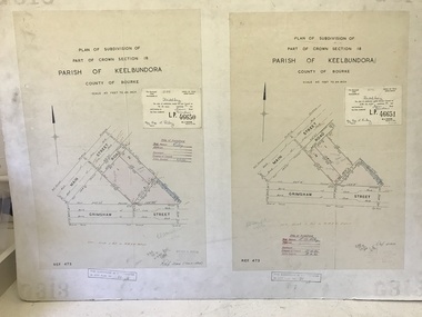
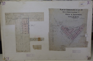
Planning Document, Subdivision Plan # 37. Poulter Avenue and Bicton Street; and, Adeline Street and Grimshaw Street Greensborough, 1971_
... Subdivision Plan # 37. Poulter Avenue and Bicton Street...Plan of subdivision Lot 29, Part of Crown Allotment, Parish... Plenty Lower Plenty melbourne Plan of subdivision Lot 29, Part ...Plan of subdivision Lot 29, Part of Crown Allotment, Parish of Keelbundoora, County of Bourke. Poulter Avenue and Bicton Street; and, Adeline Street and Grimshaw Street.An example of hard copy subdivision plans from the Greensborough area. Mainly from the Shire of Diamond Valley era (1964-1994).Plan (2 sheets) mounted on heavy card. subdivision plans, grimshaw street, poulter avenue, adeline street -
 Greensborough Historical Society
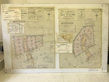
Poster - Planning Document, Shire of Diamond Valley, Subdivision Plan # G 1, Watsonia, 1962 and 1976
... Subdivision Plan # G 1, Watsonia...Plan of Subdivisions in Shire of Diamond Valley: Side 1...Plan of Subdivisions in Shire of Diamond Valley: Side 1 ...Plan of Subdivisions in Shire of Diamond Valley: Side 1: subdivision of LP5406 bounded by Plenty Road, Greensborough Road, Meakin Avenue, Watsonia and includes Aqueduct Road, 1976. Side 2: 2 plans - Keelbundoora: Morwell Avenue and Grace Street; Nillumbik: Inglis Street and Chute Street Diamond Creek, 1962An example of hard copy subdivision plans from the Greensborough area. Mainly from the Shire of Diamond Valley era (1964-1994).Plan (2 sided) mounted on heavy card. Contains 2 sheets pasted together.Stamped and handwritten Council permissions, dates and other details. subdivision plans, diamond creek, shire of diamond valley -
 Greensborough Historical Society
Poster - Planning Document, City of Heidelberg, Subdivision Plan # G 27, Greensborough and Diamond Creek, 1922 and 1963
... Subdivision Plan # G 27, Greensborough and Diamond Creek...Plan of Subdivisions in City of Heidelberg: Side 1: 2 plans...Plan of Subdivisions in City of Heidelberg: Side 1: 2 plans ...Plan of Subdivisions in City of Heidelberg: Side 1: 2 plans, Parish of Keelbundoora: plan 1: Henry Street, Vermont Avenue, Lyell Street, Nell Street, McDowell Street, 1922. Plan 2: Henry Street, Nepean Street, Charles Street, 1922. Side 2: 2 plans Parish of Nillumbik, Portion 13: Plan 1: Diamond Creek Road, Delfin Crescent, Ridge Road, 1963. Plan 2: Kinglake Road, Eltham Road, 1963.An example of hard copy subdivision plans from the Greensborough area. Mainly from the Shire of Diamond Valley era (1964-1994).Plan (2 sided) mounted on heavy card. Contains 2 sheets pasted together.Stamped and handwritten Council permissions, dates and other details.subdivision plans, city of heidelberg -
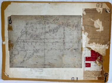
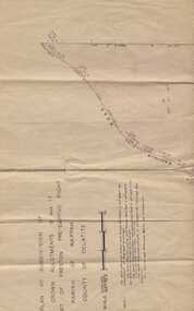
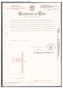 Ringwood and District Historical Society
Document, Certificate of Title 1977 and Subdivision Plan 1999 - 21-23 Bemboka Road Warranwood, Victoria
... Certificate of Title 1977 and Subdivision Plan 1999 - 21-23... Plan of Subdivision , postal address Bemboka Road, Warranwood... Plan of Subdivision , postal address Bemboka Road, Warranwood ...A4 copies of Landata Victoria Historical Search documents. Certificate of Title Vol 9217 Fol 041 Church of England Trusts Corporation For The Diocese Of Melbourne - part of Crown Section 20, Parish of Warrandyte, County of Evelyn, 7th June, 1977. Includes Plan of Subdivision , postal address Bemboka Road, Warranwood 3134 (north of Lyric Court), certified under Subdivision Act 1988, 8/2/1999. -
 Warrnambool and District Historical Society Inc.
Subdivision plan, Part of Preston Estate Parish of Wappan
... Subdivision plan...Plan of subdivision of part of crown allotments 15 and 17... in pink. Part of Preston Estate Parish of Wappan. Subdivision plan ...This map possibly relates to land of John Bostock at Preston, Delatite. Part of a collection of papers relating to the Bostock family one of the earliest pioneering families in Warrnambool.Cream coloured map printed in black with sections coloured in pink. Plan of subdivision of part of crown allotments 15 and 17 and part of Preston pre- emptive right, Parish of Wappan, County of Delatite.warrnambool,bostock,augustus bostock map, delatite map,district of wappan map, -
 Kew Historical Society Inc
Plan - Subdivision Plan, H C Crouch, Old Golf Links Estate, 1930s
... Subdivision Plan... years in the early 1930s. Subdivision plans are historically ...The land in North Kew between the Outer Circle Railway and the River Yarra was released in sections. This release included 80 lots. Most of this area was released during the Depression years in the early 1930s.Subdivision plans are historically important documents used as evidence of the growth of suburbs in Australia. They frequently provide information about when the land was sold on which a built structure was subsequently constructed as well as evidence relating to surveyors and real estate and financial agents. The numerous subdivision plans in the Kew Historical Society's collection represent working documents, ranging from the initial sketches made in planning a subdivision to printed plans on which auctioneers or agents listed the prices for which individual lots were sold. In a number of cases, the reverse of a subdivision plan in the collection includes a photograph of a house that was also for sale by the agent. These photographs provide significant heritage information relating house design and decoration, fencing and household gardens.One part of a massive subdivision of the Old Golf Links Estate in North Kew of 80 allotments bordering Sutherland Avenue, Ramsay Avenue, Belford Road, Beresford Street and Coleman Avenue. Inset on the plan at the top left, the route of the Outer Circle Railway is clearly marked. The Kew Golf Links is identified in its current location. The land on which Greenacres Golf Club was to be constructed is at this time marked as ‘Recreation Ground’. The ‘new bridge’ over the Yarra at Burke Road is also marked on the inset map. The Plan identifies the surveyor (sic) H.C. Crouch BCE MVIS, 443 Little Collins St., Melbourne. The date of the subdivision auction sale in identified as Saturday September 25th at three o'clock.Annotations: "E" top left. "Golf Links" top right. Lots 73-76 ticked and listed as "6" poundssubdivisions -- kew (vic.), old golf links estate -
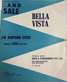 Kew Historical Society Inc
Plan - Subdivision Plan, Bella Vista, Doncaster East
... Subdivision Plan... East, subdivision plans - doncaster east (vic) bella vista ...The Bella Vista Subdivision included 101 lots in Murphy Road, Kerry Close, Keir Avenue, Norman Street, Daphne Street in Doncaster East,An undated, four-page colour brochure for the sale of the Bella Vista Estate in Doncaster East. The item includes a separate price list of the home sites maintained by the agent. The latter includes the original and the discounted price. subdivision plans - doncaster east (vic), bella vista subdivision - doncaster east (vic) -
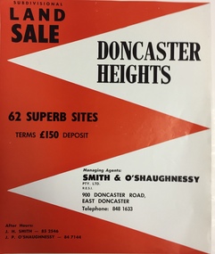 Kew Historical Society Inc
Plan - Subdivision Plan, Doncaster Heights
... Subdivision Plan... plan subdivision plans - doncaster doncaster heights estate ...Real estate brochure produced for Smith & O'Shaughnessy of 900 Doncaster Road for the sale of the '65 superb sites' in the Doncaster Heights Estate. Streets with lots for sale include: Church Road, Norfolk Circuit, and Hampshire Road.Historic subdivision planFour-page colour real estate brochure issued for the sale of the Doncaster Heights Estate. The inside pages include a street plan with the numbered lots.subdivision plans - doncaster, doncaster heights estate -
 Kew Historical Society Inc
Plan - Subdivision Plan, Altyre Estate, 1920, 1920
... Subdivision Plan... includes almost 100 subdivision plans pertaining to suburbs ...Pru Sanderson, in her groundbreaking ‘City of Kew Urban Conservation Study : Volume 2 - Development History’ (1988), summarised the periods of urban development and subdivisions of land in Kew. The periods that she identified included 1845-1880, 1880-1893, 1893-1921, 1921-1933, 1933-1943, and Post-War Development. These periods were selected as they represented periods of rapid growth or decline in urban development. An obvious starting point for Sanderson’s groupings involved population growth and the associated economic cycles. These cycles also highlighted urban expansion onto land that was predominantly rural, although in other cases it represented the decline and breakup of large estates. A number of the plans in the Kew Historical Society’s collection can also be found in other collections, such as those of the State Library of Victoria and the Boroondara Library Service. A number are however unique to the collection.The Kew Historical Society collection includes almost 100 subdivision plans pertaining to suburbs of the City of Melbourne. Most of these are of Kew, Kew East or Studley Park, although a smaller number are plans of Camberwell, Deepdene, Balwyn and Hawthorn. It is believed that the majority of the plans were gifted to the Society by persons connected with the real estate firm - J. R. Mathers and McMillan, 136 Cotham Road, Kew. The Plans in the collection are rarely in pristine form, being working plans on which the agent would write notes and record lots sold and the prices of these. The subdivision plans are historically significant examples of the growth of urban Melbourne from the beginning of the 20th Century up until the 1980s. A number of the plans are double-sided and often include a photograph on the reverse. A number of the latter are by noted photographers such as J.E. Barnes.The Altyre Estate was advertised for sale by auction in 1920. A colour lithograph in the State Library of Victoria, in contrast to this monochrome version, notes the proximity of the subdivision to the Auburn Heights Bowling Club and to a range of transport options. The subdivision included fifty-one allotments as well as the original house ‘Altyre’ in Barkers Road. This version includes the amounts paid as deposit on a number of lots.subdivision plans - kew, altyre estate – kew (vic), barkers road – kew (vic), walsh street – kew (vic), ross street – kew (vic), loxton street – kew (vic), mount street – kew (vic), auburn heights bowling club, altyre -
 Kew Historical Society Inc
Plan - Subdivision Plan, Birdwood Estate, 1920
... Subdivision Plan... includes almost 100 subdivision plans pertaining to suburbs ...Pru Sanderson, in her groundbreaking ‘City of Kew Urban Conservation Study : Volume 2 - Development History’ (1988), summarised the periods of urban development and subdivisions of land in Kew. The periods that she identified included 1845-1880, 1880-1893, 1893-1921, 1921-1933, 1933-1943, and Post-War Development. These periods were selected as they represented periods of rapid growth or decline in urban development. An obvious starting point for Sanderson’s groupings involved population growth and the associated economic cycles. These cycles also highlighted urban expansion onto land that was predominantly rural, although in other cases it represented the decline and breakup of large estates. A number of the plans in the Kew Historical Society’s collection can also be found in other collections, such as those of the State Library of Victoria and the Boroondara Library Service. A number are however unique to the collection.The Kew Historical Society collection includes almost 100 subdivision plans pertaining to suburbs of the City of Melbourne. Most of these are of Kew, Kew East or Studley Park, although a smaller number are plans of Camberwell, Deepdene, Balwyn and Hawthorn. It is believed that the majority of the plans were gifted to the Society by persons connected with the real estate firm - J. R. Mathers and McMillan, 136 Cotham Road, Kew. The Plans in the collection are rarely in pristine form, being working plans on which the agent would write notes and record lots sold and the prices of these. The subdivision plans are historically significant examples of the growth of urban Melbourne from the beginning of the 20th Century up until the 1980s. A number of the plans are double-sided and often include a photograph on the reverse. A number of the latter are by noted photographers such as J.E. Barnes.Bordering Burke Road, the Birdwood Estate included a subdivision of 34 lots on either side of Birdwood Street, Balwyn. Six of the lots faced Burke Road. At the other end of the subdivision a line would indicate that a creek once bordered the subdivision. Lots were advertised for sale at a low figure on five-year terms. Purchasers could pay off the balance in twenty quarterly instalments (i.e. over five years).subdivision plans - balwyn, birdwood estate -
 Kew Historical Society Inc
Plan - Subdivision Plan, Mayfield Estate, 1927
... Subdivision Plan... subdivision plans pertaining to suburbs of the City of Melbourne. Most ...A number of the plans in the Kew Historical Society’s collection can also be found in other collections, such as those of the State Library of Victoria. A number are however unique to the collection.The Kew Historical Society collection includes almost 100 subdivision plans pertaining to suburbs of the City of Melbourne. Most of these are of Kew, Kew East or Studley Park, although a smaller number are plans of Camberwell, Deepdene, Balwyn and Hawthorn. It is believed that the majority of the plans were gifted to the Society by persons connected with the real estate firm - J. R. Mathers and McMillan, 136 Cotham Road, Kew. The Plans in the collection are rarely in pristine form, being working plans on which the agent would write notes and record lots sold and the prices of these. The subdivision plans are historically significant examples of the growth of urban Melbourne from the beginning of the 20th Century up until the 1980s. A number of the plans are double-sided and often include a photograph on the reverse. A number of the latter are by noted photographers such as J.E. Barnes.The Mayfield Estate subdivision included 14 allotments surrounding Evan Court (now Evans Court) in Toorak. The subdivision adjoined Toorak Road east of Kooyong Road and alerted prospective buyers to how the Toorak Road tram would take them directly to the city. This emphasis on existing transport routes was a feature of subdivisions during a period when car ownership was the preserve of the wealthy. An existing brick villa (‘Mayfield’) is noted as already constructed on lot 13. The subdivision also notes that the lots adjoin land owned by Sir Edward Miller. Today Evans Court extends beyond this subdivision through to Moonga Road.subdivision plans - toorak, mayfield estate, sir edward miller -
 Kew Historical Society Inc
Plan - Subdivision Plan, Cotham Vale Estate, 1919
... Subdivision Plan... includes almost 100 subdivision plans pertaining to suburbs ...Pru Sanderson, in her groundbreaking ‘City of Kew Urban Conservation Study : Volume 2 - Development History’ (1988), summarised the periods of urban development and subdivisions of land in Kew. The periods that she identified included 1845-1880, 1880-1893, 1893-1921, 1921-1933, 1933-1943, and Post-War Development. These periods were selected as they represented periods of rapid growth or decline in urban development. An obvious starting point for Sanderson’s groupings involved population growth and the associated economic cycles. These cycles also highlighted urban expansion onto land that was predominantly rural, although in other cases it represented the decline and breakup of large estates. A number of the plans in the Kew Historical Society’s collection can also be found in other collections, such as those of the State Library of Victoria and the Boroondara Library Service. A number are however unique to the collection.The Kew Historical Society collection includes almost 100 subdivision plans pertaining to suburbs of the City of Melbourne. Most of these are of Kew, Kew East or Studley Park, although a smaller number are plans of Camberwell, Deepdene, Balwyn and Hawthorn. It is believed that the majority of the plans were gifted to the Society by persons connected with the real estate firm - J. R. Mathers and McMillan, 136 Cotham Road, Kew. The Plans in the collection are rarely in pristine form, being working plans on which the agent would write notes and record lots sold and the prices of these. The subdivision plans are historically significant examples of the growth of urban Melbourne from the beginning of the 20th Century up until the 1980s. A number of the plans are double-sided and often include a photograph on the reverse. A number of the latter are by noted photographers such as J.E. Barnes.The Cotham Vale Estate was a subdivision of land between Alfred, Thomas, Rowland and John Streets. It was promoted in the same time as the nearby Normanby Heights Estate. Cotham Vale included 28 allotments. Contemporary newspaper advertisements noted that the Estate ‘is most conveniently situated in a well elevated position, only 2 minutes from Cotham rd. Electric Cars, penny section to Kew station’.subdivision plans - kew, cotham vale estate, rowland street -- kew (vic.), thomas street -- kew (vic.), john street -- kew (vic.) -
 Kew Historical Society Inc
Plan - Subdivision Plan, Golf View Estate, c.1922
... Subdivision Plan... includes almost 100 subdivision plans pertaining to suburbs ...Pru Sanderson, in her groundbreaking ‘City of Kew Urban Conservation Study : Volume 2 - Development History’ (1988), summarised the periods of urban development and subdivisions of land in Kew. The periods that she identified included 1845-1880, 1880-1893, 1893-1921, 1921-1933, 1933-1943, and Post-War Development. These periods were selected as they represented periods of rapid growth or decline in urban development. An obvious starting point for Sanderson’s groupings involved population growth and the associated economic cycles. These cycles also highlighted urban expansion onto land that was predominantly rural, although in other cases it represented the decline and breakup of large estates. A number of the plans in the Kew Historical Society’s collection can also be found in other collections, such as those of the State Library of Victoria and the Boroondara Library Service. A number are however unique to the collection.The Kew Historical Society collection includes almost 100 subdivision plans pertaining to suburbs of the City of Melbourne. Most of these are of Kew, Kew East or Studley Park, although a smaller number are plans of Camberwell, Deepdene, Balwyn and Hawthorn. It is believed that the majority of the plans were gifted to the Society by persons connected with the real estate firm - J. R. Mathers and McMillan, 136 Cotham Road, Kew. The Plans in the collection are rarely in pristine form, being working plans on which the agent would write notes and record lots sold and the prices of these. The subdivision plans are historically significant examples of the growth of urban Melbourne from the beginning of the 20th Century up until the 1980s. A number of the plans are double-sided and often include a photograph on the reverse. A number of the latter are by noted photographers such as J.E. Barnes.The subdivision advertised as the Golf View Estate in Camberwell included 32 allotments bordering on Glen Iris Road, Smith Street (now Smith Road), St Andries Street and Camberwell Road. In the post-war period in which the subdivision took place, the significance of Camberwell as the ‘Heathiest of Suburbs’ because of the undulating nature of its terrain and its high altitude was promoted. The sales pitch aimed at attracting and selling to ‘Gentlemen’ who could take advantage of the nearby trams, which would take them to the ‘heart of the city’.subdivision plans - camberwell, golf view estate