Showing 157 items
matching subdivision plans - kew
-
 Kew Historical Society Inc
Plan - Subdivision Plan, J R Mathers & McMillan, Willsmere Park Estate, c.1940
... subdivision plans - east kew... such as J.E. Barnes. subdivision plans - east kew willsmere park ...Pru Sanderson, in her groundbreaking ‘City of Kew Urban Conservation Study : Volume 2 - Development History’ (1988), summarised the periods of urban development and subdivisions of land in Kew. The periods that she identified included 1845-1880, 1880-1893, 1893-1921, 1921-1933, 1933-1943, and Post-War Development. These periods were selected as they represented periods of rapid growth or decline in urban development. An obvious starting point for Sanderson’s groupings involved population growth and the associated economic cycles. These cycles also highlighted urban expansion onto land that was predominantly rural, although in other cases it represented the decline and breakup of large estates. A number of the plans in the Kew Historical Society’s collection can also be found in other collections, such as those of the State Library of Victoria and the Boroondara Library Service. A number are however unique to the collection.The Kew Historical Society collection includes almost 100 subdivision plans pertaining to suburbs of the City of Melbourne. Most of these are of Kew, Kew East or Studley Park, although a smaller number are plans of Camberwell, Deepdene, Balwyn and Hawthorn. It is believed that the majority of the plans were gifted to the Society by persons connected with the real estate firm - J. R. Mathers and McMillan, 136 Cotham Road, Kew. The Plans in the collection are rarely in pristine form, being working plans on which the agent would write notes and record lots sold and the prices of these. The subdivision plans are historically significant examples of the growth of urban Melbourne from the beginning of the 20th Century up until the 1980s. A number of the plans are double-sided and often include a photograph on the reverse. A number of the latter are by noted photographers such as J.E. Barnes. In 1910, the Willsmere Park Estate Dairy was lauded in the Box Hill Reporter as ‘an object lesson in dairying’. Ten years later, in 1923, it was to be sold. The first subdivision of the Estate included 77 grand allotments with frontages to Belford and Kilby Roads, Elm and Willow Groves, and Acacia Avenue. Every lot was claimed to be ‘high and dry’, and with panoramic views of Kew and East Kew. The balance of the Estate, and the largest proportion of allotments was to be subdivided and sold from 1940. This second sale included 109 lots fronting Kilby Road and Elm and Willow Groves. Annotations on the plan indicate that the more expensive lots faced Belford Road opposite the Kew Golf Links. Two of these sold for £310. Lots further to the west in Willow Grove were sold for £60 less. Many of the houses to be built on these 109 allotments after the War faced Government restrictions on building materials and the dimensions of each house due to postwar shortages.subdivision plans - east kew, willsmere park estate -
 Kew Historical Society Inc
Plan - Subdivision Plan, Jas R Mathers Son & McMillan, East Kew Tramway Estate, 1915
... subdivision plans - east kew... such as J.E. Barnes. east kew tramway estate subdivision plans - east ...Pru Sanderson, in her groundbreaking ‘City of Kew Urban Conservation Study : Volume 2 - Development History’ (1988), summarised the periods of urban development and subdivisions of land in Kew. The periods that she identified included 1845-1880, 1880-1893, 1893-1921, 1921-1933, 1933-1943, and Post-War Development. These periods were selected as they represented periods of rapid growth or decline in urban development. An obvious starting point for Sanderson’s groupings involved population growth and the associated economic cycles. These cycles also highlighted urban expansion onto land that was predominantly rural, although in other cases it represented the decline and breakup of large estates. A number of the plans in the Kew Historical Society’s collection can also be found in other collections, such as those of the State Library of Victoria and the Boroondara Library Service. A number are however unique to the collection.The Kew Historical Society collection includes almost 100 subdivision plans pertaining to suburbs of the City of Melbourne. Most of these are of Kew, Kew East or Studley Park, although a smaller number are plans of Camberwell, Deepdene, Balwyn and Hawthorn. It is believed that the majority of the plans were gifted to the Society by persons connected with the real estate firm - J. R. Mathers and McMillan, 136 Cotham Road, Kew. The Plans in the collection are rarely in pristine form, being working plans on which the agent would write notes and record lots sold and the prices of these. The subdivision plans are historically significant examples of the growth of urban Melbourne from the beginning of the 20th Century up until the 1980s. A number of the plans are double-sided and often include a photograph on the reverse. A number of the latter are by noted photographers such as J.E. Barnes.The East Kew Tramway Estate was a subdivision of two separate parcels of land between Adeney Avenue and Normanby Road. The larger section included 54 lots facing Adeney Avenue, Argyle Road, and Campbell, Hunter and Wishart Streets. [Hunter and Wishart Streets were created as part of the subdivision.] A further 17 allotments faced Normanby Road, Hubert and Campbell Streets. [The name of Hubert Street was later to be changed to Cecil Street.] The promotion of the sale referred to the advantages of living between two tram routes, in High Street and Cotham Road. On the plan, quaintly drawn trams mark these routes. Also on the plan is the route of part of the Outer Circle [Railway] Line.east kew tramway estate, subdivision plans - east kew -
 Kew Historical Society Inc
Plan - Subdivision Plan, Jas R Mathers Son & McMillan, Macartney Estate, East Kew, c. 1925
... subdivision plans - east kew... and financial agents. The numerous subdivision plans in the Kew ...Pru Sanderson, in her groundbreaking ‘City of Kew Urban Conservation Study : Volume 2 - Development History’ (1988), summarised the periods of urban development and subdivisions of land in Kew. The periods that she identified included 1845-1880, 1880-1893, 1893-1921, 1921-1933, 1933-1943, and Post-War Development. These periods were selected as they represented periods of rapid growth or decline in urban development. An obvious starting point for Sanderson’s groupings involved population growth and the associated economic cycles. These cycles also highlighted urban expansion onto land that was predominantly rural, although in other cases it represented the decline and breakup of large estates. A number of the plans in the Kew Historical Society’s collection can also be found in other collections, such as those of the State Library of Victoria and the Boroondara Library Service. A number are however unique to the collection.Subdivision plans are historically important documents used as evidence of the growth of suburbs in Australia. They frequently provide information about when the land was sold on which a built structure was subsequently constructed as well as evidence relating to surveyors and real estate and financial agents. The numerous subdivision plans in the Kew Historical Society's collection represent working documents, ranging from the initial sketches made in planning a subdivision to printed plans on which auctioneers or agents listed the prices for which individual lots were sold. In a number of cases, the reverse of a subdivision plan in the collection includes a photograph of a house that was also for sale by the agent. These photographs provide significant heritage information relating house design and decoration, fencing and household gardens.The Macartney Estate subdivision advertised 21 lots for sale on either side of Macartney Street (now Macartney Avenue) and Evans Road in what was then designated as East Kew. Most of the houses shown on the south side of Macartney Street then, as now, have rear entrances on Mount Street, however a number of these blocks have since been further subdivided to allow for the building of new houses on the rear of a block. Brougham Place is marked on the plan but is now called Daniell Place."C"subdivision plans - east kew, macartney estate, macartney street, mount street, evans road, brougham place -
 Kew Historical Society Inc
Photograph - 29 Uvadale Grove, Kew, 1920
... The numerous subdivision plans in the Kew Historical... The numerous subdivision plans in the Kew Historical Society's ...The numerous subdivision plans in the Kew Historical Society's collection represent working documents, ranging from the initial sketches made in planning a subdivision to printed plans on which auctioneers or agents listed the prices for which individual lots were sold. In a number of cases, the reverse of a subdivision plan in the collection includes a photograph of a house that was also for sale by the agent. Subdivision plans are historically important documents used as evidence of the growth of suburbs in Australia. They frequently provide information about when the land was sold on which a built structure was subsequently constructed as well as evidence relating to surveyors and real estate and financial agents. These photographs provide significant heritage information relating house design and decoration, fencing and household gardens.When 29 Uvadale Grove, Kew was offered for sale it was described as: ‘Kew. Fine locality, 3 minutes Cotham Road. Splendidly built 6 roomed Brick Villa. Rooms 17 x 14, 16 x 13, &c. Beautifully fitted throughout. Land 70 x 134 to ROW.’ The price was advertised as being £1,400. The house exhibits key features of Federation architecture such as the gabled roof with a facing of half-timber and stucco. The veranda has a curved corrugated iron roof supported by timber pillars and fretwork. The slate roof with terra cotta ridging and finials marks a transition to the more common use of Marseilles tiles in Federation architecture.subdivisions - kew (vic.), 29 uvadale grove - kew (vic.) -
 Kew Historical Society Inc
Photograph - Brick and Stucco Bungalow, J E Barnes, c.1920
... a substantial number of real estate subdivision plans, mainly of Kew... number of real estate subdivision plans, mainly of Kew but also ...The Kew Historical Society's map collection includes a substantial number of real estate subdivision plans, mainly of Kew but also of surrounding suburbs in Melbourne. Most of the subdivision plans date from the 1920s and 1930s when the districts old homes and local farmland were being split up to accommodate residential growth in the postwar period. These early plans were assembled by a local firm, Jas R Mather & McMillan, which had an office in Cotham Road. Many of the plans, and sometimes photos, were annotated by the agents.Subdivision plans are historically important documents used as evidence for the growth of suburbs in Australia. They frequently provide information about when the land was sold as well as evidence relating to surveyors and real estate and financial agents. The numerous subdivision plans in the Kew Historical Society's collection represent working documents, ranging from the initial sketches made in planning a subdivision to printed plans on which auctioneers or agents listed the prices for which individual lots were sold. In a number of cases, the reverse of a subdivision plan in the collection includes a photograph of a house that was also for sale by the agent. These photographs provide significant heritage information relating house design and decoration, fencing and household gardens.The photograph may also be aesthetically significant depending o the importance of the photographic atelier.Real estate photograph for a local agent by the Kew photographer, Josiah Earl Barnes. The photo is of a weatherboard or brick rendered bungalow with a twisted wire fence. Given Barnes' status a a Kew photographer, the house is probably locate din Kew or East Kew. Unfortunately the handwritten information on the mount bordering the photo is damaged and cannot be read. The bungalow has a gabled, tiled roof with terra cotta finials at the front of both gables. The house has a central doorway, framed by a pseudo portico supported by four wooden columns. On each side of the doorway, at the front, there are paired sash windows, which, like the half-timbered gable, are picked out in a darker colour.Handwritten, mostly illegible description by selling agent on mount surround: " .... in Diningroom, Drawing Rooms, ... Photographers details printed on mount: "J. E. Barnes / Photo / Phone 1966 Haw KEW"houses - kew, bungalows - kew, real estate photographs, j.e. barnes -- photographer -
 Kew Historical Society Inc
Photograph - Victorian Double-fronted Brock Villa, Cotham Road, c. 1919
... a substantial number of real estate subdivision plans, mainly of Kew... number of real estate subdivision plans, mainly of Kew but also ...The Kew Historical Society's map collection includes a substantial number of real estate subdivision plans, mainly of Kew but also of surrounding suburbs in Melbourne. Most of the subdivision plans date from the 1920s and 1930s when the districts old homes and local farmland were being split up to accommodate residential growth in the postwar period. These early plans were assembled by a local firm, Jas R Mather & McMillan, which had an office in Cotham Road. Many of the plans, and sometimes photos, were annotated by the agents.Subdivision plans are historically important documents used as evidence for the growth of suburbs in Australia. They frequently provide information about when the land was sold as well as evidence relating to surveyors and real estate and financial agents. The numerous subdivision plans in the Kew Historical Society's collection represent working documents, ranging from the initial sketches made in planning a subdivision to printed plans on which auctioneers or agents listed the prices for which individual lots were sold. In a number of cases, the reverse of a subdivision plan in the collection includes a photograph of a house that was also for sale by the agent. These photographs provide significant heritage information relating house design and decoration, fencing and household gardens.The photograph may also be aesthetically significant depending o the importance of the photographic atelier.Real estate photographs of a classic double-fronted late Victorian brick villa. It central location in Cotham Road, Kew enabled the selling agent to note its proximity to the tram. With seven rooms, all ‘modern conveniences’, and land of 66×167, the house was to be sold for £1100. The villa has a number of interesting features including a pattern within the slate roof as well as the use of polychrome brickwork under the eaves and on the façade. The intricacy of the cast iron lace is emphasised by the line of projecting wooden blocks above it. The picket gate is painted a different colour to the pickets of the fence. The house has a name (illegible) that is attached to the inset cast iron lace of the central projecting gable in the veranda. Stamped on mount: "Kew. Central. Close tram. / Comfortable Brick Villa. / Containing 7 rooms / Modern conveniences: / Land 66 x 167. Sold 1100 pounds:"houses - kew, victorian villas, real estate photographs, cotham road - kew -
 Kew Historical Society Inc
Photograph - Double-fronted Edwardian Villa, c.1918
... a substantial number of real estate subdivision plans, mainly of Kew... number of real estate subdivision plans, mainly of Kew but also ...The Kew Historical Society's map collection includes a substantial number of real estate subdivision plans, mainly of Kew but also of surrounding suburbs in Melbourne. Most of the subdivision plans date from the 1920s and 1930s when the districts old homes and local farmland were being split up to accommodate residential growth in the postwar period. These early plans were assembled by a local firm, Jas R Mather & McMillan, which had an office in Cotham Road. Many of the plans, and sometimes photos, were annotated by the agents.Subdivision plans are historically important documents used as evidence for the growth of suburbs in Australia. They frequently provide information about when the land was sold as well as evidence relating to surveyors and real estate and financial agents. The numerous subdivision plans in the Kew Historical Society's collection represent working documents, ranging from the initial sketches made in planning a subdivision to printed plans on which auctioneers or agents listed the prices for which individual lots were sold. In a number of cases, the reverse of a subdivision plan in the collection includes a photograph of a house that was also for sale by the agent. These photographs provide significant heritage information relating house design and decoration, fencing and household gardens.The photograph may also be aesthetically significant depending on the importance of the photographic atelier.On the reverse of a subdivision plan of the Palmyra Estate (Kew) is a photograph of a double-fronted Edwardian villa. The weatherboard and stucco house with high brick chimneys provides a clear indication of the style of curtains and gardens in houses of the period. Holland blinds with lace inserts are used in the left front window. They are combined with long lace curtains. The garden, with its curved pathway is bordered with garden beds that include marguerite daisies and roses. Reflecting a new interest in the Australian landscape, tree ferns and ground ferns are planted closer to the house.houses - kew, architecture - edwardian, real estate photographs -
 Kew Historical Society Inc
Photograph - Cottage, probably East Kew, A. Aberline, 1920s
... a substantial number of real estate subdivision plans, mainly of Kew... number of real estate subdivision plans, mainly of Kew but also ...The Kew Historical Society's map collection includes a substantial number of real estate subdivision plans, mainly of Kew but also of surrounding suburbs in Melbourne. Most of the subdivision plans date from the 1920s and 1930s when the districts old homes and local farmland were being split up to accommodate residential growth in the postwar period. These early plans were assembled by a local firm, Jas R Mather & McMillan, which had an office in Cotham Road. Many of the plans, and sometimes photos, were annotated by the agents.Subdivision plans are historically important documents used as evidence for the growth of suburbs in Australia. They frequently provide information about when the land was sold as well as evidence relating to surveyors and real estate and financial agents. The numerous subdivision plans in the Kew Historical Society's collection represent working documents, ranging from the initial sketches made in planning a subdivision to printed plans on which auctioneers or agents listed the prices for which individual lots were sold. In a number of cases, the reverse of a subdivision plan in the collection includes a photograph of a house that was also for sale by the agent. These photographs provide significant heritage information relating house design and decoration, fencing and household gardens.The photograph may also be aesthetically significant depending on the importance of the photographic atelier.An elevated, modest weatherboard house, photographed towards the end of the construction phase. The lower section of the weatherboards are exposed and stained. The upper section is rendered with rough-cast. The tiled roof has a single gable that extends over the centrally placed front porch. On the porch, the door and single sidelight are filled with coloured leadlight whereas the casement windows in the front rooms contain plain glass. The leadlight and the wrought iron of the verandah are the only decorative elements of the utilitarian design. The location of the house, which was advertised for sale, has not to date been identified. The real estate photograph is mounted on the reverse of a subdivision plan for the Harvest Home Estate, Kew East.Photographer's stamp, lower right on mount: "A. Aberline, Glenferrie"houses - kew, bungalows - kew, real estate photographs -
 Kew Historical Society Inc
Photograph - Bungalow, probably East Kew, 1920s
... a substantial number of real estate subdivision plans, mainly of Kew... number of real estate subdivision plans, mainly of Kew but also ...The Kew Historical Society's map collection includes a substantial number of real estate subdivision plans, mainly of Kew but also of surrounding suburbs in Melbourne. Most of the subdivision plans date from the 1920s and 1930s when the districts old homes and local farmland were being split up to accommodate residential growth in the postwar period. These early plans were assembled by a local firm, Jas R Mather & McMillan, which had an office in Cotham Road. Many of the plans, and sometimes photos, were annotated by the agents.Subdivision plans are historically important documents used as evidence for the growth of suburbs in Australia. They frequently provide information about when the land was sold as well as evidence relating to surveyors and real estate and financial agents. The numerous subdivision plans in the Kew Historical Society's collection represent working documents, ranging from the initial sketches made in planning a subdivision to printed plans on which auctioneers or agents listed the prices for which individual lots were sold. In a number of cases, the reverse of a subdivision plan in the collection includes a photograph of a house that was also for sale by the agent. These photographs provide significant heritage information relating house design and decoration, fencing and household gardens.The photograph may also be aesthetically significant depending on the importance of the photographic atelier.An unusual bungalow that does not conform to a particular architectural style but which contains eclectic elements of the style of varying periods. The most striking element of the design is the cantilevered veranda that is supported by heavy chains that are attached to the central gable. This deep gable extends across most of the façade, forming an extensive veranda. Parts of this are infilled with screens. Seven wooden posts, whose lower halves are encased in rendered brick pillars, support this gabled veranda. The roof would appear to be covered with corrugated iron. The location of the house, which was advertised for sale, has to date not been identified. The real estate photo is on the reverse of a plan for the Myrtle Hill Subdivision, Kew.bungalows - kew, architecture - 1920s, real estate photographs -
 Kew Historical Society Inc
Plan - Subdivision Plan, J R Mathers & McMillan, Myrtle Hill Estate, East Kew, circa 1949, c.1949
... a substantial number of real estate subdivision plans, mainly of Kew... number of real estate subdivision plans, mainly of Kew but also ...The Kew Historical Society's map collection includes a substantial number of real estate subdivision plans, mainly of Kew but also of surrounding suburbs in Melbourne. Most of the subdivision plans date from the 1920s and 1930s when the districts old homes and local farmland were being split up to accommodate residential growth in the postwar period. These early plans were assembled by a local firm, Jas R Mather & McMillan, which had an office in Cotham Road. Many of the plans, and sometimes photos, were annotated by the agents.Subdivision plans are historically important documents used as evidence for the growth of suburbs in Australia. They frequently provide information about when the land was sold as well as evidence relating to surveyors and real estate and financial agents. The numerous subdivision plans in the Kew Historical Society's collection represent working documents, ranging from the initial sketches made in planning a subdivision to printed plans on which auctioneers or agents listed the prices for which individual lots were sold. In a number of cases, the reverse of a subdivision plan in the collection includes a photograph of a house that was also for sale by the agent. These photographs provide significant heritage information relating house design and decoration, fencing and household gardens.The photograph may also be aesthetically significant depending on the importance of the photographic atelier.Myrtle Hill, at 14 Vista Avenue, Kew, is of local historical and architectural significance as a good example of a large and imposing single-storey Italianate house of the early 1870s surviving in Kew. Originally sited on a large allotment overlooking Normanby Road, the setting of the house has been dramatically altered through extensive subdivision and development. The subdivision plan of the ‘Myrtle Hill Estate’ indicates that in one such subdivision, 11 allotments were created fronting Bowyer Avenue, Myrtle Avenue, and Normanby Road. The outline and building profile of Myrtle Hill is shown on the west side of Bowyer Avenue.The full (typed) title of this subdivision plan is :"Plan of SUBDIVISION of part of CROWN PORTION 83. / at KEW / PARISH OF BOROONDARA. / COUNTY OF BOURKE". / "MYRTLE HILL ESTATE / EAST KEW" In addition to the Title and subtitle, the plan also lists the advantages of the subdivision. -
![7 Roomed Brick [villa]; Modern Conveniences](/media/collectors/550653872162f11fb04854aa/items/59ec3da221ea690fdc4ba793/item-media/59ec3ee521ea690fdc4d0c37/item-fit-380x285.jpg) Kew Historical Society Inc
Kew Historical Society IncPhotograph - 7 Roomed Brick [villa]; Modern Conveniences, 1920s
... a substantial number of real estate subdivision plans, mainly of Kew... number of real estate subdivision plans, mainly of Kew but also ...The Kew Historical Society's map collection includes a substantial number of real estate subdivision plans, mainly of Kew but also of surrounding suburbs in Melbourne. Most of the subdivision plans date from the 1920s and 1930s when the districts old homes and local farmland were being split up to accommodate residential growth in the postwar period. These early plans were assembled by a local firm, Jas R Mather & McMillan, which had an office in Cotham Road. Many of the plans, and sometimes photos, were annotated by the agents.Subdivision plans are historically important documents used as evidence for the growth of suburbs in Australia. They frequently provide information about when the land was sold as well as evidence relating to surveyors and real estate and financial agents. The numerous subdivision plans in the Kew Historical Society's collection represent working documents, ranging from the initial sketches made in planning a subdivision to printed plans on which auctioneers or agents listed the prices for which individual lots were sold. In a number of cases, the reverse of a subdivision plan in the collection includes a photograph of a house that was also for sale by the agent. These photographs provide significant heritage information relating house design and decoration, fencing and household gardens.The photograph may also be aesthetically significant depending on the importance of the photographic atelier.A professionally produced photograph for a local real estate agent, probably Jas. R. Mathers, Son & McMillan. The photograph is of a Federation-era bungalow, in Kew. The photo is on the reverse of a subdivision plan for the Normanby Heights Estate, Kew.The mount on which the photograph is placed includes: "Kew. 1 minute to tram. Good Position. / 7 roomed brick. Modern conveniences. / Land 60 x 135. 1100 pounds"real estate photographs, houses - kew, federation architecture -
 Kew Historical Society Inc
Photograph - Cosy Five Roomed Rough Cast Bungalow, Kew, J E Barnes, c.1920
... subdivision plans in the Kew Historical Society's collection represent... subdivision plans in the Kew Historical Society's collection represent ...Subdivision plans are historically important documents used as evidence of the growth of suburbs in Australia. They frequently provide information about when the land was sold on which a built structure was subsequently constructed as well as evidence relating to surveyors and real estate and financial agents. The numerous subdivision plans in the Kew Historical Society's collection represent working documents, ranging from the initial sketches made in planning a subdivision to printed plans on which auctioneers or agents listed the prices for which individual lots were sold. In a number of cases, the reverse of a subdivision plan in the collection includes a photograph of a house that was also for sale by the agent. These photographs provide significant heritage information relating house design and decoration, fencing and household gardens. The photograph is also aesthetically significant as it was taken by J. E. Barnes, a nationally significant photographer. He was the most important photographer to have worked in Kew. He was active as a photographer in the district from c.1906 until his death in 1921. Best known as 'the Embarkation Photographer' (see the Australian War Memorial collection), Josiah Earl Barnes was also the official photographer employed by the Borough (and later Town, then City) of Kew. He clearly also completed commercial jobs for local businesses, as is the case in this photograph of a house for a local real estate and financial agent. A modest weatherboard house with rough-cast rendered walls. The gabled entrance incorporates elements of the Japanese aesthetic. The strong lines of the dark timber gable are reinforced by the colour and shape of the pickets in the fence. In contrast to an earlier period, the chimneys appear truncated. The use of extensive double-hung sash windows in the front rooms reflects a new interest in light in houses. The use of separate sunshades over windows in an earlier period is here replaced by an extension of the roofline over the window. The photographer Josiah Barnes died in 1921; so, the photograph of the house must predate this date. The location of the house, which was advertised for sale, has to date not been identified. Illegible inscription. Photographer's information on mount.josiah earl barnes, j e barnes, photography - kew, interwar housing - victoria, 1920s housing - kew -
 Kew Historical Society Inc
Photograph - 2 Young Street, Kew, Paramount Photos, 1920s
... subdivision plans in the Kew Historical Society's collection represent... subdivision plans in the Kew Historical Society's collection represent ...Subdivision plans are historically important documents used as evidence of the growth of suburbs in Australia. They frequently provide information about when the land was sold on which a built structure was subsequently constructed as well as evidence relating to surveyors and real estate and financial agents. The numerous subdivision plans in the Kew Historical Society's collection represent working documents, ranging from the initial sketches made in planning a subdivision to printed plans on which auctioneers or agents listed the prices for which individual lots were sold. In a number of cases, the reverse of a subdivision plan in the collection includes a photograph of a house that was also for sale by the agent. These photographs provide significant heritage information relating house design and decoration, fencing and household gardens.A prepossessing, large home constructed in the Arts and Crafts style. Located on the banks of the Yarra at 2 Young Street, Kew overlooking the factories of Richmond, the design of the house takes account of the gradient with the addition of a level below the front entrance. The elegant roof includes a number of projecting gables and dormers. The gables are typically half-timbered and rendered. In addition to the asymmetrically placed portico, there are at least two open verandas, supported by timber pillars and with roofs that reflect the overall pitch of the roof of the housereal estate photographs, 2 young street - kew -
 Kew Historical Society Inc
Photograph - 8 roomed DF Brick Villa, Kew, J E Barnes, c.1920
... subdivision plans in the Kew Historical Society's collection represent... subdivision plans in the Kew Historical Society's collection represent ...Subdivision plans are historically important documents used as evidence of the growth of suburbs in Australia. They frequently provide information about when the land was sold on which a built structure was subsequently constructed as well as evidence relating to surveyors and real estate and financial agents. The numerous subdivision plans in the Kew Historical Society's collection represent working documents, ranging from the initial sketches made in planning a subdivision to printed plans on which auctioneers or agents listed the prices for which individual lots were sold. In a number of cases, the reverse of a subdivision plan in the collection includes a photograph of a house that was also for sale by the agent. These photographs provide significant heritage information relating house design and decoration, fencing and household gardens. The photograph is of additional aesthetic significance as it was photographed by J. E. Barnes. Josiah Earl Barnes is a nationally significant photographer. He was also the most important photographer to have worked in Kew. He was active as a photographer in the district from c.1906 until his death in 1921. Best known as 'the Embarkation Photographer' (see the Australian War Memorial collection), J. Earl Barnes was also the official photographer employed by the Borough (and later Town, then City) of Kew. He clearly also completed commercial jobs for local businesses, as is the case in this photograph of a house for a local real estate and financial agent.A photograph, mounted on board of a double fronted Federation-era brick villa in Kew, photographed for a local real estate agent and financier by J. E. Barnes of Kew. On the reverse of the photograph is a subdivision plan for the Normanby Estate, East Kew - 2016.0039.1. As can be seen from the image, there is a large tear on the surface of the photograph.The brown card on which the photograph is mounted includes the following handwritten description, which may aid the identification of the house: "Kew, 3 minutes from tram, 8 roomed DF Brick Villa, tile roof including two attics, sleepout, bathroom, heater, E Light, Entrance Hall, double doors, leadlights, laundry, garden, lawns, land 75 x 170, 1975 pounds". Also photographers inscription on mount, lower left: J. E. Barnes / Photo / Phone 1966 Haw. KEW.j. e. barnes, josiah earl barnes, j. earl banes - photographer, architecture - federation style, houses - kew, real estate photographs -
 Kew Historical Society Inc
Plan - Subdivision Plan, Bonnie Doon Estate, c.1908
... . By the time the subdivision plan in the Kew Collection was created.... By the time the subdivision plan in the Kew Collection was created ...Pru Sanderson, in her groundbreaking ‘City of Kew Urban Conservation Study : Volume 2 - Development History’ (1988), summarised the periods of urban development and subdivisions of land in Kew. The periods that she identified included 1845-1880, 1880-1893, 1893-1921, 1921-1933, 1933-1943, and Post-War Development. These periods were selected as they represented periods of rapid growth or decline in urban development. An obvious starting point for Sanderson’s groupings involved population growth and the associated economic cycles. These cycles also highlighted urban expansion onto land that was predominantly rural, although in other cases it represented the decline and breakup of large estates. A number of the plans in the Kew Historical Society’s collection can also be found in other collections, such as those of the State Library of Victoria and the Boroondara Library Service. A number are however unique to the collection.The Kew Historical Society collection includes almost 100 subdivision plans pertaining to suburbs of the City of Melbourne. Most of these are of Kew, Kew East or Studley Park, although a smaller number are plans of Camberwell, Deepdene, Balwyn and Hawthorn. It is believed that the majority of the plans were gifted to the Society by persons connected with the real estate firm - J. R. Mathers and McMillan, 136 Cotham Road, Kew. The Plans in the collection are rarely in pristine form, being working plans on which the agent would write notes and record lots sold and the prices of these. The subdivision plans are historically significant examples of the growth of urban Melbourne from the beginning of the 20th Century up until the 1980s. A number of the plans are double-sided and often include a photograph on the reverse. A number of the latter are by noted photographers such as J.E. Barnes.The subdivision advertised as the Bonnie Doon Estate in Greensborough was first advertised in 1908. At that stage, the new subdivision included 15 allotments of between one and four acres. By the time the subdivision plan in the Kew Collection was created, only 12 lots of between ¾ and 2½ acres remained. Both the State Library and Kew plans emphasise the distance to the city being 13½ miles, which could be reached by train on weekdays and weekends. Unusually, the plan describes the suitability of lots as locations for ‘Week-end Homes’. Correspondingly, the train line is described as ‘The Holiday Resort for the Northern Suburbs’.bonnie doona estate, subdivision plans - greensborough -
 Kew Historical Society Inc
Plan - Subdivision Plan, Balwyn Theatre and Shop Sites, circa 1927-28, c.1927-28
... a substantial number of real estate subdivision plans, mainly of Kew... number of real estate subdivision plans, mainly of Kew but also ...The Kew Historical Society's map collection includes a substantial number of real estate subdivision plans, mainly of Kew but also of surrounding suburbs in Melbourne. Most of the subdivision plans date from the 1920s and 1930s when the districts old homes and local farmland were being split up to accommodate residential growth in the postwar period. These early plans were assembled by a local firm, Jas R Mather & McMillan, which had an office in Cotham Road. Many of the plans, and sometimes photos, were annotated by the agents. The ‘new’ Balwyn Picture Theatre was built and owned by Balwyn Theatres Pty Ltd in ca. 1928. By 1930, this first Balwyn Theatre was destroyed by fire after a break-in. Following the fire, a new cinema was constructed. This plan for a Cinema and eleven shops presumably dates from 1927/28 when the Company announced that this location in Whitehorse Road ‘was the most central and best suited [area] for their Theatre and shops’.Subdivision plans are historically important documents used as evidence for the growth of suburbs in Australia. They frequently provide information about when the land was sold as well as evidence relating to surveyors and real estate and financial agents. The numerous subdivision plans in the Kew Historical Society's collection represent working documents, ranging from the initial sketches made in planning a subdivision to printed plans on which auctioneers or agents listed the prices for which individual lots were sold. In a number of cases, the reverse of a subdivision plan in the collection includes a photograph of a house that was also for sale by the agent. These photographs provide significant heritage information relating house design and decoration, fencing and household gardens.The photograph may also be aesthetically significant depending on the importance of the photographic atelier.Subdivision plan showing the Balwyn Theatre and its adjoining shop sites in Whitehorse Road Balwyn. The 11 shop sites were noted for their depth (133 ft - 145 ft. [Map.0041]balwyn theatre -- balwyn (vic.), subdivisions -- balwyn (vic), subdivision plans -
 Kew Historical Society Inc
Plan, Melbourne & Metropolitan Board of Works / Borough of Kew, Detail Plan No.1593, 1905
The Melbourne and Metropolitan Board of Works (MMBW) plans were produced from the 1890s to the 1950s. They were crucial to the design and development of Melbourne's sewerage and drainage system. The plans, at a scale of 40 feet to 1 inch (1:480), provide a detailed historical record of Melbourne streetscapes and environmental features. Each plan covers one or two street blocks (roughly six streets), showing details of buildings, including garden layouts and ownership boundaries, and features such as laneways, drains, bridges, parks, municipal boundaries and other prominent landmarks as they existed at the time each plan was produced. (Source: State Library of Victoria)This plan forms part of a large group of MMBW plans and maps that was donated to the Society by the Mr Poulter, City Engineer of the City of Kew in 1989. Within this collection, thirty-five hand-coloured plans, backed with linen, are of statewide significance as they include annotations that provide details of construction materials used in buildings in the first decade of the 20th century as well as additional information about land ownership and usage. The copies in the Public Record Office Victoria and the State Library of Victoria are monochrome versions which do not denote building materials so that the maps in this collection are invaluable and unique tools for researchers and heritage consultants. A number of the plans are not held in the collection of the State Library of Victoria so they have the additional attribute of rarity.Original survey plan, issued by the MMBW to a contractor with responsibility for constructing sewers in the area identified on the plan within the Borough of Kew. The plan was at some stage hand-coloured, possibly by the contractor, but more likely by officers working in the Engineering Department of the Borough and later Town, then City of Kew. The hand-coloured sections of buildings on the plan were used to denote masonry or brick constructions (pink), weatherboard constructions (yellow), and public buildings (grey). The laborious task of hand-tinting these Board of Works plans was not without hazards as is evidenced by Plan No. 1593. On the Plan, the original colourist spilt black and green ink, partially obscuring some parts. The most obvious casualty is ‘Clifton’ located on the corner of Cotham Road and Park Street [now Adeney Avenue]. Included in this Plan, and outlined in pink is that part of the section that the contracting engineer was tasked with completing. This included sewering on both sides of this part of Cotham Road, but excluded properties such as ‘Glendonald’ and ‘Monnington’. This area was to undergo a series of subdivisions including the ‘Clifton Estate’, which created housing lots on Adeney Avenue and Florence Avenue in 1916. The most notable occupant of Clifton was William Adeney [died 1893], a pioneer of Camperdown, after which Park Street was later renamed.melbourne and metropolitan board of works, detail plans, survey plans - borough of kew, mmbw 1593, cartography -
 Kew Historical Society Inc
Plan - Subdivision Plan, H C Crouch, Old Golf Links Estate, 1930s
... and financial agents. The numerous subdivision plans in the Kew ...The land in North Kew between the Outer Circle Railway and the River Yarra was released in sections. This release included 80 lots. Most of this area was released during the Depression years in the early 1930s.Subdivision plans are historically important documents used as evidence of the growth of suburbs in Australia. They frequently provide information about when the land was sold on which a built structure was subsequently constructed as well as evidence relating to surveyors and real estate and financial agents. The numerous subdivision plans in the Kew Historical Society's collection represent working documents, ranging from the initial sketches made in planning a subdivision to printed plans on which auctioneers or agents listed the prices for which individual lots were sold. In a number of cases, the reverse of a subdivision plan in the collection includes a photograph of a house that was also for sale by the agent. These photographs provide significant heritage information relating house design and decoration, fencing and household gardens.One part of a massive subdivision of the Old Golf Links Estate in North Kew of 80 allotments bordering Sutherland Avenue, Ramsay Avenue, Belford Road, Beresford Street and Coleman Avenue. Inset on the plan at the top left, the route of the Outer Circle Railway is clearly marked. The Kew Golf Links is identified in its current location. The land on which Greenacres Golf Club was to be constructed is at this time marked as ‘Recreation Ground’. The ‘new bridge’ over the Yarra at Burke Road is also marked on the inset map. The Plan identifies the surveyor (sic) H.C. Crouch BCE MVIS, 443 Little Collins St., Melbourne. The date of the subdivision auction sale in identified as Saturday September 25th at three o'clock.Annotations: "E" top left. "Golf Links" top right. Lots 73-76 ticked and listed as "6" poundssubdivisions -- kew (vic.), old golf links estate -
 Kew Historical Society Inc
Photograph - 'Mount Eri', 9 Highbury Grove, 1919
... subdivision plans in the Kew Historical Society's collection represent ...Subdivision plans are historically important documents used as evidence of the growth of suburbs in Australia. They frequently provide information about when the land was sold on which a built structure was subsequently constructed as well as evidence relating to surveyors and real estate and financial agents. The numerous subdivision plans in the Kew Historical Society's collection represent working documents, ranging from the initial sketches made in planning a subdivision to printed plans on which auctioneers or agents listed the prices for which individual lots were sold. In a number of cases, the reverse of a subdivision plan in the collection includes a photograph of a house that was also for sale by the agent. These photographs provide significant heritage information relating house design and decoration, fencing and household gardens.A photograph of Mount Eri, 9 Highbury Grove, an 11-room house for sale near the junction of Cotham and Glenferrie Roads. The substantial red brick, slate-roofed house and its location are not identified in the photograph, although the extent of the house is noted. It was described then as ‘well situated’ and close to 3 trams. Mathers, a financial agent in Cotham Road, placed advertisements about the sale of the property in The Argus in May and June 1919. The advertisement additionally refers to a billiard room and asserts that the house has every modern convenience. An annotation on the plan indicates that the house, with tennis court, was sold for £1960. Following extensive research, the house has now been conclusively identified, albeit extended and rendered. The house was originally built in the 19th century as a school and for much of the 20th century was used as a venue for receptions. -
 Kew Historical Society Inc
Photograph - Victorian Villa, High Street, c.1922
... subdivision plans in the Kew Historical Society's collection represent ...Subdivision plans are historically important documents used as evidence of the growth of suburbs in Australia. They frequently provide information about when the land was sold on which a built structure was subsequently constructed as well as evidence relating to surveyors and real estate and financial agents. The numerous subdivision plans in the Kew Historical Society's collection represent working documents, ranging from the initial sketches made in planning a subdivision to printed plans on which auctioneers or agents listed the prices for which individual lots were sold. In a number of cases, the reverse of a subdivision plan in the collection includes a photograph of a house that was also for sale by the agent. These photographs provide significant heritage information relating house design and decoration, fencing and household gardens.An old inscription on this photograph identifies it as ‘an elegant timber villa in High Street. It occupied part of Lot 91, bought by Edward Glyn in the land sale of 16th October 1851, and run as a flower farm’. The subdivision called the ‘Flower Farm Estate’ in East Kew occurred in 1922. [The subdivision plan is on the reverse of this photo.] The Estate included 61 lots on either side of Boorool Road between High Street and Harp Road. In the MMBW Detail Plan 2017 of 1926, a number of these new villas had already been built. Matching houses with MMBW maps can always be a challenge, however if this house was near the corner of Boorool Road and High Street, it seems to fit the profile of a house called ‘Maxton’ (demolished).Photographer's name on photograph, lower right, and stamp on mount lower right: "A. Aberline, Glenferrie".houses - maxton - high street - kew (vic.), violet farm estate, subdivisions - kew (vic.) -
 Kew Historical Society Inc
Photograph - W.B. Villa, Kew, c.1919
... subdivision plans in the Kew Historical Society's collection represent ...The photograph offers significant information relating to late Victorian / Federation colour schemes and fencing.The block fronted villa has a corrugated iron roof and a flat projecting verandah, ornamented with a trellis design of timber. The front window features a timber shade, mounted on brackets. The treatment of the block-fronted panels shows that there is an attempt to highlight imitation quoining through use of a darker colour. The windows and door are also in this darker shade. The front fence and gate are made of wooden pickets. It is unlikely that the photograph was taken at the time of the villa's construction given the size of the shrub/tree in the front garden.Subdivision plans are historically important documents used as evidence of the growth of suburbs in Australia. They frequently provide information about when the land was sold on which a built structure was subsequently constructed as well as evidence relating to surveyors and real estate and financial agents. The numerous subdivision plans in the Kew Historical Society's collection represent working documents, ranging from the initial sketches made in planning a subdivision to printed plans on which auctioneers or agents listed the prices for which individual lots were sold. In a number of cases, the reverse of a subdivision plan in the collection includes a photograph of a house that was also for sale by the agent. These photographs provide significant heritage information relating house design and decoration, fencing and household gardens.A real estate photograph, mounted on brown card, showing a double fronted weatherboard villa, located in Kew, Victoria. On the reverse of the photograph is a subdivision plan for the Altyre Estate.Stamped on mount: Top - "KEW. Close tram. Fine View. / W.B. Villa Containing 8 Rooms. / Up-to-date Conveniences. EL Etc." Below - "Land 40 x 165. 615 pounds. Sold"houses - kew, real estate photographs -
 Kew Historical Society Inc
Document - Urban Planning Document, City of Kew, City of Kew : Minimum Size of Allotment Required, 1945-1955
A document outlining the relevant by-laws produced by the City Of Kew to regulate the minimum size of allotments in Barkers Road, Burke Road, Cotham Road, Glenferrie Road and Studley Park Road, as well as in other streets more generally. The by-laws specify the size of allotments in which single unit dwellings, attached houses and maisonettes, and flats could be built. In the ‘main streets’ a minimum land area for single unit dwellings was 8,100 square feet, with an average frontage of 60’ and a depth of 135’. In other streets this was reduced to an overall size of 6,250 square feet, with an average dimensions of 50’ x 125’. In specifying the land area required by flats, different sizes were regulated for the construction of between two and six flats. Six flats at the time when the regulations were passed must have been the upper limit permitted. Understanding the size of land listed in imperial measurements can be a challenge. Within Australia, the so-called quarter acre block was approximately 11,000 square feet. Those specified in the by-laws would appear to be smaller. The document was pasted on the reverse of a subdivision plan in the collection.This is a rare (undated) document produced by the City of Kew defining how subdivision within the municipality should occur. The document was created to constrain unbridled speculation in subdivisions in the various parts of Kew and East Kew.Undated typed document, issued by the City of Kew (1921-1994) indicating the minimum size of allotment required in Barkers Road, Burke Road, Cotham Road, Glenferrie Road and Studley Park Road. The document is mounted on board and waterstained. It was presumably used by a real estate agent. [Formerly catalogued as MAP.0066].city of kew - by-laws and regulations, subdivisions - kew - studley park -
 Kew Historical Society Inc
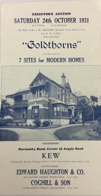
Document, Executor's Auction, Sunday 24th October 1931, "Goldthorns", Normanby Road, Corner of Argyle Road, Kew, 1931
Rare real estate brochure relating to the sale of a historically significant Kew mansion. The rarity the document is increased due to the photographs of the front of the house and of the extensive rear garden.Four page flyer advertising the sale of Goldthorns in Normanby Road, Kew in October 1931. The flyer contains a photograph of the front of the house, a list of its rooms, a site plan (including possible subdivisions). and a photo of the rear garden.goldthorns - normanby road, kew (vic), real estate - kew (vic), griffith family - kew (vic), gardens - kew (vic), subdivisions - kew (vic) -
 Kew Historical Society Inc
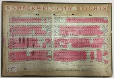
Plan - Subdivision Plan, Jas R Mathers Son & McMillan, Camberwell City Heights, 1922
"Following the 1919 amalgamation of suburban tramway trusts, an electrified tram service extended along Doncaster Road. Housing estates such as the 1919 Balwyn Park Estate, 1922 Hillcrest Estate and the Camberwell City Heights Estate, also 1922, quickly followed. These estates were built over by expansive suburban villas, set in fine gardens and along tree-lined streets. North Balwyn, largely constructed since 1933, was typified by even grander houses, many of them in the 'ocean liner' style and seen at their most distinctive in the Riverview Estate." (Source; 'Balwyn' in eMelbourne)Portions of subdivision plan mounted on both sides of cardboard sheet. Coloured pink, probably to show allotments sold. Area covered: Doncaster Road, Mountainview Road, Panoramic Road, Cityview Road, Longview Road, Riverview Road, Hillview Road, Bulleen Road. Includes location diagram showing railway lines and existing and proposed tram routes.Cardboard backing has advertisement for "Tillock's soluble coffee"subdivision plans -- camberwell (vic.), camberwell city heights subdivision -
 Kew Historical Society Inc
Plan - Subdivision Plan, J R Mathers & McMillan, Heart of Richmond Estate : Richmond, 1928
... 2013) subdivision plans - richmond (vic.) heart of richmond ..."In 1928 the land on the east side of Johnson Street was subdivided in 60 lots for the ‘Heart of Richmond Estate’. The houses in the subdivision, along the east side of Johnson Street, and in the newly created Hollick, Cole and Kennedy streets were constructed from 1928 to 1937." (Source: City of Yarra Heritage Gaps Review One 2013)Portion of subdivision plan pasted on to cardboard. Area includes Johnson Street, Victoria Street, Kennedy Street, Cole Street, Hollick Street, Bennett StreetTitle Certificate Vol.2381, Folio 476130 Phillips, Fox & Masel, 440 Little Collins Street, Melbourne (Local estate agent: Jas. R. Mathers & McMIllan, 136 Cotham Road, Kew)subdivision plans - richmond (vic.), heart of richmond estate -
 Kew Historical Society Inc
Archive (Sub-series) - Subject File, Kew Historical Society, 'Goldthorns' (Houses, Kew), 1958
Various partiesReference, Research, InformationSecondary Values (KHS Imposed Order)Subject file containing Executor's Auction, Sunday 24th October 1931, "Goldthorns", Normanby Road, Corner of Argyle Road, Kew’ - Four page flyer advertising the sale of Goldthorns in Normanby Road, Kew in October 1931. The flyer contains a photograph of the front of the house, a list of its rooms, a site plan (including possible subdivisions) and a photo of the extensive rear garden.goldthorns - normanby road - kew (vic),, goldthorns estate, mansion - kew (vic), gardens - kew (vic), griffiths family, subdivisions - kew (vic)goldthorns - normanby road - kew (vic),, goldthorns estate, mansion - kew (vic), gardens - kew (vic), griffiths family, subdivisions - kew (vic) -
 Kew Historical Society Inc
Map, Real Estate Map of Bulleen, Templestowe, Lower Templestowe, Doncaster, North Balwyn
A large undated printed map of Bulleen, Templestowe, Lower Templestowe, Doncaster, North Balwyn showing major and minor roads, waterways and proposed facilities in this area of Melbourne.A useful if undated real estate map that allows viewers to compare current and historic aspects of these areasMap of Bulleen, Templestowe, Lower Templestowe, Doncaster, North Balwyn used by JB Thomson & Co, Real Estate Agents, to identify and record land sales on these. There are some markings on the plan indicating the location and price of lots.subdivision plans, bulleen, templestowe, lower templestowe, doncaster, north balwyn -
 Kew Historical Society Inc
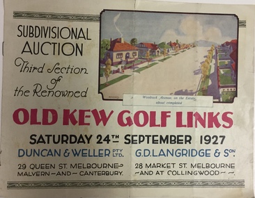
Booklet, Duncan & Weller Pty Ltd, Old Kew Golf Links Estate, 1927, 1927
The booklet advertises the third sale within the Old Golf Links Estate which was a major subdivision of farmland in North Kew in the 1920sThe subdivision of the Kew Golf Links Estate was a major subdivision of farmland in Kew. The site was at one stage designated for industrial development and the building of a new Kodak factory. The decision by Council to oppose the redevelopment makes the beginning of the period when all industrial development was banned in Kew.6 page illustrated brochure advertising the third section of a major subdivision in Kew in 1927 including 75 charming home allotments and 7 valuable building sites. The brochure includes the subdivision plan. The front cover includes a colour illustration of the almost completed houses in Woolcock Avenue. Streets named include: Kilby Road, Kodak Avenue, Baker Avenue, Mathers Avenue, Coleman Avenue, White Avenue and Belford Road. Lots for sale are numbered. Existing buildings are designated with a square.subdivisions - kew (vic), kew golf links estate -
 Kew Historical Society Inc
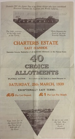
Plan - Subdivision Plan, Charteris Estate, East Ivanhoe, 1939
The Charteris Estate in Ivanhoe was sold in a number of sections. Copies of a subdivision plan of the first section is in the State Library of Victoria collection. This later section of the Charteris Estate includes lots in the Government Boulevard, Castella Street, McArthur Road, Burke Road North, Charteris Drive and Warncliff Road.Subdivision plans like that for the Charteris Estate are invaluable records for local historians identifying when lots in streets were promoted for sale.Four-fold brochure advertising the Charteris Estate in East Ivanhoe in 1939. Streets named on the plan include: the Government Boulevard, Castella Street, McArthur Road, Burke Road North, Charteris Drive and Warncliff Road. The brochure contains photos of Charterisville, the home of F De Castella Esq and also of attractive rolling hills. Annotations in pencilcharteris estate - east ivanhoe (vic), subdivision plans - east ivanhoe (vic) -
 Kew Historical Society Inc
Plan - Subdivision Plan, Charteris Estate, East Ivanhoe, 1939
The Charteris Estate in Ivanhoe was sold in a number of sections. Copies of a subdivision plan of the first section is in the State Library of Victoria collection. This later section of the Charteris Estate includes lots in the Government Boulevard, Castella Street, McArthur Road, Burke Road North, Charteris Drive and Warncliff Road.Subdivision plans like that for the Charteris Estate are invaluable records for local historians identifying when lots in streets were promoted for sale.Four-fold brochure advertising the Charteris Estate in East Ivanhoe in 1939. Streets named on the plan include: the Government Boulevard, Castella Street, McArthur Road, Burke Road North, Charteris Drive and Warncliff Road. The brochure contains photos of Charterisville, the home of F De Castella Esq and also of attractive rolling hills. Annotations in pencilcharteris estate - east ivanhoe (vic), subdivision plans - east ivanhoe (vic)