Showing 105 items
matching survey instruments
-
 Federation University Historical Collection
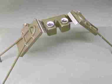
Instrument - Scientific Instruments, Universal Stereoscope
... of Mines. Used in Surveying classes. scientific instruments ...Initially made for and used by the military forces. Subsequently acquired (as army surplus equipment?) by the Ballarat School of Mines. Used in Surveying classes.A stereoscope arranged for positioning over a horizontal surface stored in a sturdy grey wood carry case. Spare set of mirrors attached to inside of box lid.scientific instruments, surveying, ballarat school of mines, stereoscope, map reading -
 Federation University Historical Collection
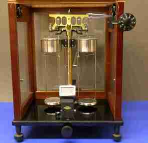
Instrument - Scientific Instruments, Sartorius Werke, Beam Balance, pre 1940?
... of Federation University Australia. scientific instruments surveying ...Used in the Ballarat School of Mines and Ballarat Institute of Advanced Education Physocs Laboratories. Both are predecessor institutions of Federation University Australia. A "late model" manual beam balance, with mechanically applied milligram masses and optically displayed balance point. Built into a resowood frame cabinet. Complete with: .2) light source .3) transformer. Serial Number 98700scientific instruments, surveying, physics, ballarat school of mines, ballarat institute of advanced education, beam balance, balance -
 Federation University Historical Collection
Instrument - Scientific Instruments, Spectroscope
... -emitting substance. scientific instruments surveying microscope ...This item has applications in teaching Physics and Chemistry - obtaining information about the atomic structure of the light-emitting substance. An optical instrument that employed a monochromatic light source, a prism (missing), and viewing lenses mounted in a tube that can be in any radial position with respect to the vertical axis of the prism. House in a polished timber carry box.Manufacturers' and suppliers names stamped on the vernier disc: "Made by W. & J. George Ltd, Birmingham, England" and "For H.B. SELBY & Co, SYDNEY & MELBOURNE. No 266"scientific instruments, surveying, microscope, physics, chemistry, atomic structure, spectroscope -
 Federation University Historical Collection
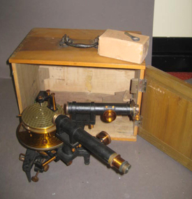
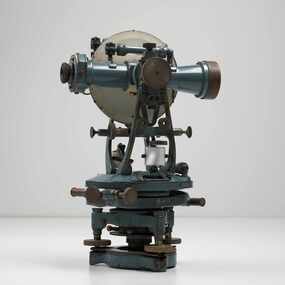
Scientific Instrument, Theodolite: Early 1900s, c1860
... instrument maker theodolite surveying european instrument importers ...The theodolite is used in surveying and measures vertical and horizontal angles. Placed on a tripod, it is used to find angles in road building, tunnel alignment and other civil-engineering work. The theodolite was used at Ballarat School of Mines in the surveying course. It is possible that this instrument was imported by Flavelle Bros & Co having been made to their order by a European instrument makerTheodolite (without a matching tripod) with four leveling screws at the base. Telescope not fully rotatable, ends can be interchanged. Underslung levelling bubbletheodolite, surveying, european instrument, importers, ballarat school of mines, flavelle bros & co, measuring angles, road building, civil engineering -
 Federation University Historical Collection
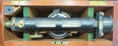
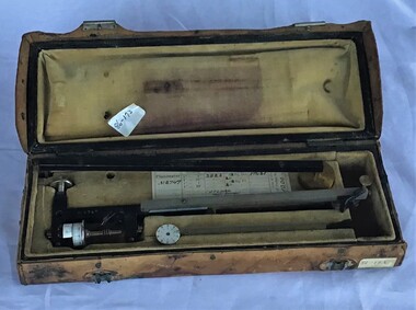
Instrument - Scientific Instrument, W.M. Drummond & Co, Surveying Level
... instruments A surveying level. Longitude and transverse bubbles ...Used for survery at the Ballarat School of Mines for Civil and Mining classes.A surveying level. Longitude and transverse bubbles, magnet, compass. External focussing. Twin vertical inclined hair lines. Four levelling screws. Objectove lens with dust shield. Fits tripod cat. no. 04132thodolite, surveying, ballarat school of mines, w.m. drummond, civil engineering, mining engineering, scientific instruments -
 Federation University Historical Collection
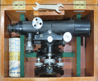
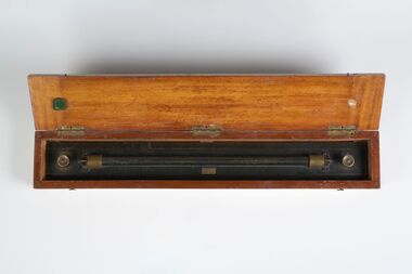
Instrument - Scientific Instrument, Dumpy Level, 05/1950
... surveying scientific instrument e.r. watts & son ltd ballarat school ...Used for surveying classes at the Ballarat School of Mines.Telescope with cross hairs and stoidia wites. Internal focussing. Vertical tilt adjusted with vernier mocrometer screw mirror lid longitudinal bubble level. Pea bubble level on plate. Housed in wooden storage carry box. Fits tripod cat. no. 4118Serial number 67543 On box lid in white paing "L 6". In yellow paing "59". Inside box lid - Manufacturers label; grades table label, calibration label reading "instrument No 67 543, date 13.5.50" (ink faded) constant: +0.19 ft"dumpy, level, surveying, scientific instrument, e.r. watts & son ltd, ballarat school of mines -
 Federation University Historical Collection
Books, H.E. Daw Government Printer, Ballarat School of Mines and Industries Departmental Papers, 1914-1950, 1914-1950
Used at the Ballarat School of Mines and the Ballarat Technical Art SchoolThis collection of examinations is significant because of its completeness with the full range of examinations between 1914 and 1950.Large leather bound books, with leather spine, containing all examinations held at the Ballarat School of Mines (including the Ballarat Technical Art School and Ballarat Junior Technical School). The examination papers were supplied and printed by the Education Department, Victoria. Examinations include: Agriculture, Algebra, Architecture, Arithmetic, Applied Mechanics, Assaying, Biology, Botany, Boilermaking, Building Design, Blacksmithing, Bricklaying, Carpentry and Joinery, Coachbuilding, Cabinet Making, Civil Engineering, Cabinet Making, Commercial, Chemistry, Engineering Drawing, Economics, English, Electrical technology, Electricity and Magnetism, Electric Wiring, Electric Welding, Electrical Fitting, Electrical Trades, Food Analysis, Geology, Geological Mapping, Graphics, Geometry, Heat Engines, Heat Treatment, Hydraulics, Hand Railing, Instrument Making, Millinery, Milling and Gearouting, Machine Shop Practice. Metal Founding, Mining, Metallurgy, Mineralogy, Mathematics, Motor Mechanics, Mine Surveying, Mining Mechanics, Petrology, Physics, Painting and Decorating, Pattern Making, Plastering, Plumbing and Gasfitting, Printing, Refrigeration, Spelling, Science , Shorthand, Surveying. Signwriting. Sheet Metalwork, Toolmaking, Ladies Tailoring, Trigonometry, Typewriting, Welding, Commercial Geography. Millinery, Dressmaking, Needlework, Decorative Needlework, Architecture, Building Design and Construction, Art (Composition in Form and Colour), Art (Casting Clay MOdels) Art (Drapery), Art (Drawing the Human Figure From Casts), Art (Drawing the Antique from Memory), Art (Drawing from Memory); Art (Drawing Plant Forms from Nature, Art (Drawing Plant Forms From Memory), Art (Drawing from Models and Objects), (Drawing From a Flat Example). Art (Drawing in Light and Shade from a Cast of Ornament or Lower Nature), Art (Drawing Ornament from the Cast), Art (Drawing from Models or Objects), Art (Drawing fro Dressmakers' and Milliners' Fashions), Art (Drawing With the Brush), Art (Drawing from a Flat Example); Art (Modelled Design), Art (General Design), Art (Embossed Leatherwork), Art (Practical Plane Geometry), Art (Practical Solid Geometry), Art (Geometrical Drawing), Carpentry and Joinery, Art (Human Anatomy), Art (Historic Ornament), Art (House Decoration), Art (LEttering), Signwriting, Art (Light Metalwork), Art (Modelling), Art (Modelling the Human Figure from a Life), Art (Stencilling); Art (Wood Carving) Refrigeration, Teaching, Boilermaking, Blacksmithing, Carpentry and Joinery, Coachbuilding and Carriage Drafting, Electric Wiring, Electrical Fitting, Graining and Marbling, Instrument Making , Machine Shop Practice, Metal Founding, Milling and Gear Cutting, Motor Mechanics, Painting and Decorating, Sheet Metalwork, Toolmaking, Printing, Pattern Making, Plumbing and gasfitting, examinations, ballarat school of mines, ballarat technical art school, trades, education department victoria, agriculture, algebra, architecture, arithmetic, applied mechanics, assaying, biology, botany, boilermaking, building design, blacksmithing, bricklaying, carpentry and joinery, coachbuilding, cabinet making, civil engineering, commercial, chemistry, engineering drawing, economics, english, electrical technology, electricity and magnetism, electric wiring, electric welding, electrical fitting, electrical trades, food analysis, geology, geological mapping, graphics, geometry, heat engines, heat treatment, hydraulics, hand railing, instrument making, millinery, milling and gearouting, machine shop practice, metal founding, mining, metallurgy, mineralogy, mathematics, motor mechanics, mine surveying, mining mechanics, petrology, physics, painting and decorating, pattern making, plastering, plumbing and gasfitting, printing, refrigeration, spelling, science, shorthand, surveying, signwriting, sheet metalwork, toolmaking, ladies tailoring, trigonometry, typewriting, welding., dressmaking, needlework, decorative needlework, architecture, building design and construction, art (composition in form and colour), art (casting clay models), art (drapery), art (drawing the human figure from casts), art (drawing the antique from memory), art (drawing from memory), art (drawing plant forms from nature, art (drawing plant forms from memory), art (drawing from models and objects), (drawing from a flat example), art (drawing in light and shade from a cast of ornament or lower nature), art (drawing ornament from the cast), art (drawing from models or objects), art (drawing for dressmakers' and milliners' fashions), art (drawing with the brush), art (drawing from a flat example), art (modelled design), art (general design), art (embossed leatherwork), art (practical plane geometry), art (practical solid geometry), art (geometrical drawing), art (human anatomy), art (historic ornament), art (house decoration), art (lettering), art (light metalwork), art (modelling), art (modelling the human figure from a life, art (stencilling), art (wood carving), teaching, coachbuilding and carriage drafting, graining and marbling, milling and gear cutting, commercial geography, exams, examination book -
 Federation University Historical Collection
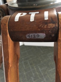
Instrument - Scientific Instruments, W.& L.E. Gurley, Collapsible Leg Surveying Instrument: Tripod
... used. tripod surveying scientific instrument ballarat school ...Used with the Plane Table - Item 4130, in surveying classes at Ballarat School of Mines. Item 4127, Tripod Location Chains, may also have been used.A large tripod of timber construction. Concave top mount flange to receive matching spherical spigot. Spacer block halfway up each twin-strut leg.In white paint on the top "PTI" Manufacturer's stamp on each leg - circular. "W.& L.E. GURLEYtripod, surveying, scientific instrument, ballarat school of mines, plane table, location chains, w & l e gurley -
 Stratford and District Historical Society
Theodolite
This theodolite was used by `Mr Dawson' (presumably William Tennant Dawson c.1820-1873) who `surveyed much of the area around and beyond Stratford'. It was damaged by the fire which burnt the original Roseneath home in 1921, when the Macleods were in residence. (Mrs W.T. Dawson was a Macleod). One little boy aged 3 years was given the job of saving everything on the kitchen table when the fire started at breakfast time. The theodolite was possibly in use by Dawson when he laid out St Kilda Road.This theodoite consists of a bottom plate, which is damaged and has melted metal. This rises to a ball joint, on which is pivoted another plate on which were housed four screws, of which three remain, to adjust the level. Above this is another plate, with compass markings and melted glass."Troughton and Simm's/London" in fine engraving on upper plate.surveyors, instruments -
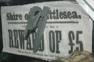 City of Whittlesea
Instrument - Surveying instrument, Clinometer
... Surveying equipment Metal Clinometer Instrument Surveying instrument ...Clinometer- used for measuring the slope of the landMetalsurveying equipment -
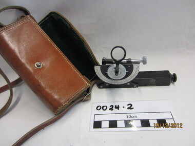 Wannon Water
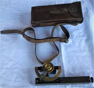
Clinometre / Abney Level, E. R. Watts & Son, Clinometre
Abney Level / Clinometer is an accurate surveying tool used to measure degrees, percent of grade and topographic elevation. Used for surveying pipe lines.Instrument which consists of a fixed sighting tube, a movable spirit level connected to a pointing arm which turns and pivots. Adjustment knob/screw on top turns to rotate the compass indicator and bubble level. Arched scale graduated 0 to 90 degrees in both directions. Clinometer is housed in a brown leather case with a long leather strap for carrying around the neck.Watts London / No 70131 / Made in England -
 Creswick Campus Historical Collection - University of Melbourne
Equipment, Spiegel Relaskop
Instrument. Relascope. The relascope, invented by Walter Bitterlich, is a multi-use instrument for forest inventory. It is primarily used to find height of a tree, basal area of a tree and diameter of a tree anywhere along the bole. This instrument is used mostly for applications involving variable radius sample plots in a forest survey.Equipment32485 -
Stawell Historical Society Inc
Instrument - Realia, Surveying Level or Dummy level or Transit Level in case
Property of William Ernest Coward. Builder in stawell from 1915 - Mid 1960's. Used in Building setting levelsDark grey optical instument in case, with wooden tripodMiddleton & Co Pty Ltd Melbourne A.E. Parson Melbourne CM4/BB 1623 -
Tatura Irrigation & Wartime Camps Museum
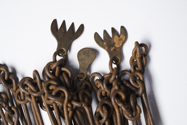
Gunter's Chain
This is a surveyor's chain or Gunter's chain, an instrument used for measuring length. It comprises 100 pieces of straight metal wire, looped together end to end, and fitted with swivel handles. Its overall length is one chain (22 yards or 66 feet). The Gunter's chain was named after its inventor, Edmund Gunter (1581-1626), an English clergyman, mathematician, and astronomer. survey -
Moorabbin Air Museum
Book (Item) - A survey of instrument parts - Fluid Film Bearings by PJ Geary
... A survey of instrument parts - Fluid Film Bearings by PJ... Moorabbin melbourne Book A survey of instrument parts - Fluid Film ... -
 Queenscliffe Maritime Museum
Instrument - Surveying Hydrographic measuring Instrument
... in the 1930s. surveying instrument hydrography larkin jp Purton ...Survey tape used by P.J. Larkin, government surveyorInstrument owned and used by a government marine surveyor named P. J. Larkin who worked in Melbourne and Geelong in the 1930s.Survey tape in leather pouch about 100 feet long and housed on brass reel.Purton and Littlejohn's patent Wellington 1663surveying instrument, hydrography, larkin jp -
 Queenscliffe Maritime Museum
Instrument - Planimeter in leather box
... and 30s in Port Phillip and Quennscliff surveying instruments p j ...This planimeter in leather box was used by P. J. Larkin, government surveyor, for measuring irregular areas in plans and charts. This type of instrument is still used today and is useful for computing dredging volumes.Surveyor active in the 20s and 30s in Port Phillip and QuennscliffA Planimeter in its own leather box.The Adams Engineering Co. Wellington N.Z. No 8747surveying instruments, p j larkin -
 Queenscliffe Maritime Museum
Instrument - Clinometer in leather case
Instrument used by J P Larkin, government marine surveyor active in Port Phillip and Queenscliff in the 20s and 30sA clinometer in its own leather case.T. Cooke and Sons Ltd London and Yorksurveying equipment, j p larkin -
 National Communication Museum
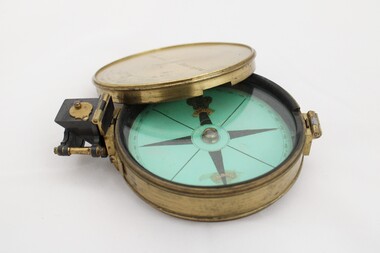
Equipment - Prismatic compass, Alfred E Sawtell, before 1872
After years of precursory surveying, debate and proposals the most ambitious civil engineering project of the day, the Overland Telegraph Line, began construction in September 1870. Superintendent of Telegraphs, Sir Charles Todd led the construction through “terra incognita,” guided by the precursory surveys of John McDowall Stuart and technologies such as his prismatic surveying compass. The unknown and hostile landscape claimed the lives of several men and scores of transport animals in the dogged pursuit of telegraphic connection to the rest of the world. Completed in August 1872, the Line connected Australia to the world via telegraph wires running 3,200 kilometres from Port Augusta in South Australia, to Darwin, then connecting via submarine cable to Java and beyond. The “earth [had been] girdled with a magic chain” according to the then Governor of New South Wales, Sir Hercules Robinson. How does it work? For use in surveying, the sight vane and prism are turned up on their hinge and the instrument is held horizontally either in the palm of one's hand or on a tripod. Two small discs of red and green glass attached to the prism can be flipped down over the sight line to reduce glare. The objective is to bring the subject into the sightline created by the prism, aligning with the thread of the sight-vane until the subject is bisected evenly. Once aligned, the division on the card may be read through the prism. This reading provides the magnetic azimuth, used for calculating the bearings of distant landmarks. Circular instrument mounted in a brass case with glass window and brass lid. The compass card face four black compass points printed on mint green paper; on the underside the magnetic needle would be affixed, all held in place by a brass knob at the centre. The arched labels of "Sawtell" and "Adelaide" and the Prince of Wales feathers appear to have been affixed with adhesive which has since yellowed in the areas of application on the compass card. The compass face is printed with numbers, every 10 degrees from 10 - 360, printed in reverse indicating this compass would have once held a mirror at the sighting bracket. On one side of the brass case is a brass hinged sighting-prism, possibly of ebonite. The sighting-prism is mounted in a hinged brass bracket on one edge of the brass case. It has two flip-type filter glasses (red and green) and folds down into a retracted travelling position. A hinged brass bracket on the opposite edge would have held the sighting bracket - carrying the sighting vane and mirror - which is now missing or removed. Under the hinge is a lever, possibly related to the movement of the bracket. Underneath the brass case is an indented circle with screw threads, possibly for attachment to a tripod, and indistinguishable marks scratched into the surface.Etched on to the centre of the lid, "Sawtell ADELAIDE / No 792." Affixed to the paper compass face, possibly from separate pieces of paper, "SAWTELL / ADELAIDE" with the Prince of Wales Feathers above "SAWTELL". Underneath on remains of white tape in red: "159."surveying, compass, charles todd, overland telegraph line, telegraph -
 City of Greater Bendigo - Civic Collection
Instrument - Gunter Chain, not known
Gunter's chain (also known as Gunter’s measurement) is a distance measuring device used for surveying. It was designed and introduced in 1620 by English clergyman and mathematician Edmund Gunter (1581–1626). It enabled plots of land to be accurately surveyed and plotted, for legal and commercial purposes. The provenance of this particular Gunter Chain is unknown but it is believed to be used either by the City of Bendigo / Sandhurst or the Lands Department locally when measuring and laying out plots and streets locally. A 66-foot (20.1 m) chain divided into 100 links, marked off into groups of 10 by brass rings or tags. Each link is 7.92 inches (201 mm) long. A quarter chain, or 25 links, measures 16 feet 6 inches (5.03 m) also called a a rod (or pole) measure. Ten chains measure a furlong and 80 chains measure a statute mile. city of greater bendigo surveying -
 City of Greater Bendigo - Civic Collection
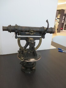
Instrument - Theodolite, Cooke, Troughton & Simms, c 1940
Theodolites are a highly accurate instrument that measures angles between designated visible points in the horizontal and vertical planes. The theodolite has a long history, with the term first found in 1571 in a surveying textbook 'A geometric practice named Pantometria' by Leonard Digges. (source https://en.wikipedia.org/wiki/Theodolite). Cooke Troughton & Simms began when John Troughton starting selling products in Fleet Street, London in 1782. He went into partnership with his brother Edward in 1807 who expanded the business considerably. William Simms, a former apprentice with the company was taken as a partner and then manager after Edward died in 1835 and the company became Troughton & Simms. By 1887 the company was able to produce all the parts necessary for their instruments and the company employed nearly 200 people and was one of the most well respected firms of instrument makers of the 1800's. James Simms, son of William who had inherited the company died in 1915 and the company was turned into a limited liability company by his two sons William and James. Things however were not so easy for the two sons and in 1922 the business was brought out by their rival T. Cooke & Sons becoming Cooke, Troughton & Simms. Theodolites are used by surveyors as part of their everyday work and although there is no specific information regarding the provenance of this particular one it is assumed it was used locally by the City of Bendigo and / or the Lands Department.A grey theodolite no 39161 made by Cooke, Thoughton & Simms. Various moving parts showing signs of extensive use particularly on the uprights on the main body and around knobs and dials where the paint is worn back to brass.Cooke, Thoughton & Simms Ltd / York. England / No 39161. Sticker; DPS - Asset No / (barcode) / 0010173city of greater bendigo administration item, lands and survey department bendigo -
 City of Greater Bendigo - Civic Collection
Equipment - Rolling Parallel Ruler, Kilpatrick and Co
Kilpatrick and Co were London based Mathematical Instrument Makers, Opticians, Goldsmiths, Jewellers and Watchmakers who operated in Melbourne at various Collins Street addresses between 1876 and 1898. Believed to have been a part of the Shire of Marong's surveying equipment.Rectangular brass ruler with beveled edges and rollers on underside. Housed in custom made hinged wooden box. Centre front; Kilpatrick & Co., Londoncity of greater bendigo surveying, shire of marong -
 City of Greater Bendigo - Civic Collection
Instrument - Theodolite, E. R. Watts & Sons, c 1930
Theodolites are a highly accurate instrument that measures angles between designated visible points in the horizontal and vertical planes. The theodolite has a long history, with the term first found in 1571 in a surveying textbook 'A geometric practice named Pantometria' by Leonard Digges. (source https://en.wikipedia.org/wiki/Theodolite). Theodolites are used by surveyors as part of their everyday work and although there is no specific information regarding the provenance of this particular one it is assumed it was used locally by the Shire of Marong and / or the Lands Department. Edwin Watts started the company in 1856, trading up to 1920s as E.R. Watts & Son with E. R. Watts & Son Ltd amalgamating with Adam Hilger Ltd to form Hilger & Watts in 1948.0442.1 A black and grey theodolite no 39161 made by Watts & Sons. Various moving parts showing signs of extensive use particularly on the uprights on the main body and around knobs and dials where the paint is worn back to brass. Is housed in original box with key, oil container and pin. 0442.2 handwritten instructions for making adjustments to the Theodolite written on the back of Road Users' Association of Victoria letterhead note paper.Watts & Sons / London / 5974 For N H Seward / Melbournelands and survey department bendigo, shire of marong -
 Parks Victoria - Cape Nelson Lightstation
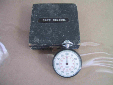
Instrument - Watch, stop
The date of manufacture and age are unknown. It is believed to be original to the lightstation. Of six Victorian lightstation collections surveyed, Cape Nelson is the only one with a stop‐watch. The watch is significant as an intact and relatively uncommon object remaining at a Victorian lightstation and has first level contributory importance for its historical values.The circular, top‐winding metal stop‐watch has an associated blue velvet‐lined, square case. The watch bears an inscription but the date of manufacture and age are unknown. It is believed to be original to the lightstation. The watch bears an inscription etched into the back." C. of A. / C.L.S. /^ / No 101" and on a sticker "C of A / D.O.T. ....." -
 Forests Commission Retired Personnel Association (FCRPA)
Surveyor's Pocket Altimeter, c 1940
This instrument measures elevation by sensing minute changes in barometric air pressure relative to a fixed datum point at sea level or a known elevation, such as the starting point of a major town during a road survey, and has an accuracy of +/- 20 feet when used in experienced hands. The finely divided scale around the perimeter of the face is marked from 0 to 6000 feet elevation and 25 to 31 inches of mercury (Hg) for barometric pressure The single fine counter-balanced hand or pointer rotates anti-clockwise with increasing elevation and decreasing pressure. The label "compensated" indicates that the instrument is constructed to compensate for the effect of temperature changes on the accuracy of readings. Surveyor's Pocket Altimeter - Aneroid Barometer Type Branded N H Seward, Melbourne. Made in England. With leather carrying case and strap.forest measurement, forests commission victoria (fcv), surveying -
 Bendigo Military Museum
Document - DOCUMENTS WW2, C. 1945
Part of the HEWSTON collection re WW1 & WW2. This Instrument of Surrender was hand drafted by Sgt George Ricketts Survey Corps attached to the Survey unit on Moratai..1) Instrument of Surrender, lithograph copy. .2) Address Delivered by Commander in Chief. .3) Formal Surrender of Second Japanese Army. .4) Photo. Items are different sizes.documents - addresses / military / history, japanese surrender -
 Bendigo Military Museum
Photograph - 4th Field Survey Squadron deployed on Operation NERIGHT, Queensland & Northern Territory, 1989
This is a set of 19 photographs taken in 1989 during 4th Field Survey Squadron’s deployment on Operation NERIGHT 89 in Queensland and the Northern Territory. It was a two-part operation in 1989 with work conducted in the areas of Camooweal and Weipa. Part 1 was the field completion of topographic maps conducted near Camooweal QLD, along the Barkley Highway on the border between NT and QLD, from the 12th of September to the 20th of October 1989. A Bell Kiowa LOH helicopter from 162 Recce Sqn supported topographic field completion. Operation NERIGHT 89 Part 2 was the acquisition of mapping control by GPS field parties utilising Texas Instruments TI4100 Global Positioning System receivers around Weipa on Cape York Peninsula from the 22nd of September to the 22nd of October 1989. Part 2 Two Bell UH-1H Iroquois helicopters from RAAF’s 35 Squadron were principally used to deploy GPS field parties. Identification photography of control points was taken by air camera operators in AAAvn Pilatus Porter aircraft from 173 Gen Spt Sqn fitted with an RC10 aerial camera. The two parts of the operation were conducted concurrently. This is a set of 19 photographs taken in 1989 during 4th Field Survey Squadron’s deployment on Operation Neright in Queensland & the Northern Territory. The colour photographs are on 35mm negative film and are part of the Army Survey Regiment’s Collection. The photographs were scanned at 96 dpi. .1) to .3) - Photo, colour, 1989. En-route to areas of survey operations. .4) to .5) - Photo, colour, 1989. Unidentified personnel relax next to river/waterhole. .6) - Photo, colour, 1989. Two Bell UH-1H Iroquois helicopters from RAAF’s 35 SQN utilised in the movement of GPS parties. .7) to .9) - Photo, colour, 1989. Unidentified soldier practices repelling from a UH1H Iroquois helicopter. .10) - Photo, colour, 1989. Inside the cockpit of a UH1H Iroquois helicopter. .11) - Photo, colour, 1989. Field Party camp with GPS equipment in foreground. Unidentified soldier prepares a meal. .12) - Photo, colour, 1989. GPS antenna plumbed over a survey ground mark. Witness post on left. .13) & .14) - Photo, colour, 1989. Unknown Cape York Peninsula beaches. .15) & .16) - Photo, colour, 1989. Dramatic fire next to base camp. .17) - Photo, colour, 1989. Aboriginal rock art at unknown location. .18) - Photo, colour, 1989. Aboriginal rock art at unknown location. L to R: unidentified, SPR Andrew Quin. .19) - Photo, colour, 1989. Aboriginal rock art at unknown location. LT Chris Topovsek..1P to .19P – There are no personnel identified. ‘1989 OP NERIGHT’ annotated on negative sleeve.royal australian survey corps, rasvy, 4 fd svy sqn, op neright 89 -
 Bendigo Military Museum
Photograph - Demonstration of TI4100 GPS Receiver, Royal Australian Survey Corps, c1988
This is a set of four photographs of WO2 Graham Ragless from the Royal Australian Survey Corps demonstrating the operation of Global Positioning System equipment in c1988. The photos were probably taken at the School of Military Survey (SMS), Bonegilla, VIC. Texas Instruments TI4100 portable Global Positioning System (GPS) geodetic receivers were introduced from 1986–1988. The GPS receivers and Ferranti FILS3 helicopter and vehicle mounted Inertial Positioning System (IPS) replaced the TRANSIT satellite receivers. The equipment was deployed to establish the baseline for a GPS controlled air camera and photogrammetric system to significantly reduce the requirement for ground survey to accurately control air photography for topographic mapping. Personnel from the four field survey squadrons at this time were trained at the SMS to operate the TI4100 receivers. Field survey operations using GPS and IPS equipment followed in the late 1980s. This technology is described in more detail in the RA Svy booklet titled An Introduction to Topographic Mapping. See record ID - 6010. WO2 Graham Ragless progressed to the rank of WO1 and was appointed as RSM of the Army Survey Regiment from 1990 to 1992. Refer to item 6186.2P for more photographs of WO2 Graham Ragless demonstrating the TI4100.This is a set of four photographs of a technician from the Royal Australian Survey Corps demonstrating the operation of Global Positioning System equipment in c1988. Colour photos are on 35mm slide film and were scanned at 96 dpi. .1) to .4) - Photo, colour, c1988, WO2 Graham Ragless demonstrating the operation of a TI4100 GPS receiverThere are no annotations.royal australian survey corps, rasvy, army survey regiment, army svy regt, fortuna, asr, surveying -
 Bendigo Military Museum
Photograph - Demonstration of TI4100 GPS Receiver, Royal Australian Survey Corps, c1988
This is a set of two photographs of WO2 Graham Ragless from the Royal Australian Survey Corps demonstrating the operation of Global Positioning System equipment in c1988. The photos were probably taken at the School of Military Survey (SMS), Bonegilla, VIC. Texas Instruments TI4100 portable Global Positioning System (GPS) geodetic receivers were introduced from 1986–1988. The GPS receivers and Ferranti FILS3 helicopter and vehicle mounted Inertial Positioning System (IPS) replaced the TRANSIT satellite receivers. The equipment was deployed to establish the baseline for a GPS controlled air camera and photogrammetric system to significantly reduce the requirement for ground survey to accurately control air photography for topographic mapping. Personnel from the four field survey squadrons at this time were trained at the SMS to operate the TI4100 receivers. Field survey operations using GPS and IPS equipment followed in the late 1980s. This technology is described in more detail in the RA Svy booklet titled An Introduction to Topographic Mapping. See record ID - 6010. WO2 Graham Ragless progressed to the rank of WO1 and was appointed as RSM of the Army Survey Regiment from 1990 to 1992. Refer to item 6226.4P for more photographs of WO2 Graham Ragless demonstrating the TI4100.This is a set of two photographs of a technician from the Royal Australian Survey Corps demonstrating the operation of Global Positioning System equipment in c1988. Colour photos are on 35mm slide film and were scanned at 96 dpi. .1) and .2) - Photo, colour, c1988, WO2 Graham Ragless demonstrating the operation of a TI4100 GPS receiverThere are no annotations.royal australian survey corps, rasvy, army survey regiment, army svy regt, fortuna, asr, surveying -
 Bendigo Military Museum
Photograph - RA Svy Project C4 Aerodist Operation, Eastern Arnhem Land, NT, 1967
This is a set of 30 photographs of Royal Australian Survey Corps (RA Svy) personnel from Central Comd Fd Svy Unit (Adelaide) on Aerodist survey operation - Project C4 in Eastern Arnhem Land, Northern Territory in 1967. Photos of personnel were taken either at the operations base at Numbulwar or the main base at Gove (Nhulunbuy). RA Svy conducted nineteen Aerodist operations for 12 years from 1964 to 1975. Aerodist MRC2 was a tellurometer-based system adapted for aircraft to accurately measure distances between non-intervisible ground survey stations, using the aircraft as an intermediate station. Lower order geodetic results could be achieved by survey network trilateration. The measured distances between stations formed survey networks from which each station’s latitude and longitude was computed. Aerodist MRC2 was RA Svy’s major horizontal control survey tool for mainly medium scale topographic mapping (scale 1:100,000 Class A being spatially accurate to within 50 metres) in PNG, northern NT, north-west WA, Kalimantan Barat (West) Indonesia, Sumatra Indonesia, Gulf of Carpentaria and Cape York, QLD. In 1967, the Aerodist MRC2 Master equipment was installed in the aircraft featured in this set of photos, Executive Air Services’ (Essendon VIC) Grand Aero Commander VH-EXX. It was the same aircraft type and company contracted to Division of National Mapping for Aerodist MRC2 surveys. From July to October 1967 the aircraft was attached to Central Comd Fd Svy Unit (Adelaide - Major Don Ridge) on Project C4 eastern-Arnhem Land NT, where 317 Aerodist lines measuring 17,300 line miles were successfully completed. This was the most productive Aerodist project thus far. The most common helicopter used by RA Svy up to 1972 was the civilian Bell 47G-2 and the Sioux Light Observation Helicopters (LOH), the Australian Army’s equivalent featured in this photo set. These light observation helicopters had a limiting load carrying capacity of up to about 500 pounds. By comparison, one Aerodist team including two people weighed up to 1,500 pounds. Source: Royal Australian Survey Corps – Aerodist Years 1964-1975 by Peter Jensen. This is a set of 30 photographs of Royal Australian Survey Corps (RA Svy) personnel on Aerodist survey operations in Eastern Arnhem Land, Northern Territory in 1967. The photographs are on 35mm negative film and scanned at 96 dpi. They are part of the Army Survey Regiment’s Collection. .1) to .4) - black & white, 20th August 1967, Project C4 Aerodist Operations Base - Numbulwar, NT. .5) - Photo, black & white, 1967. Probable wrecked Indonesian fishing vessel. .6) to .8) - Photo, black & white, 1967. Unidentified survey operations base, L to R: unidentified personnel. .9) - Photo, black & white, 1967. Unidentified survey operations base, unidentified soldier driving a Haflinger 4x4 Light utility vehicle. .10) - Photo, black & white, 1967. Unidentified survey operations base, L to R: unidentified technician. .11) - Unidentified technician reading two survey altimeters to compute corrections to the measured distances for atmospheric refraction and to compute the sea level distances from the slope distances aircraft to the ground stations. .12) - Photo, black & white, 1967. Unidentified survey operations base, L to R: unidentified personnel. .13) to .16) - Photo, black & white, 1967. Unidentified personnel operating remote Aerodist MRC2 ground instruments. .17) to .18) - Photo, black & white, 1967. Unknown RA Svy office location. .19) to .20) - Photo, black & white, 1967. Aerodist MRC2 Master equipment. .21) to .22) - Photo, black & white, 1967. Aero Commander VH-EXX probably at Gove, NT, Central Comd Fd Svy Unit (Adelaide) – OC Major Don Ridge. .23) to .25) - Photo, black & white, 1967. Aero Commander VH-EXX probably at Gove, NT. Unidentified personnel. .26) - Photo, black & white, 1967. Aero Commander VH-EXX probably at Gove, NT. Aerodist antenna pods are visible on the aircraft. .27) to .29) - Photo, black & white, 1967. Australian Army Sioux Light Observation Helicopter (LOH) probably at Gove, NT. .30) - Photo, black & white, 1967. Panelled U337 survey station, visible as a white cross on aerial identification photo..1P to .2P – date and location on edge of film negative. .5P to .28P – no annotations .29P - annotated in white ‘RW-JEP Gove NT’ .30P - annotated in white ‘U337 Spool No1 Jun67’royal australian survey corps, rasvy, army survey regiment, army svy regt, fortuna, asr, aerodist, surveying, central comd fd svy unit