Showing 165 items
matching timber track
-
 Marysville & District Historical Society
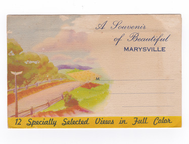
Postcard (item) - Colour photographs, Nucolorvue Productions, A Souvenir of Beautiful Marysville-12 Specially Selected Views in Full Colour, Unknown
An envelope of 12 colour photographs of attractions in and around Marysville in Victoria.An envelope of 12 colour photographs of attractions in and around Marysville in Victoria. These photographs were produced by Nucolorvue Productions in Mentone, Victoria.A Souvenir of Beautiful MARYSVILLE 12 Specially Selected Views in Full Colour Marysville, Victoria, Australia Marysville, 60 miles from Melbourne, is one of nature's/ lovely beauty spots. The invigorating mountain air helps the/ visitor to enjoy the many delightful walks amongst the tall/ timber, or through the fern glades. Apart from many excellent walking trips, Marysville district/ offers ample scope for car trips to the nearby Cumberland Forest,/ Buxton, Narbethong, or the Taggerty Valley. Skiers find Lake Mountain an attraction in the winter, whilst/ the hiker finds ample for his needs in the numerous mountain/ areas. Huge Eucalypt trees, revealing their ramrod straightness up/ to 300 feet in height, are a fitting background to the many/ beautiful creeks and waterfalls. PUBLISHED BY NUCOLORVUE PRODUCTIONS, MENTONE, VICTORIA.nicholl's lookout (image 1), eildon weir (image 2), road to lake mountain (image 3), foot of steavenson falls (image 4), steavenson falls (image 5), bush scene near marysville (image 6), bush track marysville (image 7), bridge and chalet and crossways marysville (image 8), log cabin at marysville (image 9), black spur (image 10), taggerty river (image 11), highest known hardwood tree (image 12), marysville, victoria, nucolorvue productions, postcard, souvenir -
 Marysville & District Historical Society
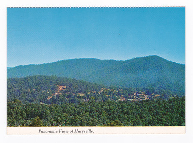
Postcard (item) - Colour postcard, Nucolorvue Productions Pty. Ltd, Panoramic View of Marysville, Pre 2009
... marysville-wood's point road yarra track mining timber mills ...A colour photograph of the view of Marysville from Barton's Lookout which is near the Cumberland Valley in Victoria.A colour photograph of the view of Marysville from Barton's Lookout which is near the Cumberland Valley in Victoria. The Cumberland Valley is notable for its giant mountain ash (Eucalyptus regnans) trees within the Cumberland Memorial Scenic Reserve, and relics from former sawmills and gold mining. The Big Culvert is located nearby on the Marysville-Woods Point Road, which was historically part of the Yarra Track. Cambarville, which is in the Cumberland Valley, was established as a timber mill town in the 1940s. Timber mill owners A Cameron and FJ Barton named Cambarville. They established the mill to salvage timber from trees destroyed in the 1939 bushfires. Cambarville was impacted by the 2009 Black Saturday bushfires and any remaining structures were destroyed. Barton's Lookout was named after a member of the Barton Family who were amongst Marysville's earliest pioneering families. This postcard was produced by Nucolorvue Productions as a souvenir of Marysville.NU-COLOR-VUE/ OF/ AUSTRALIA MARYSVILLE, VICTORIA Panoramic View of Marysville from/ CUMBERLAND. PLACE/ STAMP/ HERE POST CARD NUC.171 - NUCOLORVUE PRODUCTIONS PTY. LTD./ COPYRIGHT Printed in Australiamarysville, barton's lookout, victoria, nucolorvue productions, postcard, souvenir, cumberland valley, cumberland memorial scenic reserve, big culvert, marysville-wood's point road, yarra track, mining, timber mills, a cameron, fj barton, cambarville, 1939 bushfires, 2009 black saturday bushfires -
 Marysville & District Historical Society
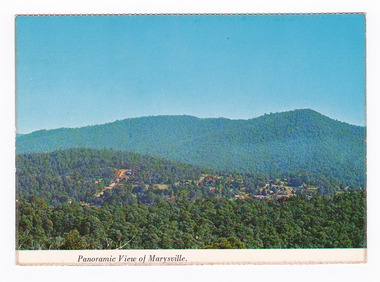
Postcard (item) - Colour postcard, Nucolorvue Productions Pty. Ltd, Panoramic View of Marysville, Pre 2009
... marysville-wood's point road yarra track mining timber mills ...A colour photograph of the view of Marysville from Barton's Lookout which is near the Cumberland Valley in Victoria.A colour photograph of the view of Marysville from Barton's Lookout which is near the Cumberland Valley in Victoria. The Cumberland Valley is notable for its giant mountain ash (Eucalyptus regnans) trees within the Cumberland Memorial Scenic Reserve, and relics from former sawmills and gold mining. The Big Culvert is located nearby on the Marysville-Woods Point Road, which was historically part of the Yarra Track. Cambarville, which is in the Cumberland Valley, was established as a timber mill town in the 1940s. Timber mill owners A Cameron and FJ Barton named Cambarville. They established the mill to salvage timber from trees destroyed in the 1939 bushfires. Cambarville was impacted by the 2009 Black Saturday bushfires and any remaining structures were destroyed. Barton's Lookout was named after a member of the Barton Family who were amongst Marysville's earliest pioneering families. This postcard was produced by Nucolorvue Productions as a souvenir of Marysville.NU-COLOR-VUE/ OF/ AUSTRALIA MARYSVILLE, VICTORIA Panoramic View of Marysville from/ CUMBERLAND. PLACE/ STAMP/ HERE POST CARD NUC.171 - NUCOLORVUE PRODUCTIONS PTY. LTD./ COPYRIGHT Printed in Australia Hi There! how are you? fine I hope....Hows school/ treating you?/ Isn't it beautiful now Autumns back again./ You'll have to come up soon and see us, where/ really you/ Ok! it beautiful, the air so fresh and/ clean it makes you want to cry. There are/ so many magnificent and brill marysville, barton's lookout, victoria, nucolorvue productions, postcard, souvenir, cumberland valley, cumberland memorial scenic reserve, big culvert, marysville-wood's point road, yarra track, mining, timber mills, a cameron, fj barton, cambarville, 1939 bushfires, 2009 black saturday bushfires -
 Marysville & District Historical Society
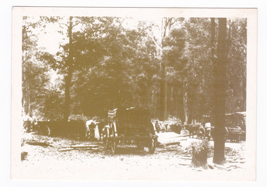
Postcard (item) - Black and white postcard, Marysville & District Historical Society Inc, Bullock Teams at the Dump, Woods Point Road, 1993
... marysville-wood's point road yarra track healesville mining timber ...A black and white photograph of bullock teams at the Log Dump at on the Wood's Point Road.A black and white photograph of bullock teams at the Dump at on the Wood's Point Road. The Marysville-Woods Point Road was originally part of the Yarra Track, constructed in the early 1860s to provide access between Healesville and the Woods Point Goldfields. Despite the steep terrain and engineering difficulties, the Yarra Track soon became a busy route used by pack horses, horse-drawn drays, and wagons. Today this sealed mountain road is a popular scenic drive between Marysville and Warburton. This postcard was produced by the Marysville Historical Society as a souvenir of Marysville.YESTERYEAR POSTCARDS AFFIX/ STAMP/ HERE BULLOCK TEAMS AT THE DUMP,/ WOODS POINT ROAD. C Marysville Historical Society, 1993marysville, bullock teams, woods point road, victoria, marysville historical society, postcard, souvenir, yesteryear postcards, marysville-wood's point road, yarra track, healesville, mining, timber mills, warburton -
 Marysville & District Historical Society
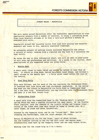
Flyer (Item) - Information Flyer, Forests Commission, Victoria, FOREST WALKS - MARYSVILLE, 1918-1983
An information flyer that was produced as a guide to the forest walks in and near Marysville by the Forests Commission of Victoria. The Forests Commission Victoria (FCV) was the main government authority responsible for management and protection of State forests in Victoria, Australia between 1918 and 1983. The Commission was responsible for ″forest policy, prevention and suppression of bushfires, issuing leases and licences, planting and thinning of forests, the development of plantations, reforestation, nurseries, forestry education, the development of commercial timber harvesting and marketing of produce, building and maintaining forest roads, provision of recreation facilities, protection of water, soils and wildlife, forest research and making recommendations on the acquisition or alienation of land for forest purposes″. An extensive network of walking tracks surrounds Marysville and they offer a variety of walks ranging in various levels of difficulty. This information flyer provides information such as the level of difficulty for six suggested walks around Marysville.An information flyer that was produced as a guide to the forest walks in and near Marysville by the Forests Commission of Victoria.marysville, victoria, australia, forest walks, forests commission victoria, beauty spot walk, tree fern gully walk, michaeldene track, keppel track, woods lookout track -
 Marysville & District Historical Society
Flyer (item) - Information Flyer, Parks Victoria, Yarra Ranges National Park-Lady Talbot Drive, Cambarville and Lake Mountain-Visitor Guide, 01-2018
A flyer that was produced as a guide to Lady Talbot Drive, Cambarville and Lake Mountain.A flyer that was produced as a guide to Lady Talbot Drive, Cambarville and Lake Mountain. Lady Talbot Drive a 24 kilometer scenic rainforest car journey which passes a number of walks and waterfalls in the Yarra Ranges National Park. Lady Talbot Drive is named after Lady Sarah Elizabeth, the wife of Sir Reginald Talbot, who was the Governor of Victoria from 25th April, 1904 to 6th July 1908. Cambarville is notable for its giant mountain ash (Eucalyptus regnans) trees within the Cumberland Memorial Scenic Reserve, and relics from former sawmills and gold mining. The Big Culvert is located nearby on the Marysville-Woods Point Road, which was historically part of the Yarra Track. Cambarville was established as a timber mill town in the 1940s. Timber mill owners A Cameron and FJ Barton named Cambarville. They established the mill to salvage timber from trees destroyed in the 1939 bushfires. Cambarville was impacted by the 2009 Black Saturday bushfires and any remaining structures were destroyed. Lake Mountain is the closest alpine cross-country ski resort to Melbourne.lady talbot drive, lady talbot forest drive, cambarville, lake mountain, sir reginald talbot, lady sarah elizabeth talbot -
 Marysville & District Historical Society
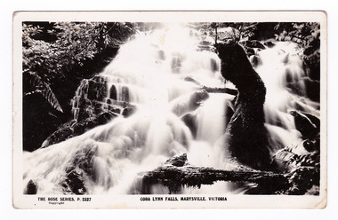
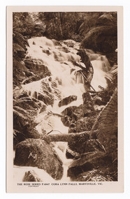
Postcard (item) - Black and white postcard, Rose Stereograph Company, Cora Lynn Falls, Marysville, Victoria, 1913-1967
A postcard in a series produced by the Rose Stereograph Company in Victoria, Australia as a souvenir of Marysville.A black and white photograph of the Cora Lynn Falls which are in Cambarville. These falls are located on the Marysville-Wood's Point Road. Cambarville is notable for its giant mountain ash (Eucalyptus regnans) trees within the Cumberland Memorial Scenic Reserve, and relics from former sawmills and gold mining. The Big Culvert is located nearby on the Marysville - Woods Point Road, which was historically part of the Yarra Track. Cambarville was established as a timber mill town in the 1940s. Timber mill owners A Cameron and FJ Barton named Cambarville. They established the mill to salvage timber from trees destroyed in the 1939 bushfires. Cambarville was impacted by the 2009 Black Saturday bushfires and any remaining structures were destroyed. POST CARD The "Rose" Series/ De Luxe A Real Photograph/ Produced in Australia Published by the Rose Stereograph Co./ Armadale, Victoria.cora lynn falls, cambarville, marysville, victoria, waterfalls, p. 2327, rose series postcard, postcard, souvenir, a cameron, fj barton, black saturday bushfires, mountain ash, mining, timber mills, 1939 bushfires -
 Marysville & District Historical Society
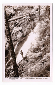
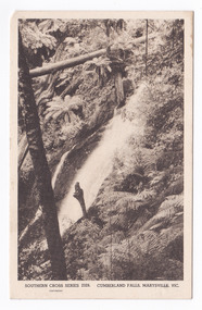
Postcard (item) - Black and white postcard, Rose Stereograph Company, Cumberland Falls, Marysville, Victoria, 1913-1967
A postcard in a series produced by the Rose Stereograph Company in Victoria, Australia as a souvenir of Marysville.A black and white photograph of the Cumberland Falls which are in Cambarville. These falls are located on the Marysville-Wood's Point Road. Cambarville is notable for its giant mountain ash (Eucalyptus regnans) trees within the Cumberland Memorial Scenic Reserve, and relics from former sawmills and gold mining. The Big Culvert is located nearby on the Marysville - Woods Point Road, which was historically part of the Yarra Track. Cambarville was established as a timber mill town in the 1940s. Timber mill owners A Cameron and FJ Barton named Cambarville. They established the mill to salvage timber from trees destroyed in the 1939 bushfires. Cambarville was impacted by the 2009 Black Saturday bushfires and any remaining structures were destroyed.POST CARD The "Rose" Series/ De Luxe A Real Photograph/ Produced in Australia Published by the Rose Stereograph Co., Armadale, Victoria.cumberland falls, cambarville, marysville, victoria, waterfalls, p. 2328, rose series postcard, postcard, souvenir, mountain ash, mining, timber mills, big culvert, yarra track, a cameron, fj barton, black saturday bushfires, 1939 bushfires, eucalyptus regnans -
 Marysville & District Historical Society
Postcard (item) - Black and white postcard, Rose Stereograph Company, Cora Lynn Falls, Marysville, Vic, 1913-1967
A postcard in a series produced by the Rose Stereograph Company in Victoria, Australia as a souvenir of Marysville.An early black and white photograph of the Cora Lynn Falls in Marysville, Victoria. These falls are located on the Marysville-Wood's Point Road. Cambarville is notable for its giant mountain ash (Eucalyptus regnans) trees within the Cumberland Memorial Scenic Reserve, and relics from former sawmills and gold mining. The Big Culvert is located nearby on the Marysville - Woods Point Road, which was historically part of the Yarra Track. Cambarville was established as a timber mill town in the 1940s. Timber mill owners A Cameron and FJ Barton named Cambarville. They established the mill to salvage timber from trees destroyed in the 1939 bushfires. Cambarville was impacted by the 2009 Black Saturday bushfires and any remaining structures were destroyed.POST CARD REAL PHOTO THE "ROSE" SERIES DE LUXE PRODUCED IN AUSTRALIA Published by The Rose Stereograph Co./ Armadale, Victoriamarysville, victoria, photograph, cora lynn falls, waterfalls, rose series postcard, rose stereograph company, souvenir, cambarville, marysville-wood's point road, eucalyptus regnans, cumberland memorial scenic reserve, mining, big culvert, yarra track, a cameron, fj barton, 1939 bushfires, 2009 black saturday bushfires, timber mills, p. 4947 -
 Marysville & District Historical Society
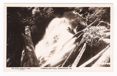
Postcard (item) - Black and white postcard, Rose Stereograph Company, Cumberland Falls, Marysville, Vic, 1913-1967
A postcard in a series produced by the Rose Stereograph Company in Victoria, Australia as a souvenir of Marysville.A black and white photograph of the Cumberland Falls which are in Cambarville. These falls are located on the Marysville-Wood's Point Road. Cambarville is notable for its giant mountain ash (Eucalyptus regnans) trees within the Cumberland Memorial Scenic Reserve, and relics from former sawmills and gold mining. The Big Culvert is located nearby on the Marysville - Woods Point Road, which was historically part of the Yarra Track. Cambarville was established as a timber mill town in the 1940s. Timber mill owners A Cameron and FJ Barton named Cambarville. They established the mill to salvage timber from trees destroyed in the 1939 bushfires. Cambarville was impacted by the 2009 Black Saturday bushfires and any remaining structures were destroyed.POST CARD The "Rose" Series/ De Luxe A Real Photograph/ Produced in Australia Published by the Rose Stereograph Co.,/ Armadale, Victoria.cumberland falls, cambarville, marysville, victoria, waterfalls, rose series postcard, postcard, souvenir, mountain ash, mining, timber mills, big culvert, yarra track, a cameron, fj barton, black saturday bushfires, 1939 bushfires, eucalyptus regnans, p. 4969 -
 Marysville & District Historical Society
Postcard (item) - Black and white postcard, Rose Stereograph Company, Cumberland Falls, Marysville, Vic, 1913-1967
A postcard in a series produced by the Rose Stereograph Company in Victoria, Australia as a souvenir of Marysville.A black and white photograph of the Cumberland Falls which are near Cambarville in Victoria. These falls are located on the Marysville-Wood's Point Road. Cambarville is notable for its giant mountain ash (Eucalyptus regnans) trees within the Cumberland Memorial Scenic Reserve, and relics from former sawmills and gold mining. The Big Culvert is located nearby on the Marysville - Woods Point Road, which was historically part of the Yarra Track. Cambarville was established as a timber mill town in the 1940s. Timber mill owners A Cameron and FJ Barton named Cambarville. They established the mill to salvage timber from trees destroyed in the 1939 bushfires. Cambarville was impacted by the 2009 Black Saturday bushfires and any remaining structures were destroyed.POST CARD Correspondence Addresscumberland falls, cambarville, marysville, victoria, waterfalls, p. 2328, rose series postcard, postcard, souvenir, mountain ash, mining, timber mills, big culvert, yarra track, a cameron, fj barton, black saturday bushfires, 1939 bushfires, eucalyptus regnans -
 Marysville & District Historical Society
Postcard (item) - Black and white postcard, Valentine Publishing Co. Pty. Ltd, Cora Lynn Falls, Marysville. V.20, 1923-1963
An early black and white photograph of the Cora Lynn Falls in the Cumberland Valley in Victoria.An early black and white photograph of the Cora Lynn Falls in Marysville, Victoria. These falls are located on the Marysville-Wood's Point Road. Cambarville is notable for its giant mountain ash (Eucalyptus regnans) trees within the Cumberland Memorial Scenic Reserve, and relics from former sawmills and gold mining. The Big Culvert is located nearby on the Marysville - Woods Point Road, which was historically part of the Yarra Track. Cambarville was established as a timber mill town in the 1940s. Timber mill owners A Cameron and FJ Barton named Cambarville. They established the mill to salvage timber from trees destroyed in the 1939 bushfires. Cambarville was impacted by the 2009 Black Saturday bushfires and any remaining structures were destroyed.VALENTINE'S/ POST CARD A GENUINE PHOTOGRAPHmarysville, victoria, photograph, cora lynn falls, waterfalls, souvenir, cambarville, marysville-wood's point road, eucalyptus regnans, cumberland memorial scenic reserve, mining, big culvert, yarra track, a cameron, fj barton, 1939 bushfires, 2009 black saturday bushfires, timber mills, valentine publishing co -
 Marysville & District Historical Society
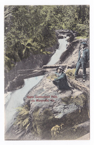
Postcard (item) - Colour tinted postcard, Victorian Stamp Market, Upper Cumberland Falls, via Marysville, Vic, 1908
An early colour tinted photograph of the Upper Cumberland Falls near Cambarville in Victoria. This postcard was published by Victorian Stamp Market as a souvenir of Marysville. An early colour tinted photograph of the Upper Cumberland Falls near Cambarville in Victoria. These falls are located on the Marysville-Wood's Point Road. Cambarville is notable for its giant mountain ash (Eucalyptus regnans) trees within the Cumberland Memorial Scenic Reserve, and relics from former sawmills and gold mining. The Big Culvert is located nearby on the Marysville - Woods Point Road, which was historically part of the Yarra Track. Cambarville was established as a timber mill town in the 1940s. Timber mill owners A Cameron and FJ Barton named Cambarville. They established the mill to salvage timber from trees destroyed in the 1939 bushfires. Cambarville was impacted by the 2009 Black Saturday bushfires and any remaining structures were destroyed.POST CARD This space may be used for Correspondence. FOR ADDRESS ONLY Printed in Germany V.S.M. Seriescumberland falls, cambarville, marysville, victoria, waterfalls, postcard, souvenir, mountain ash, mining, timber mills, big culvert, yarra track, a cameron, fj barton, black saturday bushfires, 1939 bushfires, eucalyptus regnans, victorian stamp market, victorian stamp market series -
 Marysville & District Historical Society
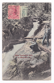
Postcard (item) - Colour tinted postcard, Victorian Stamp Market, Upper Cumberland Falls via Marysville, Vic, 1908
An early colour tinted photograph of the Upper Cumberland Falls near Cambarville in Victoria. This postcard was published by Victorian Stamp Market as a souvenir of Marysville. An early colour tinted photograph of the Upper Cumberland Falls near Cambarville in Victoria. These falls are located on the Marysville-Wood's Point Road. Cambarville is notable for its giant mountain ash (Eucalyptus regnans) trees within the Cumberland Memorial Scenic Reserve, and relics from former sawmills and gold mining. The Big Culvert is located nearby on the Marysville - Woods Point Road, which was historically part of the Yarra Track. Cambarville was established as a timber mill town in the 1940s. Timber mill owners A Cameron and FJ Barton named Cambarville. They established the mill to salvage timber from trees destroyed in the 1939 bushfires. Cambarville was impacted by the 2009 Black Saturday bushfires and any remaining structures were destroyed.POST CARD This space may be used for Correspondence. FOR ADDRESS ONLY Printed in Germany V.S.M. Series WOOD / VICT/ A/ 10 -4.S.10-3/ DISTRIBUZIONS JWO Gricardi/ Via Galletti/ V 16/ Loruis/ Italy Mary A????/ Australiacumberland falls, cambarville, marysville, victoria, waterfalls, postcard, souvenir, mountain ash, mining, timber mills, big culvert, yarra track, a cameron, fj barton, black saturday bushfires, 1939 bushfires, eucalyptus regnans, victorian stamp market, victorian stamp market series -
 Marysville & District Historical Society
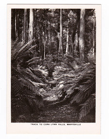
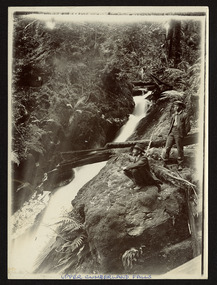
Photograph (item) - Black and white photograph, Rose Stereograph Company, Track to Cora Lynn Falls, Marysville, 1913-1967
An early black and white photograph of the track to the Cora Lynn Falls near Marysville, Victoria.An early black and white photograph of the track to the Cora Lynn Falls near Marysville in Victoria. These falls are located on the Marysville-Wood's Point Road. Cambarville is notable for its giant mountain ash (Eucalyptus regnans) trees within the Cumberland Memorial Scenic Reserve, and relics from former sawmills and gold mining. The Big Culvert is located nearby on the Marysville - Woods Point Road, which was historically part of the Yarra Track. Cambarville was established as a timber mill town in the 1940s. Timber mill owners A Cameron and FJ Barton named Cambarville. They established the mill to salvage timber from trees destroyed in the 1939 bushfires. Cambarville was impacted by the 2009 Black Saturday bushfires and any remaining structures were destroyed. The photograph was also used to produce the Rose Series postcard P. 4958.marysville, victoria, photograph, cora lynn falls, waterfalls, p. 4958, rose series postcard, rose stereograph company, souvenir, cambarville, marysville-wood's point road, eucalyptus regnans, cumberland memorial scenic reserve, mining, big culvert, yarra track, a cameron, fj barton, 1939 bushfires, 2009 black saturday bushfires, timber mills -
 Marysville & District Historical Society
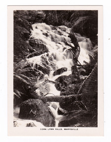
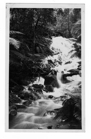
Photograph (item) - Black and white photograph, Rose Stereograph Company, Cora Lynn Falls, Marysville, 1913-1967
An early black and white photograph of the Cora Lynn Falls near Marysville in Victoria.An early black and white photograph of the Cora Lynn Falls near Marysville in Victoria. These falls are located on the Marysville-Wood's Point Road. Cambarville is notable for its giant mountain ash (Eucalyptus regnans) trees within the Cumberland Memorial Scenic Reserve, and relics from former sawmills and gold mining. The Big Culvert is located nearby on the Marysville - Woods Point Road, which was historically part of the Yarra Track. Cambarville was established as a timber mill town in the 1940s. Timber mill owners A Cameron and FJ Barton named Cambarville. They established the mill to salvage timber from trees destroyed in the 1939 bushfires. Cambarville was impacted by the 2009 Black Saturday bushfires and any remaining structures were destroyed. The photograph was also used to produce the Rose Series postcard P. 4947.marysville, victoria, photograph, cora lynn falls, waterfalls, rose series postcard, rose stereograph company, souvenir, cambarville, marysville-wood's point road, eucalyptus regnans, cumberland memorial scenic reserve, mining, big culvert, yarra track, a cameron, fj barton, 1939 bushfires, 2009 black saturday bushfires, timber mills, p. 4947 -
 Marysville & District Historical Society
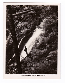
Photograph (item) - Black and white photograph, Rose Stereograph Company, Cumberland Falls, Marysville, 1913-1967
An early black and white photograph of Cumberland Falls near Marysville in Victoria.An early black and white photograph of Cumberland Falls near Marysville in Victoria. These falls are located on the Marysville-Wood's Point Road. Cambarville is notable for its giant mountain ash (Eucalyptus regnans) trees within the Cumberland Memorial Scenic Reserve, and relics from former sawmills and gold mining. The Big Culvert is located nearby on the Marysville - Woods Point Road, which was historically part of the Yarra Track. Cambarville was established as a timber mill town in the 1940s. Timber mill owners A Cameron and FJ Barton named Cambarville. They established the mill to salvage timber from trees destroyed in the 1939 bushfires. Cambarville was impacted by the 2009 Black Saturday bushfires and any remaining structures were destroyed. The photograph was also used to produce the Rose Series postcard P. 2328.marysville, victoria, photograph, waterfalls, cumberland falls, p. 2328, rose series postcard, souvenir, rose stereograph company, cambarville, marysville-wood's point road, mountain ash, eucalyptus regnans, cumberland memorial scenic reserve, mining, timber milling, big culvert, a cameron, fj barton, black saturday bushfires -
 Marysville & District Historical Society
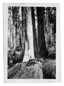
Photograph (item) - Black and white photograph, 10-1947
An early black and white photograph taken in the Cumberland Valley near Marysville in Victoria.An early black and white photograph taken in the Cumberland Valley near Marysville in Victoria. The Cumberland Valley is near Cambarville which was a timber town near Marysville. Cambarville is notable for its giant mountain ash (Eucalyptus regnans) trees within the Cumberland Memorial Scenic Reserve, and relics from former sawmills and gold mining. The Big Culvert is located nearby on the Marysville - Woods Point Road, which was historically part of the Yarra Track. Cambarville was established as a timber mill town in the 1940s. Timber mill owners A Cameron and FJ Barton named Cambarville. They established the mill to salvage timber from trees destroyed in the 1939 bushfires. Cambarville was impacted by the 2009 Black Saturday bushfires and any remaining structures were destroyed.Among Tall Timber at/ Cumberland Valley. Oct.47. 39cumberland valley, marysville, victoria, cumberland creek, mountain ash, timber mill, mining, a cameron, fj barton, cambarville, big culvert, yarra track, black saturday bushfires, 1939 bushfires, photograph -
 Marysville & District Historical Society
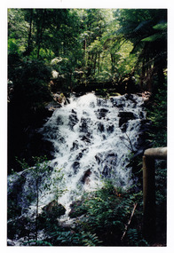
Photograph (item) - Colour photograph, Unknown
A colour photograph of the Cora Lynn Falls near Marysville in Victoria.A colour photograph of the Cora Lynn Falls near Marysville in Victoria. These falls are located on the Marysville-Wood's Point Road. Cambarville is notable for its giant mountain ash (Eucalyptus regnans) trees within the Cumberland Memorial Scenic Reserve, and relics from former sawmills and gold mining. The Big Culvert is located nearby on the Marysville - Woods Point Road, which was historically part of the Yarra Track. Cambarville was established as a timber mill town in the 1940s. Timber mill owners A Cameron and FJ Barton named Cambarville. They established the mill to salvage timber from trees destroyed in the 1939 bushfires. Cambarville was impacted by the 2009 Black Saturday bushfires and any remaining structures were destroyed.marysville, victoria, photograph, cora lynn falls, waterfalls, cambarville, marysville-wood's point road, eucalyptus regnans, cumberland memorial scenic reserve, mining, big culvert, yarra track, a cameron, fj barton, 1939 bushfires, 2009 black saturday bushfires, timber mills -
Marysville & District Historical Society
Article (item) - Magazine article, Emily Friedel, The Cumberland Walk, 06-2022
A magazine article relating to The Cumberland Walk.A magazine article relating to The Cumberland Walk. The Cumberland Valley is near Cambarville which was a timber town near Marysville. Cambarville is notable for its giant mountain ash (Eucalyptus regnans) trees within the Cumberland Memorial Scenic Reserve, and relics from former sawmills and gold mining. The Big Culvert is located nearby on the Marysville - Woods Point Road, which was historically part of the Yarra Track. Cambarville was established as a timber mill town in the 1940s. Timber mill owners A Cameron and FJ Barton named Cambarville. They established the mill to salvage timber from trees destroyed in the 1939 bushfires. Cambarville was impacted by the 2009 Black Saturday bushfires and any remaining structures were destroyed.cumberland walk, cambarville picnic area, big tree, cora lynn falls, cumberland falls, cumberland falls lookout, cumberland valley, marysville-wood's point road, a cameron, fj barton, cambarville, 2009 black saturday bushfires -
 Marysville & District Historical Society
Photograph (item) - Black and white photograph, 1935
An early black and white photograph of the Cora Lynn Falls near Cambarville in Victoria.An early black and white photograph of the Cora Lynn Falls near Cambarville in Victoria. These falls are located on the Marysville-Wood's Point Road. Cambarville is notable for its giant mountain ash (Eucalyptus regnans) trees within the Cumberland Memorial Scenic Reserve, and relics from former sawmills and gold mining. The Big Culvert is located nearby on the Marysville - Woods Point Road, which was historically part of the Yarra Track. Cambarville was established as a timber mill town in the 1940s. Timber mill owners A Cameron and FJ Barton named Cambarville. They established the mill to salvage timber from trees destroyed in the 1939 bushfires. Cambarville was impacted by the 2009 Black Saturday bushfires and any remaining structures were destroyed.marysville, victoria, photograph, cora lynn falls, waterfalls, cambarville, marysville-wood's point road, eucalyptus regnans, cumberland memorial scenic reserve, mining, big culvert, yarra track, a cameron, fj barton, 1939 bushfires, 2009 black saturday bushfires, timber mills -
 Marysville & District Historical Society
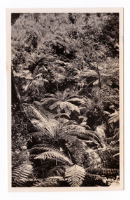
Photograph (item) - Black and white photograph, Valentine Publishing Co. Pty. Ltd, Cumberland Gully, Marysville No.5, 1923-1963
An early black and white photograph of Cumberland Gully in the Cumberland Valley in Victoria.An early black and white photograph of Cumberland Gully in the Cumberland Valley in Victoria. This gully is are located near the Marysville-Wood's Point Road. Cambarville is notable for its giant mountain ash (Eucalyptus regnans) trees within the Cumberland Memorial Scenic Reserve, and relics from former sawmills and gold mining. The Big Culvert is located nearby on the Marysville-Woods Point Road, which was historically part of the Yarra Track. Cambarville was established as a timber mill town in the 1940s. Timber mill owners A Cameron and FJ Barton named Cambarville. They established the mill to salvage timber from trees destroyed in the 1939 bushfires. Cambarville was impacted by the 2009 Black Saturday bushfires and any remaining structures were destroyed. cumberland valley, cumberland gully, cambarville, marysville-wood's point road, eucalyptus regnans, cumberland memorial scenic reserve, mining, big culvert, yarra track, a cameron, fj barton, 1939 bushfires, 2009 black saturday bushfires, timber mills -
 Marysville & District Historical Society
Photograph (item) - Black and white photograph, Unknown
An early black and white photograph of the Upper Cumberland Falls in the Cumberland Valley in Victoria.An early black and white photograph of the Upper Cumberland Falls in the Cumberland Valley in Victoria. These falls are located on the Marysville-Wood's Point Road. Cambarville is notable for its giant mountain ash (Eucalyptus regnans) trees within the Cumberland Memorial Scenic Reserve, and relics from former sawmills and gold mining. The Big Culvert is located nearby on the Marysville - Woods Point Road, which was historically part of the Yarra Track. Cambarville was established as a timber mill town in the 1940s. Timber mill owners A Cameron and FJ Barton named Cambarville. They established the mill to salvage timber from trees destroyed in the 1939 bushfires. Cambarville was impacted by the 2009 Black Saturday bushfires and any remaining structures were destroyed.UPPER CUMBERLAND FALLScumberland falls, cambarville, marysville, victoria, waterfalls, postcard, souvenir, mountain ash, mining, timber mills, big culvert, yarra track, a cameron, fj barton, black saturday bushfires, 1939 bushfires, eucalyptus regnans -
 Marysville & District Historical Society
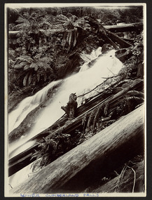
Photograph (item) - Black and white photograph, Unknown
An early black and white photograph of the Lower Cumberland Falls in the Cumberland Valley in Victoria.An early black and white photograph of the Lower Cumberland Falls in the Cumberland Valley in Victoria. These falls are located on the Marysville-Wood's Point Road. Cambarville is notable for its giant mountain ash (Eucalyptus regnans) trees within the Cumberland Memorial Scenic Reserve, and relics from former sawmills and gold mining. The Big Culvert is located nearby on the Marysville - Woods Point Road, which was historically part of the Yarra Track. Cambarville was established as a timber mill town in the 1940s. Timber mill owners A Cameron and FJ Barton named Cambarville. They established the mill to salvage timber from trees destroyed in the 1939 bushfires. Cambarville was impacted by the 2009 Black Saturday bushfires and any remaining structures were destroyed. The photograph was also used to produce the Rose Series postcard P. 2328.LOWER CUMBERLAND FALLSmarysville, victoria, photograph, waterfalls, cumberland falls, p. 2328, rose series postcard, souvenir, rose stereograph company, cambarville, marysville-wood's point road, mountain ash, eucalyptus regnans, cumberland memorial scenic reserve, mining, timber milling, big culvert, a cameron, fj barton, black saturday bushfires -
 Marysville & District Historical Society
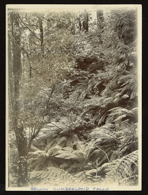
Photograph (item) - Black and white photograph, Unknown
An early black and white photograph of a gully below Cumberland Falls in the Cumberland Valley in Victoria.An early black and white photograph of a gully below Cumberland Falls in the Cumberland Valley in Victoria. These falls are located on the Marysville-Wood's Point Road. Cambarville is notable for its giant mountain ash (Eucalyptus regnans) trees within the Cumberland Memorial Scenic Reserve, and relics from former sawmills and gold mining. The Big Culvert is located nearby on the Marysville - Woods Point Road, which was historically part of the Yarra Track. Cambarville was established as a timber mill town in the 1940s. Timber mill owners A Cameron and FJ Barton named Cambarville. They established the mill to salvage timber from trees destroyed in the 1939 bushfires. Cambarville was impacted by the 2009 Black Saturday bushfires and any remaining structures were destroyed.BELOW CUMBERLAND FALLSmarysville, victoria, photograph, waterfalls, cumberland falls, cambarville, marysville-wood's point road, mountain ash, eucalyptus regnans, cumberland memorial scenic reserve, mining, timber milling, big culvert, a cameron, fj barton, black saturday bushfires -
Marysville & District Historical Society
Flyer (item) - Information flyer, Artworkz Tourism, Marysville-Historic Cambarville, 26-03-2016
A flyer that was produced as a guide to Cambarville near Marysville in Victoria.A flyer that was produced as a guide to Cambarville near Marysville in Victoria. Cambarville is notable for its giant mountain ash (Eucalyptus regnans) trees within the Cumberland Memorial Scenic Reserve, and relics from former sawmills and gold mining. The Big Culvert is located nearby on the Marysville-Woods Point Road, which was historically part of the Yarra Track. Cambarville was established as a timber mill town in the 1940s. Timber mill owners A Cameron and FJ Barton named Cambarville. They established the mill to salvage timber from trees destroyed in the 1939 bushfires. Cambarville was impacted by the 2009 Black Saturday bushfires and any remaining structures were destroyed. cambarville, marysville, victoria, mountain ash, eucalyptus regnans, cumberland memorial scenic reserve, timber milling, big culvert, marysville-woods point road, yarra track, a cameron, fj barton, 2009 black saturday bushfires -
Marysville & District Historical Society
Flyer (item) - Information flyer, Artworkz Tourism, Marysville-Cora Lynn Falls, 20-04-2018
A flyer that was produced as a guide to the Cora Lynn Falls near Marysville in Victoria.A flyer that was produced as a guide to the Cora Lynn Falls near Marysville in Victoria. These falls are located on the Marysville-Wood's Point Road. Cambarville is notable for its giant mountain ash (Eucalyptus regnans) trees within the Cumberland Memorial Scenic Reserve, and relics from former sawmills and gold mining. The Big Culvert is located nearby on the Marysville - Woods Point Road, which was historically part of the Yarra Track. Cambarville was established as a timber mill town in the 1940s. Timber mill owners A Cameron and FJ Barton named Cambarville. They established the mill to salvage timber from trees destroyed in the 1939 bushfires. Cambarville was impacted by the 2009 Black Saturday bushfires and any remaining structures were destroyed.marysville, victoria, photograph, cora lynn falls, waterfalls, cambarville, marysville-wood's point road, eucalyptus regnans, cumberland memorial scenic reserve, mining, big culvert, yarra track, a cameron, fj barton, 1939 bushfires, 2009 black saturday bushfires, timber mills -
Marysville & District Historical Society
Booklet (item) - Information booklet, Artworkz Tourism, Cora Lynn Falls, Unknown
An information booklet that was produced as a guide to the Cora Lynn Falls near Marysville in Victoria.An information booklet that was produced as a guide to the Cora Lynn Falls near Marysville in Victoria. These falls are located on the Marysville-Wood's Point Road. Cambarville is notable for its giant mountain ash (Eucalyptus regnans) trees within the Cumberland Memorial Scenic Reserve, and relics from former sawmills and gold mining. The Big Culvert is located nearby on the Marysville - Woods Point Road, which was historically part of the Yarra Track. Cambarville was established as a timber mill town in the 1940s. Timber mill owners A Cameron and FJ Barton named Cambarville. They established the mill to salvage timber from trees destroyed in the 1939 bushfires. Cambarville was impacted by the 2009 Black Saturday bushfires and any remaining structures were destroyed.marysville, victoria, photograph, cora lynn falls, waterfalls, cambarville, marysville-wood's point road, eucalyptus regnans, cumberland memorial scenic reserve, mining, big culvert, yarra track, a cameron, fj barton, 1939 bushfires, 2009 black saturday bushfires, timber mills -
Marysville & District Historical Society
Flyer (item) - Information flyer, Artworkz Tourism, Marysville-Cumberland Waterfall, Unknown
A flyer that was produced as a guide to the Cumberland Falls near Marysville in Victoria.A flyer that was produced as a guide to the Cumberland Falls near Marysville in Victoria. These falls are located on the Marysville-Wood's Point Road. Cambarville is notable for its giant mountain ash (Eucalyptus regnans) trees within the Cumberland Memorial Scenic Reserve, and relics from former sawmills and gold mining. The Big Culvert is located nearby on the Marysville - Woods Point Road, which was historically part of the Yarra Track. Cambarville was established as a timber mill town in the 1940s. Timber mill owners A Cameron and FJ Barton named Cambarville. They established the mill to salvage timber from trees destroyed in the 1939 bushfires. Cambarville was impacted by the 2009 Black Saturday bushfires and any remaining structures were destroyed.marysville, victoria, photograph, waterfalls, cumberland falls, p. 2328, rose series postcard, souvenir, rose stereograph company, cambarville, marysville-wood's point road, mountain ash, eucalyptus regnans, cumberland memorial scenic reserve, mining, timber milling, big culvert, a cameron, fj barton, black saturday bushfires -
Marysville & District Historical Society
Booklet (item) - Information Booklet, Artworkz Tourism, Cumberland Falls, Unknown
An information booklet that was produced as a guide to the Cumberland Falls near Marysville in Victoria.An information booklet that was produced as a guide to the Cumberland Falls near Marysville in Victoria. These falls are located on the Marysville-Wood's Point Road. Cambarville is notable for its giant mountain ash (Eucalyptus regnans) trees within the Cumberland Memorial Scenic Reserve, and relics from former sawmills and gold mining. The Big Culvert is located nearby on the Marysville - Woods Point Road, which was historically part of the Yarra Track. Cambarville was established as a timber mill town in the 1940s. Timber mill owners A Cameron and FJ Barton named Cambarville. They established the mill to salvage timber from trees destroyed in the 1939 bushfires. Cambarville was impacted by the 2009 Black Saturday bushfires and any remaining structures were destroyed.marysville, victoria, photograph, waterfalls, cumberland falls, p. 2328, rose series postcard, souvenir, rose stereograph company, cambarville, marysville-wood's point road, mountain ash, eucalyptus regnans, cumberland memorial scenic reserve, mining, timber milling, big culvert, a cameron, fj barton, black saturday bushfires