Showing 114 items matching "topographic survey"
-
 Bendigo Military Museum
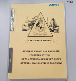
Administrative record - An Error Budget for Products produced by the RASvy Corps, Major Edward J Wright US Army Corps of Engineers, 1988
This document is an analysis determining the positional accuracy (size of errors) within Topographic Mapping Products produced by the Royal Australian Survey Corps.A yellow carboard covered booklet, 2 x "ARNOS" fasteners, Army Survey Regiment Unit emblem designed by SSgt Denis MacCarthy.royal australian survey corps, rasvy, fortuna, army survey regiment, army svy regt, asr -
 Bendigo Military Museum
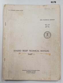
Manual - Shaded Relief Technical Manual - United States Air Force, Department of the Air Force, USA, May 1958
This manual describes how to hand create "Shaded Relief" or the appearance of hills. This manual was produced by the Aeronautical Chart Information Centre, United States Air Force, St Louis 18, Missouri. Shaded relief was produced by hand at the Army Survey Regiment in the 50's, 60's and 70's so that it could be shown on small scale topographical maps and RAAF Aeronauical Charts. Shaded relief continued to be produced by hand until the mid 1980's when it was replaced by digital production methods.Grey covered Manual, gloss paper, stapled together.royal australian survey corps, rasvy, fortuna, army survey regiment, army svy regt, asr -
 Bendigo Military Museum
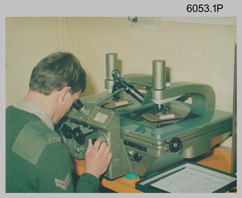
Photograph - Multiplex mechanical stereoplotting equipment, Army Survey Regiment, Fortuna Bendigo, c1950s
This is a set of five photographs of Multiplex mechanical stereoplotting equipment at the Army Survey Regiment, Fortuna Bendigo. c1950s. Multiplex equipment was imported from the UK in 1951 and introduced in the following year, to accelerate map production output covering CMF training areas at 1:25,000 map scale. Multiplex plotting was a productive advancement replacing the ‘Arundel’ method of graphical plotting planimetric detail that was expensive and slow, especially in timbered mountainous terrain. Air photos were made into small diapositives and mounted on racks in the exact position relative to when the aerial photos were taken. The technicians operated the Multiplex in a darkened room, with one photo projected with a green filter and the other through a red filter to form a 3D view of the overlapping photos. The 3D model projected onto a platen, which was a small platform that was raised up and down. The technician viewed the 3D image with special glasses fitted with red and green lenses. In the centre of the platen was a small pinhole that served as a floating mark, with a vertical pencil located exactly below the pinhole. This tracing table was moved to follow the topographic feature or contour line and draw it on the paper underneath. The technician raising or lowering the platform’s floating mark to match the height of the 3D terrain. It also replaced the slotted template method of mechanical adjustment of strips of aerial photography, however was restricted to each strip rather than between strips in the block. Although the Multiplex was phased out of production in 1968, it was used in the training of photogrammetry and aero-triangulation at the School of Military Survey located at Bonegilla, Victoria until the early 1990s. The history of the Multiplex is covered in more detail with additional historic photographs, in pages 50 to 51 of Valerie Lovejoy’s book 'Mapmakers of Fortuna – A history of the Army Survey Regiment’ ISBN: 0-646-42120-4.This is a set of five photographs of Multiplex mechanical stereoplotting equipment at the Army Survey Regiment, Fortuna, Bendigo. c1950s. The photographs were printed on photographic paper and are part of the Army Survey Regiment’s Collection. The photographs were scanned at 300 dpi. .1) - Photo, black & white, c1950s, unidentified personnel operating Multiplex equipment. .2) - Photo, black & white, c1950s, Multiplex equipment. .3) - Photo, black & white, c1950s, Multiplex components identified. .4) - Photo, black & white, c1950s, Multiplex optical components. .5) - Photo, black & white, c1950s. Unidentified technician laying down individual Multiplex plots..1P to .2P, .4P – No annotations. .3P annotations identifying Multiplex components on front of photo. .5P annotated on front ‘Lay down of individual Multiplex plots at 1/14000 to framework of master grid to form Composite Compilation Sheet – Material Duralex.’royal australian survey corps, rasvy, army survey regiment, army svy regt, fortuna, asr, photogrammetry -
 Bendigo Military Museum
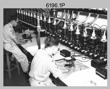
Photograph - Army Survey Regiment Map Production Equipment, c1980s, c1990s
... and photos .3P, .5P to .7P in the c1990s at the Army Survey Regiment... Survey Regiment, Fortuna, Bendigo. Despite lacking annotation ...Photos .1P, .2P, and.4P were most likely taken in the 1980s and photos .3P, .5P to .7P in the c1990s at the Army Survey Regiment, Fortuna, Bendigo. Despite lacking annotation on exact dates, locations and personnel, they are positively identified. CPL Ian Nelson in photo .1P is operating a Wild Pug 4 point transfer device in Air Survey Squadron c1980s. Control points were transferred onto the mapping diapositives of aerial photography by drilling their locations into the photographic emulsion. SPR Viv (Hawkins) Doherty in photo .2P, SPR Jeanette Drury-Lane in photo .5P and SGT Sandy Craig are operating a Wild B8 Stereoplotter coupled to a digital workstation in Air Survey Squadron c1994. Topographic features were extracted with the B8 in 3D and feature coded with attributes, using keyboard, menu, keypad and voice inputs to the computer. The features were stored in the AUTOMAP 2 digital database for subsequent cartographic production and printing. CPL Mick Ellis in photo .3P is operating the Optronix 4040 Scanner/Film Writer in Lithographic Squadron c1990s. In scanning mode, compilation sheets were mounted on the drum and scanned. The resultant raster file was vectorized, feature coded with attributes and stored by cartographic technicians in the AUTOMAP 2 database. In film writing mode, digital cartographic files were output at very high resolution for each print colour on photosensitive film, for subsequent finalisation, platemaking and printing.This is a set of seven photographs of technicians operating map production equipment at the Army Survey Regiment, Bendigo. The photographs were printed on photographic paper and are part of the Army Survey Regiment’s Collection. The photographs were scanned at 300 dpi. .1) - Photo, colour, c1980s. CPL Ian Nelson operating a Wild Pug 4 point transfer device in Air Survey Squadron. .2) - Photo, colour, c1980s. Wild B8 Aviograph stereoplotter feature extraction, SPR Viv (Hawkins) Doherty in Air Survey Squadron. .3) - Photo, colour, c1990s. CPL Mick Ellis operating the Optronics 4040 Scanner in Lithographic Squadron. .4) - Photo, colour, c1984. AUTOMAP 2 Graphic Edit Workstation, SPR Craig Kellet in Cartographic Squadron. .5) - Photo, colour, c1994. Wild B8 Aviograph stereoplotter feature extraction, SPR Jeanette Drury-Lane in Air Survey Squadron. .6) - Photo, colour, c1994. AUTOMAP 2 Graphic Edit Workstation, L to R: unidentified, SPR Rachel (Stanford) Scott, CPL Chris Wynn in Cartographic Squadron. .7) - Photo, colour, c1994. Wild B8 Aviograph stereoplotter AUTOMAP 2 Graphic Edit Workstation, L to R: unidentified (x2), SGT Sandy Craig in Air Survey Squadron..1P – no annotations .2P – annotated “Stereoplotter Workstation. The operator has the use of keyboard, menu, keypad and voice for input to the computer. Feedback is given through voice and screen messages.” .3 to .7P – no annotationsroyal australian survey corps, rasvy, army survey regiment, army svy regt, fortuna, air survey, litho, aerotrig, automap 2 -
 Bendigo Military Museum
Photograph - Photographic Technicians performing tasks at the Army Survey Regiment, c1960s, c1970s
These five photographs were most likely taken in the 1970s in Lithographic Squadron at the Army Survey Regiment, Fortuna, Bendigo. Photos .1P to .3P are annotated with the name of the technicians written on the back. Although Photo .4P is not annotated the technician is positively identified. In these five photos the technician is applying a UV-sensitive pigmented dye emulating one of the print colours to a white opaque polyester sheet mounted on a rotating table in a whirler. The coated sheet was dried before placement in a vacuum light frame beneath a stud registered map negative. They were then exposed to a carbon arc lamp. If there was more than one negative – typical for a type impression or 1st proof, the process was repeated for the other negatives of that print colour. There was a single exposure for composite negatives which was typical for the 2nd and final proof - the pre-press proof. The sheet was removed and washed with water and dried leaving the exposed colour impression. The technician repeated this process using process or spot dyes for remaining publication colours. Type impressions were a combination of the map grid and the topographic features in their correct print colours, forming a base for the cartographer to accurately position map names and symbols on a clear film overlay. The pre-press proof was a cost-effective way of producing a one-off visual copy of the map or chart product. It enabled cartographers to perform a quality inspection and correct any faults before publication. The pre-press proof was deemed authoritative before its release to Print Troop for bulk printing and distribution.This is a set of photographs of lithographic technicians preparing map proofs at the Army Survey Regiment, Bendigo c1960s c1970s. The photographs were printed on photographic paper and are part of the Army Survey Regiment’s Collection. The photographs were scanned at 300 dpi. .1) - Photo, black & white, c1970s, SGT Graham Jeffers, Lithographic Squadron .2) - Photo, black & white, c1970s, SGT Ken Slater Lithographic Squadron .3) - Photo, black & white, c1970s, Ian ‘Loft’ Turner, Lithographic Squadron .4) - Photo, black & white, c1970s, Gary Kerr, Lithographic Squadron .5) - Photo, black & white, c1960s, unidentified, Lithographic Squadron.1 to .3 – personnel names (less rank) annotated on back. .4 to .5P – no annotationroyal australian survey corps, rasvy, army survey regiment, army svy regt, fortuna, asr, litho -
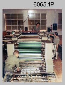 Bendigo Military Museum
Photograph - Ultra-MAN-III Printing Presses operating at the Army Survey Regiment, c1970s to c1980s
These ten photographs of the Ultra-MAN-III Printing Presses were probably taken circa 1970s to 1980s in Lithographic Squadron at the Army Survey Regiment, Fortuna, Bendigo. Although most photos are not annotated except for photos .1, .3P, .6P; most personnel are positively identified. The two Ultra-MAN-III Printing Presses were made in Germany at a standard map size format and introduced in June 1962 as a two-colour offset press with improved safety features. With an upgrade to a third colour deck in 1968, productivity greatly improved as the two presses could print a five colour standard topographic map in two passes, rather than the three passes before their upgrade. They were replaced with a single Heidelberg Speedmaster 102 five colour Printing Press in 1990. c1970s to c1980s.This is a set of photographs of the Ultra-MAN-III Printing Press operational at the Army Survey Regiment, Bendigo c1970s to c1980s. The photographs were printed on photographic paper and are part of the Army Survey Regiment’s Collection. The photographs were scanned at 300 dpi. .1) - Photo, colour, c1970s, L to R: Morgan, Mulqueen, Cook, Lithographic Squadron .2) - Photo, black & white, c1980s, unidentified, Lithographic Squadron .3) - Photo, black & white, c1980s, Ken Slater, Lithographic Squadron .4) - Photo, black & white, c1980s, L to R: Kim Reynolds, Terry Winzar, Lithographic Squadron .5) - Photo, black & white, c1980s, Lithographic Squadron .6) - Photo, black & white, c1980s, L to R: Steve Egan, unidentified, Jim Cook, Lithographic Squadron .7) - Photo, black & white, c1980s, Kim Reynolds, Lithographic Squadron .8) - Photo, black & white, c1980s, Roy Hicks, Lithographic Squadron .9) - Photo, black & white, c1980s, Lithographic Squadron .10) - Photo, black & white, c1980s, Colin Yeats, Lithographic Squadron.1, .3P, .6P – personnel annotated 2P, .4P to .5P, .76P to .10P – no annotation royal australian survey corps, rasvy, army survey regiment, army svy regt, fortuna, asr, printing, litho -
 Bendigo Military Museum
Photograph - New Printing Press, Lithographic Squadron – Army Survey Regiment, Fortuna, Bendigo, 1990
This is a set of 30 photographs of contractors installing the Army Survey Regiment’s new Heidelberg Speedmaster 102 printing press in Lithographic Squadron’s purpose-built printing building at Fortuna, Bendigo in 1990. The computer-controlled five colour lithographic offset printing press provided the Royal Australian Survey Corps vastly improved printing capability, as the five colours for a standard topographic map was printed in a single pass. The print room was named Wayzgoose Hall after a medieval printing house festival. Wayzgoose Hall and the Speedmaster printing capability was commissioned by the Commander of the 3rd Military District BRIG P. Davies AM, ADC on Wednesday 27th June 1990. This occasion is covered in more detail in page 145 of Valerie Lovejoy’s book 'Mapmakers of Fortuna – A history of the Army Survey Regiment’ ISBN: 0-646-42120-4.This is a set of 30 photograph of the Heidelberg Speedmaster 102 Printing Press installation in Lithographic Squadron, Army Survey Regiment at Fortuna, Bendigo, 1990. The photographs were on 35mm colour negative film and were scanned at 96 dpi. They are part of the Army Survey Regiment’s Collection. No personnel are identified. Annotated with date on negative sleeve.royal australian survey corps, rasvy, army survey regiment, army svy regt, fortuna, asr, litho, printing -
 Bendigo Military Museum
Photograph - First Topographic Map Printed on Speedmaster Press - Army Survey Regiment, Fortuna, Bendigo, c1992
... Topographic Map Printed on Speedmaster Press - Army Survey Regiment ...This is a photograph of the Director Survey - COL Simon Lemon, CO Army Svy Regt - LTCOL Bob McHenry and probably OC Litho - MAJ Terry Lord inspecting the 1St topographic map printed on the new Heidelberg Speedmaster 102 Printing Press in c1992. *Estimated date based on the Director’s and CO’s period of appointment. The computer-controlled five colour lithographic offset printing press provided the Royal Australian Survey Corps vastly improved printing capability, as the five colours for a standard topographic map was printed in a single pass. The print room was named Wayzgoose Hall after a medieval printing house festival. Wayzgoose Hall and the Speedmaster printing capability was commissioned by the Commander of the 3rd Military District BRIG P. Davies AM, ADC on Wednesday 27th June 1990. This occasion is covered in more detail in page 145 of Valerie Lovejoy’s book 'Mapmakers of Fortuna – A history of the Army Survey Regiment’ ISBN: 0-646-42120-4. Colonel Simon Lemon was Director of the Royal Australian Survey Corps from January 1991 to June 1996.This is a photograph of three senior RASvy officers inspecting the first topographic map printed on the Heidelberg Speedmaster 102 Printing Press in Lithographic Squadron, Army Survey Regiment, Fortuna, Bendigo, c1992. The photograph is on 35mm black and white negative film and was scanned at 96 dpi. It is part of the Army Survey Regiment’s Collection. No personnel are identified. royal australian survey corps, rasvy, army survey regiment, army svy regt, fortuna, asr -
 Bendigo Military Museum
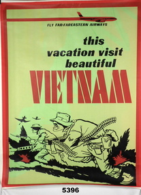
Poster, A Section/Topographical Survey Troop in South Vietnam in the 1960/70's
... A Section/Topographical Survey Troop in South Vietnam in... coloured background. Poster POSTER A Section/Topographical Survey ...Print on Poster " FLY FAR-FAREASTERN AIRWAYS/this /vacation visit/ beautiful/ VIETNAMPoster - white paper, black and red print, illustrated in black and red - stylized picture of two soldiers in a battle. Green and Yellow coloured background.poster, vietnam, travel -
 Bendigo Military Museum
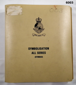
Manual - Symbolisation All Series (Symbas), Specification for maps produced by the Royal Australian Survey Corps, C 1988
Symbas provides the specification (rules) for the collection and compilation of topographic data; the basic instructions for colour preparation and reproduction of topographical detail on maps produced by RASvyPlastic cover, book, beige, 7 chapters, metal clip bindingroyal australian survey corps, rasvy, fortuna, army survey regiment, army svy regt, asr, symbas, specification -
 Bendigo Military Museum
Manual - DRAFT SPECIFICATIONS FOR TOPOGRAPHIC MAP SERIES, Specifications for 1:50000 and 1:25000 maps produced in Australia, Circa 1973
These draft Specifications set out the Standards for the production of topographic maps within the Commonwealth of Australia at scales of 1:50000 and 1:25000 and are designed to satisfy the basic requirements of both civil and military map users.Hard cover, cloth, Red, 11 Annexes, Supplementary documents.royal australian survey corps, rasvy, fortuna, army survey regiment, asr -
 Federation University Historical Collection
Map - Geological, Tallangatta, New South Wales: 1:250,000 Geological Series, SJ 55-3, 1966, 1966
... wales geological survey topographical base snowy mountains hydro ...Compiled by the Geological Survey of N.S.W., Division of Regional Geology. Topographical base compiled from Snowy Mountains Hydro Electrical Authority, Department of Lands, County maps and Snowy Lease Map. Other sheet adjoin this map. There are 13 formation sections grouped into 9 - Quaternary, Tertiary, Middle Devonian, Lower to Middle Devonian, Lower Devonian, Upper Silurian, Silurian, Upper Ordovician and Ordovician.Large coloured map showing geological features, faults, bores, rivers and mineral deposits.Scale of map, longitude and latitude, river names. "Tallangatta 1:250,00" written in black pen.tallangatta, new south wales, geological survey, topographical base, snowy mountains hydro electrical authority, department of lands, snowy lease map, department of mines, quaternary, tertiary, middle devonian, lower to middle devonian, lower devonian, uper siluran, silurian, upper ordovician, ordovician -
 Montmorency–Eltham RSL Sub Branch
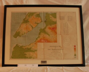
Map - Framed 1915 Map of Krithia, Gallipoli, 1915 Map of Krithia, Gallipolli, 1915
A framed topographical map of The Dardenelles produced from captured Turkish maps by the Egyptian Survey Department. The main feature is the Krithia battlefield area in 1915.Krithia Peninsula (The Dardenelles) World War One - 1915 Mapworld war one, 1915, egypt, map, dardenelles, krithia, survey department, turkey, battlefields -
 Ringwood and District Historical Society
Map, Government Printer, Melbourne, Ringwood Zone Ordinance Survey Map, 1935
Ordinance survey map glued to cheesecloth, of Ringwood zone - Commonwealth topographical map dated 1.8.35, scale 1:63,360. Information correct up to June 1922. "Ringwood 81" printed on the reverse side.; Envelope and note from donor of item, with return letter of appreciation from Ringwood & District Historical Society dated 20-May-2005. +Additional Keywords: Reid, Don -
Federation University Historical Collection
Map, Topographical Map Creswick A & B
Printed map on papercreswick, clunes, lexton, waubra, smeaton -
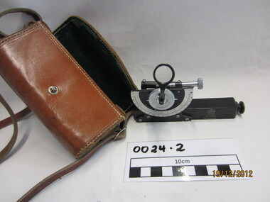 Wannon Water
Clinometre / Abney Level, E. R. Watts & Son, Clinometre
... Abney Level / Clinometer is an accurate surveying tool used ...Abney Level / Clinometer is an accurate surveying tool used to measure degrees, percent of grade and topographic elevation. Used for surveying pipe lines.Instrument which consists of a fixed sighting tube, a movable spirit level connected to a pointing arm which turns and pivots. Adjustment knob/screw on top turns to rotate the compass indicator and bubble level. Arched scale graduated 0 to 90 degrees in both directions. Clinometer is housed in a brown leather case with a long leather strap for carrying around the neck.Watts London / No 70131 / Made in England -
 National Vietnam Veterans Museum (NVVM)
Photograph, Behind the Wire
... 1st Topographical Survey Troop... the Wire Noel Sproles Nui Dat 1st Topographical Survey Troop Black ...Black and white photograph of Noel Sproles, Troop Second In Command, Nui Datphotograph, behind the wire, noel sproles, nui dat, 1st topographical survey troop -
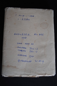 Anglesea and District Historical Society
Map, Royal Australian Survey Corps, Anglesea, Victoria, 1954
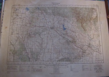
Anglesea, Victoria [cartographic material] produced by Royal Australian Survey Corps. Colour; Scale [1:63,360] 1 mile to 1 inch; transverse Mercator projection; Sheet No. 866, Zone 7. Two stamps: 1. Rankine and Dobbie Pty Ltd. 2. Authorised for sale / Price 2/- / By Department of the Army Original date: November 1928.(See above)anglesea map, topographic map -
Victorian Aboriginal Corporation for Languages
Map, Geographic Data Victoria, Vicmap topographic map index as at June 2000, 2000
Index to Vicmap topographic mapping, including 1:25 000 and 1:50 000 topographic maps, and Outdoor leisure series, compiled by the earlier bodies, Survey &? Mapping Victoria, etc. Also indexes Royal Australian Survey Corps' 1:50 000 topographic mapping.mapsvictorian maps, topographic maps -
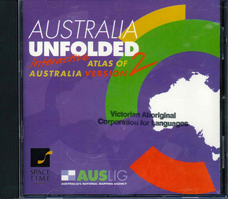 Victorian Aboriginal Corporation for Languages
CD-ROM, Australian Surveying and Land Information Group, Australia unfolded : interactive atlas of Australia, 1996
... Street Brunswick melbourne topographic maps Australian maps ...Systems requirements: Macintosh version: Mac Plus (68030 or higher recommended), 5 MB hard disk space, 2 MB RAM (4 MB RAM recommended), CD-ROM drive, mouse, System 7 or above. "9314231106006"--CD-ROM. System requirements: Windows version: IBM compatible 386 or higher, 5MB hard disk space, 4MB RAM (8MB RAM recommended), VGA monitor, CD-ROM drive, mouse, Windows 3.1 or above. In box (19 x 27 x 5 cm.).CD-ROMtopographic maps, australian maps, surveying -
Creswick Campus Historical Collection - University of Melbourne
Still Image, 1952
Subject: King Lake . 6 brown envelopes marked Run 3, 4, 7, 7a, 8, 9 containing c. 80 prints. 1 section of a topographical map marked State Aerial Survey. Stored in a brown cardboard file box marked King Lake Run No.3 - 9. (x9). Photos commissioned by Forests Commission Victoria.Aerial Photographs -
 Ballarat Tramway Museum
Map, Australian Survey Corps, "Victoria Ballan", 1933
Topographic map of the Ballan area - includes Bacchus Marsh and Bungaree, No. 837, Zone 7, Army Map, dated 1933, 1:63360. Shows rail lines, roads, elevations, contours. Collected with relevance to the Museum's association with the area, at Bungareetrams, tramways, bungaree, map -
Beechworth Honey Archive
Topographic Map, Beechworth, Australia
Map 1:50,000. Sheet 8225-111 Printed by Royal Australian Survey Corp, 1967. Map includes Beechworth, Everton, Muirmungee, Wooragee and Eldorado. -
 Department of Energy, Environment and Climate Action
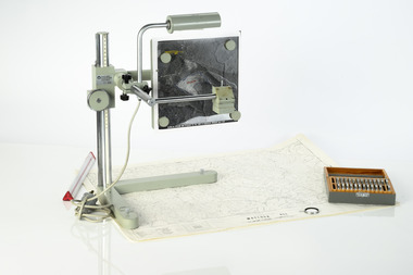
Zeiss Sketchmaster
The Zeiss Sketchmaster was used to transfer information from aerial photographs onto scale maps. The operator views the aerial photograph and the map simultaneously and manually traces detail from the photograph onto the map. It utilises the principle of the camera lucida, patented in 1806. Various lens combinations were used on a to adjust for scale and then “rubber sheet” the image to line up topographic features like streams and roads. The photo information was then laboriously transferred using a light table onto large A0 paper maps or translucent drafting film. The maps were later hand coloured with either Derwent pencils or delicately painted with Pelikan ink wash. This item is kept at Erica.Zeiss Sketchmaster. c1970s. Includes adjustable stand, various lens in sperate box, adjustable light, map holder and magnetsforests commission victoria (fcv), forest measurement, mapping, surveying -
 Bendigo Military Museum
Photograph - 4th Field Survey Squadron deployed on Operation NERIGHT, Queensland & Northern Territory, 1989
This is a set of 19 photographs taken in 1989 during 4th Field Survey Squadron’s deployment on Operation NERIGHT 89 in Queensland and the Northern Territory. It was a two-part operation in 1989 with work conducted in the areas of Camooweal and Weipa. Part 1 was the field completion of topographic maps conducted near Camooweal QLD, along the Barkley Highway on the border between NT and QLD, from the 12th of September to the 20th of October 1989. A Bell Kiowa LOH helicopter from 162 Recce Sqn supported topographic field completion. Operation NERIGHT 89 Part 2 was the acquisition of mapping control by GPS field parties utilising Texas Instruments TI4100 Global Positioning System receivers around Weipa on Cape York Peninsula from the 22nd of September to the 22nd of October 1989. Part 2 Two Bell UH-1H Iroquois helicopters from RAAF’s 35 Squadron were principally used to deploy GPS field parties. Identification photography of control points was taken by air camera operators in AAAvn Pilatus Porter aircraft from 173 Gen Spt Sqn fitted with an RC10 aerial camera. The two parts of the operation were conducted concurrently. This is a set of 19 photographs taken in 1989 during 4th Field Survey Squadron’s deployment on Operation Neright in Queensland & the Northern Territory. The colour photographs are on 35mm negative film and are part of the Army Survey Regiment’s Collection. The photographs were scanned at 96 dpi. .1) to .3) - Photo, colour, 1989. En-route to areas of survey operations. .4) to .5) - Photo, colour, 1989. Unidentified personnel relax next to river/waterhole. .6) - Photo, colour, 1989. Two Bell UH-1H Iroquois helicopters from RAAF’s 35 SQN utilised in the movement of GPS parties. .7) to .9) - Photo, colour, 1989. Unidentified soldier practices repelling from a UH1H Iroquois helicopter. .10) - Photo, colour, 1989. Inside the cockpit of a UH1H Iroquois helicopter. .11) - Photo, colour, 1989. Field Party camp with GPS equipment in foreground. Unidentified soldier prepares a meal. .12) - Photo, colour, 1989. GPS antenna plumbed over a survey ground mark. Witness post on left. .13) & .14) - Photo, colour, 1989. Unknown Cape York Peninsula beaches. .15) & .16) - Photo, colour, 1989. Dramatic fire next to base camp. .17) - Photo, colour, 1989. Aboriginal rock art at unknown location. .18) - Photo, colour, 1989. Aboriginal rock art at unknown location. L to R: unidentified, SPR Andrew Quin. .19) - Photo, colour, 1989. Aboriginal rock art at unknown location. LT Chris Topovsek..1P to .19P – There are no personnel identified. ‘1989 OP NERIGHT’ annotated on negative sleeve.royal australian survey corps, rasvy, 4 fd svy sqn, op neright 89 -
 Bendigo Military Museum
Photograph - 4th Field Survey Squadron – Operation ARIGHT 93, Queensland, 1993
This is a set of 42 photographs taken during 4th Field Survey Squadron’s deployment on Operation ARIGHT 93 in North Queensland from the 30th of August to the 8th of October 1993. The Survey Field Completion area of operations was Weipa near the top end of the Cape York Peninsula. Survey parties conducted field checking of topographic maps covering Bamaga, Heathlands, Weipa, Lockhart River and Strathgordon in Perentie 110 Series Survey variant FFR Land Rovers. Hand-held Trimble and Magellan GPS receivers were used to assist with navigation and to position remote isolated features. Three Bell Kiowa LOH helicopters provided by 162 Recce Sqn supported field checking operations. Supplementary and Vital Asset Protection photography was taken by air camera operators in AAAvn Nomad aircraft from 173 Survl Sqn fitted with an RC10 aerial camera.This is a set of 42 photographs taken in 1993 durin8g 4th Field Survey Squadron’s deployment on Operation ARIGHT in North Queensland. The colour photographs are on 35mm negative film and are part of the Army Survey Regiment’s Collection. The photographs were scanned at 96 dpi. .1) - Photo, colour, 1993. Survey party in Perentie 110 Series Land Rover navigates through Cape York Peninsula sand hills. .2) - Photo, colour, 1993. Cape York Peninsula sand hills. .3) - Photo, colour, 1993. Cape York Peninsula Island. .4) - Photo, colour, 1993. Survey party in Perentie 110 Series Land Rover enters a Cape York Peninsula beach. .5) - Photo, colour, 1993. SPR Kim Baker takes a break on a Cape York Peninsula beach. .6) - Photo, colour, 1993. L to R: MAJ Andy Cordova (USA Exchange) from the Army Survey Regiment and unidentified civilians. .7) to .14) - Photo, colour, 1993. Cape York Peninsula topography. .15) - Photo, colour, 1993. Unidentified surveyor in Bell Kiowa LOH helicopter. .16) - Photo, colour, 1993. Bell Kiowa LOH helicopter circles base camp. .17) to .18) - Photo, colour, 1993. Cape York Peninsula topography. .19) - Photo, colour, 1993. Vehicle convoy taking a break. L to R: LT John Bath (Detachment OC), unidentified (x2), SPR Chris Pearse. .20) - Photo, colour, 1993. Vehicle convoy taking a break. .21) - Photo, colour, 1993. Vehicle convoy ready to go. SPR Chris Pearse. .22) - Photo, colour, 1993. Vehicle convoy on the move. .23) - Photo, colour, 1993. Cape York Peninsula topography. .24) - Photo, colour, 1993. Unidentified personnel. .25) - Photo, colour, 1993. SGT Neale ‘Tex’ Houston. .26) - Photo, colour, 1993. Ground below a Bell Kiowa LOH helicopter .27) - Photo, colour, 1993. L to R: SPR Mark Sinderberry and CPL Stuart Adrain in a Bell Kiowa LOH helicopter. .28) & .29) - Photo, colour, 1993. Ground below a Bell Kiowa LOH helicopter. .30) - Photo, colour, 1993. Base camp viewed from a Bell Kiowa LOH helicopter. .31) - Photo, colour, 1993. Cape York Peninsula topography in recovery after burn-off. .32) & .33) - Photo, colour, 1993. SPR Kim Baker contemplates crossing this bridge in his Land Rover. .34) - Photo, colour, 1993. SPR Kim Baker takes a break next to a billabong. .35) - Photo, colour, 1993. Survey party in Perentie 110 Series Land Rover crosses a creek. .36) - Photo, colour, 1993. Cape York Peninsula bush fire in distance. .37) - Photo, colour, 1993. Survey party in Perentie 110 Series Land Rover traverses a sand hill. .38) - Photo, colour, 1993. SPR Kim Baker. .39) - Photo, colour, 1993. Cape York Peninsula bush fire. .40) - Photo, colour, 1993. Cape York Peninsula topography. .41) & .42) - Photo, colour, 1993. Cape York Peninsula sand hills..1P to .42P – There are no personnel identified. ‘1993 OP ARIGHT’ annotated on negative sleeve.royal australian survey corps, rasvy, 4 fd svy sqn, op aright 93 -
 Bendigo Military Museum
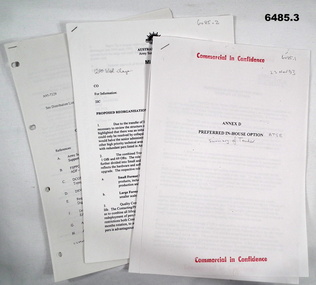
Document - Army Topographic Support Establishment: Preferred In-House Option, 1 23 Nov 1993, .2 30 Nov 1994, .3 14 Jun 1995
.1 The Preferred In-House Option (PIHO) proposes to meet the full requirements of the Request for Tender (RFT) by disestablishing Army Survey Regiment and establishing a new organisation which they have named the Defence Topographic Support Establishment (DTSE). It is proposed to locate the DTSE at Bendigo in the GFE facilities offered by the Commonwealth. The DTSE will be staffed by 140 Defence civilians, principally sourced from ex-RASvy members transferring to the Public Service under the provisions of Section 81B of the Public Service Act. Any existing civilian members excess to DTSE requirements are proposed to be managed within the terms and conditions of the Australian Public Service Redeployment and Retirement (Redundancy) Award 1987. Military members who elect to remain in the Service will be subject to redeployment or retraining in accordance with Service requirements. .2 Proposed re-organisation of Product Construction Squadron (PCS). Due to the transfer of Image and capture Sections to Digital Acquisition Squadron wef Jan 1995 it has been necessary to review the structure of those elements remaining within PCS. The review highlighted that there was an imbalance between Mapping and Digital products Troops. This could only be resolved by collapsing these two Troops into one single production element. This would halve the senior administrative personnel needed thus allowing them to be employed in other higher priority technical areas. The proposed restructure of PCS is outlined in Annex A with redundant personnel listed in Annex B. The combined Troop is to be designated "Construction Troop" and comprises 1 Offr and 69 ORs. The role of this Tp would be to perform all digital production. It is further divided into small and Large Format Sections. This division is functionally based and reflects the hardware and software configurations now resident within the Sqn post system upgrade. .3 During the transition period leading to full implementation of the PHIO, the Army Svy Regt and DTSE (later ATSE) will at times operate concurrently whilst Army Svy Regt scales down production and progressively transfers all technical functions to DTSE. army Svy Regt and 4 Fd Svy Sqn will continue programmed production activities until declared operationally ineffective, however a contingency mapping capability will be maintained throughout the period of implementation. Implementation of the PHIO involves a number of related activities including staff recruitment, equipment acquisition and transfer of technical responsibility. This instruction details the coordination of these and related implementation activities. .1 Preferred In-House Option, Army Topographic Support Establishment. Summary of Tender. 10 x pages typed text and schematic diagrams. .2 Proposed reorganisation - product Construction Squadron. 9 x pages typed text and schematic diagrams. .3 Implementation of the Commercial Support Program (CSP) Digital Topographical support to the Australian Defence Force (ADF). Preferred In-House Option 14 Jun 1995. 22 x pages typed text and schematic diagrams. royal australian survey corps, rasvy, fortuna, army svy reg, army survey regiment, atse -
 Bendigo Military Museum
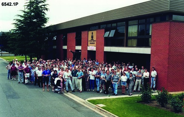
Photograph - 4 Fd Svy Sqn Closure Ceremony 25 Nov 1995, 4 Fd Svy Sqn, Keswick Barracks, Adelaide, 25.11.1995
Between 1915 and 1951, military topographical mapping in SA was conducted by Royal Australian Survey Corps (RASvy) units based outside the state. In February 1952, Army HQ Field Survey Section (Central Command Detachment) was established in Adelaide in a drill hall at Largs Bay. It was tasked with providing map coverage in the Woomera and Southern areas of the state. The section was subsequently reorganised as Central Command Field Survey Section moving firstly to Hampstead Barracks, Hampstead in 1953 and then into accommodation at Keswick Barracks in 1954. In 1957 the Section commenced mapping operations in the NT. The Unit was relocated to the old cavalry stables in 1961 and was redesignated Central Command Survey Unit and remained there till 1973. In 1970 the Unit was redesignated 4 Fd Svy Sqn and engaged in operations conducted in PNG from 1972 to 1974 inclusive. In 1973 the Squadron moved into a brand new two-storey specially designed and purpose built building adjacent to the old building. The old building then became the Squadron Q and Map store with an interconnecting lobby to the new building. Since 1975 the Unit was involved in the 1:50,000 Mapping Programme in WA, NT, QLD, SA and conducted many other operations within Australia and overseas. Post disbandment of the Corps the old Squadron building (cavalry stables) now houses the Army Museum of South Australia (AMOSA). The Royal Australian Survey Corps was amalgimated into the Royal Australian Engineer Corps in July 1996. In the lead up to this amalgamation, 4 Field Survey Squadron Keswick Barracks, Adelaide, South Australia was disbanded in 1995. A closing Ceremony was held on 25 November 1995 at 4 Fd Svy Sqn Keswick Barracks attended by about 208 former members of the Unit. A photo was taken of attendees at that event on the day and a list was prepared of attendees. All attendees were sent a copy of the photograph and the list of names as a momento of the Unit and the ceremony..1P A4 Print of an original photo of attendees at the 4 Fd Survey Sqn Closure Ceremony at Keswick Barracks 25 Nov 1995. .2P A4 Print of the names of the attendees at the 4 Fd Survey Sqn Closure Ceremony at Keswick Barracks 25 Nov 1995. Approx 208 attendees.royal australian survey corps, rasvy, fortuna, army survey regiment, army svy regt, asr, 4 fd svy sqn -
 Bendigo Military Museum
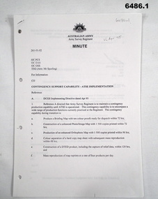
Document - Contingency Support Capability - Army Topographic Support Establishment (ATSE) Implementation, Army Survey Regiment, Bendigo, Apr - Jun 1995
.1 The Minute details that the Army Survey Regiment is maintain a contingency production capability until ATSE is operational. .2 The Minute details the Data Aquisition Squadron requirements during the Implementation to ATSE. .3 The Minute details the Hardware, Software, Personnel and skills required during Implementation to ATSE. .4 The Instruction details that the non-core mapping, charting and geodetic (MC&G) activities of the Army Survey Regiment and 4 Fd Svy Sqn were tested under the Commercial Support Program (CSP) process resulting in the decision to award the contract for the provision of non-core mapping services to the ADF to the Preferred In-House Option (PIHO). .1 Contingency Support Capability - Army Topographic Support Establishment (ATSE) Implementation 26 Apr 95 (11 x A4 pages) .2 Data Acquisition Squadron (DAS) Contingency Support Capability - Army Topographic Support Establishment (ATSE) Implementation Apr 95 (4 x A4 Pages) .3 Contingency Support Capability - Army Topographic Support Establishment (ATSE) Implementation 28 Apr 95 (9 x A4 pages) .4 Directorate of Military Survey - Army Instruction for Implementation of the Army Topographic Support Establishment (ATSE) Jun 95 (10 x A4 pages)royal australian survey corps, rasvy, fortuna, army survey regiment, army svy regt, asr, atse -
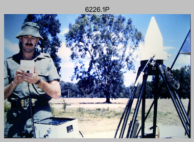 Bendigo Military Museum
Photograph - Demonstration of TI4100 GPS Receiver, Royal Australian Survey Corps, c1988
This is a set of four photographs of WO2 Graham Ragless from the Royal Australian Survey Corps demonstrating the operation of Global Positioning System equipment in c1988. The photos were probably taken at the School of Military Survey (SMS), Bonegilla, VIC. Texas Instruments TI4100 portable Global Positioning System (GPS) geodetic receivers were introduced from 1986–1988. The GPS receivers and Ferranti FILS3 helicopter and vehicle mounted Inertial Positioning System (IPS) replaced the TRANSIT satellite receivers. The equipment was deployed to establish the baseline for a GPS controlled air camera and photogrammetric system to significantly reduce the requirement for ground survey to accurately control air photography for topographic mapping. Personnel from the four field survey squadrons at this time were trained at the SMS to operate the TI4100 receivers. Field survey operations using GPS and IPS equipment followed in the late 1980s. This technology is described in more detail in the RA Svy booklet titled An Introduction to Topographic Mapping. See record ID - 6010. WO2 Graham Ragless progressed to the rank of WO1 and was appointed as RSM of the Army Survey Regiment from 1990 to 1992. Refer to item 6186.2P for more photographs of WO2 Graham Ragless demonstrating the TI4100.This is a set of four photographs of a technician from the Royal Australian Survey Corps demonstrating the operation of Global Positioning System equipment in c1988. Colour photos are on 35mm slide film and were scanned at 96 dpi. .1) to .4) - Photo, colour, c1988, WO2 Graham Ragless demonstrating the operation of a TI4100 GPS receiverThere are no annotations.royal australian survey corps, rasvy, army survey regiment, army svy regt, fortuna, asr, surveying