Showing 2474 items
matching township
-
 Whitehorse Historical Society Inc.
Document, Blackburn Township Estate, 1910
Auction of 124 lots of the Blackburn Township Estate on Saturday 19th November 1910,Auction of 124 lots of the Blackburn Township Estate on Saturday 19th November 1910,Auction of 124 lots of the Blackburn Township Estate on Saturday 19th November 1910,blackburn township estate, 124 lots -
Whitehorse Historical Society Inc.
Document, Virtual Vermont - Norwich Township, 2015
A draft copy of a book on the history of the failed Norwich Township proposal in Vermont 1858.A draft copy of a book on the history of the failed Norwich Township proposal in Vermont 1858.A draft copy of a book on the history of the failed Norwich Township proposal in Vermont 1858.norwich village vermont, proposed -
 Whitehorse Historical Society Inc.
Article, Blackburn A Model Township, 1880's
During the boom years of the 1880's, the new township of Blackburn was designed and built.During the boom years of the 1880's, the new township of Blackburn was designed and built.During the boom years of the 1880's, the new township of Blackburn was designed and built.blackburn, gardiner's creek, blackburn lake, freehold investment and banking company of australia ltd, goodwin, george augustus -
 Ballarat Heritage Services
Photograph - digital images, L.J. Gervasoni, Cocoroc township - Werribee farm, 2011
Colour digital images images showing the former township of Cocoroc, Werribee farmcocoroc, town, shed, werribee farm, mmbw, melbourne metropolitan board of works, settlement, farm -
 Ringwood and District Historical Society
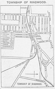
Photograph, Directory of Ringwood Township, from Sands and McDougall Directory - 1905. (New Street is incorrectly shown as Heatherdale Road on this map. Heatherdale Road's actual location is to the east, beyond the top of the map perimeter.)
Catalogue card reads, 'Directory of Ringwood Township - 1905. From Sands and McDougall Directory.' -
Ringwood and District Historical Society
Literary work - Envelope, Packet: Percydale - small mining township - history written by Betty Austin of Ringwood (June 1966)
Percydale - small mining township - history written by Betty Austin, Kendall Street Ringwood -
Port Melbourne Historical & Preservation Society
Document, "The Township of Sandridge 1860 Names of Lot Owners", 1990s
Six foolscap pages listing the names of the lot owners in 1860 in the township of Sandridge: Handwrittenbuilt environment -
 Peterborough History Group
Map - Map of the town, Government Printer, Township of Peterborough
Map donated by Barry Jenkins and assume that updated names were written on the map by him. Good information pertaining to the history of each allotment. Significant as it shows the names of the owners of each allotment in 1931 and handwritten notes of more recent owners.27/6/1931 paper map of the township of Peterborough including names of the landowners at that time.Handwritten landowner names over the original printed names.peterborough, old maps, maps -
 Otway Districts Historical Society
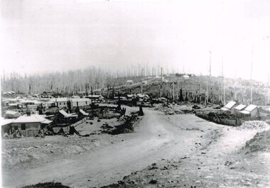
Photograph, Knox Collection, Beech Forest township, c.1903, c.1903
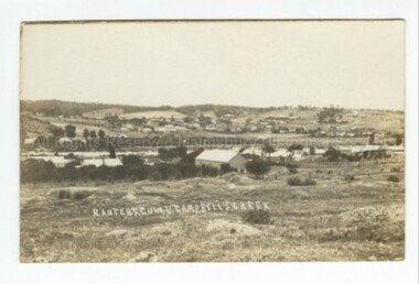
J.W. Gardner erected premises in Beech Forest which formed the core of a village. No further progress was made until access was facilitated though the development of a narrow gauge railway approved by the Victorian Parliament in 1898. Construction commenced in 1900. From this time Colac and Geelong business interests began investment in Beech Forest and established various retail and service establishments over the next few years. In 1902 three early settlers, Gardner, Charles Buchanan and John Cockerill, divided part of their land or bought land which was sold to businesses. On these subdivisions were created saleyards, general stores, a post office, bakery, blacksmithing, banks, a police station and lock-up, a public hall, churches, a state school, bootmaker, butcher, solicitor's office, hairdresser, billiard's saloon and newsagency.B/W. 188mm x 266mm. A general view of Beech Forest township in c.1903.beech forest; township; -
 Upper Yarra Museum
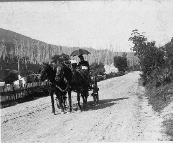
Negative Photographic Reproduction, Mrs Booth drives her buggy through Warburton township
Mrs Booth drives her buggy through Warburton township Negative Black white Scanned at 600 dpimrs booth driving buggy warburton township -
Clunes Museum
Map, DEPARTMENT OF LANDS AND SURVEY, TOWNSHIP OF CLUNES, PARISH OF CLUNES, COUNTY OF TALBOT, 1950
MAP OF CLUNES ON PAPER SHOWING HOTELS AND TOWNSHIP HIGHLIGHTS COMPLETE WITH LEGEND. OVERWRITTEN NOTATIONS IN RED AND BLUE INKPRICE 2stownship of clunes 1950, hotels of clunes -
 Malmsbury Historical Society
Postcard (Item), Postcard Ranters Gully Township C1910, Malmsbury c1910
Buildings - Township People - Township Ranter Gully -
 Stawell Historical Society Inc
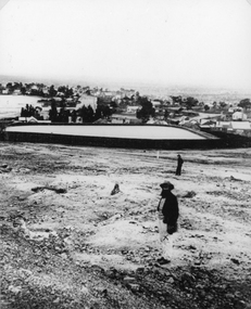
Photograph, Town Reservoir with Mr John D'alton & viewing of the township in the background
Reservoir on Big Hill (Early Scene)B/W Two males; closest has full beard in front of town reservior on Big Hill, background view of townshipstawell -
Whitehorse Historical Society Inc.
Document, Blackburn Township Estate, 1913
Auction of 23 villa and shop sites in the Blackburn Township estate by Coghill Haughton, Saturday 2nd August, opposite the railway station.Auction of 23 villa and shop sites in the Blackburn Township estate by Coghill Haughton, Saturday 2nd August, opposite the railway station. Auction of 23 villa and shop sites in the Blackburn Township estate by Coghill Haughton, Saturday 2nd August, opposite the railway station. blackburn township estate, coghill haughton -
 Pyrenees Shire Council
photograph, Untitled (Main thoroughfare through the township of Lexton ), c1880s
significant to the Pyrenees Shire and Lexton communityphotograph of Lexton streetscape "Throughfare through the township of Lexton in approx. 1880-1885 showing the Lexton Shop, Lexton Hotel and St. Mary's Anglican Church" -
 Victorian Aboriginal Corporation for Languages
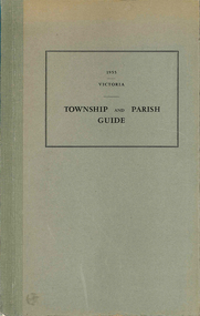
Book, Department of Crown Lands and Survey Victoria, Township and parish guide : Victoria, 1955
A alphabetical list of townships proclaimed under the Land Acts of Victoria. Shows the parish, land district and the municipality in which each is situated, and the particulars of Gazettal of Proclamation.victorian geographical names, victorian administration -
Linton and District Historical Society Inc
Conveyance document, Conveyance document, 1863 : sale of Allotment 15, Section 1, Township of Linton : Henry Franks to William Hugill
The land (with improvements) was sold for £650. Henry Franks had purchased the land for £16.15s at the Sale of Special Lands at Linton in 1861. The land, on the corner of Sussex and Clyde Streets, Linton, was later owned by David McFadzean, and after his death by several generations of the Barr/Greenbank families. It is understood that David McFadzean built the house there in 1873. (House still standing, generally referred to as "Barr's" - current address 64 Sussex Street, Linton.)A3 photocopy of an agreement ("indenture") made in 1863 between Henry Franks and William Hugill for the sale/purchase of Allotment 15, Section 1, Township of Linton. henry franks, william hugill, conveyance documents, land sales, land purchases, j. h. barr, david mcfadzean, allotment 15 section 1 township of linton, 64 sussex street linton -
Lakes Entrance Historical Society
Book, Green Os, Marlo The Township the Plains The Cape, 1984
History of Marlo Victoria from its settlement until 1983 includes sketch maps and photographs.township -
 Malmsbury Historical Society
Photograph (Item), Township Of Malmsbury (1879), Malmsbury
Buildings - Township -
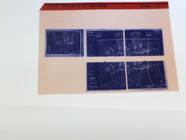
 Rutherglen Historical Society
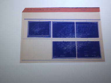
Microfiche of 5 Aperture Card sized microfilm, Victorian Land Tiltes Office, Township of Chiltern
Township layout of Chilterncard with a single microfilm insertplan, town, boundries, lots, roads -
 Rutherglen Historical Society
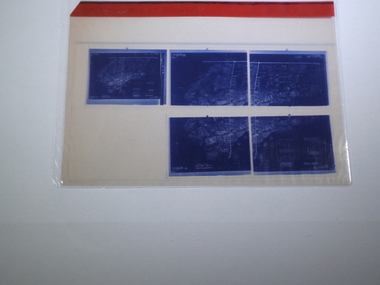
Microfiche of 5 Aperture Card sized microfilm, Victorian Land Tiltes Office, Township of Chiltern
Township layout of Chilterncard with a single microfilm insertplan, town, boundries, lots, roads -
 Rutherglen Historical Society
Microfiche of 5 Aperture Card sized microfilm, Victorian Land Tiltes Office, Township of Chiltern
Township layout of Chilterncard with a single microfilm insertplan, town, boundries, lots, roads -
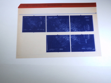 Rutherglen Historical Society
Microfiche of 5 Aperture Card sized microfilm, Victorian Land Tiltes Office, Township of Barnawartha
Township layout of Barnawarthacard with a single microfilm insertplan, town, boundries, lots, roads -
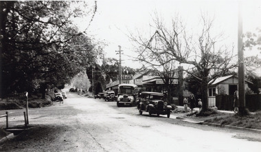 Mt Dandenong & District Historical Society Inc.
Photograph, Olinda Township c1950, c1950
Scene in Olinda township looking up towards range Road. Cars and busses parked along roadside and women and children on footpath. General Store and Gills Newsagency on LHS. c1950.olinda, gills newsagency -
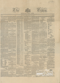 Eltham District Historical Society Inc
Newspaper clipping, Advertisement: New Township of Little Eltham, The Times, Late The Port Phillip Gazette, 12 April 1851, p1
Establishment of the township of Little ElthamLaminated front page and p2 (facsimile?)j.m. holloway, little eltham -
Stawell Historical Society Inc
Document - Realia, Certificate of Title Extract - Heatherlie Quarry Township
Heatherlie Quarry Township TitleCertificate of Title - A 3 Laminatedextract from Concongella Register book Vol 9806. Folio 608heatherlie quarry -
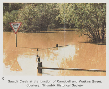 Eltham District Historical Society Inc
Work on paper (Sub-Item) - Photograph, Sawpit Creek at the junction of Campbell and Watkins Street, Diamond Creek Township, 8 April 1977
Colour photograph. Sawpit Creek at the junction of Campbell and Watkins Street, Diamond Creek Township. The Diamond Creek in flood at Diamond Creek township, 8 April 1977 Nillumbik Historical Society collectionflood, diamond creek, flooding, nillumbik historical society, give way, sawpit creek, campbell street, watkins street -
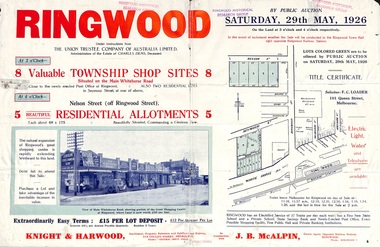 Ringwood and District Historical Society
Flyer, Township Shop Sites and Residential Allotments Sale By Public Auction, Ringwood, Victoria - 1926
Advertisement for eight township shop sites and five residential allotments for sale by Public Auction on the land in Ringwood on Saturday, 29th May, 1926, with location map, and summary of local features and services. Locality plan highlights sites for auction in Nelson Street, Seymour Street and Whitehorse Road. (Agents) Knight & Harwood, 315 Collins Street, Melbourne, Phones 10615, 10616 Central, in conjunction with J.B. McAlpin, Estate Agent, Opposite Railway Station, Ringwood, Phone Ringwood 7. -
Port Melbourne Historical & Preservation Society
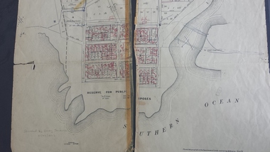
Plan, Department of Lands and Survey, The Township of Sandridge, 25 Nov 1860
Plan of the township of Sandridge lithographed at the department of Lands and Survey, Melbourne 5th November, 1860. Identical to 1859 version except for added rail line through Sandridge and onto Town Pierengineering - roads streets lanes and footpaths, municipal district of sandridge -
Tatura Irrigation & Wartime Camps Museum
Poster, Subdivision of Township Allotments
Poster depicting the land which was being sold by J S Darby on the 3 December 1890. Auctioneer was Martin Cussen and Co. Map shows location of land.Single sheet of paper, laminated. Advertising land subdivision for sale in the township of Rushworth. Being sold by Martin Cussen and Co, auctioneers for J S Darby. Shows map of land subdivision.rushworth, land subdivision, martin cussen and co, j s darby