Showing 186 items
matching township planning
-
 Port Melbourne Historical & Preservation Society
Plan - Township of Sandridge, 1855
... COPYRIGHT PUBLIC RECORDS OFFICE Plan of the Township... COPYRIGHT PUBLIC RECORDS OFFICE Plan of the Township of Sandrdge ...COPYRIGHT PUBLIC RECORDS OFFICE Plan of the Township of Sandrdge 1855 - copy from Public Record Office 1978local government - municipal district of sandridge, town planning, j jones -
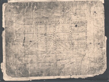 Bendigo Historical Society Inc.
Photograph - WES HARRY COLLECTION: TOWNSHIP OF SANDHURST, 1854
... Photograph of the Parish Plan of the Township of Sandhurst... Photograph of the Parish Plan of the Township of Sandhurst in 1854 ...Photograph of the Parish Plan of the Township of Sandhurst in 1854. It covers the area of the CBD from Mitchell (not named) to Bernal Streets and from the Bendigo Creek to Mollison St. ( other than Pall Mall and McRae streets, none of these parallel streets are named)place, bendigo, first survey, sandhurst, first survey, bendigo creek -
 Bendigo Historical Society Inc.
Map - JACK FLYNN COLLECTION: TOWNSHIP OF STANHOPE, December 1950
Map: Township of Stanhope, Parish of Girgarre, County of Rodney. Parish plan.By Authority J. J. Gourley, Government Printer, Melbourne. Drawn and Reproduced at the Dept, of Lands and Survey, Melbourne, Victoria.map, rodney, township, stanhope -
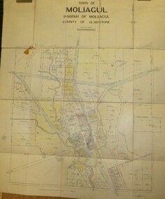 Bendigo Historical Society Inc.
Map - JACK FLYNN COLLECTION: MOLIAGUL, 7/02/1931
Map: Township of Moliagul, Parish of Moliagul, County of Gladstone. Parish plan.map, gladstone, township, moliagul -
 Bendigo Historical Society Inc.
Map - JACK FLYNN COLLECTION: GIRGARRE, 1957
Map: Township of Girgarre, Parish of Kyabram, County of Rodney. Parish plan.By Authority: W. M. Houston, Government Printer, Melbourne. Drawn and reproduced at the Department of Lands and Survey, Melbourne.map, rodney, township, girgarre -
 Bendigo Historical Society Inc.
Map - JACK FLYNN COLLECTION: GOORNONG, August 1953
Map: Township of Goornong, Parish of Goornong, County of Bendigo. Parish plan.By Authority W.M. Houston. Government Printer. Drawn and Reproduced at the Dept., of Lands and Survey, Melbourne, Victoria. August 1953map, bendigo, township, goornong -
 Bendigo Historical Society Inc.
Map - JACK FLYNN COLLECTION: HUNTLY, 12.03.1932
Map: Township of Huntly, Parish of Huntly , County of Bendigo. Parish plan. Western and South Riding Division on Main St. (Main Northern Highway) - written in ink below name of map.BY Authority H.J. Green. Photo-Lithographed at the Dept., of Lands and Survey, Melbourne. 12.3.32map, bendigo, township, huntly -
Bendigo Historical Society Inc.
Map - PLAN OF THE TOWNSHIP OF SANDHURST(PHOTOCOPY)
... PLAN OF THE TOWNSHIP OF SANDHURST(PHOTOCOPY)...Map: Photocopy of a plan of the Township of Sandhurst... streets Map: Photocopy of a plan of the Township of Sandhurst ...Map: Photocopy of a plan of the Township of Sandhurst. Dated 26 July 1854 ( number 141 in Map Cupboard 1)map, bendigo, city streets, township of sandhurst, early bendigo, city streets -
Bendigo Historical Society Inc.
Map - TOWNSHIP OF KANGAROO FLAT, 27/01/1932
Map: Township of Kangaroo flat, Parish of Sandhurst , County of Bendigo. Parish plan ( number 194 in Map Cupboard 1)map, bendigo, township, kangaroo flat -
Bendigo Historical Society Inc.
Map - RAYWOOD, 18/09/1930
Map: Township of Raywood, Parish of Neilborough,County of Bendigo. Parish plan (number 270 in map cupboard 1)map, bendigo, township, raywood -
Bendigo Historical Society Inc.
Map - GOORNONG, 1/10/1906
Map: Town of Goornong, Parish of Goornong, County of Bendigo. Parish plan (number 269 in map cupboard 1)map, bendigo, township, goornong -
Bendigo Historical Society Inc.
Map - STRATHFIELDSAYE, See above
Map: Township of Strathfieldsaye, Group of 4 plans, 2 hand drafted and 2 printed. Applied to canvas and stapled to the backing. The printed plans are dated January 1859 and 6th January 1871 (number 267 in map cupboard 1)map, bendigo, township, strathfieldsaye -
Bendigo Historical Society Inc.
Map - HARCOURT, 2/04/1917
Map: Town of Harcourt, County of Talbot. Parish plan (number 264 in map cupboard 1)map, talbot, township, harcourt -
Bendigo Historical Society Inc.
Map - TOWNSHIP OF HEATHCOTE (PART), 11/04/1935
Map: Township of Heathcote (part), Parish of Heathcote, County of Dalhousie. Parish plan (number 259 in map cupboard 1)map, dalhousie, township, heathcote, copunty of dalhousie -
Bendigo Historical Society Inc.
Map - TOWNSHIP OF HEATHCOTE SHEET 2, Circa 1935
Map: Township of Heathcote sheet 2. Parish plan (number 254 in map cupboard 1)map, dalhousie, township, heathcote -
Bendigo Historical Society Inc.
Map - TOWNSHIP OF HEAHCOTE SHEET 1, 29/07/1935
Map: Township of Heathcote sheet 1, parish of Heathcote, County of Dalhousie. Parish plan (number 253 in map cupboard 1)map, dalhousie, township, heathcote, conty of dalhousie -
Bendigo Historical Society Inc.
Map - FOSTERVILLE MAP, 19/08/1897
Map: Township of Fosterville, Parish of Ellesmere, County of Bendigo. Parish plan (number 277 in map cupboard 1)map, bendigo, township, fosterville, ellesmere -
Bendigo Historical Society Inc.
Map - YARRABERB, 17/12/1937
Map: Township of Yarraberb, Parish of Yarraberb, County of Bendigo. Parish plan (number 274 in map cupboard 1)map, bendigo, township, yarraberb -
Bendigo Historical Society Inc.
Map - NEWBRIDGE, August 17th 1875
Map: Township of Newbridge, Parish of Tarnagulla, County of Bendigo. Parish plan (number 272 in map cupboard 1)map, bendigo, township, newbridge -
Bendigo Historical Society Inc.
Map - AXEDALE, 12/07/1909
Map: Township of Axedale, Parish of Axedale, County of Bendigo. Parish plan (number 271 in map cupboard 1)map, bendigo, township, axedale -
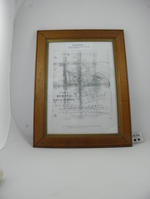 Echuca Historical Society
Map, Map of Township - Echuca
... Printed Survyor's plan for Echuca Township, date 5th March...-country Printed Survyor's plan for Echuca Township, date 5th March ...Map on white paper that has yellowed. Black print Handwriting is black but faded. In wooden frame behind glass. Printed Survyor's plan for Echuca Township, date 5th March 1855, from the Surveyor General Office. Melbourne March 5th 1855 Plan drawn by P Chauncey. Hand written- This plan is now a Port for the South Australian Steamer Trade - when Hopwood settled here/ it was only a wild bush - he is now throwing a bridge/ at his own cost across this river 200yards wide. signed by Henry Hopwood. Typed on backing paper: Plan of the township of ECHUCA dated March 1855, One month before the first land sales / Autographed by Henry Hopwood in Oct 1955. -
Tatura Irrigation & Wartime Camps Museum
Book, Warwick Finlay, The Doctor, The Captain, The Poet and Others, 2004
... over and early plan of Murchison Township... and Orion Horne over and early plan of Murchison Township The Doctor ...This book was printed to commemorate the 150th Anniversary of the survey, naming of the town and sale of land at Murchison.Black and white cover featuring the Goulburn River and portraits of Doctor McMillan, Captain John Murchison and Orion Horne over and early plan of Murchison Townshipmurchison -
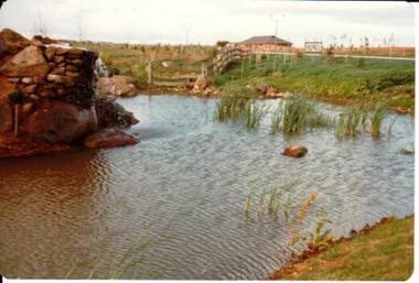
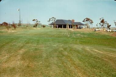
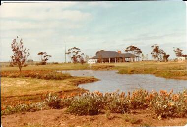
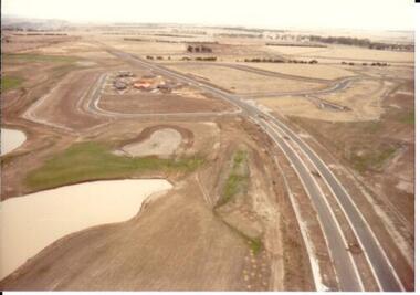 Hume City Civic Collection
Photograph, c 1978
On 4th August 1978 the construction of the Goonawarra Estate commenced. The estate was formerly known as the Goonawarra Farm and overlooked the Sunbury Township and the Jacksons Creek Valley. Plans for the development included a golf course, houses and community and recreational facilities. The golf course opened in 1980 and the housing construction continued throughout the last two decades of the twentieth century and into the twenty first century.A coloured aerial photograph of a display village area under construction. Two lakes are on the LHS of the photograph and Francis Boulevard is in the foreground and the middle distance.goonawarra golf club, goonawarra farm, goonawarra housing estate, housing developments, sharkey, robert b., kilkenny homes, australian ideas homes pty.ltd., glamor homes, craftsmen homes., villa bella homes, george evans collection -
 Hume City Civic Collection
Photograph, c 1978
On 4th August 1978 the construction of the Goonawarra Estate commenced. The estate was formerly known as the Goonawarra Farm and overlooked the Sunbury Township and the Jacksons Creek Valley. Plans for the development included a golf course, houses and community and recreational facilities. The golf course opened in 1980 and the housing construction continued throughout the last two decades of the twentieth century and into the twenty first century.A coloured photograph of the reflecting pool at the entrance of the Goonawarra Golf Club. The surrounding area has been landscaped and a display home is in the distance.goonawarra golf club, goonawarra farm, goonawarra housing estate, housing developments, sharkey, robert b., kilkenny homes, australian ideas homes pty.ltd., glamor homes, craftsmen homes., villa bella homes, george evans collection -
 Hume City Civic Collection
Photograph, c 1978
On 4th August 1978 the construction of the Goonawarra Estate commenced. The estate was formerly known as the Goonawarra Farm and overlooked the Sunbury Township and the Jacksons Creek Valley. Plans for the development included a golf course, houses and community and recreational facilities. The golf course opened in 1980 and the housing construction continued throughout the last two decades of the twentieth century and into the twenty first century.A coloured photograph of the clubhouse at the Goonawarra Golf Course taken from the 10th fairway. Parked cars are visible on the RHS of the photograpg and there is a row of gum trees behind the clubhouse.goonawarra golf club, goonawarra farm, goonawarra housing estate, housing developments, sharkey, robert b., kilkenny homes, australian ideas homes pty.ltd., glamor homes, craftsmen homes., villa bella homes, george evans collection -
 Hume City Civic Collection
Photograph, c 1978
On 4th August 1978 the construction of the Goonawarra Estate commenced. The estate was formerly known as the Goonawarra Farm and overlooked the Sunbury Township and the Jacksons Creek Valley. Plans for the development included a golf course, houses and community and recreational facilities. The golf course opened in 1980 and the housing construction continued throughout the last two decades of the twentieth century and into the twenty first century.A coloured photograph of the clubhouse at Goonawarra Golf Course as seen from the 10th green. A small white van is parked ouitside the building. There is a line of trees behind the clubhouse.goonawarra golf club, goonawarra farm, goonawarra housing estate, housing developments, sharkey, robert b., kilkenny homes, australian ideas homes pty.ltd., glamor homes, craftsmen homes., villa bella homes, george evans collection -
Clunes Museum
Plan - PLANS CLUNES CARAVAN PARK, NO. 1 - SHIRE OF TALBOT & CLUNES. IAN MANSLEY, SHIRE ENGINEER NO. 2 - LEO MCMAHON & ASSOCIATES PTY. LTD. LICENSED SURVEYORS & ENGINEERS, 31 LYONS ST. NTH. BALLARAT, 1976
... NO. 2 PLAN - SECTION 15 TOWNSHIP OF CLUNES, COUNTY OF TALBOT...Clunes Museum 36 Fraser Street Clunes goldfields PLANS ...NO. 1 PLAN - CLUNES CARAVAN PARK ENGINEER - IAN MANLEY NO. 2 PLAN - SECTION 15 TOWNSHIP OF CLUNES, COUNTY OF TALBOT, BY LEO MCMAHON AND ASSOCIATES, LICENSED SURVEYORS AND CIVIL ENGINEERSplans, caravan park, ian manley, plan section 15 -
Clunes Museum
Plan
... 1 PAGE - AN EARLY, UNDATED PLAN OF THE TOWNSHIP OF CLUNES... PAGE - AN EARLY, UNDATED PLAN OF THE TOWNSHIP OF CLUNES, COUNTY ...PLAN HAS AN ATTACHED HAND PRINTED CARD WITH INFORMATION REGARDING SITES. THIS HAS BEEN ADDED AT A MUCH LATER DATE.1 PAGE - AN EARLY, UNDATED PLAN OF THE TOWNSHIP OF CLUNES, COUNTY OF TALBOT, SHOWING REDUCED LEVELS AND CHAIN SURVEY OF ALL SECTIONSlocal history, plans -
Stawell Historical Society Inc
Map, Stawell Gold Mines, Plan View of Township Area Showing Known Old Workings. 2003, 13/06/2003
... Plan View of Township Area Showing Known Old Workings. 2003... workings on Map of Town North of Patrick Street Plan View ...Two AO Maps that Overlap Showing Old workings on Map of Town North of Patrick StreetScale 1 : 5000 -
Stawell Historical Society Inc
Map, Plan of Division Line between Ararat and Stawell Shires 1877, 1877
Grampians Halls Gap Black Range Stawell Shire Ararat Shire Crowlands TownshipVery Large Map Printed on Linen with Table of bearingsExamined by H.C. Malcolm 28.12.77 Traced By D.H. Meike 28.12.77survey