Showing 1049 items matching "trail"
-
 Eltham District Historical Society Inc
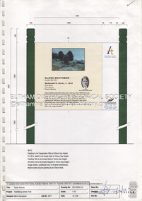
Document - Book, Execon Pty Ltd, Design Proofs, Heidelberg Artists Trail, Parks Victoria
Proof sheets for the design of signs to be placed along the Heidelberg Artists Trail for Manningham, Nillumbik, Yarra Ranges and Banyule CouncilsEach proof sheet initialled and dated by Andrew Mackenzie (24.12.1998)banyule city council, heidelberg artists' trail, manningham city council, nillumbik shire council, proof sheets, signs, yarra ranges shire council -
 Linton and District Historical Society Inc
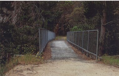
Photograph, Ballarat-Skipton Rail Trail, Linton, 2014
One of three colour photographs which have been printed on a single sheet of photographic paper. The photograph shows the Ballarat-Skipton Rail Trail where it goes over the Mortchup Road bridge (a former railway bridge) at Linton. The photograph was taken in 2014 by Gary Hunt.ballarat-skipton rail trail, mortchup road -
 Greensborough Historical Society
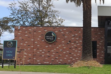
Photograph - Photograph - Digital Image, Marilyn Smith, Yarra Trail Medical 113 Mountainview Road Montmorency, 04/09/2021
Digital image of Yarra Trail Medical 113 Mountainview Road Montmorency. This medical centre was purpose built following a fire at this address.Part of a collection of miscellaneous historical images with a connection to the local area.Digital colour photograph. yarra trail medical, mountainview road briar hill, medical centres -
 Glenelg Shire Council Cultural Collection
Souvenir - Fridge Magnet - Casterton, Victoria, n.d
Unknown -
Box Hill Historical Society
Book, Marc Fiddian, Wandering Whitehorse Road, 2014
From Kew to Mansfield along Cotham Road, Whitehorse Road or Maroondah Highway108 pagesnon-fictionFrom Kew to Mansfield along Cotham Road, Whitehorse Road or Maroondah Highwaywhitehorse road, maroondah highway, fiddian> mark -
 Ringwood RSL Sub-Branch
Uniform - Uniform, Black Boots, shin height, lace up, Trail MP Boot, Circa 1980
General purpose black boots. -
 Phillip Island and District Historical Society Inc.
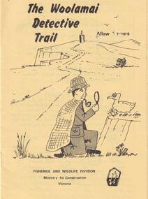
Booklet, Fisheries & Wildlife, The Woolamai Detective Trail, 11/1979
A Detective Booklet - 12 pages - put out by Fisheries and Wildlife Division to use when walking on the Cape Woolamai Trails. The dectictive is Shearwater Holmes and he's looking with your help for clues - like footprints or plants. All a bit of fun as well as education. 2 x booklets donated.Format by Alan J Reid, Gould League of Vic. No '79cape woolamai, the woolamai detective trail booklet, fisheries and wildlife, ministry for conservation, maurice schinkel -
 Greensborough Historical Society
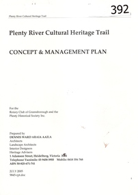
Report, Plenty River Cultural Heritage Trail : Concept & management plan, 2005_07
Prepared for the Rotary Club of Greensborough and Plenty Historical Society by Dennis Ward, this report outlines the heritage importance of the Plenty River Trail around Greensborough.This is an ongoing project by Dennis Ward. This report is an early version of the 2011 Squatters, speculators and settlers: Plenty River Cultural heritage trail. (Item 258) 66 page report, Illus, (some col.) , maps. In red 2-ring binder.Some handwritten notes in last pages.plenty river cultural heritage trail, dennis ward, rotary club of greensborough, plenty historical society, plenty river -
 Eltham District Historical Society Inc
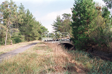
Slide - Photograph, Old Bridge, Warrandyte, Walter Withers, Heidelberg School Artists Trail, Warrandyte, c.2004
The Heidelberg School Artists' Trail extends from Heidelberg through Eltham and Warrandyte and to the Dandenongs. It features signs depicting paintings of artists in the location in which they were painted. 35mm colour positive transparency Mount - white 7 dots (Technodia Italy)heidelberg school artists trail, old bridge, public art, walter withers, warrandyte, warrandyte bridge -
 Eltham District Historical Society Inc
Photograph, Walk and Bicycle Trail; Eltham to Research, c. Oct 1987, 1987
Date based on other similar display panels visible in images of the Shire of Eltham display at the Eltham Community Festival, 7 November 1987.Colour photographdisplay panel, eltham festival, infrastructure, shire of eltham, bike paths, eltham, research (vic.), trail -
 Falls Creek Historical Society
Booklet - Falls Creek Snowsports School Information and Trail map 2002
Part of yearly marketing and information material promoting the Falls Creek Ski School. This publication includes detailed information about the Falls Creek Snowsport School Program for 2002. An introduction by the School Director, Benny Pregenzer states "Our motto is improving our guests skiing and boarding in a fun and safe environment. The most important facets of a good instructor are patience and empathy. These are qualities that our instructors display in every lesson and together with successful teaching methods, will ensure you experience fast improvement. Our instructors are carefully selected from Australia and all over the world to provide the highest quality service possible. Have a great holiday and see you on the slopes." The brochure bears the logo of Nursing Australia, proud sponsors of the Falls Creek Snowsport School.This item is important because it documents seasonal activities at Falls Creek Snowsport School in 2002.A glossy booklet featuring images and information about programs to be offered at Falls Creek in the 2002 winter season. The front cover features a group of downhill skiers while the back cover is illustrated with an image of a female snowboarder. Coloured images are included throughout the booklet. The centre page includes a map of trails at Falls Creek.On front cover Falls Creek and the resort Logo fallscreek.com.au Snowsport Schoolfalls creek marketing, falls creek ski academy, falls creek race club, falls creek snowsport school. -
 Eltham District Historical Society Inc
Book, D. Pendavingh, Yarra River Trail Plan 1989: Banksia Street to Warrandyte, 1989
Also contains a loose A3 mylar plan inserted - Depart of Planning and Urban Growth, Heidelberg; Main Yarra Trail; Warringal Parklands and Banyule Flats, Detail Plan and Locality Plan -
 Monbulk RSL Sub Branch
Book, Robyn Kienzle, The architect of Kokoda: Bert Kienzle - the man who made the Kokoda trail, 2011
Biography of Bert Kienzle who established a trail across the Owen Stanley ranges.Index, bibliography, ill (plates), p.327.non-fictionBiography of Bert Kienzle who established a trail across the Owen Stanley ranges.kienzle herbert thompson 1905-1988, kokoda trail (papua new guinea) -
 Whitehorse Historical Society Inc.
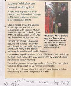
Article, Indigenous Art Trail, Sep 2023
A new walking trail has been created near Schwerkolt Cottage featuring indigenous art.non-fictionA new walking trail has been created near Schwerkolt Cottage featuring indigenous art.eastlink indigenous art trail, eastlink trail, mullum mullum creek, croydon hills men's shed -
 Eltham District Historical Society Inc
Photograph - Digital Photograph, Alan King, Manna Gums at the Gawa Wurundjeri Aboriginal Resource Trail, 28 December 2007
Manna Gum is a species of a small to a very tall tree that is endemic to south-eastern Australia. These particular trees are part of the Gawa Wurundjeri Resource Trail at Watsons Creek. Signs share information about how the Wurundjeri people lived near the creek and used the land to obtain bush foods, medicines, tools, shelter and clothes. The trail introduces visitors to the indigenous flora and fauna, including manna gums, Lomandra (used to weave baskets) and wombat burrows. Published: Nillumbik Now and Then / Marguerite Marshall 2008; photographs Alan King with Marguerite Marshall.; p3This collection of almost 130 photos about places and people within the Shire of Nillumbik, an urban and rural municipality in Melbourne's north, contributes to an understanding of the history of the Shire. Published in 2008 immediately prior to the Black Saturday bushfires of February 7, 2009, it documents sites that were impacted, and in some cases destroyed by the fires. It includes photographs taken especially for the publication, creating a unique time capsule representing the Shire in the early 21st century. It remains the most recent comprehenesive publication devoted to the Shire's history connecting local residents to the past. nillumbik now and then (marshall-king) collection, gawa wurundjeri aboriginal resource trail, manna gums, watsons creek -
 Eltham District Historical Society Inc
Negative - Photograph, Maroondah Aqueduct Trail near The Esplanade, Research, 1991
Looking northwest along the Maroondah Aqueduct Trail towards The Esplanade near Main Road, Research, 1991. Just after first bend from Main Road. To the left is present day (2022) Mickey's FitnessRoll of 35mm colour negative film, 9 strips Colour print 10 x 15 cmFuji HG 200 CA-1bridge, ingrams road, maroondah aqueduct, maroondah aqueduct trail, research (vic.), the esplanade -
 Eltham District Historical Society Inc
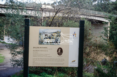
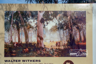
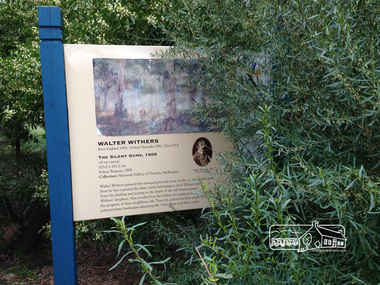
Photograph, Heidelberg Artists Trail sign, "The Silent Gums" Walter Withers 1909, Wingrove Park, Eltham, c.May 2001
The Heidelberg School Artists Trail was established in about 1999 with about 52 signs across four local governemnt areas including Nillumbik and Banyule. This one located in Wingrove Park Eltham pays tribute to Walter Withers and his painting "The Silent Guns"Roll of 35mm colour negative film, 7 stripsAgfa HDC 200 plus-2eltham, heidelberg artists' trail, wingrove park trail, walter withers, the silent gums -
 Greensborough Historical Society
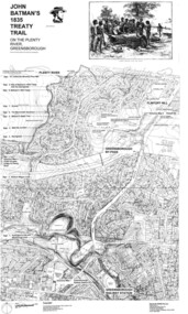
Map, Dennis Ward, John Batman's 1835 Treaty Trail on the Plenty River, 2010_
Map of the Plenty River through Greensborough and surrounding areas, annotated with historic places. Prepared by Dennis Ward, this map shows places of interest with historic markers for a proposed Heritage Trail along the Plenty. This was a joint project of Dennis Ward, Rotary Greensborough and Nillumbik Historical Society.This map shows many places of interest along the Plenty River. Large laminated map, including land subdivisions and street names.plenty river heritage trail -
 Eltham District Historical Society Inc
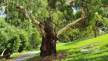
Photograph, Alison Delaney, Significant Eucalyptus tree, Diamond Creek Trail, Alistair Knox Park, Eltham, 21 Feb 2020
This tree is a significant tree located beside the Diamond Creek Trail in Alistair Knox Park. It was identified as the same tree in earlier photos from the 1980s. This images was taken just before the COVID-19 pandemic hit and the tree also has been tagged with grafitti on its trunk.alistair knox park, diamond creek trail, grafitti, significant tree -
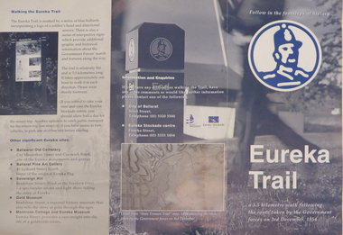 Federation University Historical Collection
Brochure, Eureka Trail, c2000
The brochure gives information on the Eureka Stockade which took place on 03 December 1854. The Eureka trail aimed at enhancing the Eureka experience and was developed in 1996. It was managed by the City of Ballarat with funding assistance form the State and Federal governments. Much of the work was undertaken under the New Work Opportunity Programme.Blue and white brochure highlighting relevant Eureka Stockade site. The brochure includes a map showing the route the Government forces took on their way to the Eureka Stockade as well as sites of interest to Eureka which are marked by blue bollards. The brochure was presented by the City of Ballarat and the Eureka Stockade centre.eureka, eureka stockade, diggers' trail, trooper's trail, eureka stockade centre, city of ballarat -
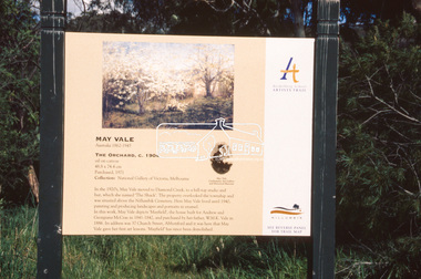 Eltham District Historical Society Inc
Slide - Photograph, The Orchard, May Vale (c.1904), Heidelberg School Artists Trail, Diamond Creek, c.Nov. 2001
The Heidelberg School Artists' Trail extends from Heidelberg through Eltham and Warrandyte and to the Dandenongs. It features signs depicting paintings of artists in the location in which they were painted. Part of a slide show presentation "A Trip Down the Diamond Creek" by Russell Yeoman to the Eltham District Historical Society meeting of 14 Nov. 200135mm colour positive transparency Mount - Black and Whiteart in public places, diamond creek, heidelberg school artists trail, public art, sign, may vale, the orchard -
 Eltham District Historical Society Inc
Slide - Photograph, Main Yarra Trail, Lower Plenty, c.Aug. 1990
Part of a presentation, "Roads and Byways of the Shire of Eltham", by Russell Yeoman to the 12 September 1990 Society meeting. Slides shown included copies of old photos and recent images ranging from the suburban streets of Eltham and Montmorency to the mountain roads of Kinglake. In the byways category are views of some iof the Shire's bicycle paths including then recently completed sections of the Main Yarra Trail at Lower Plenty.35mm colour positive transparency (1 of 37) Mount - Agfachrome Agfa CS System black 8 dotsinfrastructure, bonds road, lower plenty, main yarra trail, roads, significant trees -
 Eltham District Historical Society Inc
Slide - Photograph, Main Yarra Trail, Lower Plenty, c.Aug. 1990
Part of a presentation, "Roads and Byways of the Shire of Eltham", by Russell Yeoman to the 12 September 1990 Society meeting. Slides shown included copies of old photos and recent images ranging from the suburban streets of Eltham and Montmorency to the mountain roads of Kinglake. In the byways category are views of some iof the Shire's bicycle paths including then recently completed sections of the Main Yarra Trail at Lower Plenty.35mm colour positive transparency (1 of 37) Mount - Agfachrome Agfa CS System black 8 dotsinfrastructure, bonds road, lower plenty, main yarra trail, roads, yarra river -
 Eltham District Historical Society Inc
Slide - Photograph, Main Yarra Trail, Lower Plenty, c.Aug. 1990
Part of a presentation, "Roads and Byways of the Shire of Eltham", by Russell Yeoman to the 12 September 1990 Society meeting. Slides shown included copies of old photos and recent images ranging from the suburban streets of Eltham and Montmorency to the mountain roads of Kinglake. In the byways category are views of some iof the Shire's bicycle paths including then recently completed sections of the Main Yarra Trail at Lower Plenty.35mm colour positive transparency (1 of 37) Mount - Agfachrome Agfa CS System black 8 dotsinfrastructure, bonds road, lower plenty, roads -
 Robin Boyd Foundation
Document - Script, Robin Boyd, The Flying Dogtor. Episode 41 Golden Trail, 1963
The Flying Dogtor and the bush children found out where a bushranger had hidden treasure 100 years ago. Unfortunately, Crafty Carson Carpetbag and Old Man Redback found out just a little sooner, dug up the treasure first, and disappeared with it. But there must have been a hole in the chest, for the children found a gold coin on the ground, and then another and another. They set out to follow the trail with their faithful friend, The Flying Dogtor.The Flying Dogtor" series was broadcast on Australian Television Network (later becoming the Seven Network) between February and April 1964 (see item D254 for schedule).Typewritten, carbon copy, foolscap, 2 pagesthe flying dogtor, robin boyd, crawford productions, manuscript -
 Eltham District Historical Society Inc
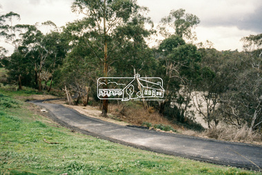
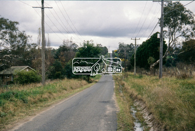
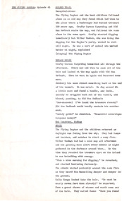
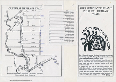
Folder, Cultural Heritage Trail Project, 1996
Correspondence, brochures, flyers, meeting agendas and minutes, evaluation sheet, list of sites and associated historical information and a Eltham Discovery talk produced by EDHS in 1992. on a project to develop a cultural heritage trail for the Shire of Nillumbik as part of a training program for future employmentvia LEAP a federally funded program through the Department of Employment Education, training and Youth Affairs. It was jointly sponsored by Montsalvat Trust and Nillumbik Shire Council. The project consisted of two parts: gathering the information and publishing it.37 pagesHG Booklet 51harry gilham collection, leap, trailblazers, heritage trail -
 Eltham District Historical Society Inc
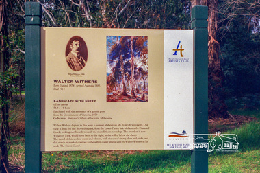
Photograph, Heidelberg Artists Trail sign, "Landscape with Sheep" Walter Withers, Wingrove Park, Eltham, c.May 2001
The Heidelberg School Artists Trail was established in about 1999 with about 52 signs across four local governemnt areas including Nillumbik and Banyule. This one acknowledges "Landscape with Sheep" by Walter Withers. The text on the board states: Walter Withers depicts in this work a number of sheep on Mr. Tom Orr’s property. Our view is from the rise above this park, from the Lower Plenty side of the nearby Diamond Creek, looking northwards towards the main Eltham township. The area that is now Wingrove Park, would have been to the right, in the valley below the sheep. The mood of this work is warm and vibrant, with the use of strong blues and pinks, and this stands in marked contrast to the softer, cooler greens used by Walter Withers in his work ‘The Silent Gums’.Roll of 35mm colour negative film, 7 stripsAgfa HDC 200 plus-2eltham, heidelberg artists' trail, wingrove park trail, landscape with sheep, walter withers -
 Eltham District Historical Society Inc
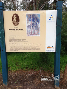
Photograph, Peter Pidgeon, Heidelberg Artists Trail signs are through this area including local artist Walter Withers, 2 Sep 2017
The Heidelberg School Artists Trail was established in about 1999 with about 52 signs across four local governemnt areas including Nillumbik and Banyule. This one located in Wingrove Park Eltham pays tribute to Walter Withers and his painting "The Silent Guns" Transcription of sign: Walter Withers – The Silent Gums, 1909 Walter Withers painted this tranquil pastoral scene in the vicinity this park. Here he has captured the dairy cattle belonging to local Eltham farmer, Mr. Tom Orr, feeding and resting in the shade of the tall Manna gums. Wither’s daughter, Nan recalled how her father, for inspiration, often visited the property of their neighbour, Mr. Tom Orr, and in his later years, Withers painted many landscapes depicting Mr Orr’s sheep and dairy cattle. Heritage Excursion by EDHS Members - An Eltham South Ramble, 2 Sep 2017Born Digitalactivities, eltham district historical society, eltham south, heritage excursion, local history centre, walter withers, heidelberg artists' trail, wingrove park trail, the silent gums -
 Eltham District Historical Society Inc
Photograph, Peter Pidgeon, Landscape with sheep by Walter Withers part of the Heidelberg Artist Trail, 2 Sep 2017
The Heidelberg School Artists Trail was established in about 1999 with about 52 signs across four local governemnt areas including Nillumbik and Banyule. This one acknowledges "Landscape with Sheep" by Walter Withers. The text on the board states: Walter Withers depicts in this work a number of sheep on Mr. Tom Orr’s property. Our view is from the rise above this park, from the Lower Plenty side of the nearby Diamond Creek, looking northwards towards the main Eltham township. The area that is now Wingrove Park, would have been to the right, in the valley below the sheep. The mood of this work is warm and vibrant, with the use of strong blues and pinks, and this stands in marked contrast to the softer, cooler greens used by Walter Withers in his work ‘The Silent Gums’. Heritage Excursion by EDHS members - An Eltham South Ramble, 2 Sep 2017Born Digitalactivities, eltham district historical society, eltham south, heritage excursion, local history centre, eltham, heidelberg artists' trail, walter withers, landscape with sheep, wingrove park trail