Showing 269 items matching "valley lake"
-
 Marysville & District Historical Society
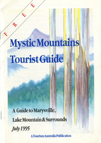
Ephemera (Item) - Tourist Guide, Graeme Haycraft, Mystic Mountains Tourist Guide July 1995, 07-1995
A tourist guide outlining services, accommodation, activities and places of interest to visit in and around Marysville, Lake Mountain and the local district.A tourist guide outlining services, accommodation, activities and places of interest to visit in and around Marysville, Lake Mountain and the local district.Acknowledgements/ Mystic Mountains Tourism Association, Marysville Office of the Dept. of Conser/ vation & Natural Resources, Mrs Elaine Postlethwaite, Ms Sue Henry & every/ advertiser without whose support this Guide would not have been possible.marysville, victoria, australia, tourist guide, mystic mountains, lake mountain, tourism australia, graeme haycraft, magic creek nursery, missing links miniature golf, phelps bakery, blackwood cottages, marysville hotel motel, tower motel, kerami house, marylands guest house, lomatia lodge, willowbank at taggerty, barree mud brick cottages, scenic motel, somerled mountain retreat, dalrymples guest cottages, nanda binya lodge, mathilde's of marysville country guest house, the birches resort, mystic mountains tourist information, marysville caravan park, the cumberland, igloo roadhouse, top shop pancake parlour, the silver birch restaurant, steavenson's restaurant, olde yarra track shoppe, danish coffee gardens, oscars take-away, country touch pottery studio & gallery, cumberland memorial scenic reserve, cathedral range state park, lady talbot forest drive, wishing well, taggerty river picnic area, taggerty river, phantom falls, keppels falls, the beeches walking track, mount sugarloaf, maryton park holiday cottages, snowviews, esa camping & conference centre, wirreanda festival, marysville post shop, hidden talent craft gallery, marysville automotive repairs, geoffrey pope & associates, beauty spot walk, tree fern gully walk, michaeldene track, marysville riding school, gerraty's ski centre, marysville holiday cottages, marysville triangle taxi service, fruit salad farm, lake mountain alpine resort, marysville ski hire, lake mountain ski school, cross country ski hire, lake mountain ski hire, marysville country club -
 Marysville & District Historical Society
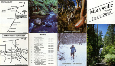
Ephemera (Item) - Tourist Guide, Marysville Tourist Association, Marysville Victoria Be our Guest, Unknown
A fold out tourist guide to Marysville and the surrounding district. This map was produced by the Marysville Tourist Association.A fold out tourist guide to Marysville and the surrounding district.marysville, victoria, australia, tourist guide, steavenson falls, mt cathedral lodge, camelot camel farm, danish coffee garden, marysville country club, crossways country inn, kufstein inn, marysville craft shop, gallery restaurant, the cumberland, tower motel, marysville hotel, scenic motel, fruit salad farm, marylyn guest house, marylands guest house, blackwood lodges, taggerty river, lake mountain -
 Marysville & District Historical Society
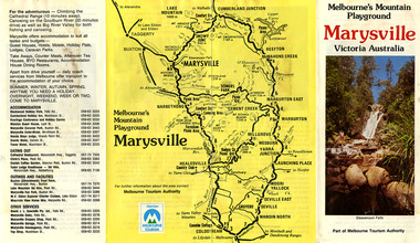
Ephemera (Item) - Tourist Guide, Melbourne's Mountain Playground Marysville Victoria Australia, Unknown
A fold out tourist guide to Marysville and the surrounding district.A fold out tourist guide to Marysville and the surrounding district.marysville, victoria, australia, steavenson falls, marysville golf club, cathedral range, blackwood holiday flats, cumberland holiday inn, kooringa conference and holiday centre, marylyn guest house, marysville caravan park, marysville hotel motel, nanda binya lodge, scenic motel, tower motel, cathedral restaurant, chris's place, danish coffee garden, tudor lodge roadhouse, buxton trout farm, silverstream trout farm, lake mountain ski hire, marysville fun park, mountain view horse hire, jl gould sawmills, marysville dairy, marysville drapery shop, marysville garage, marysville newsagency, top shop -
 Marysville & District Historical Society
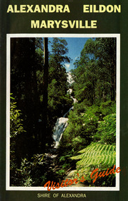
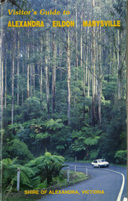
Ephemera (Item) - Visitor's Guide, Shire of Alexandra, ALEXANDRA EILDON MARYSVILLE Visitor's Guide, Unknown
A tourist guide for Alexandra, Eildon and Marysville produced by the Shire of Alexandra.A tourist guide for Alexandra, Eildon and Marysville produced by the Shire of Alexandra.alexandra, eildon, marysville, victoria, australia, tourist guide, steavenson falls, blackwood lodges, marysville hotel motel, the cumberland, gallery restaurant marysville, marysville gallery, cross country ski hire, marylyn guest house, marylands guest house, marysville crafts & gifts, hearts of oak antiques, geoffrey pope & associates, cedron house marysville, amber view holiday lodges marysville, marysville ski hire, lake mountain ski school, fruit salad farm, taggerty general store, arbor green galleries marysville, black spur roadhouse, black spur motel & caravan park, marysville caravan park, the hermitage narbethong, danish coffee garden, maryton park, buxton trout farm, lake mountain outdoor centre marysville, australian bush pioneer's farm, the camel farm and zoo buxton, marysville mountain view horse hire, marysville golf and bowls club, yarrolyn holiday park taggerty, riverland lodge taggerty, beauty spot walk, tree fern gully walk, michaeldene track, keppel track, woods lookout track -
 Marysville & District Historical Society
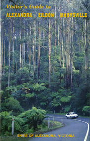
Ephemera (Item) - Visitor's Guide, Shire of Alexandra, Visitor's Guide to ALEXANDRA EILDON MARYSVILLE, Unknown
A tourist guide for Alexandra, Eildon and Marysville produced by the Shire of Alexandra.A tourist guide for Alexandra, Eildon and Marysville produced by the Shire of Alexandra.alexandra, eildon, marysville, victoria, australia, tourist guide, the cumberland, tudor lodge road house, the hermitage narbethong, blue views ski hire and holiday units narbethong, blackwood lodges marysville, marysville hotel motel, kufstein inn marysville, lake mountain, mary-lyn resort marysville, kooringa resort and conference centre marysville, mary's ville marysville, marysville crafts & gifts, geoffrey pope & associates, nanda binya lodge marysville, crossways country inn marysville, steavenson falls, scenic motel, marylands guest house, marysville holiday cottages, marysville newsagency & general store, el kanah, roseleigh holiday units, restaurant tirol, olde yarra track shoppe, marysville caravan park, dalrymples guest cottages, danish coffee garden, maryton park, tower motel, marysville golf and bowls club, taggerty general store, the camel farm and zoo buxton, buxton trout farm, yarrolyn holiday park, riverland lodge, marysville mountain view horse hire, beauty spot walk, tree fern gully walk, michaeldene track, keppel track, woods lookout track -
 Marysville & District Historical Society
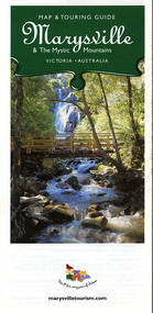
Map (Item) - Map and touring guide, Murrindindi Regional Tourism Association Inc, Marysville & The Mystic Mountains VICTORIA-AUSTRALIA, 08-2002
A fold out map and touring guide of Marysville and the surrounding district published in 2002 by Murrindindi Regional Tourism Association Inc.A fold out map and touring guide of Marysville and the surrounding district published in 2002 by Murrindindi Regional Tourism Association Inc.marysville, victoria, australia, map and touring guide, mystic mountains tourism, the beeches rainforest walk, lake mountain, cambarville, cathedral range state park, the cumberland, abbey green b&b cottages, anastasia fairytale cottage, ashlar cottage b&b, somerled mountain retreat, baree mudbrick cottages, blackwood cottages, camellia cottage, cathedral view b&b, cottage riverside, crossways country inn, dalrymples guest cottages, esa country ministries, hillcrest, keppels hotel motel, kerami house, lomatia lodge, lyell guest cottages, marylands country house, marysville caravan park, marysville holiday cottages, maryton park, melina cottage, moondai farm b&b, mountain lodge marysville, mount cathedral lodge, mystic mountains holiday cottages, nanda binya lodge, rendezvous on murchison, scenic b&b, the hermitage, tower motel, waratah house, willowbank at taggerty, woodlands of narbethong, keppels, lake mountain resort cafe, lanterns at willowbank, mantirri blueberry farm, marysville country bakery, the old woolshed cafe, clearstream olives, uncle fred & aunty val's old style lolly shop, acheron valley alpacas country store & gallery, bruno's art and sculpture garden, country touch, things of sand & stone, willowbank gallery, marysville auto & hardware, marysville newsagency & general store, marysville visitor information centre, narbethong visitor information centre, gallipoli park, keppels lookout, lady talbot drive, steavenson falls, steavenson river, taggerty river, acheron river, black spur trail riding centre, buxton trout farm, lake mountain resort ski hire, lake mountain ski school, marysville district country club, marysville ski centre, narbethong ski hire, rubicon horse riding, country touch tours, murrindindi regional tourism association inc -
 Marysville & District Historical Society
Map (Item) - Map and touring guide, Murrindindi Regional Tourism Association Inc, MARYSVILLE AND THE MYSTIC MOUNTAINS YARRA VALLEY-VICTORIA, Unknown
A fold out map and touring guide of Marysville and the surrounding district published by Murrindindi Regional Tourism Association Inc.A fold out map and touring guide of Marysville and the surrounding district published by Murrindindi Regional Tourism Association Inc.marysville, victoria, australia, map and touring guide, the cumberland, murrindindi regional tourism association inc, abbey green b&b, amberview lodge, anastasia fairytale cottage, ashlar cottage b&b, blackwood cottages, camellia log cabin, crossways country inn, dalrymples guest cottages, eagle mountain retreat, esa camping and conference centre, fruit salad farm, gilberts restaurant, keppels hotel motel, kerami house, kooringa resort and conference centre, lomatia lodge, lyelll guest cottages, marylands country house, marylyn holiday resort, marysville caravan park, marysville visitor information centre, alpacas at carmyle farm, australian adventure experience, bruno's art and sculpture garden, buxton trout farm, country touch tours, lake mountain, lake mountain ski hire, manical mechanicals, marysville district country club, marysville ski centre, rubicon valley horse riding, things of sand & stone, clearstream olives, the old woolshed cafe, fraga's cafe restaurant, lake mountain resort bistro, mantirri blueberry farm, gallipoli park, keppels lookout, cambarville, lady talbot drive, cathedral range state park, steavenson falls, steavenson river, taggerty river, acheron river, marysville auto and hardware, marysville newsagency & general store, narbethong visitor information centre, visit victoria -
 Marysville & District Historical Society
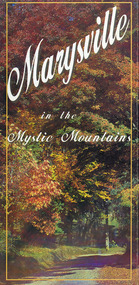
Map (Item) - Information brochure, Project Art & Photo, Marysville in the Mystic Mountains, Unknown
An information brochure on Marysville, the surrounding district and the natural attractions in the region published by Mystic Mountains Tourism.An information brochure on Marysville, the surrounding district and the natural attractions in the region published by Mystic Mountains Tourism.marysville, victoria, australia, information brochure, mystic mountains, mystic mountains tourism, cathedral range, lady talbot drive, cameron cascades, phantom falls, keppel falls, beech forest cascades, the beeches rainforest walk, the big tree, cumberland memorial scenic reserve, cambarville, cumberland falls, cora lynn falls, the big culvert, steavenson falls, lake mountain, marysville visitor information centre -
 Marysville & District Historical Society
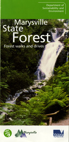
Ephemera (Item) - Information brochure, Department of Sustainability and Environment, Marysville State Forest, 2003
An information brochure on various forest walks and drives throughout the Marysville State Forest that was published by the Victorian Department of Sustainability and Environment in 2003.An information brochure on various forest walks and drives throughout the Marysville State Forest that was published by the Victorian Department of Sustainability and Environment in 2003.marysville, victoria, australia, information brochure, marysville state forest, lady talbot forest drive, taggerty river picnic area, the beeches, coupe loop, leadbeater's possum, beckter lookout, steavenson falls, marysville visitor information centre, department of sustainability & environmnet, lake mountain, cambarville, yarra ranges national park, cathedral range state park, murrindindi scenic reserve, gilberts gully loop, beauty spot nature trail, trestle track, michaeldene track, keppel lookout, marysville tour -
 Marysville & District Historical Society
Map (Item) - Tourist and business map, Narbethong Community and Tourism Group, the Gateway TOURIST AND BUSINESS MAP, 08-2009
A tourist and business map of Narbethong, Buxton, and Taggerty. This map was produced by the Narbethong Community and Tourism Group Inc in August 2009. It was produced to promote the natural attractions, adventure activities, and food trail from the Black Spur, through Narbethong, Buxton, and Taggerty.A tourist and business map of Narbethong, Buxton and Taggerty.This publication has been produced by the Narbethong Community and Tourism Group Inc./ (NCTG) The information provided in this publication has been supplied by the individual/ members. NCTG takes no responsibility for its accuracy./ August 2009narbethong, buxton, taggerty, victoria, australia, tourist and business map, the gateway tourist and business map, black spur motel & caravan park, woodlands rainforest retreat, chestnut glade, black spur inn, wombat cottage, abbey lake luxury b&b spa cottages, camp narbethong, marapana farm stay b&b, mantirri b&b, little dene garden cottages, nareen cabins, silverstream b&b cottages, buxton hotel motel, south cathedral farm luxury b&b cottages, cathedral view b&b retreat, kingbilli country estate, cathedral valley farm, pinjarra gardens, willowbank at taggerty, sarsens rest, yarrolyn caravan park, danico design counted cross stitch, things of sand & stone, buxton zoo nursery, safetrek 4wd services, mystic mountains ski hire & outdoors, pnl 4wdriving, buxton trout and salmon farm, buxton bait and tackle, black spur roadhouse, tudor lodge service station roadhouse & ski hire, buxton roadhouse, buxton p.o. general store, igloo roadhouse, henry v111 manor house, buxton hotel, butters cafe, wagtail wines, little river wines, narby eggs, marapana agistment park, carmyle farm, hazelwood hazelnuts, cathedral view naturall therapies, cre8ing growth, linda hailey, naby cabinets, gb timber, narbethong timber & trading, rb automotive repairs, buxton car care, martyn slade building design, taggerty vet clinic -
 Marysville & District Historical Society
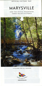
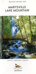
Map (Item) - Tourist map, Mystic Mountains Tourism, OFFICIAL VISITORS' MAP MARYSVILLE LAKE MOUNTAIN, Unknown
A visitors' map of Marysville and Lake Mountain produced by Mystic Mountains Tourism for Visit Victoria.A visitors' map of Marysville and Lake Mountain produced by Mystic Mountains Tourism for Visit Victoria.The Marysville and Lake Mountain Visitor Map and Touring Guide has been compiled and/ published by Mystic Mountains Tourism Inc. Copyright./ Production and artwork Graph Attack P/Lmarysville, lake mountain, victoria, australia, visitor's map, official visitors' map marysville lake mountain, buxton, narbethong, taggerty, visit victoria, mystic mountains tourism inc, graph attack p/l, mystic mountains, marysville triangle, marysville visitor information centre, marylands country house, black spur, steavenson falls, lady talbot drive, cambarville, cathedral ranges, wirreanda festival, lake mountain summit walk, summit walk loop, leadbeaters loop, day loop walk, buxton hotel, igloo roadhouse, karmann waters, silverstream b&b cottages, buxton trout and salmon farm, the niche wine bar, buxton post office & general store, choppers buxton roadhouse, woodlands rainforest bungalows, chestnut glade, black spur inn, wombat cottage, abbey lake luxury b&b spa cottages, mystic mountain ski hire & outdoors, pnl 4wdriving, blue views holiday units & ski hire, marapana agistment park & farm stay b&b, danico design, things of sand & stone, mantirri blueberry farm, allawah country cottages, amberview cottages, ashlar cottage b&b, black spur motel & caravan park, blackwood deluxe cottages, blackwood courtyard b&b, dalrymples guest cottages, delderfield, el kanah guest house, fruit salad farm, kerami guest house, keppels hotel, lake mountain-snow gum lodge, lomatia lodge, lyell guest cottages, magnolia house, keppel waters, lyrebird apartments, marysville caravan park, all view spa apartments, riverside cottages, maryton park b&b country cottages, melina cottage, mountain lodge, mystic mountains holiday cottages, nanda binya lodge, rendezvous luxury cottages, scenic b&b motel, the cumberland, south cathedral farm, tower motel, willowbank at taggerty, woodlands rainforest retreat, marysville & district country club inc, mystic mountains ski hire & outdoors, rubicon valley horse riding, marysville trout and salmon ponds, gallipoli park, keppels lookout, cambarville-yarra ranges national park, lake mountain-yarra ranges national park, lady talbot drive-yarra ranges national park, cathedral range state park, steavenson river, taggerty river, acheron river, lake mountain alpine resort, bruno's art and sculpture garden, manical mechanicals, uncle fred & aunty val's old style lolly shop, carmyle farm boutique, crossways historic country inn, fraga's, gilberts restaurant, heights licensed bistro, the old woolshed cafe, cathedral view natural therapies, crystal journey -
 Marysville & District Historical Society
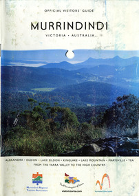
Booklet (Item) - Information booklet, Alexandra Newspapers, OFFICIAL VISITORS' GUIDE MURRINDINDI VICTORIA-AUSTRALIA, 03-2005
An information booklet on the Murrindindi region in Victoria. This information booklet was produced by Alexandra Newspapers in partnership with the Murrindindi Regional Tourism Association in March 2005.An information booklet on the Murrindindi region in Victoria.Produced and published by Alexandra Newspapers/ Pty Ltd in partnership with the Murrindindi Regional/ Tourism Association. murrindindi, victoria, australia, alexandra, eildon, kinglake, marysville, yea, yarra valley, high country, visit victoria, alexandra newspapers, murrindindi tourism association, rubicon valley horse riding, cathedral range state park, murrindindi scenic reserve, yarra ranges national park, cumberland memorial scenic reserve, the big culvert, cambarville, the big tree, steavenson falls, cora lynn falls, cumberland falls, lady talbot drive, phantom falls, keppel falls, the beeches, the cascades, wilhelmina falls, murrindindi cascades, lake mountain, cathedral lane vineyard, south cathedral farm, marysville holiday cottages, crystal journey, country touch, marysville ski centre, mountain lodge marysville, eco adventure tours, the mountain gallery, marysville country real estate, camellia log cabin, crossways historic country inn, marylands country house, ashlar cottage b&b, kerami guesthouse, melina cottages, willowbank at taggerty, mary lyn holiday resort, kooringa resort & conference centre, marysville caravan & holiday park, lyell guest cottages, eagle mountain retreat, keppels hotel motel, anastasia fairytale cottage, mystic mountain holiday cottages, esa camping & conference centre, buxton trout & salmon farm, woodlands rainforest bungalows, the old woolshed cafe, yarrolyn holiday park -
 Marysville & District Historical Society
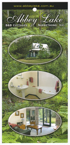
Flyer (Item) - Information flyer, Abbey Green B&B Cottages, Unknown
An information flyer on Abbey Lake B&B Cottages which were located in Narbethong.An information flyer on Abbey Lake B&B Cottages which were located in Narbethong.narbethong, victoria, australia, information brochure, abbey lake b&b cottages -
 Marysville & District Historical Society
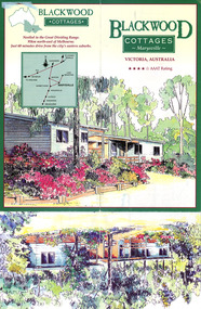
Ephemera (Item) - Information brochure, BLACKWOOD COTTAGES Marysville, Post 1996
An information brochure regarding Blackwood Cottages in Marysville.An information brochure regarding Blackwood Cottages in Marysville.marysville, victoria, australia, blackwood cottages, lake mountain, steavenson falls, accommodation, information brochure -
 Marysville & District Historical Society
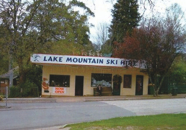
Photograph (Item) - Colour photograph, Unknown
A colour photograph of the Lake Mountain Ski Hire shop in Marysville in Victoria.A colour photograph of the Lake Mountain Ski Hire shop in Marysville in Victoria.marysville, victoria, lake mountain, lake mountain ski hire -
 Marysville & District Historical Society
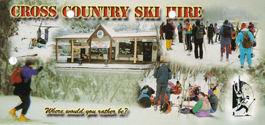
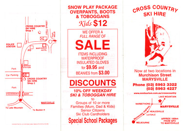
Ephemera (Item) - Advertising brochure, Cross Country Ski Hire, Unknown
An advertising brochure for Cross Country Ski Hire in Marysville in Victoria.An advertising brochure for Cross Country Ski Hire in Marysville in Victoria. This building, along with most of the town of Marysville, was destroyed in the 2009 Black Saturday bushfires.marysville, victoria, cross counry ski hire, lake mountain, 2009 black saturday bushfires -
 Marysville & District Historical Society
Ephemera (Item) - Advertising brochure, Cross Country Ski Hire, Unknown
An advertising brochure for Cross Country Ski Hire in Marysville in Victoria.An advertising brochure for Cross Country Ski Hire in Marysville in Victoria.marysville, victoria, cross country ski hire, lake mountain, ski hire -
 Marysville & District Historical Society
Ephemera (Item) - Advertising brochure, Cross Country Ski Hire, Unknown
An advertising brochure for Cross Country Ski Hire in Marysville in Victoria.An advertising brochure for Cross Country Ski Hire in Marysville in Victoria.marysville, victoria, cross country ski hire, ski hire, lake mountain -
 Marysville & District Historical Society
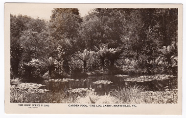
Postcard (Item) - Black and white postcard, Rose Stereograph Company, Garden Pool, "The Log Cabin", Marysville, Vic, 1913-1967
A black and white postcard of the ornamental lake that was in front of The Log Cabin in Marysville in Victoria.A black and white postcard of the ornamental lake that was in front of The Log Cabin in Marysville in Victoria. The Log Cabin was built by Thomas Henry Branchflower who had arrived from England late in 1921. It was built for Gwendoline Pitman after the death of her father Clarence Pitman and the disappearance of her sister Olive in July 1926. Gwendoline operated an artist and souvenir shop in the newly built Log Cabin in partnership with Peter Mackey who was a Melbourne optician and artist. This postcard was produced by the Rose Stereograph Company as a souvenir of Marysville.POST CARD The 'Rose" Series/ De Luxe A Real Photograph/ Produced in Australia Published by the Rose Stereograph Co./ Armadale, Victoria.the log cabin, thomas henry branchflower, gerald branchflower, marysville, mary chain, gwendoline pitman, clarence pitman, kooringa guesthouse, olive pitman, wilbur anderson, peter mackey, rose series postcard, rose stereograph co, p. 3502, postcard, souvenir -
 Marysville & District Historical Society
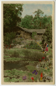
Photograph (Item) - Colour tinted photograph, Australian National Publicity Association, c1940s
A colour tinted photograph of The Log Cabin and its ornamental lake in Marysville in Victoria.A colour tinted photograph of The Log Cabin and its ornamental lake in Marysville in Victoria. The Log Cabin was built by Thomas Henry Branchflower who had arrived from England late in 1921. It was built for Gwendoline Pitman after the death of her father Clarence Pitman and the disappearance of her sister Olive in July 1926. Gwendoline operated an artist and souvenir shop in the newly built Log Cabin in partnership with Peter Mackey who was a Melbourne optician and artist. This photograph was produced by the Australian National Publicity Association.in Walkabout 1942/ This one tinted by Gwenda AUSTRALIAN NATIONAL PUBLICITY/ ASSOCIATION/ FLINDERS STREET RAILWAY STATION/ MELBOURNE, AUSTRALIA Not to be reproduced in Australia unless/ by special permission of the Australian/ National Publicity Association. The Log Cabin, Marysville, Victoria.thomas henry branchflower, gerald branchflower, marysville, mary chain, gwendoline pitman, clarence pitman, kooringa guesthouse, olive pitman, wilbur anderson, peter mackey, photograph, australian national publicity association, the log cabin -
 Marysville & District Historical Society
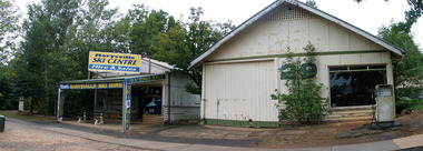
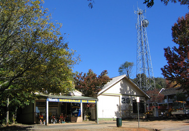
Photograph (Item) - Colour photograph, Unknown
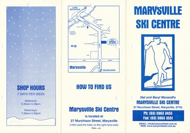
A colour photograph of the Marysville Ski Centre in Victoria.A colour photograph of the Marysville Ski Centre in Victoria. Marysville Ski Centre is a family-owned business, which has been operated by Nat and Beryl Morandi since 1981. The business started from very humble beginnings hiring toboggans at Lake Mountain initially from the back of a Bedford Van, and then upgraded to a rickety old shed with the addition of ski equipment for hire. In 1983, Marysville Ski Centre commenced business in its current position in Marysville. Then this building was destroyed, along with most of the buildings in Marysville, during the 2009 Black Saturday bushfires. Currently, the business operates from their new custom-designed ski hire which has been built to cater for the different needs of the hire.marysville, victoria, marysville ski centre, photograph, nat morandi, beryl morandi, 2009 black saturday bushfires -
 Marysville & District Historical Society
Ephemera (Item) - Advertising brochure, Marysville Ski Centre, Unknown
An advertising brochure for Marysville Ski Centre in Victoria.An advertising brochure for Marysville Ski Centre in Victoria. Marysville Ski Centre is a family-owned business, which has been operated by Nat and Beryl Morandi since 1981. The business started from very humble beginnings hiring toboggans at Lake Mountain initially from the back of a Bedford Van, and then upgraded to a rickety old shed with the addition of ski equipment for hire. In 1983, Marysville Ski Centre commenced business in its current position in Marysville. Then this building was destroyed, along with most of the buildings in Marysville, during the 2009 Black Saturday bushfires. Currently, the business operates from their new custom-designed ski hire which has been built to cater for the different needs of the hire.marysville, victoria, marysville ski centre, photograph, nat morandi, beryl morandi, 2009 black saturday bushfires -
 Marysville & District Historical Society
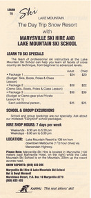
Ephemera (Item) - Advertising brochure, Learn to Ski Lake Mountain The Day Trip Snow Restort with Marysville Ski Hire and Lake Mountain Ski School, 1989
An advertising brochure for Marysville Ski Hire and Lake Mountain Ski School in Victoria.An advertising brochure for Marysville Ski Hire and Lake Mountain Ski School in Victoria. Marysville Ski Centre is a family-owned business, which has been operated by Nat and Beryl Morandi since 1981. The business started from very humble beginnings hiring toboggans at Lake Mountain initially from the back of a Bedford Van, and then upgraded to a rickety old shed with the addition of ski equipment for hire. In 1983, Marysville Ski Centre commenced business in its current position in Marysville. Then this building was destroyed, along with most of the buildings in Marysville, during the 2009 Black Saturday bushfires. Currently, the business operates from their new custom-designed ski hire which has been built to cater for the different needs of the hire.marysville, victoria, marysville ski centre, photograph, nat morandi, beryl morandi, 2009 black saturday bushfires, lake mountain ski school, lake mountain -
 Marysville & District Historical Society
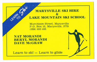
Ephemera (Item) - Business card, Marysville Ski Hire & Lake Mountain Ski School, Unknown
A business card advertising Marysville Ski Hire and Lake Mountain Ski School in Victoria.A business card advertising Marysville Ski Hire and Lake Mountain Ski School in Victoria. Marysville Ski Centre is a family-owned business, which has been operated by Nat and Beryl Morandi since 1981. The business started from very humble beginnings hiring toboggans at Lake Mountain initially from the back of a Bedford Van, and then upgraded to a rickety old shed with the addition of ski equipment for hire. In 1983, Marysville Ski Centre commenced business in its current position in Marysville. Then this building was destroyed, along with most of the buildings in Marysville, during the 2009 Black Saturday bushfires. Currently, the business operates from their new custom-designed ski hire which has been built to cater for the different needs of the hire.marysville, victoria, marysville ski centre, photograph, nat morandi, beryl morandi, 2009 black saturday bushfires, lake mountain ski school, lake mountain, dave mcgraw -
 Marysville & District Historical Society
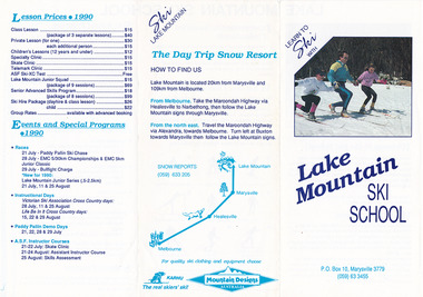
Ephemera (Item) - Advertising brochure, Learn To Ski With Lake Mountain Ski School, 1990
An advertising brochure for Lake Mountain Ski School in Victoria.An advertising brochure for Lake Mountain Ski School in Victoria. Marysville Ski Centre is a family-owned business, which has been operated by Nat and Beryl Morandi since 1981. The business started from very humble beginnings hiring toboggans at Lake Mountain initially from the back of a Bedford Van, and then upgraded to a rickety old shed with the addition of ski equipment for hire. In 1983, Marysville Ski Centre commenced business in its current position in Marysville. Then this building was destroyed, along with most of the buildings in Marysville, during the 2009 Black Saturday bushfires. Currently, the business operates from their new custom-designed ski hire which has been built to cater for the different needs of the hire.marysville, victoria, marysville ski centre, photograph, nat morandi, beryl morandi, 2009 black saturday bushfires, lake mountain ski school, lake mountain -
 Marysville & District Historical Society
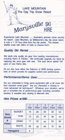
Ephemera (Item) - Advertising brochure, Lake Moutain The Day Trip Snow Resort Marysville Ski Hire, 1990
An advertising brochure for Lake Mountain Ski School and Marysville Ski Hire in Victoria.An advertising brochure for Lake Mountain Ski School and Marysville Ski Hire in Victoria. Marysville Ski Centre is a family-owned business, which has been operated by Nat and Beryl Morandi since 1981. The business started from very humble beginnings hiring toboggans at Lake Mountain initially from the back of a Bedford Van, and then upgraded to a rickety old shed with the addition of ski equipment for hire. In 1983, Marysville Ski Centre commenced business in its current position in Marysville. Then this building was destroyed, along with most of the buildings in Marysville, during the 2009 Black Saturday bushfires. Currently, the business operates from their new custom-designed ski hire which has been built to cater for the different needs of the hire.marysville, victoria, marysville ski centre, photograph, nat morandi, beryl morandi, 2009 black saturday bushfires, lake mountain ski school, lake mountain -
 Marysville & District Historical Society
Photograph (Item) - Colour photograph, Unknown
A colour photograph of the Marysville Ski Centre in Victoria.A colour photograph of the Marysville Ski Centre in Victoria. Marysville Ski Centre is a family-owned business, which has been operated by Nat and Beryl Morandi since 1981. The business started from very humble beginnings hiring toboggans at Lake Mountain initially from the back of a Bedford Van, and then upgraded to a rickety old shed with the addition of ski equipment for hire. In 1983, Marysville Ski Centre commenced business in its current position in Marysville. Then this building was destroyed, along with most of the buildings in Marysville, during the 2009 Black Saturday bushfires. Currently, the business operates from their new custom-designed ski hire which has been built to cater for the different needs of the hire.marysville, victoria, marysville ski centre, photograph, nat morandi, beryl morandi, 2009 black saturday bushfires