Showing 355 items
matching valley view road
-
 Greensborough Historical Society
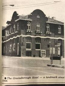
Newspaper Clipping - Digital Image, Diamond Valley News, Greensborough Hotel 1984, 1984_
Newspaper clipping showing the Greensborough Hotel in 1984. The hotel was built in 1926`.This view shows details of the exterior of the building.Digital copy of newspaper clippinggreensborough hotel -
 Greensborough Historical Society
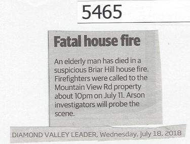
Newspaper Clipping, Diamond Valley Leader, Fatal house fire, 18/07/2018
An elderly man has died in a suspicious house fire at Mountain View Road, Briar Hill.News article 1 page, black text.briar hill fire, mountainview road briar hill -
 Greensborough Historical Society
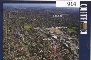
Photograph, Diamond Valley Leader, Greensborough: Aerial photograph, 21/05/2013
This advertisement for a property at 95 Alexandra Street Greensborough includes several aerial photographs of Greensborough with the Ring Road, Watermarc and Greensborough Plaza marked.An aerial view of Greensborough and surrounding areas in 2013.Colour advertisement including aerial photograph of Greensborough.alexandra street, greensborough plaza, watermarc -
 Greensborough Historical Society
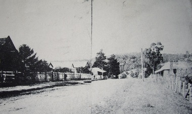
Photograph - Digital image, Main Street Greensborough, 1902
Early view of Main Street Greensborough showing the mainly residential nature of the buildings. Photographs from the collection of Peter Blackbourn, a descendant of the Chapman Stock family. Annotations to photos by Peter Blackbourn. Photo and article appeared in The Diamond Valley News 9/10/1984 page 29.Digital copy of black and white photograph.peter blackbourn, main street greensborough -
 Greensborough Historical Society
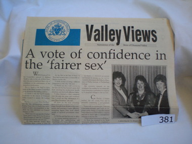
Magazine, Shire of Diamond Valley, Valley Views. October1991. October/November 1994, 1991_10
Valley Views was the newsletter of the Shire of Diamond Valley. The Shire of Diamond Valley was a Local Government Area located about 20 kilometres northeast of Melbourne. The shire covered an area of 74.38 square kilometres and existed from 1964 until 1994. 1994 edition commemorates the 30th anniversary of the Shire of Diamond Valley, in the final year before the Victorian state government amalgamated local government areas.Two editions of Valley Views. 1991 edition is 8 pages in broadsheet format (40 x 29cm), black and white illustrations. 1994 edition is 12 pages, colour illustrations, A4 (30 x 21 cm).shire of diamond valley, greensborough, valley views, diamond valley -
 Greensborough Historical Society
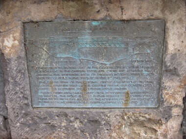
Photograph - Digital image, Dennis Ward, Bridge Plaque - Pioneer Park Greensborough, 27/03/2010
Plaque at Pioneer Reserve Greensborough: "Shire of Diamond Valley. The bluestones used in the construction of this viewing platform and in the carpark entry structure and retaining wall are from the northern arch of Greensborough's first Plenty River Bridge built in the 1860s adjacent to this site. The centre span of the original bridge was removed in 1865 when the western half of the existing bridge was constructed leaving the northern and southern stone arches. The southern arch was retained until floods in 1874 necessitated its removal. The picnic shelter in this reserve was constructed using stone from this abutment. The northern arch was removed in 1983 when widening of the existing bridge commenced."Digital copy of colour photograph.plenty river, pioneer reserve greensborough -
 Greensborough Historical Society
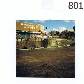
Photograph, Corner Para Road and Main Street Greensborough c1993, 1993_
The photograph shows road works on the corner of Para Road and Main Street Greensborough in 1993.The view also includes the Greensborough Hotel, the valley Buildings and the group of shops on the Para Rd corner named as Greensborough Valley Market. In the foreground it shows the Greensborough railway station car park as unsealed.A colour photograph of a street scene.Nilpara rd, main st, greensborough, road works, valley buildings, greensborough hotel, greensborough valley market -
 Greensborough Historical Society
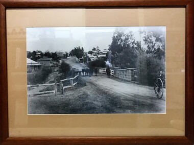
Photograph (Framed), Greensborough bridge, 1902-1925
View of bridge over Plenty River looking south up Main Street GreensboroughBlack and white photograph, mounted in wooden frame with glassValley Picture Framing, corner Church and Grimshaw Streetspioneer reserve greensborough, main street bridge -
 Halls Gap & Grampians Historical Society
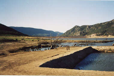
Photograph - Coloured, C 2007
This is a photo of the exposed swimming pool of Myrtlebank, which became exposed in Lake Bellfield during the drought years (2007 - ). The view is looking towards the dam wall and further road through the valley..Photo shows an exposed swimming pool (Myrtlebank Pool) in a very low reservoir (Lake Bellfield). There are dead branches in the water behind the pool and the dam wall and former road through the valley can be seen in the background.recreation, swimming pool -
 Halls Gap & Grampians Historical Society
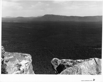
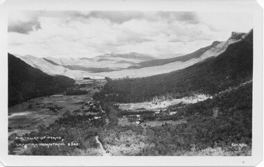
Photograph - B/W, C 1960s (?)
The photo is taken from Reed's Lookout.The photo shows the view across a valley from a (Reed's Lookout). The foreground is two large rock platforms. A reservoir (Moora Moora) and ranges can be seen in the background. Roads can be seen in the valley in the foreground.'Forests Commission, Victoria' inscribed on bottom, right of border. 'Publicity & Public relations Branch, When reproducing please Acknowledge Forests Commission, Victoria, Negative No. 322-23' stamped on back.scenery, lookouts -
 Halls Gap & Grampians Historical Society
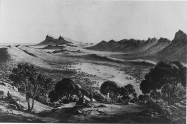
Photograph - B/W
This is a photo of a lithograph by Eugene von Guerard (1811-1901), "Source of the Wannon", circa 1866-1868. The peaks in the distance are Mr Abrupt and Signal Peak.This is a photo of a lithograph. It is a stylised view of a mountain range with sharp rocky peaks with a valley through the centre. A river meanders down the valley. There are eucalyptus trees in the foreground and two figures can be seen in the left foreground.Photo printers stamp in back is "H/GAP0007 NNNAA"painting, landscape -
 Halls Gap & Grampians Historical Society
Photograph - B/W
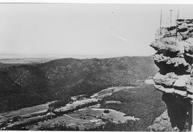
Viewing area is known as The Balconies overlooking Victoria Valley. Photo is typical of tourism photos taken by the Victorian Railways during this period. c1950 -60'sa group of people (17) standing on a rocky ledge overlooking a treed valley. a second rock ledge is above them creating the impression of a large mouth. Printed on back: Copyright Photograph. This photograph may be reproduced on condition that it is acknowledged a s 'VICTORIAN RAILWAYS PHOTOGRAPH'. P3465 written faintly in pencil. The Balconies Halls Gap written in blue penscenery, lookouts -
 Halls Gap & Grampians Historical Society
Photograph - B/W
Photo is of Moora Moora in the Victorian Valley. Typical of the time as a promotional image taken by Forests Commission Victoria.View over a large Valley with ranges in the distance. Roads through the valley are visible and a body of water in the middle right of the photograph. A rocky outcrop is in the left side foreground.Publicity & Public Relations Branch. When reproducing please acknowledge Forests Commission Victoria Negative no. 322-26scenery, grampians ranges -
 Halls Gap & Grampians Historical Society
Postcard - B/W
Photo on card was taken by Gilbert Rogers, a photographer and tour guide during the 1930s. This postcard is one of a series.Depicts as valley with mountains on both sides. Cleared land can be seen on either side of a road which runs through the valley. Buildings are also visible in middle area. View is running south-west.scenery, fyans valley -
 Halls Gap & Grampians Historical Society
Photograph - B/W, C 1950s (?)
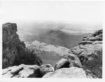
Photograph is of Fyans Valley taken from Bellfield Peak. The mountain range across the centre of the scene runs north to south. The large dwelling centre-front is Bellfield Hotel, which was destroyed by fire in the 1960s. The main road running through the middle of the valley is Grampians Road.A rocky outcrop, far right, with metal fence and posts. View of a valley with cleared land, roads and buildings in foreground. Further cleared land can be seen beyond a mountain range that is in the centre of the photograph.scenery, fyans valley -
 Halls Gap & Grampians Historical Society
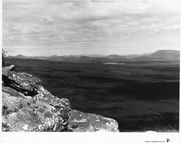
Photograph, C 1960s
The valley is known as Fyans Valley and the township of Halls Gap. Photo is typical of those taken by the Forestry Commission (Vic) during the 1960s.Photo shows two rocky outcrops in the foreground framing a valley in the distance below. A partial view of a mountain range flanks the valley. Plains of trees and open fields, and also a lake, can be seen beyond the mountain range. Within the valley in the middle of the photo buildings, roads and cleared land can be seen.scenery, fyans valley -
 Eltham District Historical Society Inc
Photograph, Spring Excursion, Hume and Hovell bus tour Stage 2, Seymour, Benalla; 26 Oct 1997, 26/10/1997
MONUMENT HUNTING THE HUME AND HOVELL WAY (Newsletter No. 117, November 1997, by Diana Bassett-Smith) Sunday October 26 1997 dawned bright and very warm. Some twenty-five members, complete with picnic baskets, met outside the Eltham Library awaiting the Cobb and Co. large coach which would be taking us on the second leg of our travels along the route of the early explorers Hume and Hovell. Stephen West was our very good driver for the day. He would be guided around the circuitous route by Russell Yeoman wh9 had made a detailed study, not only of the intended route, but of the story of these two explorers. During the trip Russell regaled us with poetry, quotations from the Journals and the History of the Shire of Seymour, "The New Crossing Place: by Martindale, 1982, (now Mitchell Shire due to the recent amalgamations). We headed towards the Hume Highway via Greensborough and Cooper Street and proceeded north to our first stop, noting on the way Monument Hill in the distance which is near Kilmore and, according to Russell, well worth the effort to visit as the view across the valley is magnificent. Past Sunday Creek Valley, Mt Piper and Mt Disappointment, all traversed and noted and named by them. We passed through Tallarook, then onto Seymour where we took photos of the monument telling us that Hume and Hovell had passed through on the 28th of October 1824. We also deviated down Hume and Hovell Road viewing deer and emu farming and the Bellbourie property now a sanctuary. Leaving Seymour behind we travelled up the Avenel Road to the Avenel monument, pyramidal in design of four reducing square blocks with a sharply pointed peak, erected in 1924 in memory of the 1824 exploration. The day was warming up and the countryside showing the dryness of the current drought. A parallel note had been made in their journal too of 1824 of the drought appearance of the country they were traversing. At Seven Creeks, Euroa we stopped for some minutes to check the monument placed 20th November 1924 to commemorate their passage on the 29th December 1824. More photos. Russell had pointed out the abrupt termination of the distant ranges which is noted in their journal. The next monument is beside the road at the entrance to Honey Suckle Creek Caravan Park, Violet Town. The squarish shaped monument some eight feet high is topped with a simple steel cross, and was to mark the date of 28th December 1824 and built for the 20th November 1924. By now it was 12.20 and nearly lunchtime as we drove along the Warranbayne Road to Roach's Road, monument hunting without success. Though there is a large, what appears to be an old timber sign which was hard to read, maybe this was the lost monument. In many of the paddocks hay had been cut and baled or was being cut, what a contrast to the rugged country they had passed through which was smoky from the fires of the natives burning off By 1.00 pm we were at Benalla and pulled up beside the park where abundant beds of roses filled the air with their scent and the smell of barbecued food twitched the nostrils whilst the cheerful sounds of other picnickers could be heard throughout the park. We left the bus and collected up our picnics, dispersed to the various tables and enjoyed the shade from the various European trees. 2.00 pm and we were on the road again driving along the Benalla, Mansfield, Yea road. The Swanpool monument states that they passed four miles south and returned three miles north. Then we stopped at the Barjarg monument which notes that they camped near this spot. It is again a pyramidal monument and this time topped with a steel arrow indicating their route of the 29th November 1824. Half an hour later we came to another monument, again with a steel arrow marker on top and the plaque dated the 2nd of 12th 1824. Erected on the 12th of 12th 1924. "They blazed the way that we might inherit the land." Another square based and needle topped monument appeared at Yarck near Yea and this plaque records the date of 3 December 1824. Near McGuigans Road Russell related that the expedition had lost a dog but it had found them next day, the dog was apparently torn by a kangaroo. A short while later Russell reminded us here of the problems they encountered in crossing the Goulburn River near Molesworth where banks were high, water deep and wide. "Good coat of grass but quite dry due to drought". At Yea we stopped for afternoon tea and raided the last of our picnics and looked at the monument to their journey of 1824, situated at a corner of the gardens near the bowling green. No photo – we were out of film. We returned home via Kinglake West and Whittlesea past the Yan Yean Reservoir, not full. 5.00 pm back at Eltham we emptied out of the bus and everyone, including Joan Cole, collected their things, Joan also had the major souvenir of the day, a large carp she had picked up from the river bank, her cat was in for a great feast. The day was made so interesting by the informed commentary which Russell provided. His background knowledge of the route and nature of the journey could only have come from many hours of reading and driving the area. Thank you to Russell and to everyone who made the day so informative and pleasurable. Diana Bassett-Smith. Record of the Society's history of activities - Spring 1997 excursionRoll of 35mm colour negative film, 6 stripsFuji 200shire of eltham historical society, activities, pretty hill, seymour, benalla, hume and hovell, monuments -
 Eltham District Historical Society Inc
Photograph, Spring Excursion, Hume and Hovell bus tour Stage 2, Seymour, Benalla; 26 Oct 1997, 26/10/1997
MONUMENT HUNTING THE HUME AND HOVELL WAY (Newsletter No. 117, November 1997, by Diana Bassett-Smith) Sunday October 26 1997 dawned bright and very warm. Some twenty-five members, complete with picnic baskets, met outside the Eltham Library awaiting the Cobb and Co. large coach which would be taking us on the second leg of our travels along the route of the early explorers Hume and Hovell. Stephen West was our very good driver for the day. He would be guided around the circuitous route by Russell Yeoman wh9 had made a detailed study, not only of the intended route, but of the story of these two explorers. During the trip Russell regaled us with poetry, quotations from the Journals and the History of the Shire of Seymour, "The New Crossing Place: by Martindale, 1982, (now Mitchell Shire due to the recent amalgamations). We headed towards the Hume Highway via Greensborough and Cooper Street and proceeded north to our first stop, noting on the way Monument Hill in the distance which is near Kilmore and, according to Russell, well worth the effort to visit as the view across the valley is magnificent. Past Sunday Creek Valley, Mt Piper and Mt Disappointment, all traversed and noted and named by them. We passed through Tallarook, then onto Seymour where we took photos of the monument telling us that Hume and Hovell had passed through on the 28th of October 1824. We also deviated down Hume and Hovell Road viewing deer and emu farming and the Bellbourie property now a sanctuary. Leaving Seymour behind we travelled up the Avenel Road to the Avenel monument, pyramidal in design of four reducing square blocks with a sharply pointed peak, erected in 1924 in memory of the 1824 exploration. The day was warming up and the countryside showing the dryness of the current drought. A parallel note had been made in their journal too of 1824 of the drought appearance of the country they were traversing. At Seven Creeks, Euroa we stopped for some minutes to check the monument placed 20th November 1924 to commemorate their passage on the 29th December 1824. More photos. Russell had pointed out the abrupt termination of the distant ranges which is noted in their journal. The next monument is beside the road at the entrance to Honey Suckle Creek Caravan Park, Violet Town. The squarish shaped monument some eight feet high is topped with a simple steel cross, and was to mark the date of 28th December 1824 and built for the 20th November 1924. By now it was 12.20 and nearly lunchtime as we drove along the Warranbayne Road to Roach's Road, monument hunting without success. Though there is a large, what appears to be an old timber sign which was hard to read, maybe this was the lost monument. In many of the paddocks hay had been cut and baled or was being cut, what a contrast to the rugged country they had passed through which was smoky from the fires of the natives burning off By 1.00 pm we were at Benalla and pulled up beside the park where abundant beds of roses filled the air with their scent and the smell of barbecued food twitched the nostrils whilst the cheerful sounds of other picnickers could be heard throughout the park. We left the bus and collected up our picnics, dispersed to the various tables and enjoyed the shade from the various European trees. 2.00 pm and we were on the road again driving along the Benalla, Mansfield, Yea road. The Swanpool monument states that they passed four miles south and returned three miles north. Then we stopped at the Barjarg monument which notes that they camped near this spot. It is again a pyramidal monument and this time topped with a steel arrow indicating their route of the 29th November 1824. Half an hour later we came to another monument, again with a steel arrow marker on top and the plaque dated the 2nd of 12th 1824. Erected on the 12th of 12th 1924. "They blazed the way that we might inherit the land." Another square based and needle topped monument appeared at Yarck near Yea and this plaque records the date of 3 December 1824. Near McGuigans Road Russell related that the expedition had lost a dog but it had found them next day, the dog was apparently torn by a kangaroo. A short while later Russell reminded us here of the problems they encountered in crossing the Goulburn River near Molesworth where banks were high, water deep and wide. "Good coat of grass but quite dry due to drought". At Yea we stopped for afternoon tea and raided the last of our picnics and looked at the monument to their journey of 1824, situated at a corner of the gardens near the bowling green. No photo – we were out of film. We returned home via Kinglake West and Whittlesea past the Yan Yean Reservoir, not full. 5.00 pm back at Eltham we emptied out of the bus and everyone, including Joan Cole, collected their things, Joan also had the major souvenir of the day, a large carp she had picked up from the river bank, her cat was in for a great feast. The day was made so interesting by the informed commentary which Russell provided. His background knowledge of the route and nature of the journey could only have come from many hours of reading and driving the area. Thank you to Russell and to everyone who made the day so informative and pleasurable. Diana Bassett-Smith. Record of the Society's history of activities - Spring 1997 excursionRoll of 35mm colour negative film, 6 stripsFuji 200shire of eltham historical society, activities, pretty hill, seymour, benalla, hume and hovell, monuments