Showing 178 items
matching viaduct
-
 Bendigo Historical Society Inc.
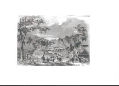
Photograph - RAILWAYS COLLECTION: PHOTO OF A SKETCH OF 'JACKSON CREEK VIADUCT OPENING
Railways collection -photo of a sketch of 'Jackson Creek Viaduct Opening (Courtesy ARHS Vic Division Inc.)'. The Jackson Creek Viaduct is a bridge about 24 miles from Melbourne and is 80 feet high being constructed of Footscray Bluestone piers and abutments and wrought iron girders. The girders were made in England and delivered to the colony by the time the the piers were ready to receive them. The laying of the foundation stone of this viaduct marked the opening of the line to Sunbury on 13 January 1859.photo, 'jackson creek viaduct -
 Orbost & District Historical Society
black and white postards, Rose Stereograph Company, 1940s -1950s
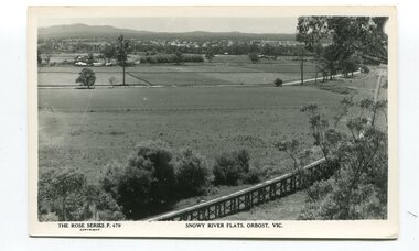
These postcards are part of the Rose series of photograph / postcards taken around Victoria. Rose was born in Clunes in 1861 and later worked in his father’s boot-making business in Prahran while studying photography. In 1880 he founded the Rose Stereograph Company and became famous for producing stereographs, or stereoviews, which gave the illusion of being in 3D when seen through a hand-held viewer, a big craze of the era. Rose produced stereoviews of the Western Front during the First World War. In all, he took about 9000 images in about 38 countries. As stereographs lost popularity in the 1920s, Rose switched to production of postcards and decorative cards, and he and the photographers who followed took thousands of scenes around Victoria as well as interstate that became iconic images of Australian life.These postcards are pictorial records of Orbost in the mid 20th century.Postcards such as these were a way of showing the scenic attractions of Orbost to potential tourists.Three black / white postcards of views over the Orbost flats and railway viaduct. 3183.1 is of a railway viaduct in the foreground and farming flats. 3183.2 is a view over the Orbost flats taken from Grandview Lookout. 3183.3 is a view from the Grandview Lookout showing the back of a woman looking across a rail fence. 3183.1 - bottom front - Rose Series P 478 SNOWY RIVER FLATS, ORBOST VIC 3183.2 - bottom front - Rose Series P 49 ORBOST, FROM GRANDVIEW HEIGHTS,VIC 3183.3 - bottom front - Rose Series P 14443 A VIEW FROM THE LOOKOUT, ORBOST, VICpostcards-orbost rose-series orbost-railway-viaduct grandview-lookout-orbost -
 Kew Historical Society Inc
Photograph - Outer Circle Railway Viaduct
The heritage listed Fairfield Bridge was originally constructed for the Outer Circle Railway to bridge the Yarra River between East Kew and Fairfield stations. In the 1930s it was converted for vehicular traffic. In the 2010s a new concrete bridge was erected beside it to increase vehicular capacity.Print copy, enlarged from original snapshot, of the former railway viaduct crossing the Yarra and linking Kew and Fairfield. The original photo predates the conversion of the viaduct into the Chandler Highway Bridge in the 1930s, when the Bridge was adapted to carry vehicular traffic. The date on the reverse indicates the date of donation rather than the date on which the photograph was taken. CHANDLER HIGHWAY BRIDGE OVER RIVER / (ORIGINALLY PART OF OUTER CURCLE RAILWAY) / OCTOBER 1977railway viaduct -- kew (vic.), fairfield bridge, fairfield railway viaduct, outer circle railway, sir john monash -
 Hume City Civic Collection
Photograph
A black and white photograph of the farm at Rupertswood in the foreground including the main house, school and farm together with the railway viaduct taken from the escarpment behind the property.rupertswood, farming, clarke, william (sir), farmbuildings, salesian order, salesian college, george evans collection -
 Ringwood and District Historical Society
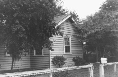
Photograph, Station hand's house near Wantirna Road bridge, Ringwood. 1986
Black and white photograph (2 images)Written on back of image F0098a: "This is house with external toilet. Station hand's house near viaduct, Wantirna Road. 1986." Written on back of image F0098b: " Wantirna Rd. Outside toilet. Station-hand's house. Near viaduct, 1986." -
 Kew Historical Society Inc
Photograph, J F C Farquhar, Railway Bridge Over the Yarra, 1891
At the beginning of the 1890s, the Kew businessman and Town Councillor, Henry Kellett, commissioned J.F.C. Farquhar to photograph scenes of Kew. These scenes included panoramas as well as pastoral scenes. The resulting set of twelve photographs was assembled in an album, Kew Where We Live, from which customers could select images for purchase.The preamble to the album describes that the photographs used the ‘argentic bromide’ process, now more commonly known as the gelatine silver process. This form of dry plate photography allowed for the negatives to be kept for weeks before processing, hence its value in landscape photography. The resulting images were considered to be finely grained and everlasting. Evidence of the success of Henry Kellett’s venture can be seen today, in that some of the photographs are held in national collections.It is believed that the Kew Historical Society’s copy of the Kellett album is unique and that the photographs in the book were the first copies taken from the original plates. It is the first and most important series of images produced about Kew. The individual images have proved essential in identifying buildings and places of heritage value in the district.Completed in November 1890, the railway viaduct (now the Chandler Highway Bridge) linked Kew and Fairfield. The viaduct is significant as the most substantial extant engineering remnant of the Outer Circle Railway Line. Opened in March 1891, the viaduct crossed the Yarra River in a single span, atop three supporting brick pillars. Following the closure of the railway line in 1927, and the construction of the Chandler Highway in 1930, the bridge was used for vehicular traffic. In 1891 when this panoramic photograph was taken, the grounds of what was then the Kew Lunatic Asylum extended down to the River and eastward beyond the viaduct. The landscape surrounding the Asylum was planted with traditional exotic trees such as Oaks, Pines and Cedars, and landmark trees from northern Australia such as the Hoop Pine. Remnant indigenous trees such as the River Red Gum, Yellow Box and Lightwood were scattered around the site, including beside the Yarra River.Railway Bridge Over the Yarrakew illustrated, kew where we live, photographic books, henry kellett, railway viaduct - - kew (vic) -
 Flagstaff Hill Maritime Museum and Village
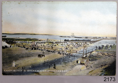
Postcard - Coastal Scene, Joseph Jordan, Sandy beach & breakwater Warrnambool, 1910
The coloured postcard depicts the Port of Warrnambool in the early 1900s. It shows the Breakwater, completed in 1890, the Viaduct, and the Merri River footbridge. There are many people on the sandy river banks, beach and bridge, and some are on the rocks of Middle Island. The printed postcard was made in England and is one of the Jordan Series produced by Joseph Jordan, a renowned photographer in Victoria's Western District.The postcard is locally significant as a record of the early footbridge over the Merri River, and the Viaduct before the space between the pylons was filled it. It shows the use of horses as a means of transportation. The photograph is also associated with Joseph Jordan, a renowned Victoria's Western District photographer.Postcard, coloured, showing the Port of Warrnambool. People are gathered on the sandy beach beside the river and near the river mouth. They are on and below the footbridge, along with several horses. Some are on the rocky Middle Island. There is a white ship in port. There is a jetty on the left, and buildings at the start of the breakwater. An inscription is printed at the bottom of the picture. The picture is one of the Jordan Series. It was printed in England in 1910."SANDY BEACH & BREAKWATER AT WARRNAMBOOL" "JORDAN SERIES" "PRINTED IN ENGLAND" "1910"warrnambool, shipwreck coast, flagstaff hill, flagstaff hill maritime museum, flagstaff hill maritime village, postcard, merri river, footbridge, warrnambool breakwater, breakwater, viaduct, middle island, port of warrnambool, jordan series, printed in england, 1910, joseph jordan, jordan photography -
 Yendon History Group
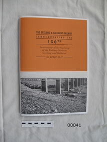
Book, railway, The Geelong & Ballarat Railway, Commemorating the 150th Anniversary of the Opening of the Railway between Geelong and Ballarat - 10 April 2012, 2012
Part of the contents of a souvenir gift bag given to those who rode on the re-enactment train for the 150th anniversary of the Geelong to Ballarat railway on 10 April 2012.A4 sized cardboard covered book, 50 pages. Cover orange with a white 5mm border. The bottom half of the front cover is an early photo of the Moorabool Viaduct.geelong ballarat railway, railway 150th anniversary, michael guiney -
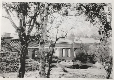
 Bendigo Historical Society Inc.
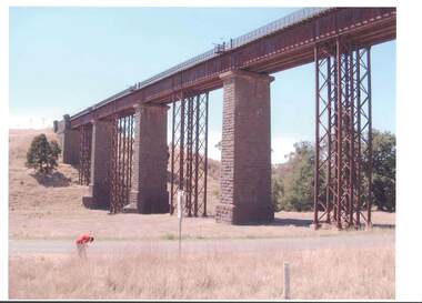
Photograph - RAILWAYS COLLECTION: COLOUR PHOTO OF THE TARADALE RAILWAY VIADUCT
Railways collection colour photo of a railway bridge -the Taradale Viaduct - on high stone pillars and steel girders spanning between two high areas. A man is seen in the foreground.photo, person -
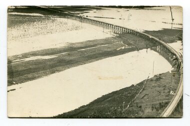 Orbost & District Historical Society
black and white photographs, second half 20th century
3154.1 is a postcard of the Orbost viaduct over the flooded Snowy River flats. 4153.2 is of a goods train on the viaduct. 3154.3 is of a loaded goods train with the driver at the window. Two men are standing on the plate and there are two workers below where there is some water and flood debris. 3154.4 is of amachine moving flood debris on the rail line. 3154.5 shows flood damage to the viaduct across the Snowy River flats. Two men are driving a dozer.This item is associated with the history of the Orbost-Bairnsdale railway line and therefore reflects the role that the rail line played in the social and economic history of Orbost.Five black / white photographs associated with the Orbost railway line during a flood.orbost-railway east-gippsland -railway orbost-floods -
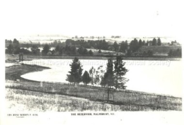 Malmsbury Historical Society
Postcard (Item), Postcard Of The Reservoir Malmsbury Rose Series P4156, Malmsbury c1923
Associated with - Rose Series P4156 Buildings - "Reservoir, Viaduct" -
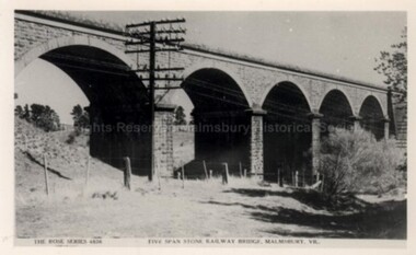 Malmsbury Historical Society
Postcard (Item), "Stone Railway Bridge Malmsbury, Rose 4836", Malmsbury c1930
Associated with - Rose Series P4836 Buildings - Malmsbury Viaduct -
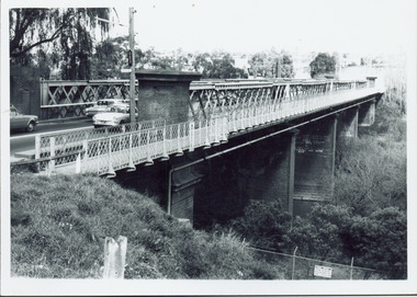 Kew Historical Society Inc
Photograph - Chandler Highway Bridge, 1977
The heritage listed Fairfield Bridge was originally constructed for the Outer Circle Railway to bridge the Yarra River between East Kew and Fairfield stations. In the 1930s it was converted for vehicular traffic. In the 2010s a new concrete bridge was erected beside it to increase vehicular capacity.Print copy of the Chandler Highway Bridge, [formerly the Fairfield Viaduct of the Outer Circle Railway] showing the original position of the walkway beside the bridge. The POV is from the Fairfield side looking towards Kew. CHANDLER HWY BRIDGE OVER YARRA / OCTOBER 1977 / ORIGINALLY BUILT FOR OUTER CIRCLE RWYchandler highway bridge, outer circle railway viaduct, bridges -- kew (vic.) -
 Federation University Historical Collection
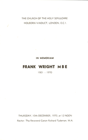
Booklet, In Memoriam Frank Wright MBE, 1970, 12/1970
Frank Wright was a renown resident of Smeaton, where he was born on 2 August 1901. He lived at Laura Villa, and attended Smeaton State School. His father William was a gold miner and his mother's name was Sarah. Their family won many singing and instrumental awards. Frank was tutored by Percy Code and was awarded a gold medal for the highest marks in the ALCM examinations in the British Colonies at the age of seventeen years. He became the Australian Open Cornet Champion by the age of eighteen. A year later, Frank conducted the City of Ballarat Band, and later the Ballarat Soldiers’ Memorial Band. He formed the Frank Wright Frisco Band and Frank Wright and his Coliseum Orchestra. These bands won many South Street awards, and Frank as conductor won many awards in the Australian Band Championship contest. In 1933 Frank Wright sailed to England to conduct the famous St Hilda’s Band and was later appointed Musical Director of the London County Council, where he organized many amazing concerts in parks, in and around the London district. He was made Professor of Brass and Military Band Scoring and conducted at the Guildhall of Music and Drama. Frank was often invited to adjudicate Brass Band Championships around Europe, in Australia, including South Street and in New Zealand. The Frank Wright Medal at the Royal South Street competition is awarded to an individual recognized as making an outstanding contribution to brass music in Australia. He died in England in 1970 at the age of 69.White soft covered Order of Service in Memoriam of Frank Wright, held at the Church of the Holy Sepulchre, Hoburn Viaduct, London on 10 December 1970. Gift of Frank Ritchie, Nephew of Frank Wright, 2014frank wright, funeral, church of the holy sepulchre, order of service -
 Malmsbury Historical Society
Photograph (Item), Frances Harkin & Partner Richard Neath October 2012 Of Malms, Malmsbury oct 2012
People - "Neath, Richard; Harkin, Frances" Associated with - "Made In Malmsbury Shop, Malmsbury Viaduct 150Th" -
 Bendigo Historical Society Inc.
Slide - DIGGERS & MINING. THE GOLD ERA, c1850
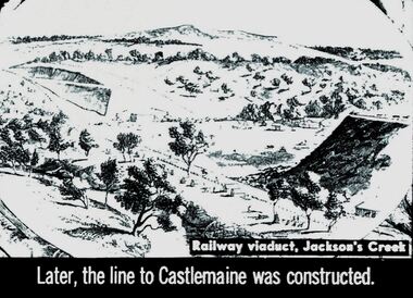
Diggers & mining. The gold era. Later, the line to Castlemaine was constructed. Slide shows rail line going between to valleys. Railway viaduct, Jackson's Creek. Markings 44 994.031 GOL:5. Used as a teaching aid.hanimounteducation, tertiary, goldfields -
 Sunbury Family History and Heritage Society Inc.
Photograph
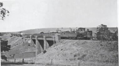
The two steam trains are hauling the carriages over the viaduct that spans Jacksons Creek, situated north of Sunbury. From 1859 until the introduction of diesel engines, steam trains were in regular use on the Sunbury - Bendigo line carrying passengers and goods to and from Melbourne.A black and white non-digital photograph of two large steam trains hauling passenger carriages over a three arched bridge. The surrounding countryside is made up of bare railways, railway viaduct, sunbury, jacksons creek -
 Malmsbury Historical Society
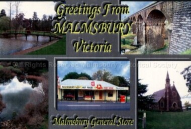
Postcard (Item), Postcard 5 Scenes In Malmsbury C2007, Malmsbury c2007
Associated with - "Malmsbury General Store, Townsend Graphics" Buildings - "Viaduct, St Johns Church General Store, Post Off." -
 Kew Historical Society Inc
Photograph, Chandler Highway Bridge, 1930s
The railway viaduct linking the Outer Circle railway from Kew to Fairfield was constructed in the 1890s. In the 1930s it was converted into a motorway bridge.Photocopy of a photograph of the bridge linking Kew and Fairfield. Dated to the 1930s following the construction off the Chanler Highway.outer circle railway, viaduct (kew fairfield), john monash, chandler highway bridge -
Malmsbury Historical Society
Photograph (Item), Mhs Members In Gardens Heritage Week 1991, Malmsbury apr 1991
People - "Castle; Slimmon; Morgan; Bates; Lindberg, Achison" Buildings - "Viaduct, Gardens" Associated with - "Mhs, Heritage Week, Macedon Ranges Leader" -
Malmsbury Historical Society
Photograph (Item), Mhs Members In Gardens Heritage Week 1991, Malmsbury apr 1991
People - "Castle; Slimmon; Morgan; Bates; Lindberg, Achison" Buildings - "Viaduct, Gardens" Associated with - "Mhs, Heritage Week, Macedon Ranges Leader" -
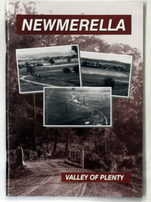 Orbost & District Historical Society
book, Newmerella Valley of Plenty, 2010
This is a 2nd edition of an earlier print, 1978. It has been revised and edited by John Phillips for the Orbost & District Historical Society in 2010. Harry Grosvenor was the headmaster at Newmerella School from 1962 to 1972. Harry was deeply involved in the 1978 publication by the Newmerella Progress Association called: Newmerella - Valley of Plenty. The book is a pictorial history of the early Newmerella district ( west of the Snowy River ).This is a local history book written by Harry Grosvenor a local author.A paperback book, titled Newmerella Valley of Plenty. The front cover is brown with white text and has three b/w photographs of the Snowy River flats as sen from the Newmerella hill. One is a photograph of the railway line with a steam train on the rail viaduct. newmerella-history -
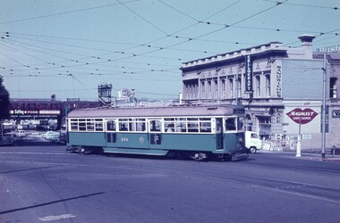 Melbourne Tram Museum
Slide, Keith Caldwell, Mar. 1962
Agfa Colour slide, cardboard, by Keith Caldwell dated March 1962 W6 948 turning from Flinders Lane into William St. In the background is the Railway Viaduct with a Tait Train, F A Nelken building (?), a sign for Cellokraft paper and Magikist Carpet Cleaners.In ink "March 1962"trams, tramways, w6 class, flinders lane, william st, tram 948 -
Malmsbury Historical Society
Photograph (Item), B/W Bob Castle & B. Slimmon Fishing, Malmsbury ca1991
People - "Castle, R; Slimmon, B; Manktelow, D" Buildings - Coliban River/Viaduct Associated with - M.H.S.Leader Newspaper (Macedon Ranges) H/Week -
Malmsbury Historical Society
Photograph (Item), B/W Bob Castle & B. Slimmon Fishing, Malmsbury ca1991
People - "Castle, R; Slimmon, B; Manktelow, D" Buildings - Coliban River/Viaduct Associated with - M.H.S.Leader Newspaper (Macedon Ranges) H/Week -
 Bendigo Historical Society Inc.
Document - RAILWAYS COLLECTION: BUILDING THE MELBOURNE TO BENDIGO RAILWAY BY P.MILLAR
Railways Collection -Photocopied article - Building The Melbourne - Bendigo Railway by P.Millar Pages 19-42. Copied on foolscap paper and stapled the article includes poor quality black and white photos of bridges and viaducts, and information about Construction Workers Riots over wages.P.Millar''railways, bendigo to melbourne -
 Ringwood and District Historical Society
Photograph, Maroondah Highway East, Ringwood- 1923. Start of Warrandyte Road railway bridge construction
Black and white photograph (3 copies- 2 large, 1 small sepia)Typed below large photograph: "Building Warrandyte Rd. subway 1923. Taken from Maroondah Highway." Written on rear of backing sheet: "Start of Pitt St. viaduct." -
 Sunbury Family History and Heritage Society Inc.
Photograph
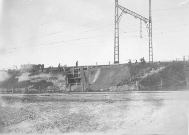
The photograph was taken when some work was being carried out on one of the arched railway bridges on the Sunbury line. The bridge spans the Jackson Creek and across the Rupertswood viaduct. The bridge over the Rupertswood Viaduct is one of the five significant bridges which span the railway line between Diggers Rest and Clarkfield.A black and white photograph of a bridge with scaffolding erected around the base of the arches.bridges, rupertswood viaduct, railway bridges -
 Melbourne Tram Museum
Slide - Set of 2, John Webster, 21/07/1959 12:00:00 AM
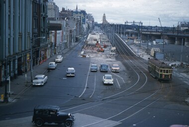
Set of two Colour slides, Kodak, white cardboard of trams of the construction of the Flinders St overpass over King St from the railway viaduct over Spencer St, looking east. Shows the temporary track on the south side of the bridge and the large car park under construction from the former cool stores on this site. Also shows the former track into Spencer St. Note the cross over at the base of the bridge. .1 - possibly 357 running a route 27 to Spencer St. Has the Great Southern Hotel on the left side. .2 - similar photo taken from the viaduct, further along - has the Bushels and Penfolds Wines signs in the background.Hand writing on rear in ink; .1 and .2 - "2-4-60 - Tracks - Flinders St Melbourne" Both slides have the speed and the f reading on the left hand side.trams, tramways, trackwork, flinders st, king st, track construction, bridges, w2 class, route 27, tram 357? -
 Robin Boyd Foundation
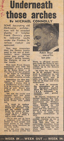
Newspaper - Clipping, Michael Connolly, Underneath those arches, 18-Dec-71
A report on hotelier Frank Dennis's plans to redevelop Flinders Street vaults under the Flinders St railway viaduct. The plans were drawn by Robin Boyd, and was one of his last projects.S and date handwrittenflinders street vaults, walsh st library