Showing 67 items
matching victoria consols
-
 Bendigo Historical Society Inc.
Document - LONG GULLY HISTORY GROUP COLLECTION: TALES OF VICTORIA HILL
... Victoria Quartz Co Victorian Consols Bendigo's Deepest Known Gold ...Two printed pages titled Tales of Victoria Hill. Mentioned is the gold yield on the New Chum Line of Reef, early gold discovery, Christopher Ballerstedt and his son Theodore, Theodore building Fortuna as well as a crusher or battery in its grounds. He believed he had exhausted the riches from his claims and sold the claim on the hill to George Lansell, deepest gold mine, interconnecting to neighbouring mines to obtain the required up and down drafts for ventilation, rising of the water levels resulting the closure of the Victorian Quartz Mine when a rope broke and the equipment that is still there. An accompanying photo of the Victoria Quartz Mine shows the buildings, chimney and poppet legs and a man standing in front of a building. There is also an accompanying floppy disc.bendigo, history, long gully history group, the long gully history group - tales of victoria hill, j n macarthy, christopher ballerstedt, theodore ballerstedt, fortuna, george lansell, lansell's 180, victoria quartz co, victorian consols, bendigo's deepest known gold bearing reef -
 Rutherglen Historical Society
Map, 1908
This is a map produced as part of a book entitled.. It is also stamped on the back in blue ink with an oval ring and the words North of England Institute. Newcastle. Mining & Meterolgical Faculty. Purchased on 23rd July 2017 by the Society after research by member Simon Killeen. Mining map of one of the first mines in Rutherglen area ( Chiltern West)Cream paper, black printing, rectangle with a drawingGeographical Survey of Victoria, Memoir, No6. Plate XX Plan of Underground Workings CHILTERN VALLEY CONSOLS MINE, RUTHERGLEN, PARISH OF CHILTERN WESTgold, rutherglen, mining, chiltern, underground mine map, geological survey, reef drives -
 Tarnagulla History Archive
Photograph - Photograph: Workers at Bendigo Consols Company N.L. on Poverty Reef, c.1898
Williams Family Collection. Photographer J.P. Lind also made an image at Shelbourne which is now in Museums Victoria collection: https://collections.museumsvictoria.com.au/items/767776 Monochrome photograph of workers at Bendigo Consols Company N.L. on Poverty Reef. An original photograph, mounted on card. Photographer's mark on reverse: "J.P. Lind Photographer Melbourne"tarnagulla, people, mining -
 Linton and District Historical Society Inc
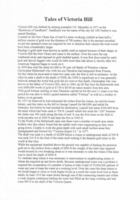
Share certificate, Berry, Anderson and Co Ballarat, Victoria, Jubilee Consols Gold Mining Company, 1899, 22 July 1899
Jubilee Consols Gold Mining Company - 50 shares for R. Gilpin of Ballarat.Blue grey paper with border on left hand side. Certifies that R. Gilpin of Ballarat is the owner of fifty shares in the Jubilee Consols Gold Mining Company at Browns, near Scarsdale. (R. Gilpin was also the manager of the company.)jubilee consols gold mining company, r. gilpin, browns [near scarsdale] -
 Linton and District Historical Society Inc
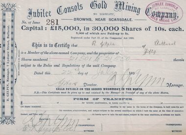
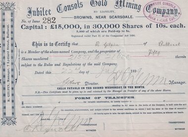
Share certificate, Berry, Anderson and Co Ballarat, Victoria, Jubilee Consols Gold Mining Company, 1899, 22 July 1899
Blue grey paper with border on left hand side.jubilee consols gold mining company, browns, gilpin -
 Linton and District Historical Society Inc
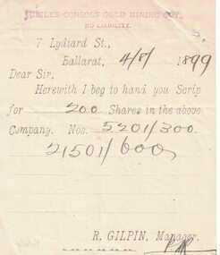
Letter, Berry, Anderson & Co Ballarat, Victoria, Jubilee Consols Gold Mining Company, 1899, 4.8.1899
Plain white paper with side perforations. Pre-printed note appears to have been detached from a book or a form. Date and share information filled in by hand. Letter is dated 4/8/1899, recipient's name not recorded. Letter accompanies scrip for 200 shares in the Jubilee Consols Gold Mining Coy., No Liability. Shares are numbered 5201-300 and 21501-600. Address of company printed at top: "7 Lydiard St, Ballarat". Name of manager printed at bottom: "R Gilpin, Manager".Text: " JUBILEE CONSOLS GOLD MINING COY., / NO LIABILITY / 7 Lydiard St., / Ballarat / 4/8/1899 / Dear Sir, / Herewith I beg to hand you Scrip / for 200 Shares in the above / Company. Nos. 5201/300 / 21501/600 / R. GILPIN, Manager.jubilee consols gold mining company, r. gilpin -
Bendigo Historical Society Inc.
Book - AUCTION SALES: MINING CATALOGUE AUCTION SALES
Blue, black & white Woolstar exercise book with black & white check pattern to the left and a world globe over the top. Name on the front: A Richardson. Written on the front: Mining Catalogue Auction Sales. Book contains Lot numbers and description for auction sales at various mines. Mines mentioned are: Central Blue Gold Mine 19/2/42, Big Blue 23/11/1938, South Blue, Hercules Consols 19/2/1942, South Virginia 19/2/42, New Prince of Wales 5/2/48, Golden Carshalton G M 19/12/1957, North Virginia 3/5/57, North Nell Gwynne 25/2/53, South Shaft Diamond Hill, New Don 21/10/48, Sheepshead Battery Site 21/10/48, Forbes Carshalton 9/7/47, South Virginia 9/7/47, East Clarence 31/8/49?, Deborah Surplus Equipment 31/8/49, Deborah No 2 Shaft, North Deborah 31/8/49, Hercules Main Shaft 19/6/1950, Stanfield Shaft 20/6/1950, United Crushing Coy Battery (Unity Carlisle) 20/6/1950, Toolleen Gold Mine 23/2/1950, Ironbark Gold Mine 6/10/49, Ironbark South 1/12/49, Hercules New Chum 1/12/49, Great Southern Gold Mine 10/4/47, New Chum Syncline 2/3/1950, Deborah Associated 19/4/195? And the Deborah Consolidated 19/4/1950. Further information of Bendigo Mines from The Gold Mining Registry Guide to Bendigo Mines by H Kirkwood, Eaglehawk. Published by W. Welch. Mines include Lazarus New Chum Reg'd & Lazarus New Chum No 1, Princess Alexandra, Ellenborough, Trio-Hauling Coy, South Catherine Reef G. M. C., Princess Alice, Central Catherine Co,Cravens New Chum Co N. L., Garibaldi Mining and Crushing Co, Williams United, Catherine Reef Claimholders G. M. N. L., New Chum & Victoria Reef, Johnsons (Garden Gully) Line, United Ulster, Garden Gully Rly Reserve, South Ulster, Ulster and Cosmopolitan Coys, Golden Gate and Lansell'sBig 180. Some information on the Moon Mines 24/6/67 South New Moon, New Moon, Nth New Moon and New Moon Consolidated.In the reverseof the book is some information on the Lazarus New Chum Mine, Lazarus No 1 and Lazarus Mines. Also mentioned are New Chum Rly and Victoria Quartz. In 1895 a large gold bearing reef in Lazarus at 3000 feet. Also Some extracts from E. C. Dunn's Report 13/8/92 on the Lazarus Mine Old Shaft and Lazarus Main Shaft at various depths. Book not located on 6.3.25. Typed notes from book are in folder.book, bendigo, mining auction sales, auction sales, mining catalogue auction sales, a richardson, central blue g m, big blue, south blue, hercules consols, south virginia, new prince of wales, golden carshalton g m, north virginia, north nell gwynne, south shaft diamond hill, new don, sheepshead battery site, forbes carshalton, south virginia, east clarence, deborah, deborah no 2 shaft, north deborah, hercules main shaft, stanfield shaft, united crushing coy battery (unity carlisle), toolleen gold mine - toolleen, ironbark gold mine, ironbark south, hercules new chum, great southern gold mine, new chum syncline, deborah associated, deborah consolidated, j h curnow, miss kirkwood, the gold mining registry guide to bendigo mines, h kirkwood, w welch, lazarus new chum no 1, mr g armstrong, princess alexandra, h hectmann, ellenborough, amos arblaster, trio hauling coy, catherine reef g m c, w burnside, st mungo reef, princess alice, central catherine co, big catherine, belmont, cravens new chum co n l, wm w barker, c edwards, ellesmere, garibaldi mining and crushing co, henry von der heyde, w martin, williams united, wm cook, john chynowth, catherine reef claimholders g m n l, churchill davidson, edgar l rosman, new chum and victoria reef, johnsons (garden gully) line, united ulster, james mccoll, james quick, garden gully reserve, south ulster, ulster and cosmopolitan coys, golden gate, geo lansell's big 180, signal of a mine, mr langridge, e clarke, j hattam, a llewelly, n murray, a richardson, new moon, nth new moon, new moon consolidated, lazarus new chum, lazarus no 1, new chum rly, victoria quartz, lazarus, e c dunn