Showing 192 items matching "victoria floods"
-
 Bendigo Historical Society Inc.
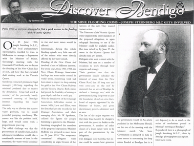
Newspaper - LONG GULLY HISTORY GROUP COLLECTION: THE MINE FLOODING CRISIS - VICTORIA QUARTZ
... Group - Bendigo Weekly James Lerk Victoria Quartz Joseph ...Copy of an article in the Bendigo Weekly titled The Mine Flooding Crisis - Joseph Sternberg MLC gets involved by James Lerk. Joseph Sternberg MLC travelled to Melbourne to arrange a deputation with the Minister of Mines to discuss the flooding of the New Chum line of reef. Pumping was mentioned but it would be expensive and would take time and the water would keep rising. They would also have to find a suitable pumping plant. The New Chum Drainage Association had kept the water under control. Delegates wanted the Government to subsidise the removal of the water.bendigo, history, long gully history group, the long gully history group - bendigo weekly, james lerk, victoria quartz, joseph sternberg, the honorable p mcbride, j h craig, new chum reef, new chum drainage association, new chum railway, mills lavis and elliot, mr w sparkman, melbourne herald, alan spicer -
 Bendigo Historical Society Inc.
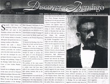
Newspaper - LONG GULLY HISTORY GROUP COLLECTION: THE MINE FLOODING CRISIS - NEW PUMPING TECHNOLOGY SUGGESTED
Copy of an article from the Bendigo Weekly 9/6/2000 titled The Mine Flooding Crisis - New Pumping Technology Suggested by James Lerk. Louis August Samuels was born in Germany. Samuels was involved in the mining industry in Australia and he had mining experience in West Africa. He had knowledge of the mines at the southern end of the field. He was president of the Mine Managers' Association. He believed the flooding was caused by the lack of baling and pumping operations. Earlier he had visited a coal mine in Bohemia to see a Riedler pump at work. It was a new design, very effective, simple in design and reliable. He watched it work. It was 500 metres underground and pushed the water to the surface in a single column. He suggested this type of pump could be adapted to use on the New Chum Reef. Even this suggestion was not the latest technical innovation, but it would be more efficient and less costly than baling. No one took him seriously and continued to remove water by the traditional means. Article is accompanied by a photo of Samuels.bendigo, history, long gully history group, the long gully history group - the mine flooding crisis - new pumping technology suggested, bendigo weekly 9/6/2000, james lerk, louis august samuels, origin of the bendigo saddle reefs and the cause of their golden wealth 1893, bendigo mine managers' association, victoria proprietary company, victoria quartz mine, new chum drainage association, riedler pump, riedler zwangschluss valve, technical school at aix-la-chapelle (achen) -
 Bendigo Historical Society Inc.
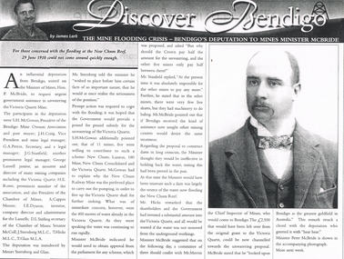
Newspaper - LONG GULLY HISTORY GROUP COLLECTION: THE MINE FLOODING CRISIS - BENDIGO'S DEPUTATION TO THE MINES MINISTER MCBRIDE
Copy of an article from the Bendigo Weekly 25/6/2000 titled The Mine Flooding Crisis - Bendigo's Deputation to Mines Minister McBride by James Lerk. The participants in the deputation were S H McGowan, J H Craig, G A Petrie, J G Stanfield, George Lansell Junior, H E Rowe, A Capper Moore, I E Dyason, S L Stirling, Senator McColl, J Sternberg, T Hicks and T Glass. It was hoped the Government would provide a pound for pound subsidy for the unwatering of the Victoria Quartz. Of the 11 mines, 5 were willing to contribute. The Minister thought dams would be ineffective. There is an accompanying photo of Minister Peter McBride.bendigo, history, long gully history group, the long gully history group - the mine flooding crisis - bendigo's deputation to mines minister mcbride, bendigo weekly 25/6/2000, james lerk, hon p mcbride, victoria quartz mine, s h mcgowan, bendigo mine owners association, j h craig, g a petrie, j g stanfield, george lansell junior, h e rowe, chamber of mines, a capper moore, i e dyason, d l stirling, senator mccoll, j sternberg, t hicks, t glass, new chum, lazarus, 180 mine, new chum consolidated, new chum railway mine, mr merrin, peter mcbride -
 Bendigo Historical Society Inc.
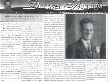
Newspaper - LONG GULLY HISTORY GROUP COLLECTION: THE MINE FLOODING CRISIS - FINALE OF THE VICTORIA QUARTZ
Copy of an article from the Bendigo Weekly titled Discover Bendigo The Mine Flooding Crisis - Finale of the Victoria Quartz by James Lerk. The lack of suitable machinery, insufficient knowledge of where the water was coming from, need for Government support, and the pegged price of gold, all contributed to the cessation of deep mining. The Victoria Quartz decided to allow tributers for work the upper levels. By 1913, the Company found it uneconomic to allow the tributers to continue working the upper levels and the poppet head and machinery were sold. During the Great Depression Ernest Smith, Davic Holden, Jack Harrison and David Patullo worked above the water line and did well enough to help their families from the worst effects of the Great Depression. Later Dave Patullo continued to work at the Victoria Quartz while the other three obtained employment in other mines. The article has a photo of David Patullo.bendigo, history, long gully history group, the long gully history group - the mine flooding crisis - finale of the victoria quartz, bendigo weekly, james lerk, victoria quartz mine, brough smyth, bendigo advertiser, victoria quartz company, great depression, ernest smith, david holden, jack harrison, david patullo, government battery eaglehawk -
 Bendigo Historical Society Inc.
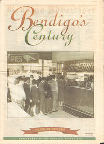
Newspaper - LONG GULLY HISTORY GROUP COLLECTION: BENDIGO'S CENTURY VOLUME SIX: 1950 - 1959
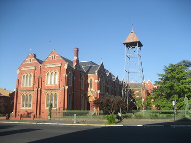
Newspaper supplement titled Bendigo's Century Volume six: 1950 - 1959. Front page has a photo of Gillies' famous corner, 1954. Each year has heading of Who's Who, Weather, Sport and Business. First year is 1950 titled Gillies: it's a Bendigo icon. 1951 is titled It's party time. 1952 - City mourns King George. 1953 - Mining ceases. 1954 - City thrilled at royal visit. 1955 - Push to save old Joss House. 1956 - Olympic fever grips Bendigo. 1957 - State Cabinet visits Bendigo. 1958 - Plan to keep historic mine. 1959 - Water storage woes solved. Back page has the Gillies Story.bendigo, history, long gully history group, the long gully history group - bendigo's century - volume six: 1950 - 1959, gillies' corner, bendigo advertiser, john lienhop mlc, north deborah mine, les gillies, alan gillies, norm gillies, black swan hotel, sir dallas brooks, cr a g weynton, bert mundy, cr poulston, the northern district school of nursing, lister house, the bendigo free library, rev dr c irving, shamrock hotel, sir albert dunstan, the most rev dr john mccarthy, jack davey, 1950 empire games, hercules gold mines, amy castles, ben templeton, cobb & co, cr norman oliver, reg parker, fred amer, les hammer, colonel george victor lansell, john quick, mr l w galvin, mr p j clarey mhr, hanro knitting mills, flooding, bendigo pottery, snow fall, the last lamp-lighter, the north deborah, aids & appliance shop, boardwalk, the late king george vi, the north deborah, beehive building, st paul's, st kilian's, upper reserve, bendigo trades hall, bendigo blackout, bendigo hospital, shamrock hotel, gerald smith, britannia hotel, mr a j harris, william morris (billy) hughes, andrew hampson, deborah anticline, north deborah, central deborah, diamond hill mine, north nell gynne mine, robert ross haverfield, sandhurst commercial courier, arthur moore lloyd, robert ross haverfield, angus mackay, jj casey, james henderson, david stuart, bendigo independent, colonel george lansell, bendigo base hospital, bendigo town hall, victorian electric traction association, the most rev b d stewart, st vincent's memorial college, commonwealth athletic club, south atlas racetrack, harp and shamrock hotel, mr and mrs f drake, cr f w clayton, cr r poulston, j h abbott & co, sir george lansell, clan macleod, bendigo gaol, queen alexandra fountain, belfast hotel, commonwealth bank, st vincent's college, lyric threatre, des duguid, brian cahill, lord's raceway, red white & blue extended gold mining company nl, central napoleon gold miningcompany nl, joss house, harry john, bendigo advertiser, mr leggatt, university of melbourne, anz bank, golden drive-in theatre, bank of australasia, john brown industries, bendigo football league, bendigo trotting club, faith leech, racv, bendigo sewereage authority, bendigo base hospital, bendigo benevolent asylum, henry bolte, jack davey, russell oakley, neville stilwell, channel seven, bendigo's olympic pool, annie caudle centre, strathfieldsaye aerodrome committee, southern airlines, cr d j osborn, cairn curran reservoir, state savings bank, commonwealth bank of australasia, belfast hotel, bennett's arcade, eppalock weir, bendigo cenotaph, sir edmund herring, cr a s craig, bendigo creche, bendigo high school, bendigo pottery, shamrock hotel, the venerable ronald richards, bishop riley, all saints cathedral, mr albert bush, bendigo arcade company ltd, woolworths, bull's head hotel, pike's corner, arcade hotel, upper coliban reservoir, cr tom flood, crystal egg co, sailor's guide, central deborah, central nell gwynne mine, bendigo benevolent home, ron masters, george daniel, eppalock dam, water commission, public works committee, bendigo central victoria telecasters ltd, channel nine, royal princess theatre, sir george lansell, volunteer defence corps, bendigo independent, countess erna cadorin, count ettore cadorin, ernst mueller, sutex pty ltd, dick turner, marco cavasassi -
 Victorian Interpretive Projects Inc.
Photograph - Colour, Clare Gervasoni, St Alipius Presbytery, Ballarat East, 07/01/2012
St Alipius Church was the first Catholic Church at Ballarat. It was initially a tent church in Humffray Street, but after flooding it was moved to Victoria Street were the current bluestone church was built. The presbytery is beside the church and houses the priests. A colour photograph in digital format showing red brick building with slate roof, behind a green iron fence. The building is St Alipius Presbytery, Victoria Street, Ballarat East. ballarat east, catholic, religion, church, st alipius', st alipius -
 Wangaratta RSL Sub Branch
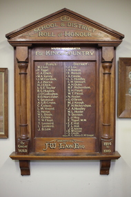
Honour Board, South Wangaratta School and District, circa 1919
The original South Wangaratta Primary School served the district for over 110 years and closed in December 1985 before moving to new premises. When the school closed in 1989 and with the demise of the South Wangaratta Hall due to flooding in the 1990's the Honour Board was wrapped in a blanket and stored in a shed for the best part of 10 years before being donated to the Wangaratta RSL for safekeeping and permanent display These listed men were either born, worked or enlisted at Wangaratta prior to serving their country in the First World War. Private William John LAW 1221 - 19 years - Born Murchison in Victoria. Occupation Carpenter Next of Kin - Father John Wilson LAW of Wangaratta Joined 2-3-1916 Enlisted at Wangaratta Unit 37th Battalion. Embarked Melbourne 3-6-1916 HMAT Persic A34 Discharged 21-9-1919. Private Joseph Henry LAW 986 - 21 years Born Euroa in Victoria Occupation Labourer Next of Kin - Mother Mrs Robert (Esther) LAW of Yatte Yattah - 18 NSW Joined 29-3-1915 Enlisted at Wangaratta Unit 24th Battalion. Embarked Melbourne 10-5-1915 HMAT Euripidies A14 Killed in Action 29-7-1916 France. Private Norman William FOSTER 7785 -18 1/2 years - Born Wangaratta Occupation Labourer Next of Kin - Sister Mrs William (Florence) McLean of Wangaratta Joined 15-7-1915 Enlisted at Melbourne Unit 54th Battalion Killed in Action 1-9-1918 France Private James Archibald McCORMICK 3195 - 19 years Born Wangaratta Occupation Engineer Next of Kin Father Samuel McCormick Enlisted Melbourne 27-7-1915 Embarked 26/11/1915 Unit 24th Battalion Killed in Action 5-8-1916 France Private Roland Caractacus HUGHES 3134(3131) - 20 years 5 months Born Wangaratta Occupation Blacksmith Next of Kin Father Roland W Hughes Joined 21-10-1915 Enlisted at Seymour 7th REIN 24th Battalion Embarked 26-11-1915 Wounded - GSW Leg and thigh RTA Discharged 11-10-1917 Private James Kelly O'CALLAGHAN 1250 - 22 years Born Mansfield Occupation Labourer Next of Kin Father John O'Callaghan Swanpool via Benalla Joined 6-3-1916 Enlisted at Wangaratta 37th/59th Battalions Embarked 3-6-1916 Wounded GSW Face and arm. RTA 30-1-1918 Discharged 2-7-1918 Private Samuel William DAVISON 6793 - 22 years 5 months Born Benalla Occupation Baker - Employer A Watson of Wangaratta Next of Kin Mother Mrs Ellen Tutty of South Wangaratta Enlisted Melbourne 3-1-1917 21/24th Battalions Embarked 11-5-1917 Wounded 9-8-1918 GSW Arm RTA 16-4-1920 (with wife) Discharged 26-7-1920 Private William Leslie HUNTER (Depot) 18 years 2 months Born Yan Yean Occupation Farmer/Labourer Next of Kin Father William James Hunter of Wangaratta Joined 18-2-1916 Enlisted Wangaratta 3-4-1916 Discharged at Seymour on 26-5-1916 Medically Unfit due to DiabetesThe honour board was made by John Wilson LAW and presented to the South Wangaratta School and District to honour the men who served in the First World War. John Wilson LAW was the father of two those who served.Timber Honour Board containing 48 names within two side columnsTop "School & District/Roll of Honour/South Wangaratta/For King & Country" Bottom 'The Great War/Presented by JW LAW. ESQ./1914 to 1919"south wangaratta, honour board, ww1 -
 Clunes Museum
Book, JEFFREY ATKINSON, THE CARDIGAN MINE DISASTER
ON THE 20TH AMRCH 1902 THE PEOPLE OF VICTORIA WERE SHCIKED TO READ IN THEIR NEWSPAPS THAT THERE HAD BEEN A MAJOR DISASTER AT A MINE JUST OUTSID BALLARAT IN WHICH A NUMBER OF MINERS WERE TRAPPED UNDERGROUND IN THE FLOODED WORKINGSON FRONT COVER: IMAGE OF MINING STRUCTURES AND MULLOCK HEAPS IN GREEN WAS HCOLOUR OVERVIEW OF GOLD MINING AND DEEP LEAD MINING IN PARTICULAR 58 PAGESnon-fictionON THE 20TH AMRCH 1902 THE PEOPLE OF VICTORIA WERE SHCIKED TO READ IN THEIR NEWSPAPS THAT THERE HAD BEEN A MAJOR DISASTER AT A MINE JUST OUTSID BALLARAT IN WHICH A NUMBER OF MINERS WERE TRAPPED UNDERGROUND IN THE FLOODED WORKINGScardigan mine disaster, mine collapse -
Tatura Irrigation & Wartime Camps Museum
Newspapers re/ local floods 1974, McPherson's Printing Group, Victoria, Tatura Guardian & Shepparton News, May 1974
Detailed history of 1974 floods in Shepparton and Mooroopna.Tatura Guardian 22 May 1974. Shepparton News 17th & 18th May 1974. Relating to record floods in the Goulburn River affecting Shepparton, Mooroopna, and Undera and to a lesser degree Tatura and Merrigum.record floods mooroopna & shepparton -
Tatura Irrigation & Wartime Camps Museum
Report, River Management, Drainage and Flood Plain Management, Report 1. 1982, 1980s
Typed reports about water management in Victoriairrigation -
 Hume City Civic Collection
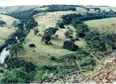
Photograph
Lochton Flour Mill was established in the 1850s and is only one of a few surviving mills in Victoria. It is situated on a horseshoe bend on the Deep Creek at Bulla.A coloured photograph of a horse shoe bend in a river and the open flood plain. The river is tree-lined. The ruins of a stone building are on the river bend. A damaged fence and prickly pears are in the foreground.lochton mill, deep creek, hunter, william morrison, george evans collection -
 University of Melbourne, Burnley Campus Archives
Photograph - Black and white print, Flood in Orchard, 1934
This photograph was sent to Burnley in an envelope printed, "On His Majesty's Service" Centenary Celebrations State of Victoria & City of Melbourne 1934-35 Department of Agriculture, Melbourne and handwritten on it "Flood in orchard 1/12/1934 Mr. Jessep." Note by T.H. Kneen 8 April 1992, "Alex Jessep (left) with Tom Trahair. Periodically Tom would take leave to go back to his home town Yackandandah to test a new theory to find the lost gold seam at the Little Waterloo mine."Black and white photograph. George Russ and Frank Ellery examining the ground by the flooded river. Uprooted trees behind them.This photograph was sent to Burnley in an envelope printed, "On His Majesty's Service" Centenary Celebrations State of Victoria & City of Melbourne 1934-35 Department of Agriculture, Melbourne and handwritten on it "Flood in orchard 1/12/1934 Mr. Jessep."george russ, frank ellery, centenary celebrations, orchard, tom trahair, 1934 flood, alex jessep, uprooted trees -
 National Wool Museum
Photograph, Yarra Falls: Yarra River in Flood
James Murgatroyd worked at Warrnambool Woollen Mills, Federal Mill, Tweedside, Collins Mills and set up looms for Alexander Spinning Mills Sydney, his son Fred Murgatroyd worked as a loom tuner at Yarra Falls, Tweedside and Collins mills in Victoria as well as in Sydney, and studied at Leeds University.Murgatroyd Photograph CollectionF Murgatroyd Yarra Falls: Yarra River in Flood KODAK PRINTtextile machinery textile mills textile mills, yarra falls mill, murgatroyd, mr fred murgatroyd, mr james, textile machinery, textile mills -
 National Wool Museum
Photograph, Yarra Falls: Yarra flood, early 1930's
James Murgatroyd worked at Warrnambool Woollen Mills, Federal Mill, Tweedside, Collins Mills and set up looms for Alexander Spinning Mills Sydney, his son Fred Murgatroyd worked as a loom tuner at Yarra Falls, Tweedside and Collins mills in Victoria as well as in Sydney, and studied at Leeds University.Murgatroyd Photograph CollectionF Murgatroyd Yarra Falls: Yarra flood, early 1930's KODAK PRINTtextile machinery textile mills weaving mills textile mills, yarra falls mill, murgatroyd, mr fred murgatroyd, mr james, textile machinery, textile mills, weaving mills -
Koorie Heritage Trust
Book, Robertson, Craig, Buckley's Hope : the real life story of Australia's Robinson Crusoe, 1981
Blurb: On Boxing Day 1803 a young English convict named William Buckley escaped from Victoria's abortive first settlement, at Sorrento. For the next thirty-two years Buckley survived in the wild, mainly because he was adopted and helped by the local tribes. In 1835 Buckley rejoined the civilization he had cast aside, emerging to meet Melbourne's founders. He became an important guide and interpreter in the crucial first years of the European conquest of the Port Phillip region. Then, as the Aborigines were engulfed by the flood of white men, Buckley found himself in no-man's land, mistrusted by his former black friends and by the white society who so misunderstood them. He was reviled, so harshly that his reputation has suffered to this day. This is William Buckley's story. It is a story based on fact, about a real Robinson Crusoe who was unique in Australia's history. And it is also a story of European intruders imposing their savage will on an alien, ancient continent. Rarely has Australian history come more alive than in the pages of this remarkable first novel. Buckley's life with the Aboriginal people of Port Phillip between 1803 and 1835; subsequent life in white community ; includes glossary of Aboriginal words (p. 271-280).288 p. : 3 maps ; 22 cm.Blurb: On Boxing Day 1803 a young English convict named William Buckley escaped from Victoria's abortive first settlement, at Sorrento. For the next thirty-two years Buckley survived in the wild, mainly because he was adopted and helped by the local tribes. In 1835 Buckley rejoined the civilization he had cast aside, emerging to meet Melbourne's founders. He became an important guide and interpreter in the crucial first years of the European conquest of the Port Phillip region. Then, as the Aborigines were engulfed by the flood of white men, Buckley found himself in no-man's land, mistrusted by his former black friends and by the white society who so misunderstood them. He was reviled, so harshly that his reputation has suffered to this day. This is William Buckley's story. It is a story based on fact, about a real Robinson Crusoe who was unique in Australia's history. And it is also a story of European intruders imposing their savage will on an alien, ancient continent. Rarely has Australian history come more alive than in the pages of this remarkable first novel. Buckley's life with the Aboriginal people of Port Phillip between 1803 and 1835; subsequent life in white community ; includes glossary of Aboriginal words (p. 271-280).buckley, william, 1780-1856 -- fiction. | novels in english. australian writers, 1945-. texts | convicts -- australia -- history -- fiction. | history - biographies - non-indigenous | settlement and contacts - penal colonies / convicts | settlement and contacts - colonisation - 1788-1850 | race relations - attitudes | language - vocabulary - word lists | kurnai / gunai people (s68) (vic sj55) | port phillip / western port area (vic sj55) -
 Ballarat Heritage Services
Photograph - Photograph - Colour, Clare Gervasoni, Nimon's Bridge, 1999, 04/10/1999
Nimons Bridge was built in 1890, as part of the then Ballarat-Linton railway. The bridge is 17 spans with tall timber piers of four driven piles each, with triple sets of diagonal cross-bracing and walers and a single row of longitudinal horizontal bracing between piers. The spans are of a uniform twenty feet (6.1 metres), originally supported by four 21-inch x 9-inch (535 mm x 230 mm) Kauri timber beams per span, following the standard V.R. design of the period. When the superstructure was rebuilt after the 1953 fire, the timber beams were replaced with two 24-inch (610mm) deep rolled-steel-joists on each span. These are marked 'Lancashire Steel Co., Scotland' and are believed to have been second-hand. The deck of transverse-timber planks is 103.6 metres in length. Overall the bridge has an impressive appearance with its exceptionally tall triple-cross-braced piers creating a 'three-tiered' effect, with the deck 19.2 metres above the Woady Yaloak River. The Ballarat-Skipton line closed in 1985. Nimons Bridge has been recently restored, as part of the Ballarat-Skipton Rail Trail. How is it significant? Nimons Bridge is significant for technical, historic and aesthetic reasons at a State level. Why is it significant? Nimons Bridge is technically significant as Victoria's fourth-tallest timber trestle bridge when built, and as the third-tallest surviving example. It is also the second-largest composite bridge combining traditional timber piers with RSJ spans and a timber deck and falls within a select group of fewer than ten timber railway bridges with horizontal longitudinal bracing between the piers and three sets of double cross-bracing on its tallest piers, creating a visually striking 'three tiered' effect that enhances its viaduct form. Nimons Bridge is historically significant as having served initially the mining community at Linton, then the Western District agricultural area and in later years a kaolin quarry at Pittong. Nimons Bridge is historically significant as a representative of the 'light' branch line methodology that stimulated the explosion of railway construction in Victoria during the 1880s, and provides an interesting contrast with the more solid and vastly more expensive railway viaducts built in similar terrain on Victorian main lines, at Moorabool and Taradale, in the late 1850s. Approached by a deep cutting and high embankment at either end, the bridge represents a very cost-effective late 19th century engineering solution to the characteristic physiography of western Victoria with flat basalt plains intersected by deep wide valleys occasionally subject to severe flooding. Nimons Bridge is aesthetically significant for its visually impressive viaduct form, crossing a deep and steep-sided valley that is part of a rich cultural landscape. Within close proximity of the bridge are mullock dumps, tailings, shaft sites and other relics of the deep-lead alluvial mining era. The bridge is the most visually spectacular timber-trestle rail bridge in Western Victoria and is among the most spectacular timber-trestle rail bridges surviving anywhere in Victoria. It is part of the Ballarat-Skipton Rail Trail. Classified by the National Trust :02/10/2000 (http://vhd.heritagecouncil.vic.gov.au/places/67986)Colour photograph of a log bridge known as Nimon's Bridge.ballarat-linton, nimons bridge, nimon's bridge, log bridge, viaduct, timber-trestle rail bridge -
 Ballarat Heritage Services
Photograph - Colour, Flood recovery, Carisbrook
... Colour photograph damaged during floods at Carsibrook... photograph damaged during floods at Carsibrook, Victoria. Flood ...Colour photograph damaged during floods at Carsibrook, Victoria. carisbrook flood, disaster recovery -
 Ballarat Heritage Services
Photograph - Photograph - Colour, Tippett's Paddock under Flood, Dean, 2016, 18/09/2016
... at Dean dean flood tippett potato farming agriculture Colour ...Tippetts are generational potato farmers at DeanColour photograph of Tippett's farm at Dean, Victoria. dean, flood, tippett, potato, farming, agriculture -
 Ballarat and District Irish Association
Photograph - Colour, Clare Gervasoni, St Patrick's Cathedral Hall, Ballarat, 2007, 20/11/2007
St Patrick's Cathedral Hall was erected in 1900 to the architectural plans of Clegg, Kell and Miller. The builder was Peter Bodger. The Cathedral Hall is a massive structure in the Gothic manner, with slender proportions and Gothic window detailing. The main hipped roof of the hall is intersected on both sides by four gables, and the front ridge is intersected by two further gables to form the street elevation. Internally the hall resembles many town halls except for the two tiers of Gothic windows and the manner in which the ceiling curves downward towards the walls. Pointed Gothic windows on the upper level intersect the curved ceiling in a simple groined junction. The plaster ceiling is coffered by intersecting beams, while a central skylight floods the hall with natural light. Other features of note are the ridging on the front gables, and the iron bell tower framed in steel angles and braced with criss-crossed rods, complete with a huge wheel and a great bell. St Patrick's Hall demonstrates a notable application of decorative schemes, particularly its highly decorated ceiling which has few parallels amongst other church halls in Victoria. The hall is in an important location as part of St Patrick's complex, as well as part of the group of churches which include St Andrew's Kirk and the former Baptist Church, opposite in Dawson Street. (http://stpatscathedral.weebly.com/cathedral-hall--presbytery.html, accessed 13 November 2013.A series of colour digital photographs showing a large red brick hall associated with St Patrick's Cathedral, Ballarat. The bell tower is situated to the right of the hall.ballarat irish, st patrick's cathedral hall, cathedral hall ballarat, bell, bell tower -
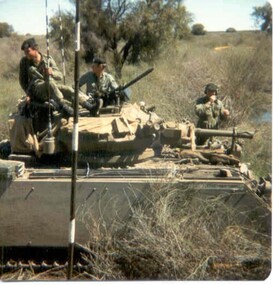 8th/13th Victorian Mounted Rifles Regimental Collection
Photograph - Born digital image
A region on the Lachlan River flood plain north of Booligal New South Wales with its lightly timbered grassland criss-crossed with numerous flowing channels and water filled billabongs provided a challenging training area for a unit equipped with M113 family of vehicles. A Squadron 8/13 VMR deployed there in September 1985 for its annual exercise. The MRV was from 3 Troop commanded by Corporal RAC (Bob) MacDonald of Wangaratta Victoria. Army Reserve training in challenging countryColour image of M113 Medium Reconnaissance Vehicle(MRV) of A Squadron 8/13 Victorian Mounted rifles on annual exercise in Booligal region NSW, 1985.booligal, annual exercise, 8/13 victorian mounted rifles -
 Ballarat Tramway Museum
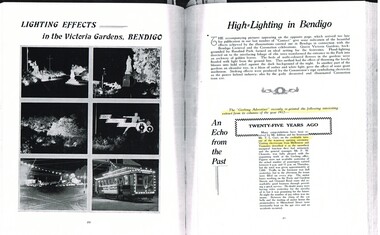
Document - Photocopy, M. Sayers, "Lighting Effects in the Victoria Gardens, Bendigo", 2000?
... Article titled "Lighting Effects in the Victoria Gardens... of celebratory flood lighting in Bendigo, Victoria Gardens during 1937 ...Article titled "Lighting Effects in the Victoria Gardens, Bendigo", "High = Lighting in Bendigo", "An Echo from the Past". The article has photos of celebratory flood lighting in Bendigo, Victoria Gardens during 1937, for the Bendigo Carnival and Coronation Celebrations. Festivities were held in Victoria Gardens. Notes the Coronation tram car, illuminated and decorated. Has a photo of No. 21 outside the depot. Reprint of an extract from the Geelong Advertiser in 1912, 25 years ago of the opening of the Geelong tramways, passenger numbers and celebrations of the event. Record revised 3/4/2019 to add digital images with those from Andrew Cook CD. See item 9099 for the image of tram 21. Page 35 - records the relocation of Mr. A N Mercer who was involved in the reconstruction of Ballarat and Bendigo Tramways has transferred to the Flinders St Drawing Office. Each item had a thin strip of paper attached by staple to the top left hand corner, giving the Vol. No. details.Yields information about tram 21 as the Bendigo Coronation tram in Photocopy of an article in the State Electricity Commission of Victoria Magazine, Contact, Vol 2, No. 2, Aug. 1937. One A3 sheet.trams, tramways, sec, geelong, decorated trams, bendigo, opening, coronation -
 Bayside Gallery - Bayside City Council Art & Heritage Collection
Painting - oil on linen, Victoria Reichelt, Flood 3, 2014
oil on linencardboard box, paper, water, documents, painting, victoria reichelt, fragile, photorealist, archive -
Kew Historical Society Inc
Archive (series) - Subject File, Baby Health Centres, 1958
Various PartiesReference, Research, InformationKHS OrderSubject file containing photocopies and a journal published by the RHSV (69:1, June 1998). The article, ‘Baby Boon: The Infant Welfare Movement in Victoria’, was written by Margaret Flood. While the article only makes one reference to milk supplied by Kew dairies, it contains useful descriptions of the role of Baby Health Centres and their staff. A newspaper article/clipping (1991) refers to the establishment of the Baby Changing Room in Walpole Street. There is also a photocopy of W D Vaughan’s text on Baby Health Centres in Kew (1960).infant welfare centres - kew (vic.)infant welfare centres - kew (vic.) -
 Kew Historical Society Inc
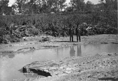
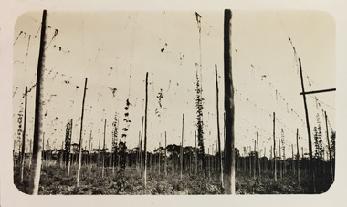
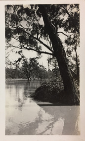
Photograph - Yarra at Kew, 1925
Henry Beater Christian (1886-1962) , was a descendant of one of the earliest settler families in Kew. Employed at the Kew Asylum as a 'public servant', he was a skilled amateur photographer, photographing numerous scenes in Kew and on his travels around Victoria. The majority of his photographs date from 1916 to 1929. His finest photographs are housed in two photograph albums. Digital copy of a photograph from page 4 of the 47-page photograph album containing 261 gelatinous silver images, loaned by Diane Washfold with permission given to digitise and hold a copy in our collection. This photograph of hop farming coveys the various uses for which low lying fertile flood prone land beside the Yarra River was used."Yarra at Kew"henry beater christian (1886-1962), landscape photography, kew (vic.) — yarra river, christian-washfold collection, photograph albums, agriculture, hop farms -
 Kew Historical Society Inc
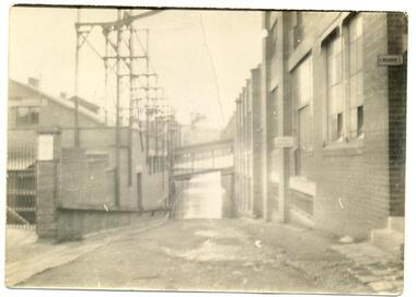
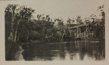
Photograph - Flood, Zig-Zag, Kew, 1924
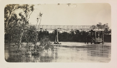
Henry Beater Christian (1886-1962) , was a descendant of one of the earliest settler families in Kew. Employed at the Kew Asylum as a 'public servant', he was a skilled amateur photographer, photographing numerous scenes in Kew and on his travels around Victoria. The majority of his photographs date from 1916 to 1929. His finest photographs are housed in two photograph albums. A fine and clear view of the Zig-Zag Bridge across the Yarra River.Digital copy of a photograph from page 5 of the 47-page photograph album containing 261 gelatinous silver images, loaned by Diane Washfold with permission given to digitise and hold a copy in our collection. This is a photograph of the 1870s Zig-Zag Bridge that linked the Yarra Bend and Kew Asylums. The Bridge was demolished in 1929."Flood / Zig-Zag / Kew / 1.24"henry beater christian (1886-1962), landscape photography, kew (vic.) — yarra river, christian-washfold collection, photograph albums, zig-zag bridge -
 Kew Historical Society Inc
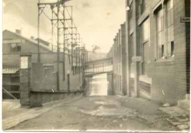
Photograph - Flood, Zig-Zag, Kew, 1924
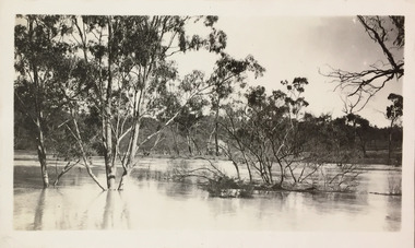
Henry Beater Christian (1886-1962) , was a descendant of one of the earliest settler families in Kew. Employed at the Kew Asylum as a 'public servant', he was a skilled amateur photographer, photographing numerous scenes in Kew and on his travels around Victoria. The majority of his photographs date from 1916 to 1929. His finest photographs are housed in two photograph albums. Digital copy of a photograph from page 5 of the 47-page photograph album containing 261 gelatinous silver images, loaned by Diane Washfold with permission given to digitise and hold a copy in our collection. This is a photograph of a section of the river at Kew during a flood in January 1924."Flood / Zig-Zag Kew / 1.24"henry beater christian (1886-1962), landscape photography, kew (vic.) — yarra river, christian-washfold collection, photograph albums, floods -- yarra river -- kew (vic.) -
 Kew Historical Society Inc
Photograph - Flood, Zig-Zag, Kew, 1924
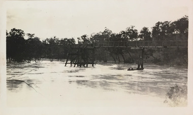
Henry Beater Christian (1886-1962) , was a descendant of one of the earliest settler families in Kew. Employed at the Kew Asylum as a 'public servant', he was a skilled amateur photographer, photographing numerous scenes in Kew and on his travels around Victoria. The majority of his photographs date from 1916 to 1929. His finest photographs are housed in two photograph albums. Digital copy of a photograph from page 5 of the 47-page photograph album containing 261 gelatinous silver images, loaned by Diane Washfold with permission given to digitise and hold a copy in our collection. This is a photograph of the Zig-Zag Bridge that crossed the river at Kew during a flood in January 1924. The contrast in the photo is compromised because of the weather conditions and due to shooting into the light."Flood / Zig-Zag Kew / 1.24"henry beater christian (1886-1962), landscape photography, kew (vic.) — yarra river, christian-washfold collection, photograph albums, floods -- yarra river -- kew (vic.), zig-zag bridge -
 Kew Historical Society Inc
Photograph - Flood, Zig-Zag, Kew, 1924
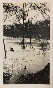
Henry Beater Christian (1886-1962) , was a descendant of one of the earliest settler families in Kew. Employed at the Kew Asylum as a 'public servant', he was a skilled amateur photographer, photographing numerous scenes in Kew and on his travels around Victoria. The majority of his photographs date from 1916 to 1929. His finest photographs are housed in two photograph albums. Digital copy of a photograph from page 5 of the 47-page photograph album containing 261 gelatinous silver images, loaned by Diane Washfold with permission given to digitise and hold a copy in our collection. This is a photograph of the river at Kew during a flood in January 1924. A section of the Zig-Zag Bridge can be seen in the distance. "Flood / Zig-Zag Kew / 1.24"henry beater christian (1886-1962), landscape photography, kew (vic.) — yarra river, christian-washfold collection, photograph albums, floods -- yarra river -- kew (vic.), zig-zag bridge -
 Kew Historical Society Inc
Photograph - Flood, Zig-Zag, Kew, 1924
Henry Beater Christian (1886-1962) , was a descendant of one of the earliest settler families in Kew. Employed at the Kew Asylum as a 'public servant', he was a skilled amateur photographer, photographing numerous scenes in Kew and on his travels around Victoria. The majority of his photographs date from 1916 to 1929. His finest photographs are housed in two photograph albums. Digital copy of a photograph from page 5 of the 47-page photograph album containing 261 gelatinous silver images, loaned by Diane Washfold with permission given to digitise and hold a copy in our collection. This is a photograph of the river at Kew during a flood in January 1924."Flood / Zig-Zag Kew / 1.24"henry beater christian (1886-1962), landscape photography, kew (vic.) — yarra river, christian-washfold collection, photograph albums, floods -- yarra river -- kew (vic.) -
 Kew Historical Society Inc
Photograph - Flood, Zig-Zag, Kew, 1924
Henry Beater Christian (1886-1962) , was a descendant of one of the earliest settler families in Kew. Employed at the Kew Asylum as a 'public servant', he was a skilled amateur photographer, photographing numerous scenes in Kew and on his travels around Victoria. The majority of his photographs date from 1916 to 1929. His finest photographs are housed in two photograph albums. Digital copy of a photograph from page 5 of the 47-page photograph album containing 261 gelatinous silver images, loaned by Diane Washfold with permission given to digitise and hold a copy in our collection. This is a photograph of the river at Kew during a flood in January 1924. The bridge is the Zig-Zag Bridge that linked the Yarra Bend and Kew Asylums (built 1870s-demolished 1929)."Flood / Zig-Zag Kew / 1.24"henry beater christian (1886-1962), landscape photography, kew (vic.) — yarra river, christian-washfold collection, photograph albums, floods -- yarra river -- kew (vic.), zig-zag bridge