Showing 173 items matching "victoria. lands department"
-
 Bendigo Historical Society Inc.
Map - GOORNONG : COUNTY OF BENDIGO, September 1943
Map. Goornong, County of Bendigo, Egerton, Bagshot, Ellesmere, Muskerry, Campaspe, Nolan, Campaspe River, Town of Goornong. By authority : H.E. Daw, Government Printer, Melbourne. Drawn and reproduced at the Department of Lands and Survey, Melbourne, Victoria. September 1943, Price 2/-. (number 44 in map cupboard 1)H.E. Daw, Government Printer, Melbourne.map, bendigo, goornong -
Bendigo Historical Society Inc.
Map - HUNTLY : COUNTY OF BENDIGO, August 1954
Map. Huntly, County of Bendigo. Whirrakee, Bagshot, Wellsford, Nerring, Neilborough, Township of Huntly. Drawn and reproduced at the Department of Lands and Survey, Melbourne, Victoria. August 1954. Price 2/-. By authority W.M. Houston, Government Printer. (number 42 in map cupboard 1)W.M. Houston, Govt. Printer.map, bendigo, huntly -
Bendigo Historical Society Inc.
Map - WOODSTOCK : COUNTY OF BENDIGO, 4-7-35
Map. Woodstock, County of Bendigo, Derby, Leichardt, Marong, Shelbourne, Laanecoorie, Tarnagulla. Bradford Creek, Maldon and Laanecoorie Railway. Drawn and reproduced at the Department of Lands and Survey, Melbourne, Victoria.4-7-35. Price 2/-. By authority H.J. Green,Govt. Printer. (number 41 in map cupboard 1)H.J. Green, Govt. Printer.map, bendigo, woodstock -
Bendigo Historical Society Inc.
Map - YALLOOK : COUNTY OF BENDIGO, 30-1-28
Map. Yallook, County of Bendigo, L4942, Talambe, Tandarra, Neilborough, Yarraberb, Salisbury, Pompapiel. Drawn and reproduced at the Department of Lands and Survey, Melbourne, Victoria. 30-1-28. H.J. Green, Govt. Printer, Melbourne. (number 18 in map cupboard 1)H.J. Green, Govt. Printer.map, bendigo, yallook -
Bendigo Historical Society Inc.
Map - NERRING : COUNTY OF BENDIGO, August 1952
Map. Nerring, County Of Bendigo. Yarraberb, Neilborough, Huntly, Sandhurst, Leichardt, Marong. Drawn and reproduced at the Department of Lands and Survey, Melbourne,Victoria. August 1952, Price 2/-. By Appointment J.J. Gourley, Government Printer, Melbourne. (number 0 in map cupboard 1)J.J. Gourley,Government Printermap, bendigo, nerring -
 Bendigo Historical Society Inc.
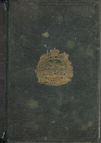
Book - DEPARTMENT OF AGRICULTURE SECOND ANNUAL REPORT 1874
Dark green cover, embossed on front 'Department of Agriculture Victoria' enclosed in circular design. Report to the Minister of Lands and Agriculture, 1874 on the proceedings of the Department, 363 pages. Written on front page in black ink "Mr H.P. Smith, Strathfieldsaye' Includes information on agricultural education, Australian grasses, diseases among stock, orange cuture, wood boring beetles, apples meteorologyof Victoria, worm diseased in sheep, sericulture, white eyebrowed woodswallow, flax, vines and wine industry, fencing and impounding. Contains information about Strathfieldsaye vigneron Messrs Bruhn and T Strachan of Axedale. Extensive metereological data for 1873 included; Sandhurst data described in depth.Variousgovernment, state, department of agriculture -
 Bendigo Historical Society Inc.
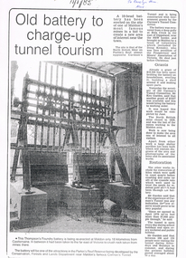
Newspaper - LONG GULLY HISTORY GROUP COLLECTION: 10 HEAD BATTERY
Copy of a newspaper article titled Old battery to charge-up tunnel tourism. Date written on the paper is 11/1/85. The Thompson's Foundry Battery was re-erected in the Parkin's Reef Reserve after being used at Bola Creek near the NSW border. A team of volunteers and a Grant had it moved to Maldon where it was set up and the area made attractive for tourists.bendigo, history, long gully history group, the long gully history group - 10 head battery, thompson's foundry battery, parkin's reef reserve, conservation forests and lands department, carman's tunnel, north british mine, parkins reef, carman's tunnel committee, dr doug kemsley, prospectors' and miners' association of victoria, mr ken garden -
Bendigo Historical Society Inc.
Document - HARRY BIGGS COLLECTION: OLD POLICE BARRACKS, 5/6/70
Document. Harry Biggs Collection. A letter on Public Works Department Victoria letterhead from G. Serpell Director General to Mr H. Biggs, Treasurer Royal Historical of Victoria (Bendigo Branch) dated 5th June 1970. In the letter he is stating The Depart. Of Crown Lands & Survey is investigating the future use & control of the old Police Barracks building.G. Serpell Director Generalorganization, club/society, community, harry biggs collection, old police barracks -
Bendigo Historical Society Inc.
Map - VICTORIA, Circa 1926
Map: Map showing Counties, including Railway lines and Geographic features. Compiled and engraved at the Department of Lands and Survey Melbourne, Revised October 1926 ( number 184 in Map Cupboard 1)map, victoria, counties, counties of victoria, geographic features -
 Victorian Interpretive Projects Inc.
Photograph - Colour, Clare Gervasoni, Ebenezer Mission, Antwerp, 2013, 2013
The Ebenezer Mission Station is situated by the Wimmera River and was established by Moravian missionaries as the Lake Hindmarsh Aboriginal Reserve in 1859. At its peak more than 100 people lived and worked on the mission in more than 20 buildings. The Mission closed in 1900 and was returned to the Lands Department in 1904. The church was established in the 1870s and the cemetery includes hundreds of unmarked burials. In 1961 the National Trust (Victoria) received a letter from the Horsham Historical Society expressing concern for the future of the Mission buildings. By 1971 the National Trust was managing the site. It was fenced, connected to power and the church was restored. In the mid-1970s the gravestones were in a bad state of repair. Stonemason James McCauley worked on the stones for 2 weeks. In 1991 the church was handed over to the Goolum Goolum Aboriginal Co-operative to manage. On 05 December 2013 the National Trust handed over the freehold of the Mission site. Moravian missionary Revd Paul Bogisch and his wife Amalie are buried in the cemetery. A number of colour digital photographs showing buildings on the former Ebenezer Mission at Antwerp.ebenezer, bogisch, goolum goolum, goolum, national trust, national trust (victoria), lake hindmarsh, lake hindmarsh aboriginal reserve, moravian, mission, missionary -
 St Kilda Historical Society
Photograph - Photo map, 28/01/1951
One of a series of photo-maps produced for the Department of Crown Lands and Survey (1857-1983). For correlation with a current map, and access to other historical photo maps of Victoria, see the Historic Photo-Maps Index published by the Department of Environment, Land, Water and Planning at https://services.land.vic.gov.au/DELWPmaps/historical-photomaps/Black and white aerial photograph1424-45 SECRET 534 Run 18 Lens 12" Melbourne Metropolitan 12150 28.1.51 M639albert park, st kilda junction, st kilda pier, catani gardens, st kilda, prahran, albert park lake, 1951, middle park, st kilda beach, windsor -
 St Kilda Historical Society
Photograph - Photo map, 17/01/1951
One of a series of photo-maps produced for the Department of Crown Lands and Survey (1857-1983). For correlation with a current map, and access to other historical photo maps of Victoria, see the Historic Photo-Maps Index published by the Department of Environment, Land, Water and Planning at https://services.land.vic.gov.au/DELWPmaps/historical-photomaps/Black and white aerial photograph1414-21 538 Run 19 Lens 12" Melbourne Metropolitan 12150 17.1.51 M586st kilda, st kilda botanical gardens, peanut farm, elwood, 1951, point ormond, elwood canal, st kilda beach -
 St Kilda Historical Society
Photograph - Photo map, 28/01/1951
One of a series of photo-maps produced for the Department of Crown Lands and Survey (1857-1983). For correlation with a current map, and access to other historical photo maps of Victoria, see the Historic Photo-Maps Index published by the Department of Environment, Land, Water and Planning at https://services.land.vic.gov.au/DELWPmaps/historical-photomaps/Black and white aerial photograph1424-118 534 Run 20 Lens 12" Melbourne Metropolitan 12150 18.1.51M639elwood, point ormond, elwood park, elsternwick park, elwood beach, 1951 -
 St Kilda Historical Society
Photograph - Photo map, 17/01/1951
One of a series of photo-maps produced for the Department of Crown Lands and Survey (1857-1983). For correlation with a current map, and access to other historical photo maps of Victoria, see the Historic Photo-Maps Index published by the Department of Environment, Land, Water and Planning at https://services.land.vic.gov.au/DELWPmaps/historical-photomaps/Black and white aerial photograph1414-20 538 Run 19 Lens 12" Melbourne Metropolitan 12150 17.1.51 M586elwood, elsternwick, st kilda east, balaclava, ripponlea, 1951 -
 St Kilda Historical Society
Photograph - Photo map, 28/01/1951
One of a series of photo-maps produced for the Department of Crown Lands and Survey (1857-1983). For correlation with a current map, and access to other historical photo maps of Victoria, see the Historic Photo-Maps Index published by the Department of Environment, Land, Water and Planning at https://services.land.vic.gov.au/DELWPmaps/historical-photomaps/Black and white aerial photograph1424-44 534 Run 18 Lens 12" Melbourne Metropolitan 12150 28.1.51 M639 -
 St Kilda Historical Society
Photograph - Photo map, 28/01/1951
One of a series of photo-maps produced for the Department of Crown Lands and Survey (1857-1983). For correlation with a current map, and access to other historical photo maps of Victoria, see the Historic Photo-Maps Index published by the Department of Environment, Land, Water and Planning at https://services.land.vic.gov.au/DELWPmaps/historical-photomaps/Black and white aerial photograph1424-43 534 Run 18 Lens 12" Melbourne Metropolitan 12150 28.1.51 M639armadale, malvern, st kilda cemetery, caulfield north, st kilda east, 1951 -
 St Kilda Historical Society
Photograph - Photo map, 30/01/1960
One of a series of photo-maps produced for the Department of Crown Lands and Survey (1857-1983). For correlation with a current map, and access to other historical photo maps of Victoria, see the Historic Photo-Maps Index published by the Department of Environment, Land, Water and Planning at https://services.land.vic.gov.au/DELWPmaps/historical-photomaps/Black and white aerial photographVic 1093-62 Melbourne & Metropolitan Project Run 21 30.1.60 Lens 10" 8.200middle park, albert park, catani gardens, st kilda west, 1960 -
 St Kilda Historical Society
Photograph - Photo map, 30/01/1960
One of a series of photo-maps produced for the Department of Crown Lands and Survey (1857-1983). For correlation with a current map, and access to other historical photo maps of Victoria, see the Historic Photo-Maps Index published by the Department of Environment, Land, Water and Planning at https://services.land.vic.gov.au/DELWPmaps/historical-photomaps/Black and white aerial photographVic 1093-60 Melbourne & Metropolitan Project Run 21 30.1.60 Lens 10" 8.200st kilda, albert park, prahran, windsor, south yarra, 1960 -
 St Kilda Historical Society
Photograph - Photo map, 30/01/1960
One of a series of photo-maps produced for the Department of Crown Lands and Survey (1857-1983). For correlation with a current map, and access to other historical photo maps of Victoria, see the Historic Photo-Maps Index published by the Department of Environment, Land, Water and Planning at https://services.land.vic.gov.au/DELWPmaps/historical-photomaps/Black and white aerial photographVic 1092-36 Melbourne & Metropolitan Project Run 22 30.1.60 Lens 10" 8.200st kilda, st kilda pier, st kilda beach, catani gardens, 1960 -
 St Kilda Historical Society
Photograph - Photo map, 30/01/1960
One of a series of photo-maps produced for the Department of Crown Lands and Survey (1857-1983). For correlation with a current map, and access to other historical photo maps of Victoria, see the Historic Photo-Maps Index published by the Department of Environment, Land, Water and Planning at https://services.land.vic.gov.au/DELWPmaps/historical-photomaps/Black and white aerial photographVic 1092-38 Melbourne & Metropolitan Project Run 22 30.1.60 Lens 10" 8.200st kilda, st kilda beach, st kilda pier, catani gardens, 1960, st kilda botanical gardens, peanut farm -
 St Kilda Historical Society
Photograph - Photo map, 30/01/1960
One of a series of photo-maps produced for the Department of Crown Lands and Survey (1857-1983). For correlation with a current map, and access to other historical photo maps of Victoria, see the Historic Photo-Maps Index published by the Department of Environment, Land, Water and Planning at https://services.land.vic.gov.au/DELWPmaps/historical-photomaps/Black and white aerial photographVic 1092-40 Melbourne & Metropolitan Project Run 22 30.1.60 Lens 10" 8.200st kilda east, balaclava, ripponlea, st kilda cemetery, 1960 -
 St Kilda Historical Society
Photograph - Photo map, 30/01/1960
One of a series of photo-maps produced for the Department of Crown Lands and Survey (1857-1983). For correlation with a current map, and access to other historical photo maps of Victoria, see the Historic Photo-Maps Index published by the Department of Environment, Land, Water and Planning at https://services.land.vic.gov.au/DELWPmaps/historical-photomaps/Black and white aerial photographVic 1092-42 Melbourne & Metropolitan Project Run 22 30.1.60 Lens 10" 8.200malvern, caulfield, caulfield park, 1960 -
 St Kilda Historical Society
Photograph - Photo map, 30/01/1960
One of a series of photo-maps produced for the Department of Crown Lands and Survey (1857-1983). For correlation with a current map, and access to other historical photo maps of Victoria, see the Historic Photo-Maps Index published by the Department of Environment, Land, Water and Planning at https://services.land.vic.gov.au/DELWPmaps/historical-photomaps/Black and white aerial photographVic 1091-112 Melbourne & Metropolitan Project Run 23East 30.1.1960 Lens 10" 8.200elwood, point ormond, elwood park, elwood canal, 1960 -
 St Kilda Historical Society
Photograph - Photo map, 30/01/1960
One of a series of photo-maps produced for the Department of Crown Lands and Survey (1857-1983). For correlation with a current map, and access to other historical photo maps of Victoria, see the Historic Photo-Maps Index published by the Department of Environment, Land, Water and Planning at https://services.land.vic.gov.au/DELWPmaps/historical-photomaps/Black and white aerial photographVic 1091-110 Melbourne & Metropolitan Project Run 23East 30.1.60 Lens 10" 8.200elwood, elsternwick, elsternwick park, ripponlea, st kilda east, caulfield, balaclava, 1960 -
 St Kilda Historical Society
Photograph - Photo map, 30/01/1960
One of a series of photo-maps produced for the Department of Crown Lands and Survey (1857-1983). For correlation with a current map, and access to other historical photo maps of Victoria, see the Historic Photo-Maps Index published by the Department of Environment, Land, Water and Planning at https://services.land.vic.gov.au/DELWPmaps/historical-photomaps/Black and white aerial photographVic 1091-1 Melbourne & Metropolitan Project Run 24East 30.1.60 Lens 10" 8.200elwood, elwood beach, elwood park, 1960 -
 St Kilda Historical Society
Photograph - Photo map, 30/01/1960
One of a series of photo-maps produced for the Department of Crown Lands and Survey (1857-1983). For correlation with a current map, and access to other historical photo maps of Victoria, see the Historic Photo-Maps Index published by the Department of Environment, Land, Water and Planning at https://services.land.vic.gov.au/DELWPmaps/historical-photomaps/Black and white aerial photographVic 1091-2 Melbourne & Metropolitan Project Run 24East 30.1.60 Lens 10" 8.200elwood, elwood park, elwood beach, elsternwick park, 1960 -
 St Kilda Historical Society
Photograph - Photo map, 3/3/1964
One of a series of photo-maps produced for the Department of Crown Lands and Survey (1857-1983). For correlation with a current map, and access to other historical photo maps of Victoria, see the Historic Photo-Maps Index published by the Department of Environment, Land, Water and Planning at https://services.land.vic.gov.au/DELWPmaps/historical-photomaps/Black and white aerial photographVic 1833 Melbourne 1963 Project Run 15 3.3.64 Lens 205 152.70 M/M 5.150 56prahran, fawkner park, south yarra, albert park, 1964 -
 St Kilda Historical Society
Photograph - Photo map, 14/12/1963
One of a series of photo-maps produced for the Department of Crown Lands and Survey (1857-1983). For correlation with a current map, and access to other historical photo maps of Victoria, see the Historic Photo-Maps Index published by the Department of Environment, Land, Water and Planning at https://services.land.vic.gov.au/DELWPmaps/historical-photomaps/Black and white aerial photographVic 1807 Melbourne 1963 Project Run 16 14.12.63 Lens 205 152.70 M/M 5.150 179st kilda, prahran, albert park, st kilda east, balaclava, 1963 -
 St Kilda Historical Society
Photograph - Photo map, 14/12/1963
One of a series of photo-maps produced for the Department of Crown Lands and Survey (1857-1983). For correlation with a current map, and access to other historical photo maps of Victoria, see the Historic Photo-Maps Index published by the Department of Environment, Land, Water and Planning at https://services.land.vic.gov.au/DELWPmaps/historical-photomaps/Black and white aerial photographVic 1807 Melbourne 1963 Project Run 16 14.12.63 Lens 205 152.70 M/M 5.150 181st kilda cemetery, caulfield north, st kilda east, armadale, malvern, 1963 -
 St Kilda Historical Society
Photograph - Photo map, 14/12/1963
One of a series of photo-maps produced for the Department of Crown Lands and Survey (1857-1983). For correlation with a current map, and access to other historical photo maps of Victoria, see the Historic Photo-Maps Index published by the Department of Environment, Land, Water and Planning at https://services.land.vic.gov.au/DELWPmaps/historical-photomaps/Black and white aerial photographVic 1807 Melbourne 1963 Project Run 17 14.12.63 Lens 205 152,70 M/M 5.150 34st kilda, peanut farm, point ormond, st kilda marina, st kilda pier, 1963