Showing 78 items matching "volcanic geology"
-
 Federation University Historical Collection
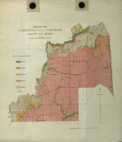
Plan - Map, Mines Department, Parish of Narmbool and part of Cargerie, County of Grant, 1892, 06/1992
This map shows the position of the homestead on the Narmbool Pre-emptive Right, volcanic craters, stock reserve, quarry and geological eras,Geological map showing Narmbool and part of Cargerie in the County of Grant in five colours, predominantly pink.narmbool, cargerie, narmbool pre-emptive right, williamson's creek, leigh river, green hill, collyer's hill, volcano, crater, krause, ferdinand krause -
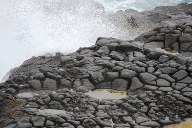
 Ballarat Heritage Services
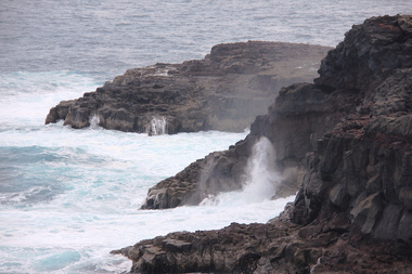
Digital photograph, Lisa Gervasoni, Cape Bridgewater, c2015
cape bridgewater, geology, ocean, coastal, landscape, seascape, blowhole, volcanic rock -
 Ballarat Heritage Services
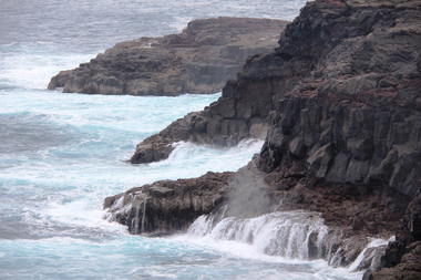
Digital photograph, Lisa Gervasoni, Cape Bridgewater, c2015
Colour photograph of the coastline at Cape Bridgewater, Victoria. cape bridgewater, geology, ocean, coastal, landscape, seascape, blowhole, volcanic rock -
 Ballarat Heritage Services
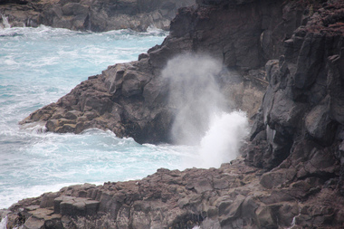
Digital photograph, Lisa Gervasoni, Cape Bridgewater, c2015
cape bridgewater, geology, ocean, coastal, landscape, seascape, blowhole, volcanic rock -
 Ballarat Heritage Services
Digital photograph, Lisa Gervasoni, Cape Bridgewater, c2015
cape bridgewater, geology, ocean, coastal, landscape, seascape, blowhole, volcanic rock -
 Ballarat Heritage Services
Digital photograph, Lisa Gervasoni, Cape Bridgewater, c2015
cape bridgewater, geology, ocean, coastal, landscape, seascape, blowhole, volcanic rock -
 Sunbury Family History and Heritage Society Inc.
Photograph, Bulla Primary School, Hanging Rock, 1995
... . Hanging Rock is an important geological and volcanic structure ...In 1995, the upper school students from Bulla Primary School attended a camp at Hanging Rock Reserve which is part of the Macedon Ranges. At this camp the students were shown basic rock climbing skills and explored the rock for its interesting geological formations. Hanging Rock, also known as Mount Diogenes, is the traditional land of the Dja Dja Wurrung, Woi Wurrung and Taungurung people. It is a mamelon formed when magma poured from a vent and congealed. There are interesting rock functions at the site such as the Colonnade, the Eagle and the UFO. The highest point on the rock is 718metres above sea level and 105 meters above the land at its base.Hanging Rock is an important geological and volcanic structure in the Macedon Ranges area and in central Victoria. A non-digital coloured photograph of three holiday cabins and a barbecue in a bushland setting. A red car is parked outside one of the cabins as well as two permanent picnic tables.hanging rock, mount diogenes, mamelons, volcanoes, school camps, bulla primary school -
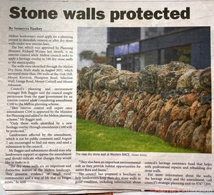 Melton City Libraries
Newspaper, Stone Walls protected, 2015
Dry stone construction as a technique is used for much more than paddock walls. Across the volcanic plains of western Victoriaare marvelous sheep dips, stock loading ramps, huts, dams, retaining walls, and the rich and largely undiscovered heritage of indigenous dry stone structures. Dry stone walls indicate many aspects of our rural environment; the geological beginnings of the way the landscape was created, the patterns of early settlement by pastoralists and squatters, the types of stock that grazed the land and the methods of cattle and sheep management, of the efforts to thwart the spread of rabbits .... "For the casual but interested observer dry stone walls are good to look at, to photograph, to get up alongside and see the way they are constructed, to appreciate the varying shapes and sizes of stones and learn of the techniques of keeping often quite rounded stones in place. Apart from walls and other dry stone structures on grazing land we can also see dry stone techniques used in other places and in other phases of our history. Indigenous Australians have built, and continue to build, structures for shelter or hunting or trapping eels and fish in rivers and estuaries around the country. At spots around our coast line there is evidence of simple stone structures built by early maritime explorers. Prospectors in early mining encampments used dry stone construction to build retaining walls or the low walls of rudimentary shelters. If the future of dry stone walls in the Australian landscape is to be assured. wall owners and local governments have to accept and embrace their custodial role in assuring the preservation and celebration of walls. This is not an easy task, but, along with putting the necessary statutory mechanisms to ensure their retention, it is a task that must be pursued. The Dry Stone Walls Association of Australia has as its primary goal the increase in awareness of wall owners and local governments of the importance of dry stone walls. It also seeks to increase the level of training of skilled and semi skilled wallers, and the gaining of rudimentary skills by farmers so that they can maintain their own walls". Melton Star Weekly article about the Stone Wallslandscapes of significance -
 The Beechworth Burke Museum
Geological specimen - Olivine Crystals, Unknown
Olivine is mostly found on the Earth's surface in igneous rocks that are dark-coloured. It is common at divergent plate boundaries and at warm spots, such as volcanic areas. It crystalises and forms during the cooling of magma. Olivine is used in refractory sand, bricks, and gemstones. Olivine has been found on a number of meteorites, which might have originated from large asteroids or the mantle of a now-destroyed planet. This olivine crystal is thought to originate from Mount Noorat, with speculation that it could have originated from Mount Shadwell. Mount Noorat is a dormant volcano cone located in the Newer Volcanics Province of Victoria. Mount Noorat belongs to the Kirrae Wuurong people, who used the Mount as a place for meetings and gatherings prior to European settlement. Contact was first made between European settlers and the Indigenous people in 1841. The Mount has mostly been used for cattle and sheep grazing. Mount Shadwell is a well-known source of olivine and is the highest of a gathering of volcanic cones. The New Volcanic Province is located in South East Australia and covers 15000 square kilometres. It contains 400 explosive vents and small shield volcanoes. The last eruption is thought to have occurred 5000 years ago at Mount Gambier and Mount Schank. This olivine crystal has been identified as a volcanic bomb, which is a molten rock which was pushed out and ejected into the air when a volcano reupts. A rock needs to be larger than 65 mm in diameter to be classified as a volcanic bomb. This olivine volcanic bomb and its locality is historically and socially significant. The olivine was found in the Newer Volcanic Province, an area which contains over 400 dormant volcanoes. This olivine is one part of a volcanic bomb, which would have ejected when magma erupted out of a volcano. This specimen is part of a larger collection of geological and mineral specimens collected from around Australia (and some parts of the world) and donated to the Burke Museum between 1868-1880. A large percentage of these specimens were collected in Victoria as part of the Geological Survey of Victoria that begun in 1852 (in response to the Gold Rush) to study and map the geology of Victoria. Collecting geological specimens was an important part of mapping and understanding the scientific makeup of the earth. Many of these specimens were sent to research and collecting organisations across Australia, including the Burke Museum, to educate and encourage further study.A solid iron-magnesium silicate mineral with shades of green and brownburke museum, beechworth, geological, geological specimen, olivine, igneous rock, volcanic, gemstones, volcanic bomb, meteorites, asteroids, plantes, mount noorat, mount shadwell, indigenous, kirrae wuurong people, newer volcanics province, victoria, european settlement, eruption -
 The Beechworth Burke Museum
Geological specimen - Slice Dendrites on Sandstone, Unknown
Dendrites are deposits of black minerals, typically manganese oxides that precipitated from water seeping through fractures in fine-grain rocks like a sandstone or limestone. Dendrites are much less regular than plant fossils and lacks vein structures. The manganese cryztallizes through the process called 'supercooling'. Some samples of dendrites occur in volcanic rocks in the Lilydale district, east of Melbourne. Sandstones are made of tiny sand grains that may have been deposited in the sea and later formed together. Most sandstones are made of quartz which are chemically-resistant minerals. This particular specimen was donated by Alfred Selwyn in 1868 as part of the Geological Survey of Victoria. It is connected to the original 1875 catalogue on Geological Specimen with number 189 'Quartz Crystals_Quartz Crystals (two are polished)'Dendrites on sandstones This specimen is an important contribution to the geological history of Victoria, as well as its links to the 1868 Geological Survey of Victoria. This specimen is part of larger collection of significant geological specimens in the Burke Museum that was collected from around the world between 1868-1880. A large percentage of these specimens were collection as part of the Geological Survey of Victoria 1852-1974. The Geological Survey of Victoria was an organisation founded in response to the Victorian gold rush to explore the geological and mineral resources and to record a detailed map of the state. It was headed by British geologist, Alfred Richard Cecil Selwyn (1824-1902), who was responsible for issuing over 60 geological maps during his 17 years as director. These maps were all hand-drawn and coloured and became the benchmark for accuracy for geological mapping. Collecting geological specimens was an important part of mapping and understanding the scientific makeup of the earth. Many of these specimens were sent to research and collecting organisations across Australia, including the Burke Museum, to educate and encourage further study. A hand-sized slice of light brown sandstone with dendrites formed from crystallized manganese oxide.Existing label: Not sure what / 'Slica dondrites' / means. / Sample is sandstone and original label / identifies it as from / the Grampians near Stawell. / C. Willman / 15/4/21 Other label: [illegible] / stone [ illegible] / from Grampians Stawell / 1894 /geological specimen, geology, geology collection, burke museum, beechworth, dendrites, sandstones, quartz, lilydale district, geological survey of victoria, grampians, victoria rocks, minerals, rocks, manganese oxides, alfred selwyn -
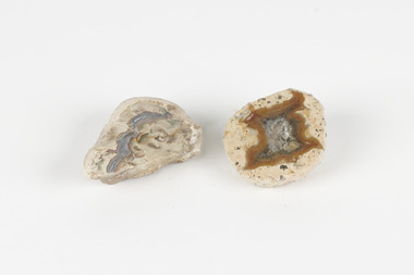 The Beechworth Burke Museum
Geological specimen - Thunderegg agates, Unknown
Thunderegg Agates are formed within rhyolite volcanic ash layers. They are rough spherical shapes, varying in size from less than an inch to over a metre long. Thundereggs usually contain centres of chalcedony which may have been fractured followed by deposition of agate, jasper or opal, either uniquely or in combination. A unique characteristic that these specimens have is the fact that they often look like ordinary rocks on the outside, but slicing them in half and polishing them may reveal intricate patterns and colours. These particular specimens are examples of thunderegg agates. Agate is a variety of chalcedony, a cryptocrystalline form of quartz. The agate component contributes to the intriguing internal patterns of the specimens. The specific locality of these specimens is unknown but they can be found in flows of rhyolite lava. They are formed in gas pockets in the lava, which act as moulds. These specimens can be found globally, with specific locations in Germany being particularly abundant. This specimen is part of a larger collection of geological and mineral specimens collected from around Australia (and some parts of the world) and donated to the Burke Museum between 1868-1880. A large percentage of these specimens were collected in Victoria as part of the Geological Survey of Victoria that begun in 1852 (in response to the Gold Rush) to study and map the geology of Victoria. Collecting geological specimens was an important part of mapping and understanding the scientific makeup of the earth. Many of these specimens were sent to research and collecting organisations across Australia, including the Burke Museum, to educate and encourage further study.Two small solid specimens with pale, sandy-coloured exteriors and fractured internal patterns. burke museum, beechworth, geological, geological specimen, thundereggs, thundereggs agate, agate, rhyolite, rhyolite lava, volcanic ash, chalcedony, cryptocrystalline -
 Eltham District Historical Society Inc
Photograph - Digital Photograph, Alan King, Blue Lake, Plenty Gorge Park, 2008
A quarry was transformed into the Blue Lake. Published: Nillumbik Now and Then / Marguerite Marshall 2008; photographs Alan King with Marguerite Marshall.; p179 The dramatic steep-sided Plenty Gorge lies along the divide of two geological areas, and separates the Nillumbik Shire and the City of Whittlesea. On the Nillumbik side are undulating hills and sedimentary rock, and in Whittlesea, lies a basalt plain formed by volcanic action up to two million years ago. This provides the Plenty Gorge Park with diverse vegetation and habitats, making it one of Greater Melbourne’s most important refuges for threatened and significant species. The park, established in 1986, consists of around 1350 hectares, and extends 11 kilometres along the Plenty River, from Greensborough to Mernda. It provides a wildlife corridor for around 500 native plant and 280 animal species. The area’s plentiful food and water attracted the Wurundjeri Aboriginal people and then European settlers. By 1837 squatters had claimed large runs of land for their sheep and cattle. The Plenty Valley was among the first in the Port Phillip District to be settled - mainly in the less heavily timbered west - and was proclaimed a settled district in 1841.But by the late 1880s, the settlers’ extensive land clearing for animal grazing, then agriculture, depleted the Wurundjeri’s traditional food sources, which helped to drive them away. Many Wurundjeri artefacts remain (now government protected), and so far 57 sites have been identified in the park, including scarred trees, burial areas and stone artefacts. Pioneer life could be very hard because of isolation, flooding, bushfires and bushrangers. Following the Black Thursday bushfires of 1851, basalt was quarried to build more fire-resistant homes. Gold discoveries in the early 1850s swelled the population, particularly around Smugglers Gully; but food production made more of an impact. In the late 1850s wheat production supplanted grazing. In the 1860s the government made small holdings available to poorer settlers. These had the greatest effect on the district, particularly in Doreen and Yarrambat, where orchards were established from the 1880s to 1914. Links with a prominent early family are the remains of Stuchbery Farm, by the river’s edge bounded by Smugglers Gully to the north and La Trobe Road, Yarrambat, to the east. The Stuchberys moved to the valley in 1890, and the family still lives in the area. In 1890, Alfred and Ada first lived in a tent where four children were born, then Alfred built the house and outbuildings around 1896. They planted an orchard, then a market garden, and developed a dairy. The family belonged to the local Methodist and tennis communities. Their grandson Walter, opened the Flying Scotsman Model Railway Museum in Yarrambat, which his widow, Vi, continues to run. Wal was also the Yarrambat CFA Captain for 22 years until 1987. Walter sold 24 hectares in 1976 for development - now Vista Court - and in 1990, the remaining 22.6 hectares for the park. Remaining are an early stone dairy and remnants of a stone barn, a pig sty and a well. Until it was destroyed by fire in 2003, a slab hut stood on the Happy Hollow Farm site, at the southern end of the park. The hut is thought to have been built in the Depression around 1893. This was a rare and late example of a slab hut with a domestic orchard close to Melbourne. Emmet Watmough and his family first occupied the hut, followed by a succession of families, until the Bell family bought it around 1948. There they led a subsistence lifestyle for 50 years, despite encroaching Melbourne suburbia. The Yellow Gum Recreation Area includes the Blue Lake, coloured turquoise at certain times of the year. Following the 1957 bushfires, this area was quarried by Reid Quarries Pty Ltd for Melbourne’s first skyscrapers, then by Boral Australia. However in the early 1970s water began seeping into the quarry forming the Blue Lake and the quarry was closed. The State Government bought the site in 1997 and opened it as a park in 1999.This collection of almost 130 photos about places and people within the Shire of Nillumbik, an urban and rural municipality in Melbourne's north, contributes to an understanding of the history of the Shire. Published in 2008 immediately prior to the Black Saturday bushfires of February 7, 2009, it documents sites that were impacted, and in some cases destroyed by the fires. It includes photographs taken especially for the publication, creating a unique time capsule representing the Shire in the early 21st century. It remains the most recent comprehenesive publication devoted to the Shire's history connecting local residents to the past. nillumbik now and then (marshall-king) collection, blue lake, plenty gorge park -
 Eltham District Historical Society Inc
Photograph - Digital Photograph, Marguerite Marshall, Stuchbery Farm dairy, 14 March 2008
Stuchbery Farm was situated on the Plenty River bounded by Smugglers Gully to the north and La trobe Road, Yarrambat, to the east. Alan and Ada Stutchbery moved to the valley in 1890, first living in a tent where four children were born. Alfred built a home and outbuildings around 1896. They planted an orchard, then a market garden and developed a dairy. Published: Nillumbik Now and Then / Marguerite Marshall 2008; photographs Alan King with Marguerite Marshall.; p179 The dramatic steep-sided Plenty Gorge lies along the divide of two geological areas, and separates the Nillumbik Shire and the City of Whittlesea. On the Nillumbik side are undulating hills and sedimentary rock, and in Whittlesea, lies a basalt plain formed by volcanic action up to two million years ago. This provides the Plenty Gorge Park with diverse vegetation and habitats, making it one of Greater Melbourne’s most important refuges for threatened and significant species. The park, established in 1986, consists of around 1350 hectares, and extends 11 kilometres along the Plenty River, from Greensborough to Mernda. It provides a wildlife corridor for around 500 native plant and 280 animal species. The area’s plentiful food and water attracted the Wurundjeri Aboriginal people and then European settlers. By 1837 squatters had claimed large runs of land for their sheep and cattle. The Plenty Valley was among the first in the Port Phillip District to be settled - mainly in the less heavily timbered west - and was proclaimed a settled district in 1841. But by the late 1880s, the settlers’ extensive land clearing for animal grazing, then agriculture, depleted the Wurundjeri’s traditional food sources, which helped to drive them away. Many Wurundjeri artefacts remain (now government protected), and so far 57 sites have been identified in the park, including scarred trees, burial areas and stone artefacts. Pioneer life could be very hard because of isolation, flooding, bushfires and bushrangers. Following the Black Thursday bushfires of 1851, basalt was quarried to build more fire-resistant homes. Gold discoveries in the early 1850s swelled the population, particularly around Smugglers Gully; but food production made more of an impact. In the late 1850s wheat production supplanted grazing. In the 1860s the government made small holdings available to poorer settlers. These had the greatest effect on the district, particularly in Doreen and Yarrambat, where orchards were established from the 1880s to 1914. Links with a prominent early family are the remains of Stuchbery Farm, by the river’s edge bounded by Smugglers Gully to the north and La Trobe Road, Yarrambat, to the east. The Stuchberys moved to the valley in 1890, and the family still lives in the area. In 1890, Alfred and Ada first lived in a tent where four children were born, then Alfred built the house and outbuildings around 1896. They planted an orchard, then a market garden, and developed a dairy. The family belonged to the local Methodist and tennis communities. Their grandson Walter, opened the Flying Scotsman Model Railway Museum in Yarrambat, which his widow, Vi, continues to run. Wal was also the Yarrambat CFA Captain for 22 years until 1987. Walter sold 24 hectares in 1976 for development - now Vista Court - and in 1990, the remaining 22.6 hectares for the park. Remaining are an early stone dairy and remnants of a stone barn, a pig sty and a well. Until it was destroyed by fire in 2003, a slab hut stood on the Happy Hollow Farm site, at the southern end of the park. The hut is thought to have been built in the Depression around 1893. This was a rare and late example of a slab hut with a domestic orchard close to Melbourne. Emmet Watmough and his family first occupied the hut, followed by a succession of families, until the Bell family bought it around 1948. There they led a subsistence lifestyle for 50 years, despite encroaching Melbourne suburbia. The Yellow Gum Recreation Area includes the Blue Lake, coloured turquoise at certain times of the year. Following the 1957 bushfires, this area was quarried by Reid Quarries Pty Ltd for Melbourne’s first skyscrapers, then by Boral Australia. However in the early 1970s water began seeping into the quarry forming the Blue Lake and the quarry was closed. The State Government bought the site in 1997 and opened it as a park in 1999.This collection of almost 130 photos about places and people within the Shire of Nillumbik, an urban and rural municipality in Melbourne's north, contributes to an understanding of the history of the Shire. Published in 2008 immediately prior to the Black Saturday bushfires of February 7, 2009, it documents sites that were impacted, and in some cases destroyed by the fires. It includes photographs taken especially for the publication, creating a unique time capsule representing the Shire in the early 21st century. It remains the most recent comprehenesive publication devoted to the Shire's history connecting local residents to the past. nillumbik now and then (marshall-king) collection, ada stuchbery, alan stuchbery, dairy, stuchbery farm, farm buildings, yarrambat, plenty gorge park -
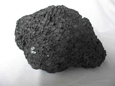 Warrnambool and District Historical Society Inc.
Geological specimen - Pumice
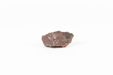
Pending further research and information nothing is known about this piece of pumice.This piece of pumice has no known local provenance but is retained for display purposes.This grey irregular shaped piece of pumice is pitted and has traces of a white substance.Nilpumice, volcanic stone -
 The Beechworth Burke Museum
Geological specimen - Calcite crystals
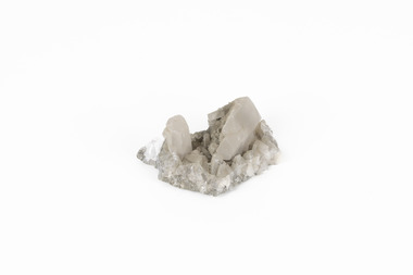
Calcite is a common mineral and is found worldwide due to it being a primary component of many other rocks such as limestone and marble. It is a softer mineral that scratches easily and is often found colourless or with a cream/white shade but may show up in colours such as red, yellow, green, and violet. In sedimentary rocks calcite is often found in the form of invertebrate shells, making it an important biomineral. Calcite is used in many industries such as farming, building, and medicine. This particular specimen was found at Broken Hill mine in Broken Hill, New South Wales, Australia. Broken Hill mine is one of the largest mines working silver and lead in Australia and at its peak employed 6500 staff across 7.5km long of land. The site was founded in 1883 by Charles Rasp, where Rasp and 6 other men from various backgrounds came together to form the first BHP mine. It has become one of the most popular mining sites due to its abundance and longevity. The ore body was created 1685 million years ago due to volcanic activity causing heated seawater to flow up through the seafloor where it mixed with the cold water creating black sulphide precipitates. These then settled back onto the seafloor forming sediment layers rich in minerals. Over time the land eroded until it was discoverable by humans.Historically this specimen is significant due to the origin of its location. Broken Hill mine has a long history in both its location and its findings and has resulted in a variety of minerals being discovered at its site. It is beneficial in the understanding of the Australian landscape over millions of years. Due to its properties, calcite today is used in a multitude of different industries such as agriculture, construction, medicine, and farming.A small sized calcium, carbon and oxygen made mineral specimen in shades cream and greycalcite, mineral, limestone, marble, sedimentary, invertebrate shells, biomineral, farming, medicine, broken hill, broken hill mine, new south wales, charles rasp, syndicate of seven, volcanic activity, black sulphide precipitates, calcite crystals, beechworth museum, indigo shire, beechworth -
 The Beechworth Burke Museum
Geological specimen - Cinnibar
Cinnabar is naturally red, but can undergo photo-oxidation to form colloidal metallic mercury at the crystal surface. This mercury may produce a silver colourationA common red ore that is often found in locations where there has been volcanic activity and has been historically used as a red pigment as a cosmetic or for colouring stone. It is commonly used today as a method of creating mercury.Red and brownish red stone with some whitish silver material at the surface CINNIBAR / (Mercury sulphide) / Locality: Spain.burke museum, beechworth, minerology, geology, geological specimin, spain, cinnabar -
 Ballarat Heritage Services
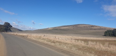
Photograph - Colour Photograph, Clare Gervasoni, Mount Greenock, 2025, 28/06/2025
... heap Mt Greenock Geological Reserve Union Mine volcanic ...Mt Greenock is an extinct volcano with lava flows associated with a deep lead. It is a tall scoria cone with a broad shallow crater open to the northwest. In the crater are blocks and bombs of scoriaceous basalt. Long lava flows extend both north and south from the cone. It is considered a significant geological site, and part of the Major Mitchell Trail, with a 1936 ‘Centenary of Major Mitchell ‘monument on the summit. The flow to the north has been eroded by McCallum Creek which is a lateral stream. On the eastern base of the cone, the stream valley exposes a lava flow and underlying sedimentary rocks. The lava flow and the scoria cone overlie the Greenock lead (a buried valley with auriferous gravels). A line of mine tailing and abandoned mining relics associated with the former Union Mine occur on the margins of the lava flow. Mount Greenock is a 120 hectare ‘Geological Reserve’, is one of the few large scoria cones on public land and contains abundant outcrop and morphological evidence of its volcanic origin. Colour Photographs of Mt Greenock, near Talbot, Victoria. The photographs were taken in winter not long after the first post drought rains. mt greenock, mount greenock, mining, mullock heap, mt greenock geological reserve, union mine, volcanic grasslands, dunach -
 Ballarat Heritage Services
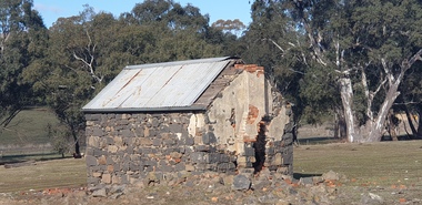
Photograph - Colour Photograph, Clare Gervasoni, Built Remains near Mount Greenock, 2025, 28/06/2025
... heap Mt Greenock Geological Reserve Union Mine volcanic ...Mt Greenock is an extinct volcano with lava flows associated with a deep lead. It is a tall scoria cone with a broad shallow crater open to the northwest. In the crater are blocks and bombs of scoriaceous basalt. Long lava flows extend both north and south from the cone. It is considered a significant geological site, and part of the Major Mitchell Trail, with a 1936 ‘Centenary of Major Mitchell ‘monument on the summit. The flow to the north has been eroded by McCallum Creek which is a lateral stream. On the eastern base of the cone, the stream valley exposes a lava flow and underlying sedimentary rocks. The lava flow and the scoria cone overlie the Greenock lead (a buried valley with auriferous gravels). A line of mine tailing and abandoned mining relics associated with the former Union Mine occur on the margins of the lava flow. Mount Greenock is a 120 hectare ‘Geological Reserve’, is one of the few large scoria cones on public land and contains abundant outcrop and morphological evidence of its volcanic origin. Colour Photographs of bluestone and brick buildings at Mt Greenock, near Talbot, Victoria. The photographs were taken in winter not long after the first post drought rains. mt greenock, mount greenock, mining, mullock heap, mt greenock geological reserve, union mine, volcanic grasslands, dunach