Showing 455 items matching "w. bridges"
-
 Phillip Island and District Historical Society Inc.
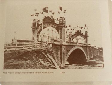
Photograph, 1867
Old Princes Bridge - 1845. copied from book "Melbourne's Yesterday's" See Phillip Island Book re Solomon West etc. Nov. 1983Sepia photograph of the old Princes Bridge Melbourne decorated for Prince Alfred's visit in 1867."Old Princes Bridge decorated for Prince Alfred's visit 1867"old princes bridge melbourne, prince alfred's visit 1867, w a mcleod -
 Mission to Seafarers Victoria
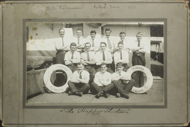
Photograph - Mounted photograph, Sepia, S.S. Tasmania's Football Team, 1922
This is a photograph of crew members that formed the football team of the S.S. Tasmania. Taken place on the deck of the ship, it is a snapshot in timeAn addition to the collection of crew photographs in the MTSV Collection with all crew members featured in the image named and dated with name of ship making it a useful research and reference image.Black and white photograph of S.S. Tasmania football team in 1922. The photograph is mounted onto a grey green cardboard frame with the text, 'S.S. "Tasmania's" Football Team 1922' on the top. The bottom reads, 'The Happy Thirteen', handwritten in black ink. The photograph itself is of 13 men in three rows, 6 on top row standing, 4 in the middle row sitting on a bench and 3 on the bottom row sitting with their legs crossed. All men have their arms crossed across their chest. On either side of the front row is a lifesaver with the text "S.S. Tasmania/Plymouth". The men are posed on the ships deck. On front mount with photograph: 'S.S "Tasmania's" Football Team 1922' / The Happy Thirteen Inscribed back:of mount names in ink : Thomas Holohay / William Bridges / James. H. Stone / George Angus / James Arthurs / George Arthurs / C. Quinell / C. (Lawrence/labence ?) / W. Manon / M. Zard / I. Ancell LT/JL ?. Chipperfield / F. Franksuniform, team, s.s. tasmania, 1922, football, crew, life buoy, crews and ships -
 Lorne Historical Society
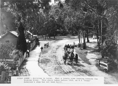
Photograph - Arriving Lorne Erskine River Bridge pre 1910
DIgital image from original b and w photo -
 Phillip Island and District Historical Society Inc.
Invitation, Oct/Nov 1969
... Phillip Island Bridge to San Remo by Hon. M. U. Porter MLA ...From a collection donated and presented by Mrs Helen Jansson. Official Invitation to opening of second Phillip Island Bridge to San Remo by Hon. M. U. Porter MLA at 2.15pm 21/11/1969.White Card with Blue Printing with rounded corners.Cr & Mrs W. G. Papworth.local history, documents, invitations, civil engineering, bridges, phillip island bridge 1969, invitation, light cardboard, printed., mrs helen jansson, second phillip island bridge 1969 -
 Greensborough Historical Society
Photograph Collection, Richard Pinn, Plenty River 1979, by Alan Pinn, 1979_
Photographs of the Plenty River Greensborough. One shows Richard Pinn walking his dog (Jah) on track by river, the second photo is a close up of the Greensborough Bluestone Bridge and steps to river. The bridge has since been demolished and the path replaced by a concrete bike/walking path.Shows the river pathways and bluestone bridge in the 1979.2 b&w photographs.plenty river, greensborough, richard pinn -
 Greensborough Historical Society
Photographs, Plenty River Flood 1974, 1974_05
Five photographs of the Plenty River in flood 1974, taken around Greensborough by June and Brian Roberts.Five photographs b & w; one note with #3#1: Plenty River may '74 flood. Flintoff St. bridge wrecked #2: [Unmarked]? #3: Plenty at Greensborough1974 flood (Note: "The house on left hand side of the picture - would it be the Medical/dental #4: Rand St. foot bridge remnants (Plenty R.) May '74 #5: Debris dumped on park by Plenty R. flood May 1974 floods, plenty river -
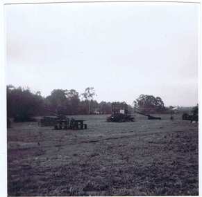
 Halls Gap & Grampians Historical Society
Photograph - B/W
Photo shows old rail bridge, surrounded by bush & passing over what appears to be a creek. Bridge is supported by wooden trestles. structures, bridges -
 Halls Gap & Grampians Historical Society
Photograph - B/W, C 1880
1880-1902 Land owned by Robert and Sarah Graham who owned a large portion of land best described as Upper Fyans Valley. At some time after 1880, they sold a parcel of the land under Sundial Peak to David Austin who built a slab hut. C1896, The land was sold to James and Amy Balmain which they named 'Bellfield' Amy was a daughter of John D/Alton who built the Stawell Water Supply System. Balmain purchased the vacant school cottage at Burnt Bridge and moved it to 'Bellfield' Over the next six years the house was enlarged to accommodate their growing family but sold in 1902 following the death of Amy Balmain.House with addition People leaving house by horse and carriage, people standing in groundsState Library Victoria, Rose's Australasian Views Victorian Series photographed and published by George Rose 123 Chapel St., Windsor, Victoriabuildings, houses, bellfield -
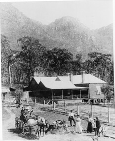
 Halls Gap & Grampians Historical Society
Photograph - B/W, C 1918
Early stages of guest houseGuest House and grounds Driveway leading up to house has a wagon in foreground before the bridge was builtAgfa Quality paper made in Germanyaccommodation, guesthouses, myrtlebank -
 Halls Gap & Grampians Historical Society
Photograph - B/W
Photo shows 2 women sedated on wooden footbridge over the Wannon riverstructures, bridges -
 Halls Gap & Grampians Historical Society
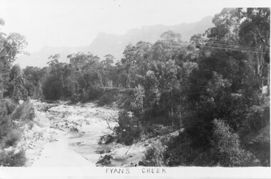
Photograph - B/W
Photo shows Fyans Creek, looking South West towards the Pinnacle. View probably taken from the bridge. Fyans Creek appears to be very wide, perhaps after a flood.scenery, fyans creek -
 Halls Gap & Grampians Historical Society
Photograph - B/W, C 1880
This photo shows the first Delley's Bridge, built to cross the Fyans Creek to provide access to Halls Gap and beyond in the 1880's. The bridge was swept away a number of times in floods. This bridge was replaced by a higher timber structure but constant erosion of the creek bank eventually led to its replacement by a timber and concrete structure. After nearly 50 years of its use, wear and tear necessitated a fourth bridge to be erected in 2001.A log bridge across a creek with a man standing on the bridge. A woman in a white dress and hat is beside the creek and a man is standing near her on the bank. In the left background a house can just be seen through the trees.structures, bridges -
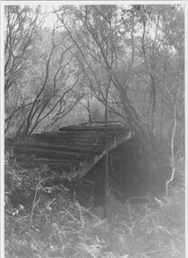
 Halls Gap & Grampians Historical Society
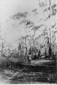
Photograph - B/W, C 1880s
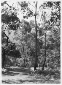
This photo is of the road approaching Delley's Bridge. It shows methods of transport and the access route to Halls Gap in the late 19th Century.A man with a walking stick walking away from the camera on a rutted dirt road through trees and bush. Another man is approaching from the opposite direction on horseback.access routes, roads -
 Halls Gap & Grampians Historical Society
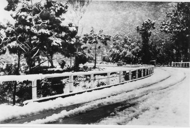
Photograph - B/W, C 1940
The third Delley's Bridge, built in 1940 with a curved deck, was situated slightly upstream from the previous bridge. Though it was subject to snow cover from time to time, raging floodwaters were not a threat after Bellfield Dam was built in the 1960s.The picture shows a curving bridge with a wood and wire railing. The bridge and surrounding trees are covered in snow.structures, bridges -
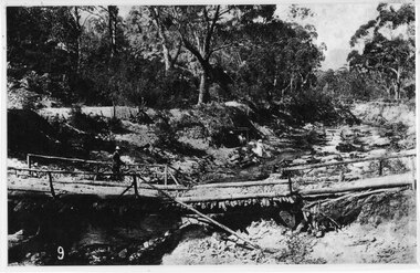
 Halls Gap & Grampians Historical Society
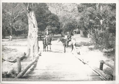
Photograph - B/W, C 1920s
The Stoney Creek dray bridge. Stoney Creek has been bridged a number of times on school road since the creek was re-routed in the early 1900s. A dray bridge was built C 1910 by local residents, which stood them in good stead for more than a decade. This bridge was replaced by a higher timber structure. Image two is a story from 1906 relating to Marshall White and his family trying to recross Delley's bridge after finding the Stoney Creek dray bridge washed away.Photo of two men on horseback on a wooden bridge with low log railing. A shelter can be seen in the background and there are thick trees surrounding the road.structures, bridges -
 Halls Gap & Grampians Historical Society
Photograph - B/W, C 1940- (before 1950)
Stoney creek has been 'bridged' a number of times in School Rd, since the creek was re-routed in the early 1900's. A dray bridge was built c1910 by local residents which stood them in good stead for more than a decade.Photo of 'school bridge' over Stoney Creek. Gravel road in foreground leading to a wooden bridge surrounded by tall gum trees.structures, bridges -
 Halls Gap & Grampians Historical Society
Photograph - B/W, C 1933
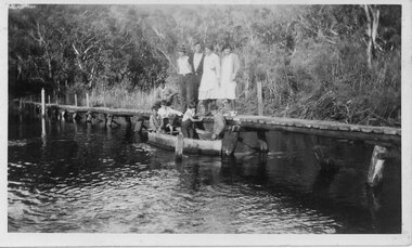
The photo shows the Wannon River in flood. Augustus (Gus) Knight built the footbridge. The boat was constructed using kerosene tins or honey tins.Photo shows five adults, four standing and one squatting, on a foot bridge. There are four children in front of them in a boat.structures, bridges -
 Halls Gap & Grampians Historical Society
Photograph - B/W, C 1933
The photo shows "Knight's Bridge" at the Wannon River Crossing.Photo shows two women, one sitting and one standing leaning on the other woman's shoulder. They are on a wooden footbridge with water in the foreground and thick bush in the background.structures, bridges -
 Halls Gap & Grampians Historical Society
Photograph - B/W, C 1970s (?)
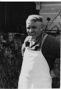
Robert Greer was the Hall's Gap baker. He married Ida Warren and they had a daughter Rae. Robert & Ida inherited the bakery from Ida's father John Warren who established the business in 1929. For further details see Bridging the Gap, p.56Photo shows man (Robert Greer) in an apron standing outside his house.people, greer, buildings, bakery -
 Halls Gap & Grampians Historical Society
Photograph - B/W, C 1950s (?)
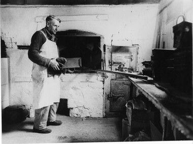
Robert Greer, baker, married Ida Warren whose family started the bakery; in 1929. Robert & Ida inherited the Bakery from Ida's father John Warren. for further information see Bridging the Gap p. 56Photo shows Robert Greer, baker standing with a load tin in his hands, inside the bakery. Baking tins & ovens can be seen in the photo.Folio no.48 Negative no.25people, greer, buildings, bakery -
 Halls Gap & Grampians Historical Society
Photograph - B/W, C 1932
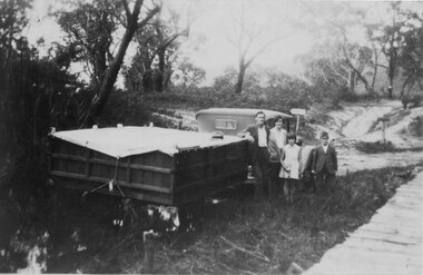
A family on holiday in the Grampians. The deep wagon is an early form of caravan, which folded down and was ready to erect when a site was found. The man is Jack Diamond from Donald.The photo shows a family (a man, a woman, a girl and a boy) standing beside an old car pulling a deep, wooden wagon covered by a tarpaulin. A mans hat sits on the tarpaulin near the man's elbow.The wagon appears to be standing in water and there is a wooden slat surfaced bridge ortrestle to the right. A track with two signposts is in front of the car and there is thin bush in the background.recreation, camping, transport, cars -
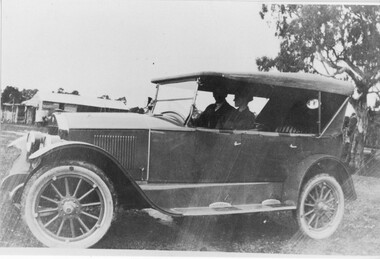 Halls Gap & Grampians Historical Society
Photograph - B/W, C 1920 (?)
The woman in the photo is Ruth Pickering from Dadswell's Bridge.The photo shows a man and a woman seated in a car (Chevrolet ?). A building can be seen in the background.peopletransport, cars -
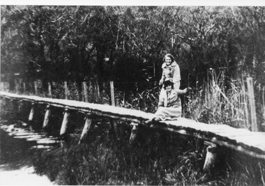 Halls Gap & Grampians Historical Society
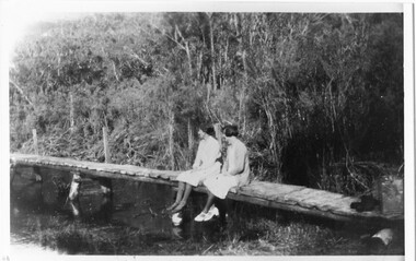
Photograph - B/W
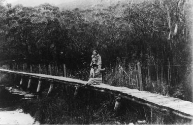
Photo of foot-bridge over the Wannon crossing. c1920-Photo shows 2 women one seated, one standing on a wooden foot-bridge; both are wearing overcoats, one is wearing a hat. The bridge has post & wire fence on one side. Bush in background is thick so too reeds & rushes.structures, bridges -
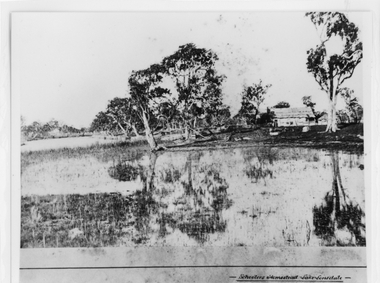 Halls Gap & Grampians Historical Society
Photograph - B/W, c 1869
Photo is said to be of Schoolers' homestead,Lake Lonsdale. Miss Scouller was the teacher at Halls Gap Primary school in 1921.Spelling of Schooler varies from that on front of photo to 'Scouller' which appears in book "Bridging the Gap'.Photo shows bark roofed building on a bank of a body of water . A number of large gum trees surround the buildings-- tree reflections can be seen in the water. There appears to be extensive fencing around the buildings. The homestead is not visible.buildings, houses -
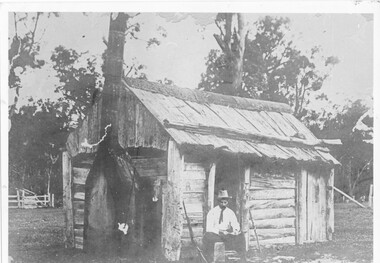 Halls Gap & Grampians Historical Society
Photograph - B/W, c 1850s
This windowless bark hut would have been used by stockmen who looked after sheep and cattle in the Fyans Valley. This hut was situated at the site later named the Borough Huts. See p8 Bridging the Gap Photo shows a man sitting outside a wooden slab hut. The hut has a tin flashing along top roof line. Man is wearing a hat and tie. A gun is leaning up against wall of hut. A sheep or cattle race can be seen in left corner of photo. buildings, houses -
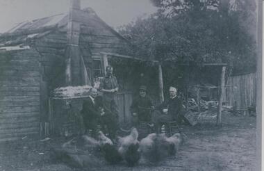 Halls Gap & Grampians Historical Society
Photograph - B/W
Fred Paasch was born in Denmark in 1862. It is unknown when he arrived in Australia or when he settled in Halls Gap. He owned land generally in the area now occupied by the Halls Gap Supermarket where he established an orchard. See " Bridging the Gap " p.58-60 "Victoria's Wonderland" p.98-99.Shingle and slab house, chimney has loose brick base and tin flue. Four men in foreground. Freddy Paasch, owner of the house is seated in the centre. A number of hens feed in the near foreground. A climbing rose coyers the fence and part of the house roof.buildings, houses, people, paasch -
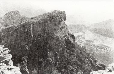 Halls Gap & Grampians Historical Society
Photograph - B/W
Relph Peak, named after A.U. Relph of the Government Tourist Department. See P67 of Bridging the Gap, by Ida Stanton. Steep rocky escarpment, valley down below, smaller range opposite, mountain rising higher in background.scenery, wonderland range -
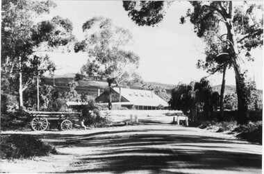
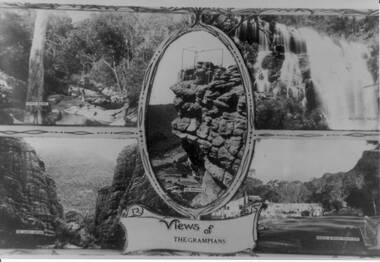 Halls Gap & Grampians Historical Society
Photograph - B/W, C 1930s
The four scenes are 1) Venus Baths [top left],2) Mackenzie Falls[top right],3) The Grand Canyon[bottom left],4)Bridge and Road at Halls Gap[bottom right]. A centre view in an oval frame is The Pinnacle and a scroll with 'Views of the Grampians' written on it appearing below the frame. A scrolled frame runs top and bottom of the four scenes.Photo is a copy of a postcard, depicting four scenes in the Wonderland Range.scenery, grampians ranges -
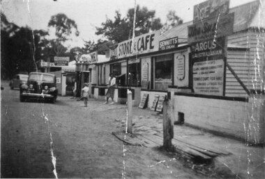 Halls Gap & Grampians Historical Society
Photograph - B/W
See 'Bridging the Gap' p65. Grampians Road Halls Gap.Group of shops with numerous advertising signs. A woman is leaving a shop, a young girl is standing in front of her. Two cars are parked in front of shops. Gravel road. Large gum trees in the background.buildings, shops -
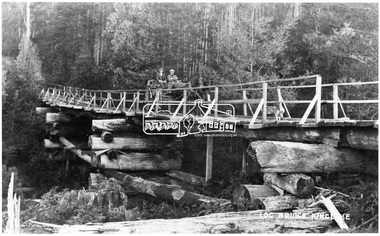 Eltham District Historical Society Inc
Negative - Photograph, Log bridge over Pheasant Creek, Kinglake, c.1920
Horse and cart with driver Mr. F. Thomson and passenger cross a wooden bridge with log tree trunk base construction supported by timber rails over Johnstone's Creek amidst the Kinglake forest. The bridge was built for the timber tramline. There was also a logging district in the Pheasant Creek area just outside the Shire of Eltham. Note dog also sitting on bridge.This photo forms part of a collection of photographs gathered by the Shire of Eltham for their centenary project book,"Pioneers and Painters: 100 years of the Shire of Eltham" by Alan Marshall (1971). The collection of over 500 images is held in partnership between Eltham District Historical Society and Yarra Plenty Regional Library (Eltham Library) and is now formally known as 'The Shire of Eltham Pioneers Photograph Collection.' It is significant in being the first community sourced collection representing the places and people of the Shire's first one hundred years.Digital image 4 x 5 inch B&W Neg 120 format B&W negative (spare) 2 x printsbridge, f. thomson, kinglake, log bridge, mr. munro, pheasant creek, pioneers and painters, shire of eltham pioneers photograph collection, timber tramway