Showing 83 items matching "walking trail"
-
 Bendigo Historical Society Inc.
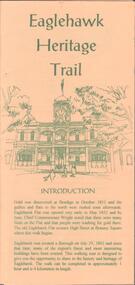
Document - EAGLEHAWK HISTORICAL SOCIETY COLLECTION: EAGLEHAWK HERITAGE TRAIL
Small brochure titled: Eaglehawk Heritage trail, after an introduction a map of the points of interests, few drawing of different buildings, in total the brochure give small information on 33 locations.eaglehawk, history, walking tour -
 Whitehorse Historical Society Inc.
Letter - Correspondence, Yarran Dheran, 17/01/1979 12:00:00 AM
... and reserves Schwerkolt Cottage Walking Trails Bicycle Paths Letter ...Letter from Yarran Dheran Committee of Management to Town Clerk, Nunawading 17/1/1979.Letter from Yarran Dheran Committee of Management to Town Clerk, Nunawading 17/1/1979 regarding walking and bicycle tracks between Schwerkolt Cottage and Yarran Dheran. With letter from Ann Creber to George Cox regarding meeting on the subject.Letter from Yarran Dheran Committee of Management to Town Clerk, Nunawading 17/1/1979.yarran dheran, parks and reserves, schwerkolt cottage, walking trails, bicycle paths -
Whitehorse Historical Society Inc.
Pamphlet, Heritage trails in Whitehorse - Blackburn, 2001
... Mitcham melbourne walking trails city of whitehorse blackburn ...Heritage Trail through Blackburn - brochure with map and historical information and photographs of places of historical interest throughout Blackburn.Heritage Trail through Blackburn - brochure with map and historical information and photographs of places of historical interest throughout Blackburn. A heritage fund project supported by the Commonwealth.Heritage Trail through Blackburn - brochure with map and historical information and photographs of places of historical interest throughout Blackburn.walking trails, city of whitehorse, blackburn -
 Whitehorse Historical Society Inc.
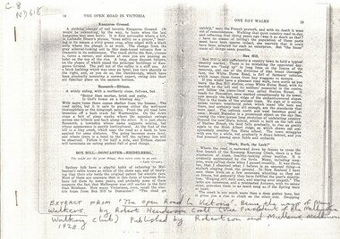
Article, The Open Road, 1928
... Mitcham melbourne vermont walking trails canterbury road box hill ...'The Open road to Victoria', by Robert Henderson Croll, Melbourne: Robertson & Mullens, 1928.Photocopied extract from 'The Open road to Victoria', by Robert Henderson Croll, Melbourne: Robertson & Mullens, 1928. pp 18 - 24 describing one day walks in the eastern suburbs.'The Open road to Victoria', by Robert Henderson Croll, Melbourne: Robertson & Mullens, 1928.vermont, walking trails, canterbury road, box hill -
Whitehorse Historical Society Inc.
Document, Walking in Whitehorse, 2003
... Mitcham melbourne Walking trails City of Whitehorse Pamphlet ...Pamphlet detailing ten walks in the municipality.Pamphlet detailing ten walks in the municipality.Pamphlet detailing ten walks in the municipality.walking trails, city of whitehorse -
Whitehorse Historical Society Inc.
Article, Historical streets, 2006
... Mitcham melbourne Surrey Hills Mont Albert Walking trails Heritage ...Heritage trails of Mont Albert and Surrey Hills completed by Whitehorse Council.Heritage trails of Mont Albert and Surrey Hills completed by Whitehorse Council.Heritage trails of Mont Albert and Surrey Hills completed by Whitehorse Council.surrey hills, mont albert, walking trails -
Whitehorse Historical Society Inc.
Document, Walking in Whitehorse, 2006
... Mitcham melbourne City of Whitehorse Walking trails Pamphlet ...Pamphlet describing walks in the City of Whitehorse [Rev. ed]Pamphlet describing walks in the City of Whitehorse [Rev. ed]Pamphlet describing walks in the City of Whitehorse [Rev. ed]city of whitehorse, walking trails -
Whitehorse Historical Society Inc.
Map, Pocket guide to walking and wheeling in Whitehorse, 2008
... Mitcham melbourne Includes walking and cycling groups. Walking ...Map showing walks, cycle tracks and off lead areas for dogs in Whitehorse.Map showing walks, cycle tracks and off lead areas for dogs in Whitehorse. Includes walking and cycling groups.Map showing walks, cycle tracks and off lead areas for dogs in Whitehorse. walking trails, bicycle paths, city of whitehorse -
Whitehorse Historical Society Inc.
Pamphlet, Walking and wheeling in Whitehorse, 2009
... Mitcham melbourne City of Whitehorse Walking trails A Guide ...A Guide to great walks in Whitehorse.A Guide to great walks in Whitehorse.A Guide to great walks in Whitehorse.city of whitehorse, walking trails -
 Whitehorse Historical Society Inc.
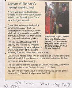
Article, Indigenous Art Trail, Sep 2023
... Shed A new walking trail has been created near Schwerkolt ...A new walking trail has been created near Schwerkolt Cottage featuring indigenous art.non-fictionA new walking trail has been created near Schwerkolt Cottage featuring indigenous art.eastlink indigenous art trail, eastlink trail, mullum mullum creek, croydon hills men's shed -
 Whitehorse Historical Society Inc.
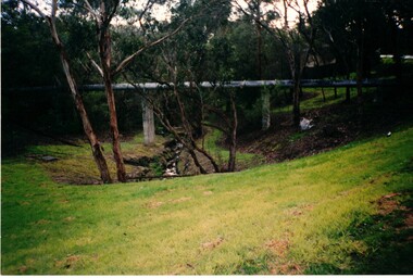
Photograph, Deep Creek Walking Trails, 28/11/1984 12:00:00 AM
... Mitcham melbourne Walking Trails Deep Creek Four coloured ...Four coloured photographs of various views along walking track near Deep Creek Mitchamwalking trails, deep creek -
 Kew Historical Society Inc
Photograph - Grampians, 1924
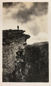
Henry Beater Christian (1886-1962) , was a descendant of one of the earliest settler families in Kew. Employed at the Kew Asylum as a 'public servant', he was a skilled amateur photographer, photographing numerous scenes in Kew and on his travels around Victoria. The majority of his photographs date from 1916 to 1929. His finest photographs are housed in two photograph albums. Digital copy of a photograph from page 12 of the 47-page photograph album containing 261 gelatinous silver images, loaned by Diane Washfold with permission given to digitise and hold a copy in our collection. The first and last pages in the album document the Yarra River at Studley Park and at Kew. The remainder of the album includes photographs of walking and car tours in rural Victoria including 'wilderness' areas in the Grampians, Gippsland and the High Country. Six album pages document a camping trip by Henry Christian to the Grampians in September 1924. The photos include pictures of lookouts, and natural features including rock faces and waterfalls, as well as his camp site. This photo is of a man, perhaps Henry Christian, standing on one of the lookouts on what is probably the Mt Victory trail. "Mt Victory / Grampians / 9.24"henry beater christian (1886-1962), landscape photography, christian-washfold collection, photograph albums, grampians, mt victory, gariwerd -
 Kew Historical Society Inc
Photograph - Grampians, 1924
Henry Beater Christian (1886-1962) , was a descendant of one of the earliest settler families in Kew. Employed at the Kew Asylum as a 'public servant', he was a skilled amateur photographer, photographing numerous scenes in Kew and on his travels around Victoria. The majority of his photographs date from 1916 to 1929. His finest photographs are housed in two photograph albums. Digital copy of a photograph from page 12 of the 47-page photograph album containing 261 gelatinous silver images, loaned by Diane Washfold with permission given to digitise and hold a copy in our collection. The first and last pages in the album document the Yarra River at Studley Park and at Kew. The remainder of the album includes photographs of walking and car tours in rural Victoria including 'wilderness' areas in the Grampians, Gippsland and the High Country. Six album pages document a camping trip by Henry Christian to the Grampians in September 1924. The photos include pictures of lookouts, and natural features including rock faces and waterfalls, as well as his camp site. This photo is of a man, perhaps Henry Christian, holding his camera while standing on one of the lookouts on what is probably the Mt Victory trail. The photo was framed in a circle during the development process. "Mt Victory / Grampians / 9.24"henry beater christian (1886-1962), landscape photography, christian-washfold collection, photograph albums, grampians, mt victory, gariwerd -
 Kew Historical Society Inc
Photograph - Grampians, 1924
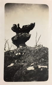
Henry Beater Christian (1886-1962) , was a descendant of one of the earliest settler families in Kew. Employed at the Kew Asylum as a 'public servant', he was a skilled amateur photographer, photographing numerous scenes in Kew and on his travels around Victoria. The majority of his photographs date from 1916 to 1929. His finest photographs are housed in two photograph albums. Digital copy of a photograph from page 12 of the 47-page photograph album containing 261 gelatinous silver images, loaned by Diane Washfold with permission given to digitise and hold a copy in our collection. The first and last pages in the album document the Yarra River at Studley Park and at Kew. The remainder of the album includes photographs of walking and car tours in rural Victoria including 'wilderness' areas in the Grampians, Gippsland and the High Country. Six album pages document a camping trip by Henry Christian to the Grampians in September 1924. The photos include pictures of lookouts, and natural features including rock faces and waterfalls, as well as his camp site. This photo is of a self-standing rock on what is probably the Mt Victory trail. "Mt Victory / Grampians / 9.24"henry beater christian (1886-1962), landscape photography, christian-washfold collection, photograph albums, grampians, mt victory, gariwerd -
 Surrey Hills Historical Society Collection
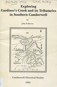
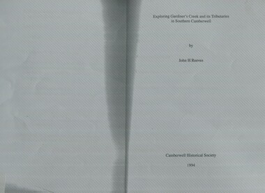
Book, Exploring Gardiner's Creek and its tributaries in southern Camberwell, 1994
... ashburton creek delaney's creek walking trails rivers creeks glass ...This book describes geographical landmarks, in particular the waterways, that make up the City of Camberwell (now City of Boroondara).This book describes geographical landmarks, in particular the waterways, that make up the City of Camberwell (now City of Boroondara).gardiner's creek, (mr) john gardiner, koonung creek, back creek, glass's creek, w creek, west creek, ashburton creek, delaney's creek, walking trails, rivers, creeks, glass creek -
 Surrey Hills Historical Society Collection
Book, Exploring Gardiner's Creek and its tributaries in southern Camberwell, 1994
... ashburton creek delaney's creek walking trails rivers This book ...This book describes geographical landmarks and especially waterways that of the City of Camberwell (now City of Boroondara).This book describes geographical landmarks and especially waterways that of the City of Camberwell (now City of Boroondara).gardiner's creek, (mr) john gardiner, koonung creek, back creek, glass's creek, w creek, west creek, ashburton creek, delaney's creek, walking trails, rivers -
Tatura Irrigation & Wartime Camps Museum
Painting - Painting, Oil, Centaur, 1945
Harry Gorry bid for & purchased on internet auction site. The seller's mother was putting these & other items up for auction. Her father, the seller's grandfather was Dr. Bruno Koenig, a German surgeon detained by Allied forces while fleeing New Guinea in 1941. He was detained & sent to be interned in Camp 3, Tatura. There he met the painter Cesare Vagarini & they became friends, thus 4 years later upon the end of the war Vagarini gave the surgeon the two paintings in thanks & in memory of their friendship. Dr Koening then passed the paintings down to his daughter, where they remained in the family for 60 years. The seller's mother decided it was time to sell & was happy that the paintings went to a good home, as the family was until now unaware of the connection between Vagarini and the Tatura Museum. Harry Gorry just happened to notice a familiar name in an auction that he came across by accident & purchased them for our benefit. (Most information copied from Tatura Bulletin article, April 2014).Oil painting, depicting mythological scene. Female figure (unclothed), holding a red cloth/ garment trailing behind her. Centaur / faun? walking beside her. Outdoor scene. Trees, mountains & cloudy blue sky visible in background. Sandy coloured soil. Painted on reverse of old "Choice Tea" box.(On back): 1945 Tatura; ... remember ..... and us, Cesare and Maria Vagarini; On back, on sticker: Va(r)garini, Tatura Internment Camp, 1945 "Choice Tea" stencilled on back, part of original box material.tatura, camp 3, cesare vagarini, camp 3 artwork, victorian internment camps, doctor bruno koenig -
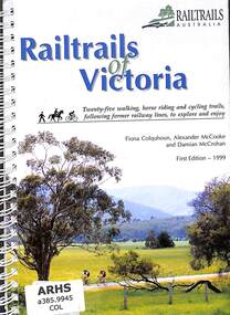 Victorian Railway History Library
Book, Colquhoun, Fiona et al, Railtrails of Victoria, 1999
A listing of rail trails in Victoria with details and maps.ill, maps. p.120.non-fictionA listing of rail trails in Victoria with details and maps.railtrails - victoria, walking - victoria - guides -
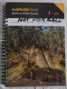 Buninyong Visitor Information Centre
Book, Gib Wettenhall, Goldfields Track: Walk or Ride Guide. 2nd Edition, 12.2017
... to Buninyong. Great Dividing Trail Goldfields Cycling Walking Tracks ...The guide was written by Gib Wettenhall in collaboration with the Great Dividing Trail Association and Goldfields Tracks Inc. The book gives detailed information about the track including historical notes, maps and numerous photographs. Members of the Buninyong Visitor Centre and the local community actively supported the extension of the Great Dividing Trail from Ballarat through to Buninyong. Spiral bound book with photograph on cover showing mining works and tourists visiting. Title is on a black section. 'Not for Sale' handwritten in Texta on the cover.great dividing trail, goldfields, cycling, walking, tracks -
 Eltham District Historical Society Inc
Photograph - Digital Photograph, Alan King, Sign: Clara Southern, Heidelberg School Artists Trail, Main Road, Research, 2008
Warrandyte artist, Clara Southern, features on the Artists Trail. Published: Nillumbik Now and Then / Marguerite Marshall 2008; photographs Alan King with Marguerite Marshall.; p189 Since early in the 20th century this district has attracted artists and other creative people. So much so, that Eltham has been compared to the Left Bank in Paris, New York’s Greenwich Village and London’s Bloomsbury. That is until the 1970s when Eltham rapidly expanded into a suburb. However many artists still flourish not only in Montsalvat, Dunmoochin and the Bend of Islands but elsewhere in Nillumbik. Some artists who have worked or lived in Nillumbik are well-known nationally and internationally. Artists are attracted to the hilly district’s subtle colours, unique light and the Yarra River and Diamond Creek. The railway’s extension to Eltham in 1902 brought artists to paint for the day or to camp. Then many settled in Eltham, perhaps also because the poor quality land, far from the city, was cheap. Following World War Two they found they could build houses and studios cheaply by making their own mud-bricks. The flexible material, with its warm tones blending into the bush, also satisfied their aesthetic sensibilities. As early as 1900, Will Longstaff, known for his painting The Ghosts of Menin Gate at the National War Memorial in Canberra, lived at Stanhope in Peter Street, Eltham, later to become the home of intellectuals Clem and Nina Christensen. Members of Australia’s first significant art movement, the Heidelberg School of Artists, painted in Eltham, Warrandyte and Diamond Creek. Walter Withers lived at the corner of Bolton and Brougham Street, Eltham and taught Sir Hans Heysen, who for a short while stayed with the Withers family. In Warrandyte were Clara Southern, whom Frederick McCubbin taught at the National Gallery School and Penleigh Boyd, who is represented in all Australian state galleries and the National Collection in Canberra. May Vale, daughter of politician William, lived in Diamond Creek. With Jane Price they feature on the Heidelberg School Artists Trail, part of which runs through Nillumbik. The trail includes signs each displaying a reproduction of a painting by an artist and located near where the artist lived or painted. In Nillumbik the trail includes parts of Warrandyte, Eltham in the Alistair Knox Park, Main Road shopping precinct and Wingrove Park, the Research walking track on Main Road and the Diamond Creek Reserve. In 1916 artist William ‘Jock’ Frater lived at the corner of Arthur and Bible Streets, Eltham. Before then, Frater, with other artists including Percy Leason (who moved to Eltham in the mid 1920s) painted in Eltham on weekends. They camped near Bible and Pitt Streets and along the Diamond Creek where the Eltham Retirement Centre now stands.4 In 1921, painter Peter Newbury (father to painter David Newbury, who was born in Eltham) moved to Cromwell Street, Eltham. Max Meldrum, the first Australian painter to formulate a consistent theory of art largely based on tone,5 taught local artists Alan Martin, Clarice Beckett, Peter Glass and Justus Jörgensen. Meldrum visited Eltham then rented a house there for 18 months opposite Wingrove Park. In 1934, artist and architect Justus Jörgensen and his doctor wife Lil and friends built Montsalvat, the artists’ colony. Montsalvat has played an important part in attracting artists to Eltham and its mud-brick, pisé, stone and recycled building materials has had a major influence on Eltham’s built environment. Jörgensen’s students who also helped him build Monstalvat included Arthur Munday, Lesley Sinclair, Helen Lempriere, Joe Hannan, Helen, Sonia and jeweller/sculptor, Matcham Skipper. Among artists who visited Montsalvat were Clifton Pugh and Angry Penguins’ artists Albert Tucker and Arthur Boyd. Some who painted after World War Two were Alan Martin of Eltham and Warrandyte artists Frank Crozier and Harry De Hartog6, one of Melbourne’s first painters influenced by Cubism.This collection of almost 130 photos about places and people within the Shire of Nillumbik, an urban and rural municipality in Melbourne's north, contributes to an understanding of the history of the Shire. Published in 2008 immediately prior to the Black Saturday bushfires of February 7, 2009, it documents sites that were impacted, and in some cases destroyed by the fires. It includes photographs taken especially for the publication, creating a unique time capsule representing the Shire in the early 21st century. It remains the most recent comprehenesive publication devoted to the Shire's history connecting local residents to the past. nillumbik now and then (marshall-king) collection, clara southern, main road, research (vic), heidelberg school artists trail -
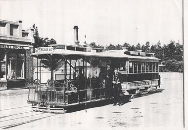 Melbourne Tram Museum
Document - Photocopy, cable car set at the Victoria St terminus, c1900
Photograph of a cable car set at the Victoria St terminus, with a conductor, Gripman and Inspector standing for the photograph. The terminus refreshment rooms are on the left hand side. The second image has a wider view, of a lady and a young child walking to the trailer and some ladies in the doorway of the Refreshment rooms. This photograph has been published.Yields information about the Victoria Bridge cable tram terminus.Black and white photograph photocopy onto an A4 sheet - two copies held.On rear of copy 2 in ink "Melbourne Cable trams, photo taken at Victoria Bridge or Studley Park showing trail car No. 81. Has the CRG Field stamp and number 682 ABX in pencil and the number "173" in top right hand corner.trams, tramways, victoria st, cable trams -
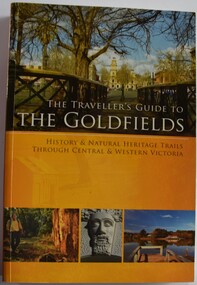 Buninyong Visitor Information Centre
Book, The Traveller's Guide to the Goldfields. History and Natural Heritage Trails Through Central and Western Victoria
... to walking trails and towns in Central and Western Victoria Old ...Guidebook to walking trails and towns in Central and Western VictoriaPerfect bound paperback with coloured cover with illustrations of scenes around Western Vicoria.non-fictionGuidebook to walking trails and towns in Central and Western Victoriagoldfields victoria -
Glen Eira Historical Society
Letter - Rosstown Railway
... Walking Trails Ross William Murray Transport Objects Locomotion ...This file contains four items: 1/A black and white photocopy of a letter dated either 07/08/1889 or 09/08/1889, from Robert Lundon to an unidentified recipient discussing an agreement reached between the author – on behalf of the recipient – and Soon Hang Hi in regard, in regards to the allotment known as Webber’s. The agreement is outlined in the letter in what appears to be Chinese characters, and includes the marks of Robert Lundon and Soon Hang Hi. File note from Joy Wu states that the calligraphy is not Mandarin or traditional Chinese. 2/Three sheets of hand-written working notes with information taken from the Victorian Government Gazette on THE ROSSTOWN AND MURRUMBEENA LAND COMPANY LIMITED, THE ROSSTOWN JUNCTION RAILWAY AND PROSPERITY COMPANY LIOMITED, and THE ROSSTOWN JUNCTION, ELSTERNWICK, AND OAKLEIGH RAILWAY COMPANY LIMITED, covering dates between 1887 and 1894. The notes concern meetings and creditors claims relevant to the companies, with reference numbers for the information source. Date and author of the notes are not recorded. 3/A black and white photocopy of the a partial map of the Rosstown Railway and surrounding area, undated. The map includes the names of landholders in the areas of Brighton, Garden Vale and Elsternwick, as well as other railway lines present in the region. 4/A fold-out map and guide of the Rosstown Rail Trail, including a brief general history of Caulfield as well as a more extensive biography of William Murray Ross and the Rosstown Railway. The map marks and describes significant sites along the trail, including photographs of some of these sites, provided by DF Jowett.documents, correspondence, webber’s, lundon robert, chinese characters, ethnic communities, signatures, text, settlements, taxes, fraser john grieves, lovell r.h., price davies, meetings, communication activities, soon hang hi, commercial events and activities, the rosstown and murrumbeena land company limited, victorian government gazette, bulmer richard, parry john, osment henry, shareholders, creditors claims, the rosstown junction railway and property company limited, finch and best, lawyers, the rosstown junction elsternwick and oakleigh railway company limited, cameron w.c., phillips p.d., garden vale, elsternwick, elsternwick railway station, rosstown, rosstown railway, thomas street, bay street, kooyong road, melbourne and brighton railway, hawthorn road, bambra road, caulfield and frankston railway, booran road, grange road, koornang road, murrumbeena road, north road, north road railway station, east brighton railway station, south road, railway routes, railway lines, railways, land transport, murphy j., caulfield, hamilton t.f., dane p., holloway, webb, ailee john, payne t.b., brodie chas, dane john, o’neil h., mccombie john, mcmillane a., smyth c.d., cooper, ebden, landholders, jeffrey j.d., gill j., balcombe a.e., cooper h., mcnab j., white j., sutherland j., greeves a.f.a., newton m.c., chamley f.b., fowler j., inglis p., grant t., stooke j., swanson g., cochrane c., adams e.b., mccombie thas, keyes robert, brighton cemetery, burials grounds and graveyards, war-ein road, were j.b., holland j., mcmahon c., winter t.l.m., dendy henry, mitchell w., jackson s., were j.e., wickham francis dawe, bryant jane, east brighton railway station, railway stations, maps, allotments, land titles, roads and streets, rosstown rail trail, city of glen eira, tourism, trains, tourism information bureaus, tours, pamphlets, elsternwick railway park, oakleigh junction, princes park, ee gunn reserve, packer park, sites, jowett d.f., weickhardt i.g., return to rosstown: railways land sales and sugar beet ventures in caulfield, land sales, walking trails, ross william murray, transport objects, locomotion, walking, cycling, driving, sports, country mansions, people, caulfield john, builders, construction and demolition workers, occupations, careers, professionals, topography, geology, landforms, horticulture, market gardens, primary industry workers, city of caulfield, mood kee, pennington harold, annual general meetings, caulfield town hall, glen eira city council, carnegie, carnegie station, rosstown station, people by circumstance, migrants, sugar beet, sugar beet mill, sugar beet industry, mills, factories, sea beach lines, bent thomas, parliamentary representatives, neville street, miller street, lemann’s swamp reserve, koornang park, cane sugar industry, breweries, rabbit processing plants, health establishments, hospitals, food production establishments, abattoirs, thieves, social problems, vagrants, theft, squatting, financial economics, debt, finance industry, insurance companies, company managers, bentleigh, ross leila, the grange, leila road, wild cherry road, financial trouble, mortgages, gisborne street, archibald street, riddell parade, victoria railways, glen huntly road, clarence street, college street, gladstone parade, parrell street, aileen avenue, seaview street, land subdivisions, dover street, sussex street, landfill, marara road, booran road, woodville avenue, dorothy avenue, ormond park, royal avenue, ormond railway station, oakleigh road, melten avenue, miller street, munro avenue, lord reserve, neerim road, toolambool road, the rosstown hotel, rosanna street, murrumbeena crescent, commercial establishments, the national bank, rosstown road, kangaroo road, poath road, freda street, hughesdale kindergarten, oakleigh council, hughesdale community centre, civic establishments, galbally reserve, plaques, warrigal road, out and about brochures, orion estate