Showing 315 items
matching walking victoria
-
 Marysville & District Historical Society
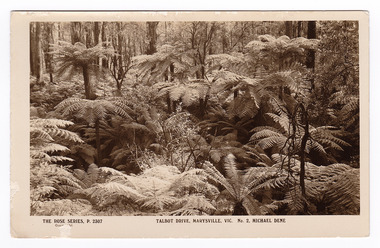
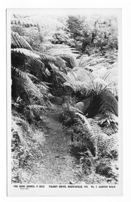
Postcard (item) - Black and white postcard, Rose Stereograph Company, Talbot Drive, Marysville, Vic. No. 2, Michael Dene, 1913-1967
A postcard in a series produced by the Rose Stereograph Company in Victoria, Australia as a souvenir of Marysville.A black and white photograph showing trees and tree ferns, taken along the Michaeldene Trail near Lady Talbot Drive in Marysville in Victoria. The Michaeldene Trail is a level two loop that leads to the Taggerty River Lookout and may be undertaken as either as a Short (2.7 km) Loop, or a Long (4.3 km) Loop - 30 minutes to one hour and a half. The attractive bushland linking the Steavenson and Taggerty Rivers allows walkers and cyclists to step back in time to Marysville’s historic logging past. Sections of this mostly flat circuit follow old tramline alignments, which in places reveal the original timber sleepers on which the big logs were transported to the nearby sawmill.The Taggerty River Lookout offers views over the Taggerty River. The Trestle Bridge was built to span a small gully and provide access to the timber on Red Hill. Lady Talbot Drive is a 24 kilometer scenic rainforest car journey which passes a number of walks and waterfalls in the Yarra Ranges National Park. Lady Talbot Drive is named after Lady Sarah Elizabeth, the wife of Sir Reginald Talbot, who was the Governor of Victoria from 25th April, 1904 to 6th July 1908. This postcard was produced by the Rose Stereograph Company as a souvenir of Marysville.REAL PHOTO POST CARD THE "ROSE"SERIES DE LUXE PRODUCED IN AUSTRALIA Published by "The Rose Stereographs" Armadale, Victoria.marysville, victoria, michael dene, michael dene track, p. 2307, walking track, rose series postcard, postcard, souvenir, lady talbot drive, sarah elizabeth talbot, sir reginald talbot -
 Marysville & District Historical Society
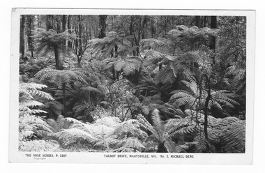
Postcard (item) - Black and white postcard, Rose Stereograph Company, Talbot Drive, Marysville, Vic. No. 2, Michael Dene, 1913-1967
A postcard in a series produced by the Rose Stereograph Company in Victoria, Australia as a souvenir of Marysville.A black and white photograph showing trees and tree ferns, taken along the Michaeldene Trail near Lady Talbot Drive in Marysville in Victoria. The Michaeldene Trail is a level two loop that leads to the Taggerty River Lookout and may be undertaken as either as a Short (2.7 km) Loop, or a Long (4.3 km) Loop - 30 minutes to one hour and a half. The attractive bushland linking the Steavenson and Taggerty Rivers allows walkers and cyclists to step back in time to Marysville’s historic logging past. Sections of this mostly flat circuit follow old tramline alignments, which in places reveal the original timber sleepers on which the big logs were transported to the nearby sawmill.The Taggerty River Lookout offers views over the Taggerty River. The Trestle Bridge was built to span a small gully and provide access to the timber on Red Hill. Lady Talbot Drive is a 24 kilometer scenic rainforest car journey which passes a number of walks and waterfalls in the Yarra Ranges National Park. Lady Talbot Drive is named after Lady Sarah Elizabeth, the wife of Sir Reginald Talbot, who was the Governor of Victoria from 25th April, 1904 to 6th July 1908.REAL PHOTO POST CARD THE "ROSE"SERIES DE LUXE PRODUCED IN AUSTRALIA Published by the Rose Stereographs Armadale, Victoria. Tomorrow is your Official day/ I believe. So Very Very many happy/ returns, & best of luck & good/ wishes from/ your May I rec'd this on/ 1st. (illegible)/ thought it a good snap of our ferns.marysville, victoria, michael dene, michael dene track, p. 2307, walking track, rose series postcard, postcard, souvenir, lady talbot drive, sarah elizabeth talbot, sir reginald talbot -
 Marysville & District Historical Society
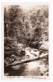
Postcard (item) - Black and white postcard, Rose Stereograph Company, Talbot Drive, Marysville, Vic. No. 3, The Taggerty River, 1913-1967
A postcard in a series produced by the Rose Stereograph Company in Victoria, Australia as a souvenir of Marysville.A black and white photograph taken along Lady Talbot Drive, Marysville, in Victoria, of the Taggerty River. Lady Talbot Drive is a 24 kilometer scenic rainforest car journey which passes a number of walks and waterfalls in the Yarra Ranges National Park. Lady Talbot Drive is named after Lady Sarah Elizabeth, the wife of Sir Reginald Talbot, who was the Governor of Victoria from 25th April, 1904 to 6th July 1908. This postcard was produced by the Rose Stereograph Company as a souvenir of Marysville.POST CARD The "Rose " Series/ De Luxe A Real Photograph/ Produced in Australia Published by the Rose Stereograph Co./ Armadale, Victoria. Dear John,/ I am writing this note in my room/ at Mt. Kitchener House before sallying forth for/ dinner. Unfortunately space does not permit/ me to tell you much, but I must let you know/ that yesterday morning (Monday), a blanket of/ snow covered the township of Marysville to a/ depth of three or four inches. Further up, near/ Keppel's Lookout, which we visited yesterday, it/ was nearly a foot deep everywhere, and it snowed/ the whole time we were walking./ Will tell you all later, your friend, Billtalbot drive, marysville, victoria, taggerty river, p. 2308, rose series postcard, postcard, souvenir, sir reginald talbot, lady sarah elizabeth talbot -
 Marysville & District Historical Society
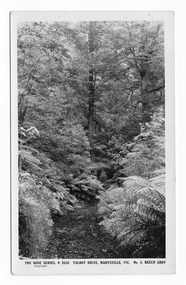
Postcard (item) - Black and white postcard, Rose Stereograph Company, Talbot Drive, Marysville, Vic. No. 5, Beech Grov, 1913-1967
A postcard in a series produced by the Rose Stereograph Company in Victoria, Australia as a souvenir of Marysville.A black and white photograph taken along Lady Talbot Drive, Marysville, Victoria, of the area known as the Beech Grove. The Beeches Rainforest Walk is a loop that starts at Taggerty Cascades before winding through Myrtle Beech and Mountain Ash woodland and is one of the many walking tracks in and around Marysville. It is accessible from Lady Talbot Drive which is a 24 kilometer scenic rainforest car journey which passes a number of walks and waterfalls in the Yarra Ranges National Park. Lady Talbot Drive is named after Lady Sarah Elizabeth, the wife of Sir Reginald Talbot, who was the Governor of Victoria from 25th April, 1904 to 6th July 1908. This postcard was produced by the Rose Stereograph Company as a souvenir of Marysville.POST CARD The "Rose" Series/De Luxe A Real Photograph/ Produced in Australia Published by the Rose Stereograph Co./ Armadale, Victoria. MATHESONtalbot drive, marysville, victoria, beech grove, p. 2310, rose series postcard, postcard, souvenir, beeches rainforest walk, sarah elizabeth talbot, sir reginald talbot, mountain ash, myrtle beech -
 Marysville & District Historical Society
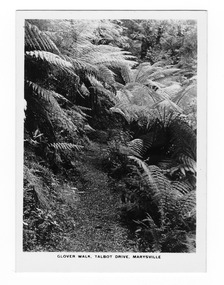
Postcard (item) - Black and white postcard, Rose Stereograph Company, Talbot Drive, Marysville, Vic. No. 7, Glover Walk, 1913-1967
A postcard in a series produced by the Rose Stereograph Company in Victoria, Australia as a souvenir of Marysville.An early black and white photograph of Glover Walk which was off Lady Talbot Drive in Marysville, Victoria. Glover Walk was named after Hannah Elizabeth Glover, a nurse who in 1908 established the Kerami guest house in Marysville. She became an active member of the local tourist association and was acclaimed for her 'energy and enterprise' (Riverine Herald, 31 December 1915). In this capacity she successfully lobbied government to fund walking tracks in the district, one of which was given her name. This postcard was produced by the Rose Stereograph Company as a souvenir of Marysville.POST CARD The "Rose" Series/ De Luxe A Real Photograph/ Produced in Australia Published by the Rose Stereograph Co.,/ Armadale, Victoria.marysville, victoria, photograph, glover walk, hannah elizabeth glover, lady talbot drive, talbot drive, p. 2312, rose stereograph company, souvenir, rose series postcard, marysville tourist association, kerami guest house -
 Marysville & District Historical Society
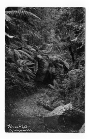
Postcard (item) - Black and white postcard, Glover Walk Marysville, Unknown
An early black and white photograph of Glover Walk which was off Lady Talbot Drive in Marysville, Victoria.An early black and white photograph of Glover Walk which was off Lady Talbot Drive in Marysville, Victoria. Glover Walk was named after Hannah Elizabeth Glover, a nurse who in 1908 established the Kerami guest house in Marysville. She became an active member of the local tourist association and was acclaimed for her 'energy and enterprise' (Riverine Herald, 31 December 1915). In this capacity she successfully lobbied government to fund walking tracks in the district, one of which was given her name.POST CARD PLACE/ POSTAGE/ STAMP/ HERE Marysville/ Dear Kath/ We managed to get here safely/ after a lovely trip, but it/ has done nothing but rain/ since we arrived. It looks/ as if it is going to clear up/ a bit & perhaps we will/ be able to get a few fish. Being over in this spot I/ am unable to send you/ the weekly suply of ??????/ so please sweetheart let me/ off this time. I hope to/ see you all again soon./ Love + kisses from your Valmarysville, victoria, glover walk, hannah elizabeth glover, lady talbot drive, talbot drive, souvenir, marysville tourist association, kerami guest house, postcard -
 Marysville & District Historical Society
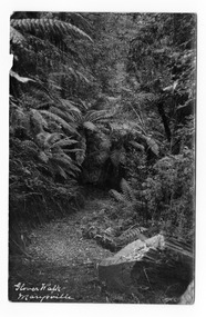
Postcard (item) - Black and white postcard, Glover Walk Marysville, Unknown
An early black and white photograph of Glover Walk which was off Lady Talbot Drive in Marysville, Victoria.An early black and white photograph of Glover Walk which was off Lady Talbot Drive in Marysville, Victoria. Glover Walk was named after Hannah Elizabeth Glover, a nurse who in 1908 established the Kerami guest house in Marysville. She became an active member of the local tourist association and was acclaimed for her 'energy and enterprise' (Riverine Herald, 31 December 1915). In this capacity she successfully lobbied government to fund walking tracks in the district, one of which was given her name.POST CARD PLACE/ POSTAGE/ STAMP/ HERE Marysville/ Jan 29th/18 Dear Lillie/ We arrived here safely on Sat after a very hot/ drive, we rested at several places on the way. The/ road is very heavy, the scenery is extremely/ beautiful, it repay one to see the beauty./ I have never seen such scenery. Weather/ today is very oppressive, it has rained all/ this morning. We leave for home tomorrow Wed./ I hope you are having a very enjoyable time/ Love from ??? Jerome ???? Sonya + Mothermarysville, victoria, glover walk, hannah elizabeth glover, lady talbot drive, talbot drive, souvenir, marysville tourist association, kerami guest house, postcard -
 Marysville & District Historical Society
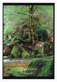
Postcard (item) - Colour postcard, Donovan Wilson, 'The Beeches' Marysville, Pre 2009
A colour photograph taken at 'The Beeches' near Marysville in Victoria.A colour photograph taken at 'The Beeches' near Marysville in Victoria. Starting from the spectacular Taggerty Cascades, the Beeches Rainforest Walk meanders through the ancient cool temperate rainforest of the Yarra Ranges. Dominated by Myrtle Beech trees and stands of Mountain Ash, the rainforest is home to many species of birds including lyrebirds.Myrtle Beech/ Nothofagus Cunninghamii/ The Beeches/ Marysville Place/ Stamp/ Here Donovan Wilson/ Photographythe beeches, marysville, victoria, postcard, souvenir, donovan wilson, walking track -
 Marysville & District Historical Society
Photograph (item) - Black and white photograph, Rose Stereograph Company, Glover Walk, Talbot Drive, Marysville, 1913-1967
An early black and white photograph of Glover Walk which was off Lady Talbot Drive in Marysville, Victoria.An early black and white photograph of Glover Walk which was off Lady Talbot Drive in Marysville, Victoria. Glover Walk was named after Hannah Elizabeth Glover, a nurse who in 1908 established the Kerami guest house in Marysville. She became an active member of the local tourist association and was acclaimed for her 'energy and enterprise' (Riverine Herald, 31 December 1915). In this capacity she successfully lobbied government to fund walking tracks in the district, one of which was given her name. The photograph was also used to produce the Rose Series postcard P. 2312.marysville, victoria, photograph, glover walk, hannah elizabeth glover, lady talbot drive, talbot drive, p. 2312, rose stereograph company, souvenir, rose series postcard, marysville tourist association, kerami guest house -
 Marysville & District Historical Society
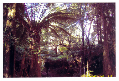
Photograph (item) - Colour photograph, 15-05-2008
... in Victoria. A colour photograph of the walking track that leads ...A colour photograph of the walking track that leads to Keppel Falls near Marysville in Victoria.A colour photograph of the walking track that leads to Keppel Falls near Marysville in Victoria. Keppel Falls are named after the Keppel Family who were one of Marysville's earliest pioneering families.2008 05 15keppel falls, marysville, victoria, waterfalls, walking track, keppel family -
 Marysville & District Historical Society
Flyer (item) - Information Flyer, Artworkz Tourism, Marysville-Historic Timber Tramway Trestle Bridge, Post 2009
... is along the Michaeldene Walking Track near Marysville in Victoria ...A flyer that was produced as a guide to the historic timber tramway trestle bridge near Marysville in Victoria.A flyer that was produced as a guide to the historic timber tramway trestle bridge near Marysville in Victoria. The historic timber tramway trestle bridge is along the Michaeldene Walking Track near Marysville in Victoria. The Michaeldene Trail to Taggerty River Lookout is a 4.3 kilometer lightly trafficked loop trail located near Marysville, Victoria. The track is one of several walking tracks located in and around Marysville in Victoria.timber tramway trestle bridge, marysville, victoria, michaeldene walking track, taggerty river, taggerty river lookout -
 Marysville & District Historical Society
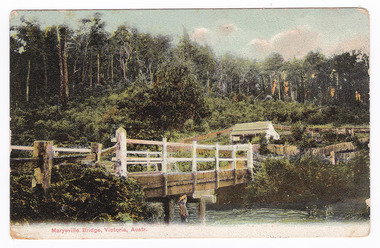
Postcard (Item) - Colour tinted postcard, Nicholas John Caire, Marysville Bridge, Victoria, Austr, 1878-1904
One of a series of postcards of photographs taken by socialite photographer Nicholas John Caire.One of a series of postcards of photographs taken by socialite photographer Nicholas John Caire. N.J. Caire had a great love for the area in and surrounding Marysville and in the late 1800's took many photographs of Marysville and its surrounds. N.J. Caire was born in 1837 in Guernsey. He arrived in Adelaide about 1860 along with his parents who encouraged his early interest in photography. He opened a studio in Adelaide in 1867 after traveling extensively throughout the Gippsland taking photographs. After marrying in 1870 he moved to Talbot in Victoria until 1876 when he opened a studio in the Royal Arcade in Melbourne. After 1885 N.J. Caire gave up his city work and made his home in South Yarra and devoted the rest of his life to outdoor photography, specializing in the bush, the gullies and the mountains of south-eastern Victoria.POST CARD This Space may be Used/ for Correspondence The Address Only to be/ Written Here. 88421 Dear Miss McNair./ We arrived home/ quite safely on Sat./ The children met/ us with Fran and/ Auntie Ethel at the/ Circular Quay. All/ were well and real/ glad to have us home/ again. We were so sorry/ we were too late/ for the train. We thought/ we saw Mr Mr McNair walking from/ the train. Love to ????/ Kisses for Ollie from A.M.G. Miss McNair/ Wattle Street/ Bendigo/ Victoriamarysville, victoria, nicholas john caire, bridge scene, 88421, postcard, souvenir -
 Marysville & District Historical Society
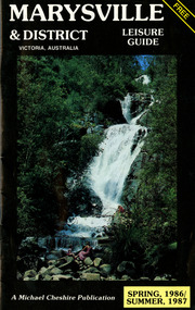
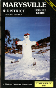
Booklet (Item) - Leisure guide, Michael Chesire & Associates Pty. Ltd, MARYSVILLE & DISTRICT LEISURE GUIDE-SPRING, 1986/SUMMBER, 1987, 1986
A free leisure guide to Marysville and the surrounding district published for Spring 1986, and Summer, 1987. This was produced by Michael Cheshire as a free publication to promote tourism in Marysville and the surrounding district. It includes maps of the Big River Valley, Cumberland Valley, Lady Talbot Forest Drive, the Marysville area, and the township of Marysville. It was released in the spring of 1986. A free leisure guide to Marysville and the surrounding district published for Spring 1986, and Summer 1987.Kilmore Historical Society *10/183 *MDL.1.marysville, victoria, australia, leisure guide, michael cheshire & associates pty ltd, marysville golf club, blackwood lodges, sir colin mackenzie fauna park, lake eildon, fraser national park, yarra valley wineries, marysville coach tours, kooringa, marylands guest house, lady talbot forest drive, wishing well, taggerty river recreation area, athols abbey, phantom falls, keppel falls, the beeches walking track, marylyn guest house, kufstein inn motel, the cumberland, marysville tourist & progress association, marysville newsagency & general store, crossways restaurant & motel, beauty spot walk, tree fern gully walk, michaeldene track, keppel track, woods lookout track, marysville hotel motel, lake mountain ski hire, marysville recreation and fun park, mytanta horseback safaris, upper big river valley, the big culvert, marysville mountain view horse hire, maryton park, amber view holiday lodges, cathedral restaurant, the top shop, tower motel, menzes garage, beauty spot nursery, marysville ski hire, lake mountain ski school, faraway forest, scenic motel, buxton trout farm, marysville hardware, timbertop steakhouse, marysville trout farm, healesville sanctuary, buxton hotel motel, nanda binya lodge, buxton antique and furniture mart, the black spur inn hotel, alexandra, lake mountain, j l gould sawmills pty. ltd., geoffrey pope & associates, marysville crafts & gifts, olde yarra track shoppe, cumberland scenic reserve, tudor lodge road house, fruit salad farm, highwayman's retreat -
 Marysville & District Historical Society
Booklet (Item) - Leisure guide, Michael Chesire & Associates Pty. Ltd, MARYSVILLE & DISTRICT LEISURE GUIDE-WINTER/SPRING 1987, 1987
A free leisure guide to Marysville and the surrounding district published for Winter and Spring, 1987. This was produced by Michael Cheshire as a free publication to promote tourism in Marysville and the surrounding district. It includes maps of the Big River Valley, Cumberland Valley, Lady Talbot Forest Drive, the Marysville area, and the township of Marysville. It was released in the winter of 1987. A free leisure guide to Marysville and the surrounding district published for Winter and Spring, 1987.marysville, victoria, australia, leisure guide, michael cheshire & associates pty ltd, marysville golf club, blackwood lodges, sir colin mackenzie fauna park, lake eildon, fraser national park, yarra valley wineries, marysville coach tours, kooringa, marylands guest house, lady talbot forest drive, wishing well, taggerty river recreation area, athols abbey, phantom falls, keppel falls, the beeches walking track, marylyn guest house, kufstein inn motel, the cumberland, marysville tourist & progress association, marysville newsagency & general store, crossways restaurant & motel, beauty spot walk, tree fern gully walk, michaeldene track, keppel track, woods lookout track, marysville hotel motel, lake mountain ski hire, marysville recreation and fun park, mytanta horseback safaris, upper big river valley, the big culvert, marysville mountain view horse hire, maryton park, amber view holiday lodges, cathedral restaurant, the top shop, tower motel, menzes garage, marysville ski hire, lake mountain ski school, faraway forest, scenic motel, buxton trout farm, marysville hardware, timbertop steakhouse, marysville trout farm, healesville sanctuary, buxton hotel motel, nanda binya lodge, buxton antique and furniture mart, the black spur inn hotel, alexandra, lake mountain, j l gould sawmills pty. ltd., geoffrey pope & associates, marysville crafts & gifts, olde yarra track shoppe, cumberland scenic reserve, tudor lodge road house, fruit salad farm, highwayman's retreat, beauty spot display gardens & nursery, ski lake mountain cross country ski hire & kitchen, buxton store, valley view marysville, acheron way, mt donna buang road, snow gum woodlands, alpine ash forests, mountain ash forests, stringybark forests, messmate forests, manna gum forests -
 Marysville & District Historical Society
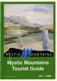
Ephemera (Item) - Tourist Guide, Michael Nash et al, Mystic Mountains Tourist Guide Vol. 1 1994, 1994
A tourist guide outlining services, accommodation, activities and places of interest to visit in and around Marysville and the local district.A tourist guide outlining services, accommodation, activities and places of interest to visit in and around Marysville and the local district.ACKNOWLEDGEMENTS:/ Marysville and District Tourist and Progress Association, Marysville/ Office of the Department of Conservation & Natural Resources, Shire/ of Alexandra Visitors Guide and all our advertisers whom without/ their support this publication would not have been possible.marysville, victoria, australia, tourist guide, mystic mountains, michael nash, dudley jones, marysville and district tourist and progress association, department of conservation & natural resources, shire of alexandra, paperwork professionals, pp art services, harrier printing, darrowby deer farm, heidi boesch, hidden talent craft gallery, olde yarra track shoppe, lady talbot forest drive, mathilde's of marysville country guest house, wishing well, taggerty river picnic area, taggery river, phantom falls, keppel falls, the beeches walking track, mount sugarloaf, beauty spot walk, tree fern gully walk, michaeldene track, keppel track, woods lookout track, marysville caravan park, baree mud brick cottages, cumberland scenic reserve, nanda binya lodge, cambarville, the big tree, barton's lookout, cumberland falls, our lady of the snows catholic church, anglican church christ, marysville christian fellowship, sovereign view, the big culvert, st fillan, steavenson's restaurant, the birches resort, cathedral range state park, tower motel, marysville post shop, lake mountain, wirreanda festival, cross country ski hire, marysville hotel motel, kerami house, marysville holiday cottages, missing links miniature golf, top shop pancake parlour, marylands guest house, dalrymples guest cottages, crossways country inn, esa camping & conference centre, scenic motel, the cumberland, maryton park holiday cottages, lomatia lodge holiday house, willowbank gallery and art centre, igloo roadhouse, a model tours, geoffrey pope & associates -
 Marysville & District Historical Society
Photograph (Item) - Black and white photograph, Unknown
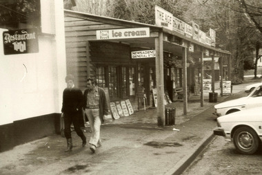
... in Marysville in Victoria. Shows two men walking along the footpath just... to operate until sometime in the 1970's. marysville victoria barton's ...A black and white photograph of Barton Bros Store in Marysville in Victoria.A black and white photograph of Barton Bros Store in Marysville in Victoria. Thomas John Barton was born in 1836 in Gloucestershire and after his father died in 1850 arrived in Melbourne in 1852 along with his mother, adult sisters, younger brothers, his uncle, his uncle's wife Suzanna and their family. Thomas tried gold mining at Woods Point but found it too difficult. He then partnered with Ewen Hugh Cameron to provide the miners with meat. In 1864 they purchased a plot of land in Marysville and set up a butchers/abattoirs and from there began their business of taking supplies to the miners at the nearby Woods Point and Jamieson goldfields. In 1865 the business was firmly established and Thomas married Selina Croker at Heidelberg and brought her back to Marysville. Their first home was 'The Chestnuts', which included the store, and was situated on the town side next to the Steavenson River. Sadly, in 1876 Selina died of complications after giving birth to their sixth child. Thomas was in need of a nanny to care for his six children, including the newborn baby, and so he employed Emily Ada Sparke, who is the eldest daughter of the local school teacher. Thomas and Emily subsequently marry in 1878 and they go on to have a further 10 children over the next several years. Thomas assisted in the establishment of the first school in Marysville in 1870 and remained a very active member of the community including as a Councillor for the Shire of Healesville, Shire President and he was also appointed as a Justice of the Peace. Thomas died in Carlton in 1911. After their father's death, his sons Fred and Frank took over the family business, which was then known as Barton Bros Store which continued to operate until sometime in the 1970's.marysville, victoria, barton's store, thomas john barton, ewen hugh cameron, woods point, jamieson, gold mining, goldfields, selina croker, the chestnuts, emily ada sparke, shire of healesville, fred barton, frank barton, barton bros store, francis adam barton, frederick john barton, photograph, barton's garage, barton bros stables -
 Flagstaff Hill Maritime Museum and Village
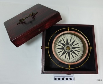
Functional object - Compass, mid-19th Century
Captain Robilliard: James Arthur Robilliard was a sea captain and tentmaker, born on the 19th April 1843 at Saint Helier, Jersey. He trained there in his father's sail loft as a sailmaker. His first job as a sailor was in Liverpool, England and 1875 James Robilliard migrated to Australia as mate on the "E.M. Young". James Robilliard and his family were amongst the early settlers that arrived along the Curdies River in the Heytesbury district of Western Victoria. In 1877 he became a Captain and would have used his compass from ship to ship. On 28th May 1877 in that same district a small 3-masted, schooner the "Young Australian" was wrecked. This schooner had been built 1864 at Jervis Bay, NSW. She had been on her way from Maryborough Queensland to Adelaide, under the command of Captain Whitfield, when she lost her mainmast in a heavy gale. She was beached at Curdies Inlet in Peterborough, Victoria, Captain Robilliard was placed in charge of the salvaging operation and recovered a good portion of the cargo. Not long after this incident a Warrnambool shop owner David Evans found employment for James Robilliard with Evan Evans, who produced tents, sails, tarpaulins and similar goods; James already had the necessary skills for this work. Evan Evans was the same sailor rescued from the “Young Australian” soon after his rescue Evan recalled he had a relative in Australia in a town called Warrnambool and while walking in Timor Street, Warrnambool, he saw a sign over a shop that said “David Evans” and once the two men met, Evan was warmly welcomed. David then helped his relative to establish a tent and tarpaulin-making business there. Evan later transferred his successful business to a shop in Elizabeth St, Melbourne, under the name Evan Evans Pty. Ltd.) James Robilliard, a committed Christian, and accredited Lay Preacher with the Methodist Church. He travelled around the local district leading the settlers in worship. On 14th November 1879, Captain Robilliard married Helen Beckett. Alfred and Selina Beckett and their family all attended the church at Brucknell where Captain Robilliard preached. He was said to have been taken by their young daughter Helen. James and Helen had ten children; James Arthur (Jnr), Henry William, Nellie Jessie, Alfred Albert, Rubena Nellie, De Jersy Norman, Clifford Beckett, Olive Ida, Frances Ridley Havergal and Nellie Elvie, all born in Victoria. In the 1880s James Robilliard captained the cutter "Hannah Thompson" into Port Campbell, Victoria. This vessel was the first coastal trader to operate between Melbourne and Port Campbell. At one time Captain Robilliard had to beach the "Hannah Thompson" for repairs. In 1923 she was blown ashore in a gale and wrecked at Oberon Bay, at Wilson's Promontory. In 1889 the compass was saved by Captain James Arthur Robilliard from his sinking brigantine "Mary Campbell" in 1889. This vessel was used to carry equipment for the Sydney Sugar Refinery's Mill in Southgate, NSW. The ship had been built in 1869 and traded for the next 20 years between Australian ports and rivers along the east coast as well as regular ports in New Zealand. She was recognised by the Sydney Morning Herald as one of the best "carrying vessel in the timber trade". She had several owners over this time, the last one being Captain James A. Robilliard. On 29th April 1889 the "Mary Campbell", with Captain James A Robilliard as captain and owner, was on her way from Clarence River, NSW to Melbourne, Victoria with a cargo of railway girders for the Melbourne Harbour Trust. Captain Robilliard encountered a storm off Port Macquarie. He sailed the vessel south to about 40km east of Cape Hawke, near Tuncurry. At around 7 pm, he discovered that the cargo had shifted during the storm and the heavy girders had damaged the hull, causing a leak. The pumps were inadequate to stem the fast-flowing leak water soon filled the hull during the next two hours. Some of the crew began throwing the cargo overboard to lighten the vessel, hoping to keep it afloat until daylight. When the water reached over 2 meters in the hull they realised their efforts were in vain. On the 30th April 1889, the crew left the vessel the ship was sinking fast, so they made for the shore. While still miles off Cape Hawke all seven crew members, including the Captain, were rescued by the Government Tug "Rhea" and taken to Port Macquarie Hospital and later returned to Sydney in the vessel "Wellington". No cargo had been saved and the consignment had been under-insured, only covered for half its value. The name of the last ship Captain Robilliard sailed is currently unknown, however, he sailed that ship from the port of Marlborough, Queensland, carting steel railway girders for the Geelong-to-Camperdown railway line. On this trip the ship hit a storm, the cargo shifted and the ship was wrecked along the NSW coast. After this, Captain Robilliard retired from the sea and began farming in Peterborough. In about 1897, verging on retirement, Capt. Robilliard superintended the Melbourne Sailors’ Home in Spencer Street, Melbourne, before being asked to leave this position in 1902 for trying to shut down a local hotel. On 6th May 1917 Captain James Arthur Robilliard J.P. died at Blackwood Park, in the Cobden district of Brucknell, the first Robilliard family homestead in Australia. He was buried in the Melbourne General Cemetery, Victoria. His wife Helen passed away in 1947. This compass, once belonging to Captain James Arthur Robilliard, is of local and state historical significance for its use by the Captain with his vessel the "Mary Campbell", a trading vessel that was bringing railway girders to the Melbourne Harbour Trust. He also used this compass on the "Hannah Thompson", listed on the Victorian Heritage Register and known as being the first coastal trader to operate between Melbourne and Port Campbell. The compass is also a very fine example of maritime navigational instruments manufactured and used in the mid-19th century. Marine compass, brass, in wooden box with separate, fitted lid. The compass card has sixteen points. The four principal points are marked; North with a star shaped, South with an “S”, East with and “E” and West with an “O” (French word OUEST). Each quadrant of the circle is numbered from 0 – 90 degrees. The card is floating in a liquid. The compass gimbal is attached to the sides of the box and to the front and back of the compass’ cylindrical brass frame. The mahogany coloured timber storage box is joined with brass nails. The centre of the lid has a folding decorative brass handle. The lid fits over base and closes with a brass screw and hook on both front and back. Maker; Dubas Watchmaker Optician, Nantes, France, c 1860-1870. Compass came from the ship “Mary Campbell”, which sank off the NSW coast in 1889, near Forster. The compass, as well as the ship, belonged to Captain James Arthur Robilliard and was donated by his family. “DUBAS MANTES” stamped into side of gimbal. “DUBAS HORLOGER OPTICIEN. NANTES.” printed around centre of card. flagstaff hill, warrnambool, shipwrecked coast, flagstaff hill maritime museum, maritime museum, shipwreck coast, flagstaff hill maritime village, great ocean road, marine compass, navigation instrument 19th century, marine instruments, dubas mantes, captain james arthur robilliard, j.a. robilliard, helen beckett, ship young australian, ship young australia(n), ship hannah thompson, ship mary campbell, melbourne sailors home, david evans, evan evans, curdies inlet, brucknell church, curdies railway, great lakes museum -
 Flagstaff Hill Maritime Museum and Village
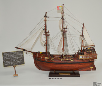
Craft - Ship Model, Portuguese Carvel, 1999
The Mahogany Ship is today regarded as a legend and refers to an ancient wreck that is purported to lie beneath the sand beside Armstrong Bay, several kilometres west of Warrnambool, Its location is currently unknown. For well over a century the mystery of this ship has fascinated Australians because the existence of such a vessel could throw a different light on the earliest phases of exploration of eastern Australia by Europeans. The story is that in January 1836 a party of whalers from Port Fairy travelled to the mouth of the Hopkins River in search of seals. Their boat overturned and one man was drowned. The three survivors were walking the 30 kilometres back to Port Fairy along the coast when, about halfway along, they discovered the wrecked ship in the dunes. It is said that Captain John Mills, who was in charge of the whaling station at Port Fairy promptly visited the wreck with several of his men, including Hugh Donnelly. Donnelly who was the originator of that version of events is now regarded as unreliable. Local history researcher Joan Fawcett believes Donnelly could not have visited the wreck in 1836 because he did not arrive in Victoria until 1841. The "mahogany" description can be traced to a letter from Port Fairy builder, architect and surveyor John Mason and published in the Melbourne Argus in 1876. He said he had seen the hull in 1846 and it "had the appearance of either cedar or mahogany." In 1884 Argus journalist `The Vagabond' wrote that the hull was built of "Spanish mahogany" and six years later Mason wrote another letter saying it might not have been mahogany but red gum or ironbark from New South Wales. He was too late with this new description as the wrecks mahogany tag was here to stay all through the hull was not visible as it had disappeared beneath the shifting sands by 1880. A more reliable account was later presented by the former editor of the Warrnambool Examiner, historian Richard Osburne, who wrote about the wreck in his book History of Warrnambool (published 1887). In it the author remembers to have noticed a wreck in the hummocks between Belfast and Warrnambool, in 1847 or 1848; he stated it was much nearer Warrnambool than Belfast, now known as Port Fairy, going on to state “in fact, it was only two or three miles from the former place, to the west of the big hummock which was supposed to fill Warrnambool Bay with drift sand washed by the Merri River before the cutting was made.” Osburne followed up with a letter to the Port Fairy Gazette on June 25, 1876, during a period of heightened interest in the wreck, although he was unsure of the provenance of the ship he went on to state in his letter. “The old wreck was, in fact, miles away from the Port Fairy beach, and only about four miles from Warrnambool. In the years 1847 and 1848. I have often seen the wreck and I regret to say I do not believe she was a foreign ship at all.”The ship model is significant for its association with the Warrnambool story of what is now referred to as the Mahogany Ship, an ancient shipwreck. The model is significant as it is an interpretation of a Portuguese caravel and possibly associated with the early history and exploration of Southern Australia. The model is a fine example of a hand crafted ship made from plans, not from a kit. Some of the materials used for the model are significant to the Gembrook community in that the timber used is a portion from a 30-meter pine tree that fell onto and destroyed the 120-year-old Gembrook church building. The model is also a dedication to Edward Kermond, who grew up in Warrnambool and claimed to have seen the shipwreck in the dunes when he was a lad in the late 19th century. (See note section of this document for further information on the creator and donation of the subject item).Ship model, an interpretation of a mahogany Portuguese carvel vessel in a glass display case with wood frame and a description plaque. Model is made from dark stained wood. The three masted vessel is fully rigged, with a Portuguese-like flag on mast. Plaque is rectangular, free standing on a pedestal. The model was handmade by Joe Hilder (Senior) in 1999 from flooring obtained from the Gembrook Uniting Church in Victoria. Inscriptions, hand written, under base of case and on plaque.Under base, black felt tip pen “Ship & Case made From / Flooring from Gembrook uniting Church, Flattened in 1999 / By Large Pine Tree.” On plaque, white paint "This interpretation of the Fabled Mahogany Ship was made by Joe Hilder, Gembrook Vic. is displayed in the memory of the late Edward Kermond (Ted) 1887-1973, a Warrnambool son who claimed to have seen the original ship as a child." flagstaff hill, warrnambool, flagstaff hill maritime museum, shipwreck coast, flagstaff hill maritime village, great ocean road, ship model, mahogany ship, mahogany ship story, portuguese caravel, joe hilder, edward kermond, ted kermond, gembrook uniting church, gembrook storm 1999, port fairy whalers, belfast whalers -
 Phillip Island and District Historical Society Inc.
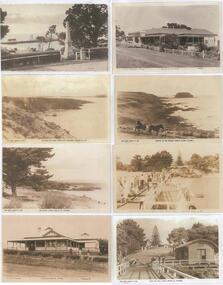
Photograph - Post Cards, Rose Series et al, Early 20th Century
One of 15 A3 sheets with copies of postcards on each page. Shirley Jones Collection.Copies of Postcards: Left side from top to bottom: 1. Cowes War Memorial with Jetty in the background. 2. View of San Remo from Cape Woolamai. 3. Cowes Sea Baths. 4. Douglas House Cowes. Right side from top to bottom: 1. Phillip Island Hotel Cowes. 2. Looking towards the Nobbies - man in horse drawn jinker with dog in front of horse. 3. People walking down the Cowes Pier after the departure of a boat. 4. Taken from the pier looking toward the Jetty Shed and Cowes.Left side from top to bottom: 2. "The Rose Series P680 - towards San Remo from Cape Woolamai P.Is". 3. "The Rose Series P660 - the Baths Cowes Phillip Island". 4. "H. Donn Proprietor Douglas House Cowes Telephone 25". Right side from top to bottom: 1. "Photo Shop Series No 29 - Phillip Island Cowes". 2. "the Rose Series P666 - Looking to The Nobbies Phillip Island Victoria". 3. "Valentine Series M4911 - After the departure of the boat Cowes P.Isl." 4. "The Rose Series P656 - From the Pier Cowes Phillip Island Vic."cowes war memorial, cowes baths phillip island, douglas house cowes, cowes pier phillip island, the nobbies phillip island, view san remo, shirley jones collection, thelma astbury -
 Phillip Island and District Historical Society Inc.
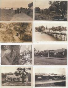
Photograph - Post Cards, Rose Series, Early 20th Century
One of 15 A3 sheets with copies of postcards on each page. Shirley Jones Collection.Copies of postcards: Left side from top to bottom: 1. A group of people walking down Cowes Main Street. 2. Lovers Walk Cowes. 3. Lovers Walk Cowes. 4. Clovelly Guest House Cowes. Right side from top to bottom: 1. Lovers Walk Cowes. 2. Looking towards Cowes from the Pier. 3 & 4. The Continental Guest House Cowes.Left side from top to bottom: 1. "Main St Cowes" 2. "The rose Series P653 - The Lovers Walk Cowes Phillip Is Victoria". 4. "No 107 'Clovelly' Cowes". Right side from top to bottom: 1. "Lovers Walk Cowes". 2. "The Rose Series P657 - Cowes from the Pier Phillip is Victoria". 3. "The Continental Cowes Phillip Island V8" 4. "No 149 the Continental Cowes".lovers walk cowes, main street cowes phillip island, clovelly guest house cowes, guesthouses, cowes pier phillip island, the continental guesthouse, shirley jones collection, thelma astbury -
 Glenelg Shire Council Cultural Collection
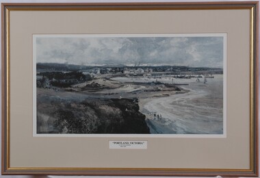
Print, Albert Henry Fullwood, Portland Victoria, c. 1886
NilScene of Portland Harbour. View includes people walking on beaches, jetties, moored boats (some with sails, some without). Upper centre of image shows a town, with a church to the right. To the left centre is a planned garden with people promenading. In foreground is empty land with a few seagulls. A train track enters the image on bottom centre. Print is predominantly in shades of blue, grey and brown. Mounted in dark cream matt, in wooden frame with glass.Front: A. Hy Fullwood (lower left, grey paint) "Portland Victoria" A. H. Fullwood 1836-1930 (printed below image) Back: (no inscriptions) -
 Mission to Seafarers Victoria
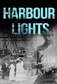
Film - Documentary, Wind and Sky Productions, Harbour Lights, 2019-2020
Synopsis: “In WW1 Melbourne a pioneering network of women at the Mission to Seafarers called the Ladies Harbour Lights Guild supported sailors who risked their lives at sea. The documentary “Harbour Lights” tells the remarkable story of the Ladies Harbour Lights Guild and the lives of seafarers in early 20th century Melbourne. It focuses on Melbourne’s iconic Mission to Seafarers building, its connection to the Great War and to a unique community of ships crew and volunteers. Featuring Melbourne historians, commentators, archivists and architects and rare footage and images of sailing and social life in and around the ports of Melbourne, this film will inform and connect audiences young and old.” Commissioned by Victorian Government The movie was produced in collaboration with the Mission to Seafarers Victoria. It was directed by Jary Nemo and written and produced by Lucinda Horrocks and Jary Nemo with executive producers Sue Dight and Gordon MacMillan. The film features: Jill Garner Kate Darian-Smith Chris McConville Janet Miller (curator) Gordon MacMillan (former seafarer and board committee member) Narrated by Sharon Turley. Music by Richard Chew (professor of the Arts Academy in Ballarat) The film was presented at several festival in Australia and abroad in 2020-2021. Credits: Narrator Sharon Turley Featuring (in order of appearance) Dr Chris McConville, Gordon MacMillan, Janet Miller, Professor Kate Darian-Smith and Jill Garner With Raul S Gantalao Jr, Escoto Lemuel, Ben Schroeder, Cinda Manins And Ian Fletcher, Yuan Jia, Uma Kothari, Gordon Lansley, William Reed and Cheka Samaranayake Directed by Jary Nemo Written and Produced by Lucinda Horrocks and Jary Nemo Music by Richard Chew Executive Producers Sue Dight and Gordon MacMillan Research advisors Geraldine Brault, Maria Culka, Professor Kate Darian-Smith, Ros Fletcher, Professor Uma Kothari, Dr Barbara Lemon, Catherine McLay, Dr Chris McConville, Janet Miller, Rick Mitchell, Duncan ‘John’ Perryman, Dr Annette Sheill and Peter Taylor Archival photographs, music and footage courtesy of Australian Red Cross Society, Central Highlands Libraries, Internet Archive, National Film and Sound Archive, National Library of Australia, Mackarness Family Personal Archives, Mission to Seafarers Victoria, Public Record Office Victoria, State Library of Victoria and US National Archives Music Harbour Lights. Music by Richard Chew. Westering. Music by Richard Chew. Twilight (Crépuscule) by Jules Massenet. Performed by Amelita Galli-Curci. I Love You So, Waltz from The Merry Widow by Franz Lehár. Performed by Elise Stephenson and Harry Macdonough with Orchestra. Harbour Lights 2. Music by Richard Chew. If I Could Fly by Walking Hearts featuring Jennifer Holm. Courtesy of Epidemic Sound. With thanks to Peter Barrow, Sarah Bartak, Lin Bender AM, Patty Braumueller, Csilla Csongvay, Emer Diviney, Moira Drew, Ian Fletcher, Ajith Jayasuriya, Ben Jones, Patience Jones, Cinda Manins, Madeleine Martiniello, Georgia Melville, Elisabeth Moglia, Tara Oldfield, Lyn Pasquier, Nigel Porteous, Rev’d Onofre (Inni) Punay, Dr Rosalie Triolo, Ben Schroeder, David Simpson, Cheka Samaranayake, Daria Wray, the Helen Macpherson Smith Trust and KPMG. A special thanks to The women of the Ladies Harbour Lights Guild 1906 to 1961 Produced in collaboration with The Mission to Seafarers Victoria Created with the support of The Victorian Government Licensing This film has been released under a Creative Commons BY-NC-ND 4.0 International license Acknowledgement of country Project production and development took place on the lands of the Kulin nation. We acknowledge Traditional Owners and pay our respects to Elders past, present and future. Production company A Wind & Sky Production Copyright with © Wind & Sky Productions MMXIX The film was launched on Wednesday 26th February 2020 at the Mission. Speech by Veterans Affairs. Amongst the guests were current and former volunteers (Maria Culka, Gordon MacMillan, Elisabeth Moglia), curators (Georgia Melville, Jay Miller, Geraldine Brault)18mn documentary mixed of photographs from teh collection and interviews about the Ladies Harbour Lights Guild work during WWIladies harbour lights guild, documentary, jay miller, janet miller, geraldine brault, lucinda horrocks, gordon macmillan, jary nemo, kate darian-smith, jill garner, chris mcconville, sharon turley, richard chew, footage, archive -
 Mission to Seafarers Victoria
Photograph - Photograph, Colour, 1991?
The centre is at the main dock gate (Corry Road) within easy walking distance of most ships on North Shore. Facilities include a Flying Angel Centre with free Wifi & computer access, a bar and café, currency exchange, a choice of mobile phone & internet cards, pool table, chapel, gift shop, clothes shop and lounge area. Belfast is one of the many centres from the Mission to Seafarers network around the world.Mission located in the docks in Belfast North Ireland. Behind is the St Joseph's Church Sailortown.mission to seafarers, seamen's mission, mission to seamen, belfast, north ireland, ports -
 Mission to Seafarers Victoria
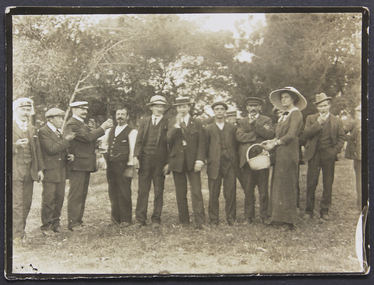
Photograph, Joan Bagot distributes fruit at picnic
Joan Bagot distributing fruit to seafarers at one of the many mission picnicsSmall monochrome outdoor photograph, depicting a lady holding a basket and walking along a row of 10+ men Fruit being distributed at picnic. Miss Bagot. Joan Bagotjoan bagot, bagot, fruit, picnic, lhlg -
Lorne Historical Society
Pamphlet - Tourist pamphlet Lorne, Lorne Victoria Australia
Victorian Railways printed a series of brochures publicizing holiday destinations.A folded paper souvenir pamphlet. The cover is a colored picture of Lorne from Scotsman’s Hill with two bathing suited young women in the foreground, and a blurb extolling the virtues of Lorne. On the back is a red, yellow and blue map of Lorne and district. Inside are eight black and white photographs of Lorne attractions,; the Main Street, tennis courts, Erskine River, walking tracks and the George River with the phrase ,” The resort that embraces everything for the perfect holiday.”souvenirs, pamphlets, victorian railways, -
 Mission to Seafarers Victoria
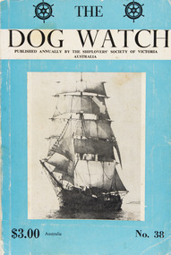
Journal (item) - Periodicals-Annual, Shiplovers' Society of Victoria, The Annual Dog Watch
This journal provides the reader with glimpses of the adventures and hardships of a seaman's life. Many of the stories are of sailing ships.Contributes to our knowledge of the importance of shipping and places on record those stories of the sea which would otherwise be lost.Contents Foreword - D. Baillieu - 5 Editorial - S. A. E. Strom - 7 Figureheads - Captain G. Heyen - 13 The Polly Woodside - C. E. Bonwick - 15 The Sinking of A.U.S.N. Steamer "Macumba" - Captain J. D. V. Young - 16 The Real Hero of Quebec The Last Voyage of "Unicorn" Under the American Flag - D. Hannaford - 23 My Mother and Eva Carmichael - A. A. McArthur-Campbell - 30 The "Lauristan" -- Taltal to the Horn - R. W. Rudd - 34 A Sea-Water Mystery - Captain Leif Asklund - 38 Walking Backwards - T. Devaney - 40 Encounter With a Rum-Runner - Captain G. Chapman - 46 The Bosun - R. N. Thiele - 50 Crossing the Equator in a Ship's Boat - Captain Yuri Shemansky - 56 "Going Down the Bay" K. Bull - 59 Voyage in the Clipper "Yorkshire" in 1968 - R. Duruz - 62 A Dream Come True - W. P. Shemmeld - 64 The Mahogany Ship Mystery - J. M. Mackenzie - 68 Things Drake Never Did - E. Harper - 74 "Desdemona" - Captain D. Cowling - 76 A Naval Ploy - Revd. G. H. P. Karney - 90 Echoes of the Travelling Past - S. A. E. Strom - 91 Sail Training For Australia -- Now A Reality - R. Carter - 94 Northern Adventure -- The "Japan" - Captain H. O'May - 98 The Sea - Sire Robert Garran - 100 Voyage of the "Tillicum" - Captain H. W. Watson - 101 Sheepwash - Captain W. Eglen - 103 The Wreck of the "City of York" - E. M. Christie - 104 Wreck of the Barque "Eleanor Lancaster" - C. Dickson Gregory - 109 The Legend of Campbell Island - Captain H. O'May - 110 Book Reviews - 112sailing ships, steamships, shipping, seafaring life, shiplovers' society of victoria, dog watch -
 Phillip Island and District Historical Society Inc.
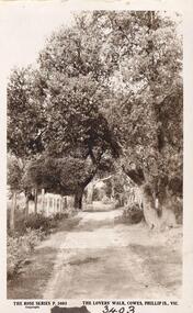
Photograph
Part of collection donated to the Museum by Mr. Bernard Grayden. 1975Postcard of track known as Lover's Walk through trees along foreshore at Cowes, Phillip Island."The Lover's Walk, Cowes, Phillip Island, Victoria". The Rose Series. P 3403local history, documents, postcards, walking track, cowes, phillip island, sepia postcard, lover's walk cowes, bernard grayden -
 Mission to Seafarers Victoria
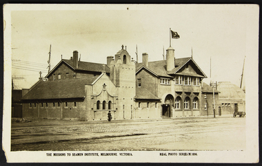
Postcard - Postcard, Sepia, Valentines Real Photo Series, The Missions to Seamen Institute, Melbourne Victoria, c. 1922
This postcard depicts the urban setting of the Mission to Seafarers a few years after its construction. (the Dome, the last part erected, was opened on 21 October 1921). It demonstrates a lack of urban surrounds or buildings as well as a paved road and a horse-drawn wagon. The figure in the photo is also a record of the dress style of the era. The lady is most likely a member of the Ladies' Harbour Lights Guild.This postcard demonstrates that the building was deemed important enough to be photographed for a postcard. It is a record of what the Mission to Seafarers looked like two years after its construction, and its urban surrounding.Sepia postcard of the Mission to Seafarers building complex and surrounding streets. The postcard depicts a wagon and a woman walking by the complex wearing a black dress and coat and black hat and holding an umbrella. Front: THE MISSIONS TO SEAMEN INSTITUTE, MELBOURNE VICTORIA REAL PHOTO SERIES.M.1696 Reverse: PUBLISHED BY THE VALENTINE & SONS PUBLISHING CO.LTD / MELBOURNE SYDNEY & BRISBANE. Contains logo of VALENTINES REAL PHOTO SERIES POSTCARD. Stamp logo lists: BRANCHES / SYDNEY / LONDON / DUNDEE / DUBLIN / CAPETOWN / MONTREAL / TORONTO Handwritten in blue: 1919mission to seafarers, melbourne, mission to seamen, seamen's mission, norla dome, flag, flying angel, lady, horse cart, umbrella, flinders street extension, ships, australian wharf, valentine's postcards, real photo series postcards, st peter chapel, lhlg, architecture, walter richmond butler -
Glenelg Shire Council Cultural Collection
Postcard - Postcard - Lighthouse and harbour Portland Victoria, n.d
Postcard, Lighthouse & Harbour, Portland, Victoria, from the "Rose" series ----colourview No 503, showing adult & three children walking on an unsealed road north of Whaler's Bluff. -
Glenelg Shire Council Cultural Collection
Book, Thistle Y. Harris, Naturecraft in Australia, 1956
... of Victoria outdoors nature bush walking Australia Front: Public ...Brown cloth-covered binding with section of dustjacket glued to front cover. Title and author on spine in black lettering. 264pp.outdoors, nature, bush walking, australia