Showing 2841 items
matching wests road
-
 Ringwood and District Historical Society
Photograph, Holy Spirit School, North Ringwood, viewed from Jull Road - 1981
... Written on back of photograph, "E620. 1981. Looking west..., "E620. 1981. Looking west from Jull Road. North Ringwood at Holy ...Written on back of photograph, "E620. 1981. Looking west from Jull Road. North Ringwood at Holy Spirit School". -
 Melbourne Tram Museum
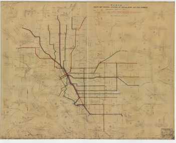
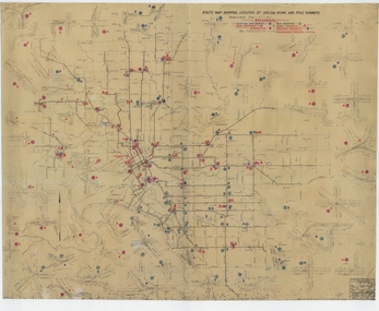
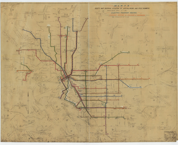
Drawing, Melbourne & Metropolitan Tramways Board (MMTB), "Route Map showing location of special work and pole numbers" "All night tram routes in colours", late 1941
... to Maribyrnong Munitions works along Cordite Ave and Wests Road...Melbourne Tram Museum 8 Wallen Road Hawthorn melbourne Map ...Map of the system shown at two inches = 1 mile. Drawing No. P5799. Shows crossovers, track layouts at junctions, signal cabins roads, railways, and stations. Originally signed by Perway Engineer - 20/12/1940, though originally drawn in 1922. Has been marked up in colour pencil to show the all-night routes and the individual services. The plan shows the lines to Maribyrnong Munitions works along Cordite Ave and Wests Road and the track from Moonee Ponds to Union Road, opened in July 1941, but not the extension to Essendon Airport built in 1942.Demonstrates a detail drawing of Melbourne tramways, junctions and pole numbers.Drawings - dyeline cloth-backed print - titled - "Route Map showing the location of special work and pole numbers" and subtitled - "All night tram routes in colours". trams, tramways, mmtb, trackwork, tramways, junction, map, world war 2, night trams -
 Melbourne Tram Museum
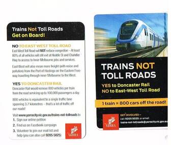
Ephemera - Transport Cards, City of Yarra, "Trains not Toll Roads", c2012
... not Toll Roads", Yes to Doncaster Rail, No. to East-West Toll Road...", Yes to Doncaster Rail, No. to East-West Toll Road, published ...Two full colour Transport (policy) cards, titled "Trains not Toll Roads", Yes to Doncaster Rail, No. to East-West Toll Road, published by the City of Yarra, c2012. Has political policy position of the Council on the rear. Front has a photo of a European train, but destination of Doncaster.trams, tramways, city of yarra, toll roads, doncaster -
 Whitehorse Historical Society Inc.
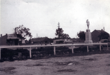
Photograph, Mitcham War Memorial
... in the centre plantation west of Mitcham Road & Whitehorse road... plantation west of Mitcham Road & Whitehorse road intersection ...The Mitcham War Memorial is now located in Halliday Park.in Mitcham Road.Black & white photo of the Mitcham War Memorial in the centre plantation west of Mitcham Road & Whitehorse road intersection. Allan's Butcher shop is on the left and the Post Office on the right.war memorial mitcham, war memorials -
 Melbourne Tram Museum
Drawing, Melbourne & Metropolitan Tramways Board (MMTB), "Route Map showing location of special work and pole numbers" "substations", late 1942
... Cordite Ave and Wests Road and the track from Moonee Ponds... Munitions works along Cordite Ave and Wests Road and the track from ...Map of the system shown at two inches = 1 mile. Drawing No. P5799. Shows crossovers, track layouts at junctions, signal cabins roads, railways, and stations. Originally signed by Perway Engineer - 20/12/1940, though originally drawn in 1922. The plan shows the lines to Maribyrnong Munitions works along Cordite Ave and Wests Road and the track from Moonee Ponds to Union Road, opened in July 1941, and the extension to Essendon Airport built in 1942, but not the Queen St North Essendon substation. Shows underground cables, tram and bus depot, workshop locations, and substation locations and their priority.Yields information about the MMTB substation locations in 1942.Drawing - dyeline cloth backed print - titled - "Route Map showing location of special work and pole numbers" and subtitled - "Substations". trams, tramways, mmtb, trackwork, tramways, junction, map, world war 2, substation -
 Ringwood and District Historical Society
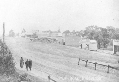
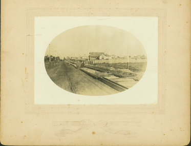
Photograph, Maroondah Highway Central, Ringwood. Looking west from Warrandyte Road, 1910
... Maroondah Highway Central, Ringwood. Looking west from... Road, Ringwood, looking west, Warrandyte Road coming in from... Road, Ringwood, looking west, Warrandyte Road coming in from ...Black and white photograph (2 copies)Written on rear of backing sheet of one photograph: "Main Road, Ringwood, looking west, Warrandyte Road coming in from right.". Image of central Ringwood including the E.S.& A. bank, Ringwood's first bank, 1910. -
 Geelong Cycling Club
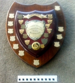
Wooden Shield, 1967
... Shield prepared to recognise winners of a Geelong West... trophy spans 3 decades on road racing with the GWCC. geelong west ...Shield prepared to recognise winners of a Geelong West Cycling Club road race in memory of Russell Wright.This perpetual trophy spans 3 decades on road racing with the GWCC.Wooden shield with small shield shapes in plated silver placed around the shield. These small plaques are inscribed with winners of this event. The shield also has a plated silver banner with inscriptions on it, plus the shape of a cyclist in a medallion at the bottom of the shield."Geelong West Cycling Club/Russell Wright Memorial Shield/ Donated by his Loving Wife/1967 R Dillon 68m59sec/1968 J Elsworthy 54mins 55secs/ 1969 T Ryan 70mins 3secs/ 1970 R Edwards 53mins26secs/1971 Geo O'Dwyer 82mins 17secs/1972 K Bunting 51min 50 secs/1973 W Mahoney 54min 20secs/ 1974 W Crookshanks 83min 28secs/ D Ferguson 83 mins 47 secs/ 1976 S Jennings/ 1977 R Bunting 51mins 50 secs/ 1978 - /1979 Don Wilson/1980 Rodney Baker/ 1981 David Carnegie/ 1982 -/ 1983 Neville Williams/ 1984 Tony Pickles/ 1988 Ian Hendry"geelong west cycling club; gwcc; russell wright memorial shield; 1967; r dillon; 1968; j elsworthy; 1969; t ryan; 1970; r edwards; 1971; george o'dwyer; 1972; k bunting; 1973; w mahoney; 1974; w crookshanks; d ferguson; 1976; s jennings; 1977; r bunting; 1978; 1979; don wilson; 1980; rodney baker; 1981; david carnegie; 1982; 1983; neville williams; 1984; tony pickles; 1988; ian hendry; -
 Bendigo Historical Society Inc.
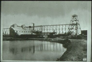
Slide - ALBERT RICHARDSON COLLECTION: SOUTH NEW MOON GOLD MINE, EAGLEHAWK
... Slide. South New Moon Gold Mine, situated west..., situated west of Beezlebub Road, Eaglehawk. Poppet head, trestleway ...Slide. South New Moon Gold Mine, situated west of Beezlebub Road, Eaglehawk. Poppet head, trestleway ,engine/boiler house, chimney stack, large dam in foreground .No. 24 on bottom of slidemine, gold, south new moon., bendigo mines-jack hattam collection -
 Whitehorse Historical Society Inc.
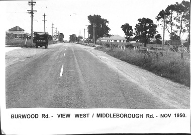
Photograph, Burwood Road - 1950, 1/11/1950 12:00:00 AM
... 1950 - View west corner of Middleborough Road, November 1950.... west corner of Middleborough Road, November 1950. Burwood Road ...Black & white photograph taken of Burwood Road in November 1950 - View west corner of Middleborough Road, November 1950.burwood road, burwood, middleborough road -
 Whitehorse Historical Society Inc.
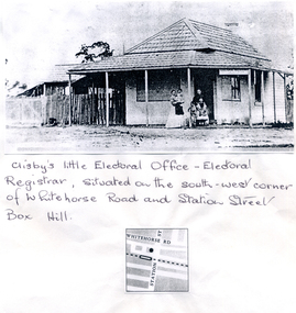
Photograph, Clisby's Electoral Office
... on South-West corner of Whitehorse Road and Station Street, Box...Whitehorse Historical Society Inc. 2-10 Deep Creek Road ...Clisby's Electoral Office - Electoral Registrar. Situated on South-West corner of Whitehorse Road and Station Street, Box Hill.clisby, electoral officers -
 Eltham District Historical Society Inc
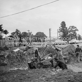
Negative - Photograph, J.A. McDonald, Eltham, Cecil Street, Sep. 1959
... looking west across Main Road to the railway line... looking west across Main Road to the railway line Record ...Stabilising junction with Eltham-Yarra Glen Road View looking west across Main Road to the railway lineRecord of various Shire of Eltham infrastructure works undertaken during the period of 1952-1962 involving bridge and road reconstruction projects, sometimes with Eltham Shire Council Project Reference numbers quoted. It was during this period that a number of significant improvements were made to roads and new bridges constructed within the shire that remain in place as of present day (2022). In many situations, the photos provide a tangible visible record of infrastructure that existed throughout the early days of the Shire. The album was put together by or under the direction of the Shire Engineer, J.A. McDonald.infrastructure, shire of eltham, road construction, cecil street, eltham, eltham-yarra glen road, main road, 1959-09 -
 Melbourne Tram Museum
Drawing, Melbourne & Metropolitan Tramways Board (MMTB), "Route Map showing location of special work and pole numbers" "Electric Tramway Routes - showing routes in colours and numbers", late 1941
... Cordite Ave and Wests Road and the track from Moonee Ponds... to Maribyrnong Munitions works along Cordite Ave and Wests Road ...Map of the system shown at two inches = 1 mile. Drawing No. P5799. Shows crossovers, track layouts at junctions, signal cabins roads, railways and stations. Originally signed by Perway Engineer - 20/12/1940, though originally drawn in 1922. Has been marked up in coloured pencil to show the routes and route numbers. The plan shows the lines to Maribyrnong Munitions works along Cordite Ave and Wests Road and the track from Moonee Ponds to Union Road, which opened in July 1941, but not the extension to Essendon Airport built-in 1942. See Reg Item 1561 for a 1963 version and 1683 for a 1987 versionDemonstrates the use of a MMTB drawing to show tram routes and their route numbers at the time.Drawings - dyeline cloth backed print - titled - "Route Map showing location of special work and pole numbers" and subtitled - "Electric Tramway Routes - showing routes in colours and numbers". trams, tramways, mmtb, trackwork, tramways, junction, map, world war 2 -
 Kew Historical Society Inc
Photograph - Construction of the electric tram line in Riversdale Road, Surrey Hills, E.J. Dower, 1916
... for electric tram line / Taken just west of Middlesex Road, looking... / Taken just west of Middlesex Road, looking west" Digital copy ...Contextual or historic information One of a series of photographs, taken by Edgar James Dower in the second decade of the twentieth century. Born and raised in Olinda, his family later moved to Surrey Hills. He worked as an adult as a clerk in the city office of the Metropolitan Gas Company, and in his role as a 'collector', he was able to photograph scenes including the construction of tramlines and associated buildings in Kew, Hawthorn, Camberwell and Surrey Hills. Later he established a real estate agency with his brother - the E.J. Dower Real Estate Agency, Dandenong Office.The image is an historically significant record of the development of transport infrastructure which was used to connect Victorians in the first two decades of the twentieth century. This development resulted from increases in population and the consequent extension of Melbourne's suburbs. The photographs, both individually and collectively, richly detail the labour of workers and the tools and machinery used to create and extend Melbourne's tram network in the years preceding and during World War 1.Digital copy of an original oval mounted photograph depicting preparation for laying the tracks for the new electric tramline in Riversdale Road, Surrey Hills. Annotated verso: "Riversdale Road Surry Hills / preparing for electric tram line / Taken just west of Middlesex Road, looking west"theme --- travelling by tram, theme -- connecting victorians by transport and communications, trams -- boroondara (vic.), riversdale road -- surrey hills -
 Melton City Libraries
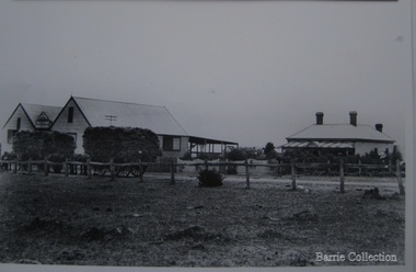
Photograph, Chaff cutting and hay-pressing mills, 1909
... Owned by C.E Barrie. Buildings were on the west side... on the west side of Station Road in Melton South, 100 metres north ...In the early 1900’s Charles Ernest Barrie and his brother Ted were in partnership in a Chaff cutting and Ha y processing Mill on the corner of Station and Brooklyn road Melton South. By 1906 Charles Ernest and James Edwin were in partnership in the Station Road mill when a connecting rail line across Brooklyn Road for a siding was constructed to the Melton Railway Station. In 1911 the Mill’s letterhead shows C.E. BARRIE Hay Pressing and Chaff Cutting Mills. This Mill as sold to H S K Ward in 1916 and stood until 1977 when it burnt down in a spectacular fire.Owned by C.E Barrie. Buildings were on the west side of Station Road in Melton South, 100 metres north of Brooklyn Roadlocal identities, pioneer families, agriculture -
 Eltham District Historical Society Inc
Photograph - Aerial Photograph, Landata, Eltham, Vic, Apr. 1963
... Park West Road... to south, Research Shops to east and Glen Park Road and Park West... to south, Research Shops to east and Glen Park Road and Park West ...Centred on present day Floriston Grove, Eltham bounded by Maroondah Aqueduct to north, Thompson Crescent and Diosma Road to south, Research Shops to east and Glen Park Road and Park West Road to west. Historic Aerial Imagery Source: Landata.vic.gov.au Aerial Photo Details: Project No :486 Project : MELBOURNE (1963) PROJECT Run : 5 Frame : 60 Date : 04/1963 Film Type : B/W Camera : RC8 Flying Height : 5100 Scale : 9600 Film Number : 1805 GDA2020 : 37°42'24"S, 145°09'29"E MGA2020 : 337622, 5825128 (55) Melways : 22 B3 (ed. 42)aerial photo, neil webster collection, eltham, 1963-04, diosma road, floriston grove, maroondah aqueduct, melway 22b3, park west road, research (vic.), research shops -
 Eltham District Historical Society Inc
Negative - Photograph, J.A. McDonald, Eltham, Cecil Street, Sep. 1959
... looking west across Main Road to Diamond Street railway crossing... looking west across Main Road to Diamond Street railway crossing ...Stabilising junction with Eltham-Yarra Glen Road View looking west across Main Road to Diamond Street railway crossingRecord of various Shire of Eltham infrastructure works undertaken during the period of 1952-1962 involving bridge and road reconstruction projects, sometimes with Eltham Shire Council Project Reference numbers quoted. It was during this period that a number of significant improvements were made to roads and new bridges constructed within the shire that remain in place as of present day (2022). In many situations, the photos provide a tangible visible record of infrastructure that existed throughout the early days of the Shire. The album was put together by or under the direction of the Shire Engineer, J.A. McDonald.infrastructure, shire of eltham, road construction, cecil street, diamond street, eltham, eltham-yarra glen road, main road, railway crossing, 1959-09 -
 Whitehorse Historical Society Inc.
Map, City of Whitehorse, 1/03/1995 12:00:00 AM
... in the west, to Heatherdale Road in the east. Prep. by Richard Meloni... and Warrigal Road in the west, to Heatherdale Road in the east. Map ...Map showing streets of the City of Whitehorse from Mullum Mullum Creek to the north to Highbury Road and Warrigal Road in the west, to Heatherdale Road in the east.Map showing streets of the City of Whitehorse from Mullum Mullum Creek to the north to Highbury Road and Warrigal Road in the west, to Heatherdale Road in the east. Prep. by Richard Meloni. Scale 1:15,000Map showing streets of the City of Whitehorse from Mullum Mullum Creek to the north to Highbury Road and Warrigal Road in the west, to Heatherdale Road in the east. city of whitehorse, mullum mullum creek -
 Whitehorse Historical Society Inc.
Photograph, Narmara Primary School, 13/01/1994 12:00:00 AM
... Coloured photo of Narmara Primary School, looking West...Whitehorse Historical Society Inc. 2-10 Deep Creek Road ...Coloured photo of Narmara Primary School, looking West along Highbury Road. School on North side of Highbury Road between Middleborough and Blackburn Roads. Since demolished and site developed for housing.narmara primary school, warner, philip -
 Kew Historical Society Inc
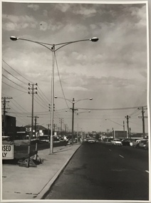
Photograph, Stuart Tompkins Studio, Electricity Supply Poles, South Road, Moorabbin, 1965
... Council. The photograph of South Road, Moorabbin, west of Jasper..., west of Jasper Road, looking east. Steel poles with two lamps.... No.2 South Road - Moorabbin, west of Jasper Road, looking east ...Research provided by Stuart Tompkins Studio, Box Hill, into alternatives for median strip street lighting to be used in Burke Road, Kew. The photographers identified variants in different suburbs appropriate to Kew's needs.The series from which the photograph is drawn provides a snapshot by a commercial photographic studio of each named vicinity in 1965 as well as providing examples of public works infrastructure being commissioned by local government in the 1960s. The photos originally formed part of the Engineering Department's files in the City of Kew before being donated to the kew Historical Society.Electricity Supply Poles, South Road, Moorabbin, 1965. Stuart Tompkins Studio provided this photograph for the Kew City Council. The photograph of South Road, Moorabbin, west of Jasper Road, looking east depicts steel poles with two lamps in a median strip and supply wires from pole to pole. The poles were described as 100′ apart. The notation on the rear of the photograph was that there were lamps along the median strip except at intersections. A wooden pole is recognised as supporting heavy supply lines across the road. The steel poles in the photograph were said to be between 3′ to 3.5′ whereas the wooden poles were three to 12.25″ in diameter. [There are three copies of this photograph in the Collection.] Typed inscription on reverse: "Electricity Supply Poles. Photographed for Kew City Council 8/2/65. No.2 South Road - Moorabbin, west of Jasper Road, looking east. Steel poles with two lamps in median strip and supply wires from pole to pole along median strip (poles only 100' apart). Lamps along median only except at intersections. Wooden pole supports heavy supply lines across the road. Wooden poles 3' up and 8 1/2" dia. Wooden poles 3' up and 12 1/2 dia." Studio stamp: "Stuart Tompkins Studio. 547 Station Street, Box Hill. WX1439."public infrastructure -- kew (vic.), city of kew - engineers department -
 Kew Historical Society Inc
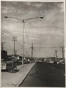
Photograph, Stuart Tompkins Studio, Electricity Supply Poles, South Road, Moorabbin, 1965
... Council. The photograph of South Road, Moorabbin, west of Jasper..., west of Jasper Road, looking east. Steel poles with two lamps.... No.2 South Road - Moorabbin, west of Jasper Road, looking east ...Research provided by Stuart Tompkins Studio, Box Hill, into alternatives for median strip street lighting to be used in Burke Road, Kew. The photographers identified variants in different suburbs appropriate to Kew's needs.The series from which the photograph is drawn provides a snapshot by a commercial photographic studio of each named vicinity in 1965 as well as providing examples of public works infrastructure being commissioned by local government in the 1960s. The photos originally formed part of the Engineering Department's files in the City of Kew before being donated to the kew Historical Society.Electricity Supply Poles, South Road, Moorabbin, 1965. Stuart Tompkins Studio provided this photograph for the Kew City Council. The photograph of South Road, Moorabbin, west of Jasper Road, looking east depicts steel poles with two lamps in a median strip and supply wires from pole to pole. The poles were described as 100′ apart. The notation on the rear of the photograph was that there were lamps along the median strip except at intersections. A wooden pole is recognised as supporting heavy supply lines across the road. The steel poles in the photograph were said to be between 3′ to 3.5′ whereas the wooden poles were three to 12.25″ in diameter. [There are three copies of this photograph in the Collection.] Typed inscription on reverse: "Electricity Supply Poles. Photographed for Kew City Council 8/2/65. No.2 South Road - Moorabbin, west of Jasper Road, looking east. Steel poles with two lamps in median strip and supply wires from pole to pole along median strip (poles only 100' apart). Lamps along median only except at intersections. Wooden pole supports heavy supply lines across the road. Wooden poles 3' up and 8 1/2" dia. Wooden poles 3' up and 12 1/2 dia." Studio stamp: "Stuart Tompkins Studio. 547 Station Street, Box Hill. WX1439."city of kew -- engineers department, public infrastructure -- kew (vic.) -
 Kew Historical Society Inc
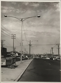
Photograph, Stuart Tompkins Studio, Electricity Supply Poles, South Road, Moorabbin, 1965
... Council. The photograph of South Road, Moorabbin, west of Jasper..., west of Jasper Road, looking east. Steel poles with two lamps... Council 8/2/65. No.2 South Road - Moorabbin, west of Jasper Road ...Research provided by Stuart Tompkins Studio, Box Hill, into alternatives for median strip street lighting to be used in Burke Road, Kew. The photographers identified variants in different suburbs appropriate to Kew's needs.The series from which the photograph is drawn provides a snapshot by a commercial photographic studio of each named vicinity in 1965 as well as providing examples of public works infrastructure being commissioned by local government in the 1960s. The photos originally formed part of the Engineering Department's files in the City of Kew before being donated to the kew Historical Society.Electricity Supply Poles, South Road, Moorabbin, 1965. Stuart Tompkins Studio provided this photograph for the Kew City Council. The photograph of South Road, Moorabbin, west of Jasper Road, looking east depicts steel poles with two lamps in a median strip and supply wires from pole to pole. The poles were described as 100′ apart. The notation on the rear of the photograph was that there were lamps along the median strip except at intersections. A wooden pole is recognised as supporting heavy supply lines across the road. The steel poles in the photograph were said to be between 3′ to 3.5′ whereas the wooden poles were three to 12.25″ in diameter. [There are three copies of this photograph in the Collection.] Typed inscription on reverse: "Electricity Supply Poles. Photographed for Kew City Council 8/2/65. No.2 South Road - Moorabbin, west of Jasper Road, looking east. Steel poles with two lamps in median strip and supply wires from pole to pole along median strip (poles only 100' apart). Lamps along median only except at intersections. Wooden pole supports heavy supply lines across the road. Wooden poles 3' up and 8 1/2" dia. Wooden poles 3' up and 12 1/2 dia." Studio stamp: "Stuart Tompkins Studio. 547 Station Street, Box Hill. WX1439."stuart tompkins studio, street lighting, south road (moorabin) 1965, public infrastructure -- city of kew, city of kew -- engineer's department -
Mission to Seafarers Victoria
Letter - Correspondence, 30/09/1948
... Air-letter has been re-addressed from 140 Brunswick Road...-letter has been re-addressed from 140 Brunswick Road, West ...Quinn CollectionBlue air-letter (0392) written by Allan and addressed to Mrs S Quinn. Letter headed 'New York, September 30', post-marked Brooklyn N.Y. 1948 and franked using red ink.Air-letter has been re-addressed from 140 Brunswick Road, West Brunswick to 5 Pollington Street, St. Kilda, Victorialetters-from-abroad, quinn, new york -
 Ringwood and District Historical Society
Photograph, Looking west across Glenvale Road, North Ringwood from No.14 1982
... Looking west across Glenvale Road, North Ringwood from No...Written on back of photograph, "21/4/82. Looking west..., "21/4/82. Looking west across Glenvale Road from No.14 at what ...Written on back of photograph, "21/4/82. Looking west across Glenvale Road from No.14 at what was once Keith Storey's property." -
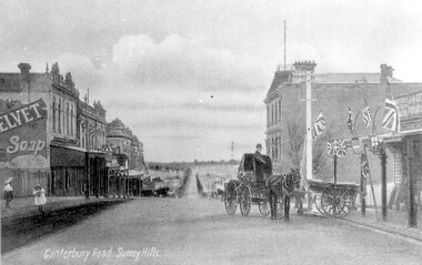 Surrey Hills Historical Society Collection
Work on paper - Photograph, Canterbury Road, near the corner of Union Road, 1911
... Road, near the corner of Union Road, looking west in 1906... terraces including Hansen's Terrace on Canterbury Road to the west ...J A Geer's grocery store operated from 1909-1912 on the site established by George Sim in 1884. He bought a house and added a shop where, in 1889, he established the first post office in the area. Prior to this residents had to go the Box Hill to collect mail. Date is approximate.This records one of the earliest businesses in Surrey Hills. To begin with, businesses developed along Canterbury Road rather than Union Road, in part because of the muddy nature of the land north of the railway line.Black and white photo taken from a postcard of Canterbury Road, near the corner of Union Road, looking west in 1906 or 1907. Two children play on the LHS of the street and there is a man on a horse and carriage, and a cart, on the RHS. Buildings on the RHS are the Surrey Family Hotel and J A Geer's grocery store; on the LHS is a row of double-storey terraces including Hansen's Terrace on Canterbury Road to the west of Union Road.On LHS within the original image is 'Canterbury Road, Surrey Hills'; on the rear in top LH corner in blue biro in Jocelyn Hall's handwriting "J H / spare"canterbury road, geer's grocery store, surrey family hotel, businesses, horse drawn vehicle, hansen's terrace, post card, mr j a geer -
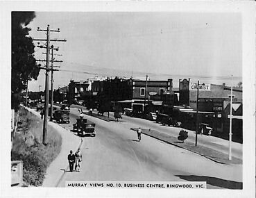 Ringwood and District Historical Society
Photograph/Postcard, Souvenir photograph - Murray Views No.10. Business Centre, Ringwood, Vic
... Warrandyte Road looking west along Maroondah Highway, Ringwood..." souvenir photograph from Warrandyte Road looking west along ...Black and white "Murray Views" souvenir photograph from Warrandyte Road looking west along Maroondah Highway, Ringwood. Circa 1940s. -
 Whitehorse Historical Society Inc.
Photograph, Mrs Jenning's Sweet Shop, C.1950s
... shops on west side of Boronia Road and south of Canterbury Road...Whitehorse Historical Society Inc. 2-10 Deep Creek Road ...Black and white photo of Mrs Jenning's Sweet Shop in group shops on west side of Boronia Road and south of Canterbury Road, Vermont.jennings, mrs., sweet shops -
 Whitehorse Historical Society Inc.
Photograph, Narmara Primary School, 13/01/1994 12:00:00 AM
... Coloured photo of Narmara Primary School site looking West...Whitehorse Historical Society Inc. 2-10 Deep Creek Road ...Coloured photo of Narmara Primary School site looking West along Highbury Road. School on North side of Highbury Road between Middleborough and Blackburn Roads. Since demolished and site developed for housing.narmara primary school, warner, philip -
Mission to Seafarers Victoria
Letter - Correspondence, 1947
... Envelope addressed to Mrs S Quinn, 140 Brunswick Road, West... 1947 Envelope addressed to Mrs S Quinn, 140 Brunswick Road ...Quinn CollectionTwo-page, double-sided letter on unlined paper (0365a1-a2) written on board S.S.Morgenster, Cape Town dated 19/12/47 with blue-lined envelope (0365.b). Pre-franked envelope using red ink by the Cape Town Mission.Envelope addressed to Mrs S Quinn, 140 Brunswick Road, West Brunswick, Victoria and franked 'The FLYING ANGELS CLUB Alfred Street Cape Town.letters-from-abroad, quinn, s.s.morgenster, 1947 -
Mission to Seafarers Victoria
Letter - Correspondence, 1948
... Brunswick Road, West Brunswick, Victoria. Post-marked New York, NY... Brunswick Road, West Brunswick, Victoria. Post-marked New York, NY ...Quinn CollectionHand-written, self-folding letter (0374), headed New York, dated 12/05/48Letter is addressed to Mrs S Quinn, C/- Mrs Blackmore, 140 Brunswick Road, West Brunswick, Victoria. Post-marked New York, NYletters-from-abroad, quinn, 1948, new york -
 Whitehorse Historical Society Inc.
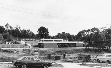
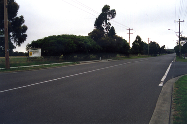
Photograph, Enterprise Way Mitcham
... photograph is looking west from Mitcham Road - 2012... Avenue.This photograph is looking west from Mitcham Road - 2012 ...Mitcham - Commercial Area behind Coles etcColoured photograph of Enterprise Way, Mitcham which is a pedestrian and service road between the shops on Whitehorse Road and Coles Supermarket and vicinity shops on Victoria Avenue.This photograph is looking west from Mitcham Road - 2012enterprise way mitcham, shops