Showing 79 items
matching wheat - agriculture
-
 Mont De Lancey
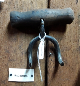
Tool - Bag Hook, Unknown
Used in the late 18th or early 19th century.A small steel double curved pointy hooked bag hook with a turned wooden handle on the top. The handle is attached through a hole in the steel and riveted to the the hook. It was used to assist with lifting large bags of wheat, fertiliser and so on in the late 18th or early 19th century. agricultural equipment, farm equipment, bag hooks -
 Wodonga & District Historical Society Inc
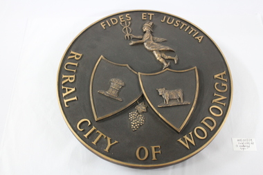
Plaque - Rural City of Wodonga Plaque
The current city was originally named Wodonga, but its name was changed to Belvoir then later back to Wodonga, its indigenous name. The original post office opened on June 1, 1856. Wodonga Shire was created in 1876 when the colonial government agreed to ratepayers' petitions to have their part severed from the Yackandandah Shire and form a new municipality. On 30th March 1973, the Wodonga Shire was granted rural city status and was officially named the Rural City of Wodonga by the Governor of Victoria, Sir Rohan Delacombe. The date this logo first came into use is unsure, but it was used prior to the granting of rural city status. In 1994, the name was retained in a new local government authority and so the Wodonga Rural City Council was born. In 1995 it was decided to give the city a fresh image, so the term 'rural' was be dropped from use except where there was a legal requirement. In December 2003, it was decided to rename the council removing the term "rural" and it is now legally Wodonga City Council. This plate is of local historic significance as it documents the way in which the local government and community has evolved and depicts itself over time.Circular metal plate for public display of status of Rural City of Wodonga. Inscription including the Latin terms for "Faith and Justice" are embossed around the circumference on the front of the plaque. The symbols of wheat, cattle and grapes represent the major agricultural pursuits of the area. A representation of Hermes/Mercury is at the top centre of the plate.Around the circumference of the plate is the inscription "FIDES ET JUSTITIA / RURAL CITY OF WODONGA"local government, wodonga, rural city, council logo -
 Wodonga & District Historical Society Inc
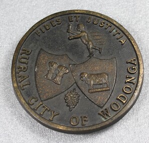
Plaque - Rural City of Wodonga Small Plaque
The current city was originally named Wodonga, but its name was changed to Belvoir then later back to Wodonga, its indigenous name. The original post office opened on June 1, 1856. Wodonga Shire was created in 1876 when the colonial government agreed to ratepayers' petitions to have their part severed from the Yackandandah Shire and form a new municipality. On 30th March 1973, the Wodonga Shire was granted rural city status and was officially named the Rural City of Wodonga by the Governor of Victoria, Sir Rohan Delacombe. The date this logo first came into use is unsure, but it was used prior to the granting of rural city status. In 1994, the name was retained in a new local government authority and so the Wodonga Rural City Council was born. In 1995 it was decided to give the city a fresh image, so the term 'rural' was be dropped from use except where there was a legal requirement. In December 2003, it was decided to rename the council removing the term "rural" and it is now legally Wodonga City Council.This plaque is of local historic significance as it documents the way in which the local government and community has evolved and depicts itself over time. Designation as a rural city was a critical event in the development of Wodonga.Small circular metal plaque for public display of status of Rural City of Wodonga. Inscription including the Latin terms for "Faith and Justice" are embossed around the circumference on the front of the plaque. The symbols of wheat, cattle and grapes represent the major agricultural pursuits of the area. A representation of Hermes/Mercury is at the top centre of the plate.Around the circumference of the plaque is the inscription "FIDES ET JUSTITIA / RURAL CITY OF WODONGA"local government, wodonga council logo, wodonga, rural city victoria -
 Victorian Harness Racing Heritage Collection at Lord's Raceway Bendigo
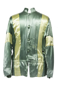
Clothing - Race colours, Bill McKenzie
W. A. (Bill) McKenzie Bill McKenzie was a Moulamein (NSW) district wheat, sheep and cattle farmer with a property of some 6000 acres. His well-known colours of green with yellow braces greeted the judge over a period of 40 years with the horses Laurie Pronto, Pedro Nell, Little June, Prancing Nell, Little Duchess and the Melbourne Showgrounds, Bendigo and Mildura Cup winner Wongala Glen. Bill travelled far and wide with his horses and was a regular competitor at country agricultural shows.Bill Mckenzie won the 1966 Bendigo Cup driving Wongala Glen.Green race colours with yellow braces and armbandsbendigo harness racing club, bhrc, bendigo, horses, bill mckenzie, bendigo cup, wongala glen, race colours, wa mckenzie -
 University of Melbourne, Burnley Campus Archives
Document - Report, John Williams, Decision-making in Australian Wheat Marketing and Price Risk Management, 2009
... Agricultural Science wheat Typed report Decision-making ...agricultural science, wheat -
 Sunbury Family History and Heritage Society Inc.
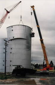
Photograph, Wheat silo, c1984
A wheat silo was erected on railway land adjacent to the Sunbury Station in 1967. Frank Millett handled the operations. As bulk handling was the preferred way to transport wheat, the silo gave local cereal growers to deliver their grain to the railhead. Over the years of the operation 200 grain wagons delivered wheat annually to the silo. In 1984 the silo was dismantled and removed.Cereal growing was one of the agricultural activities carried out in the Sunbury and surrounding areas for many years.A non-digital coloured photograph of a metal wheat silo being dismantled. A crane is beside the silo and two men are suspended from the crane in a basket to ensure that the sheets of iron land safely on the truck. wheat storage, silos, frank millett, cereal crops, sunbury railway station -
 Eltham District Historical Society Inc
Photograph - Digital Photograph, Alan King, Blue Lake, Plenty Gorge Park, 2008
A quarry was transformed into the Blue Lake. Published: Nillumbik Now and Then / Marguerite Marshall 2008; photographs Alan King with Marguerite Marshall.; p179 The dramatic steep-sided Plenty Gorge lies along the divide of two geological areas, and separates the Nillumbik Shire and the City of Whittlesea. On the Nillumbik side are undulating hills and sedimentary rock, and in Whittlesea, lies a basalt plain formed by volcanic action up to two million years ago. This provides the Plenty Gorge Park with diverse vegetation and habitats, making it one of Greater Melbourne’s most important refuges for threatened and significant species. The park, established in 1986, consists of around 1350 hectares, and extends 11 kilometres along the Plenty River, from Greensborough to Mernda. It provides a wildlife corridor for around 500 native plant and 280 animal species. The area’s plentiful food and water attracted the Wurundjeri Aboriginal people and then European settlers. By 1837 squatters had claimed large runs of land for their sheep and cattle. The Plenty Valley was among the first in the Port Phillip District to be settled - mainly in the less heavily timbered west - and was proclaimed a settled district in 1841.But by the late 1880s, the settlers’ extensive land clearing for animal grazing, then agriculture, depleted the Wurundjeri’s traditional food sources, which helped to drive them away. Many Wurundjeri artefacts remain (now government protected), and so far 57 sites have been identified in the park, including scarred trees, burial areas and stone artefacts. Pioneer life could be very hard because of isolation, flooding, bushfires and bushrangers. Following the Black Thursday bushfires of 1851, basalt was quarried to build more fire-resistant homes. Gold discoveries in the early 1850s swelled the population, particularly around Smugglers Gully; but food production made more of an impact. In the late 1850s wheat production supplanted grazing. In the 1860s the government made small holdings available to poorer settlers. These had the greatest effect on the district, particularly in Doreen and Yarrambat, where orchards were established from the 1880s to 1914. Links with a prominent early family are the remains of Stuchbery Farm, by the river’s edge bounded by Smugglers Gully to the north and La Trobe Road, Yarrambat, to the east. The Stuchberys moved to the valley in 1890, and the family still lives in the area. In 1890, Alfred and Ada first lived in a tent where four children were born, then Alfred built the house and outbuildings around 1896. They planted an orchard, then a market garden, and developed a dairy. The family belonged to the local Methodist and tennis communities. Their grandson Walter, opened the Flying Scotsman Model Railway Museum in Yarrambat, which his widow, Vi, continues to run. Wal was also the Yarrambat CFA Captain for 22 years until 1987. Walter sold 24 hectares in 1976 for development - now Vista Court - and in 1990, the remaining 22.6 hectares for the park. Remaining are an early stone dairy and remnants of a stone barn, a pig sty and a well. Until it was destroyed by fire in 2003, a slab hut stood on the Happy Hollow Farm site, at the southern end of the park. The hut is thought to have been built in the Depression around 1893. This was a rare and late example of a slab hut with a domestic orchard close to Melbourne. Emmet Watmough and his family first occupied the hut, followed by a succession of families, until the Bell family bought it around 1948. There they led a subsistence lifestyle for 50 years, despite encroaching Melbourne suburbia. The Yellow Gum Recreation Area includes the Blue Lake, coloured turquoise at certain times of the year. Following the 1957 bushfires, this area was quarried by Reid Quarries Pty Ltd for Melbourne’s first skyscrapers, then by Boral Australia. However in the early 1970s water began seeping into the quarry forming the Blue Lake and the quarry was closed. The State Government bought the site in 1997 and opened it as a park in 1999.This collection of almost 130 photos about places and people within the Shire of Nillumbik, an urban and rural municipality in Melbourne's north, contributes to an understanding of the history of the Shire. Published in 2008 immediately prior to the Black Saturday bushfires of February 7, 2009, it documents sites that were impacted, and in some cases destroyed by the fires. It includes photographs taken especially for the publication, creating a unique time capsule representing the Shire in the early 21st century. It remains the most recent comprehenesive publication devoted to the Shire's history connecting local residents to the past. nillumbik now and then (marshall-king) collection, blue lake, plenty gorge park -
 Eltham District Historical Society Inc
Photograph - Digital Photograph, Marguerite Marshall, Stuchbery Farm dairy, 14 March 2008
Stuchbery Farm was situated on the Plenty River bounded by Smugglers Gully to the north and La trobe Road, Yarrambat, to the east. Alan and Ada Stutchbery moved to the valley in 1890, first living in a tent where four children were born. Alfred built a home and outbuildings around 1896. They planted an orchard, then a market garden and developed a dairy. Published: Nillumbik Now and Then / Marguerite Marshall 2008; photographs Alan King with Marguerite Marshall.; p179 The dramatic steep-sided Plenty Gorge lies along the divide of two geological areas, and separates the Nillumbik Shire and the City of Whittlesea. On the Nillumbik side are undulating hills and sedimentary rock, and in Whittlesea, lies a basalt plain formed by volcanic action up to two million years ago. This provides the Plenty Gorge Park with diverse vegetation and habitats, making it one of Greater Melbourne’s most important refuges for threatened and significant species. The park, established in 1986, consists of around 1350 hectares, and extends 11 kilometres along the Plenty River, from Greensborough to Mernda. It provides a wildlife corridor for around 500 native plant and 280 animal species. The area’s plentiful food and water attracted the Wurundjeri Aboriginal people and then European settlers. By 1837 squatters had claimed large runs of land for their sheep and cattle. The Plenty Valley was among the first in the Port Phillip District to be settled - mainly in the less heavily timbered west - and was proclaimed a settled district in 1841. But by the late 1880s, the settlers’ extensive land clearing for animal grazing, then agriculture, depleted the Wurundjeri’s traditional food sources, which helped to drive them away. Many Wurundjeri artefacts remain (now government protected), and so far 57 sites have been identified in the park, including scarred trees, burial areas and stone artefacts. Pioneer life could be very hard because of isolation, flooding, bushfires and bushrangers. Following the Black Thursday bushfires of 1851, basalt was quarried to build more fire-resistant homes. Gold discoveries in the early 1850s swelled the population, particularly around Smugglers Gully; but food production made more of an impact. In the late 1850s wheat production supplanted grazing. In the 1860s the government made small holdings available to poorer settlers. These had the greatest effect on the district, particularly in Doreen and Yarrambat, where orchards were established from the 1880s to 1914. Links with a prominent early family are the remains of Stuchbery Farm, by the river’s edge bounded by Smugglers Gully to the north and La Trobe Road, Yarrambat, to the east. The Stuchberys moved to the valley in 1890, and the family still lives in the area. In 1890, Alfred and Ada first lived in a tent where four children were born, then Alfred built the house and outbuildings around 1896. They planted an orchard, then a market garden, and developed a dairy. The family belonged to the local Methodist and tennis communities. Their grandson Walter, opened the Flying Scotsman Model Railway Museum in Yarrambat, which his widow, Vi, continues to run. Wal was also the Yarrambat CFA Captain for 22 years until 1987. Walter sold 24 hectares in 1976 for development - now Vista Court - and in 1990, the remaining 22.6 hectares for the park. Remaining are an early stone dairy and remnants of a stone barn, a pig sty and a well. Until it was destroyed by fire in 2003, a slab hut stood on the Happy Hollow Farm site, at the southern end of the park. The hut is thought to have been built in the Depression around 1893. This was a rare and late example of a slab hut with a domestic orchard close to Melbourne. Emmet Watmough and his family first occupied the hut, followed by a succession of families, until the Bell family bought it around 1948. There they led a subsistence lifestyle for 50 years, despite encroaching Melbourne suburbia. The Yellow Gum Recreation Area includes the Blue Lake, coloured turquoise at certain times of the year. Following the 1957 bushfires, this area was quarried by Reid Quarries Pty Ltd for Melbourne’s first skyscrapers, then by Boral Australia. However in the early 1970s water began seeping into the quarry forming the Blue Lake and the quarry was closed. The State Government bought the site in 1997 and opened it as a park in 1999.This collection of almost 130 photos about places and people within the Shire of Nillumbik, an urban and rural municipality in Melbourne's north, contributes to an understanding of the history of the Shire. Published in 2008 immediately prior to the Black Saturday bushfires of February 7, 2009, it documents sites that were impacted, and in some cases destroyed by the fires. It includes photographs taken especially for the publication, creating a unique time capsule representing the Shire in the early 21st century. It remains the most recent comprehenesive publication devoted to the Shire's history connecting local residents to the past. nillumbik now and then (marshall-king) collection, ada stuchbery, alan stuchbery, dairy, stuchbery farm, farm buildings, yarrambat, plenty gorge park -
University of Melbourne, Burnley Campus Archives
Book - PhD Thesis, Nimesha D Fernando, Wheat Grain Quality Dynamics Under Elevated Atmospheric CO2 Concentrations in Mediterranean Climate Conditions, 2013
... PhD thesis Agricultural Science wheat Typed and bound PhD ...phd thesis, agricultural science, wheat -
 Flagstaff Hill Maritime Museum and Village
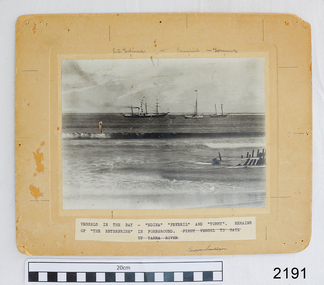
Photograph - Vessels, Sailing Ships, Vessels in the bay, 1890's
The photograph, taken in the 1890s, shows sailing ships and a wreck in Lady Bay, Warrnambool. Lady Bay was once a very busy port of trade in Warrnambool and was also called the Port of Warrnambool or Warrnambool Harbour. ENTERPRISE (1847-1850) NOTE: The “Enterprise” wrecked in 1850 in Warrnambool should not be confused with John Pascoe Faulkner’s ‘Enterprise’, which was wrecked in NSW in 1847. The 58-ton schooner Enterprise was built by David Hay in Waiheke, New Zealand in 1847 and registered by owners John Watson and Edward Byam in Melbourne, Australia. She was a single-deck sailing ship with two masts, used for carrying cargo such as local agricultural produce and general commodities between Melbourne and other colonial ports. On September 14th, 1850 the Enterprise had sailed from Melbourne under the control of the ship’s Master, James Gardiner Caught, and was moored in at the Tramway Jetty in Lady Bay, laden with wheat and potatoes. The vessel rode out a south-easterly gale but eventually dragged anchor and was beached, bow first and then broadside. Buckwall, a local indigenous man, braved the heavy surf and reached the stricken vessel with a rescue line, saving all five crew on board. There were no passengers on board. The Enterprise wreck was in an area called Tramway Jetty in Lady Bay. Since then the area has become the location of Lady Bay Hotel and now, in 2019, it is in the grounds of the Deep Blue Apartments. In fact, with the constantly changing coastline through built-up sand, the wreck site is now apparently under the No 2 Caravan Park on Pertobe Road, perhaps 150 metres from the high tide. Its location was found by Ian McKiggan (leader of the various searches in the 1980s for the legendary Mahogany Ship). The Warrnambool Wreck Enterprise is listed on the Victorian Heritage Database VHR S238. DIFFERENTIATING the New Zealand Schooner “Enterprise” from John Fawkner’s “Enterprize“ Dr Murray Johns, Melbourne, says in his article The Mahogany Ship Story, “…the Enterprise, wrecked in Lady Bay, Warrnambool in 1850 ... was soon covered by sand but was exposed again after several storms in 1887. “Samples of timber were then cut from the wreck, which would then have been buried for 37 years. In November 1887 the Warrnambool Standard reported that “the timber looks sound and hard, a penknife scarcely making any impression.” “For many years there was confusion about the identity of that ship in Lady Bay. Most people believed it was the wreck of John Pascoe Fawkner’s Enterprize, which had sailed from Tasmania to Victoria bringing the pioneer settlers to Melbourne in 1835. “In fact, as I documented in 1985, the Warrnambool wreck was of an entirely different ship, also called Enterprize [Enterprise], but built in New Zealand in 1847. Fawkner’s ship had already been sold to Captain Sullivan in 1845 and was wrecked on the Richmond Pier in northern New South Wales early in 1847. “In 1985 a piece of timber from the local Enterprise, which had been kept at the Warrnambool Museum since 1892, was identified histologically as a New Zealand timber, not Tasmanian timber such as blue gum, from which Fawkner’s Enterprize would have been built in 1830. This confirmed the identity of the Warrnambool Enterprize.”[Dr. M.W. Johns later wrote an article called “The Schooner Enterprise: A Final Word on a Historic Wreck.”] ABOUT THE S S EDINA The three-masted iron screw steamer SS Edina was built in Glasgow, Scotland, in 1854 by Barclay and Curle. She was adorned with the figurehead of the ‘fair maid of Judea’. The many years of service made SS Edina famous worldwide as the longest-serving screw steamer. (The term screw steamer comes from being driven by a single propeller, sometimes called a screw, driven by a steam engine.) SS Edina’s interesting history includes English Chanel runs, serving in the Crimean Ware carrying ammunition, horses and stores to the Black Sea, and further service in the American Civil War and later, serving in the western district of Victoria as well as in Queensland and carried gold, currency and gold prospectors Australia to New Zealand. SS Edina had the privilege of being an escort vessel to H.R.H. the Duke of Edinburgh during his visit to Australia in 1867. In March 1863 SS Edina arrived in Port Phillip Bay, Melbourne and was bought by Stephen Henty, of Portland fame, to work the cargo and passenger run from Melbourne – Warrnambool – Port Fairy - Portland. After a short time of working the run from Australia to New Zealand, with passengers and cargo that included gold and currency, she returned to her Melbourne - Warrnambool – Port Fairy run, with cargo including bales of wool produced in the western district of Victoria. The Warrnambool Steam Packet Company purchased SS Edina in 1867; she was now commanded by Captain John Thompson and Chief Engineer John Davies. She survived several mishaps at sea, had a complete service and overhaul and several changes of commanders. In 1870 SS Edina was in Lady Bay, Warrnambool, when a gale sprung up and caused a collision with the iron screw steamer SS Dandenong. SS Edina’s figurehead was broken into pieces and it was not ever replaced. SS Edina was re-fitted in 1870 and was then used as a coastal trader in Queensland for a period. She was then brought to Melbourne to carry cargo and passengers between Melbourne and Geelong and performed this service from 1880-1938. During this time (1917) she was again refitted with a new mast, funnel, bridge and promenade deck, altering her appearance. In 1938, after more collisions, SS Edina was taken out of service. However, she was later renamed Dinah and used as a ‘lighter’ (a vessel without an engine or superstructure) to be towed and carry wool and general cargo between Melbourne and Geelong. In 1957, after 104 years, the SS Edina was broken up at Footscray, Melbourne. Remains of SS Edina’s hull can be found in the Maribyrnong River, Port Phillip Bay. This photograph is significant for its association with the screw steamer SS Edina, heritage listed on the Victorian Heritage Database VHR S199. She had endeared herself to the people of Port Phillip Bay as a passenger ferry, part of their history and culture. She played a significant role in the Crimean War, the American Civil War and the gold rush in New Zealand. She also served western Victoria for many years in her cargo and passenger runs. The SS Edina is famous for being the longest-serving screw steamer in the world. After spending her first nine years overseas she arrived in Melbourne and her work included running the essential service of transporting cargo and passengers between Melbourne and the western Victoria ports of Warrnambool, Port Fairy and Portland. The SS Edina was purchased in the late 1860s by the local Warrnambool business, the Warrnambool Steam Packet Co. and continued trading from there as part of the local business community. Her original ‘fair maid of Judea’ figurehead was broken to pieces in a collision with another vessel (the SS Dandenong) in a gale off Warrnambool, Victoria, in 1870. The photograph is significant for its association wreck of the Victorian Heritage Listed schooner Enterprise, VHR S238, being a New Zealand-built but Australian-owned coastal trader. The wreck was also significant for its association with the local indigenous hero, Buckawall, who saved the lives of the five crew on board. Photograph "Vessels in the Bay". Black and white photograph of several vessels in Lady Bay, Warrnambool, including some small vessels and "S.S. Edina", the "Peveril" and "Tommy", plus the remains of the wrecked vessel "Enterprise" in the foreground. Photograph is mounted on beige card with label describing the vessels, plus pencilled vessel names. There are several pin holes in each corner of the photograph. Typed label under the photograph “VESSELS IN THE BAY – “EDINA” “PEREVIL” AND “TOMMY”. / REMAINS OF “THE ENTERPRISE” IN FOREGROUND. (Also crossed out on the label “FIRST VESSEL TO SAIL UP YARRA RIVER). In pencil script above the vessels on the photograph “S.S. Edina”, “Peveril” “Tommy”. On the reverse is a printed sticker with “F-Ph 59/2 74”, red felt-tip pen “88”, green pen script repeating the text that is under the photograph on the front.flagstaff hill, warrnambool, shipwrecked-coast, flagstaff-hill, flagstaff-hill-maritime-museum, maritime-museum, shipwreck-coast, flagstaff-hill-maritime-village, enterprize, port of warrnambool, warrnambool harbour, peveril, tommy, ss edina, lighter dinah, warrnambool steam packet company, lady bay, pleasure steamer, edina, trade, travel, screw ship, coastal trader, cargo, victoria, buckawall, indigenous rescue, indigenous hero -
 Stawell Historical Society Inc
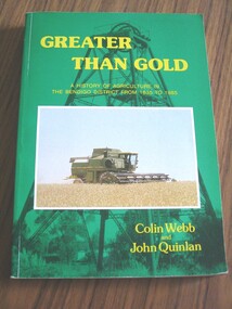
Book, Colin Webb & John Quinlan, Greater Than Gold 1985, A History of Agriculture in the Bendigo District from 1835 -1985 by Colin Webb & John Quinlan, 1985
History of Agriculture in the Bendigo District from 1835 - 1985.Green Card Cover, B/W. Photo of Poppet Head. Colour Photo of a harvester in wheat field.Greater Than Gold A History of Agriculture in the Bendigo District from 1835 to 1985 Colin Webb and John Quinlanbendigo, stawell farming -
 Arapiles Historical Society
Container - Roy SCHMIDT Collection - Cotton Flour Bags (3)
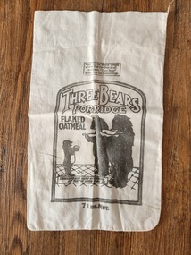
[1] Three Bears Porridge Flaked Oatmeal Bag: This textile bag originates from Canadian Cereal Mills Ltd., which marketed "Three Bears" flaked oatmeal. Popular in the early 1900s to mid-century, this product combined functional packaging with a child-friendly incentive — a cut-out cloth doll. The practice of printing toys, games, or clothing patterns on flour or oat sacks was a common marketing strategy, encouraging reuse and appealing to families during times when thrift and creativity were essential, especially during the Depression and wartime years. The Three Bears brand played off the enduring popularity of children’s nursery tales, while the doll encouraged children (and parents) to reuse packaging creatively. This object captures a unique intersection of food marketing, household resourcefulness, and early 20th-century domestic life. [2] Mammy Self-Raising Flour Bag: This item is a mid-20th-century Australian flour bag, branded “Mammy Oven Puff”, produced by A. Mammy Products Pty Ltd in West Footscray, Victoria. The use of the name "Mammy" and the caricatured illustration draws on a now widely recognised and offensive racial stereotype originating from American minstrel culture, commonly used in product branding in the early-to-mid 20th century. While the bag reflects a specific period in Australian domestic and commercial packaging history, it also exemplifies racially insensitive advertising that would be considered inappropriate and harmful by today’s standards. Such items are preserved today in museum collections to help document past social attitudes, consumer culture, and the evolution of racial representation in advertising. [3] Bandung Blue Triangle Brand Flour Bag: This bag represents a mid-20th-century Australian flour export product, particularly aimed at international markets such as Indonesia (as indicated by "Bandung"). The “Blue Triangle Brand” was likely a registered trademark used by a Melbourne-based flour mill engaged in both local and overseas trade. The use of durable cloth bags for bulk flour was common prior to the widespread adoption of paper and plastic packaging. These bags were often reused domestically for household textiles, clothing patterns, or storage. The export reference (Bandung) underscores Australia's historical agricultural trade ties with Southeast Asia, especially in wheat and flour exports. – Roy SCHMIDT resided with his siblings Mabel and Jack at ‘Parklands’ 85 Lake Avenue Natimuk home of Heinrich Friederick ‘Heiny’ & Minna Christina SUDHOLZ nee LANGE and their children Louis, Sophie, Alma, Lena (Roy's Mother), Florence 'Florrie' and Edward ‘Ted’.[1] Three Bears Porridge Flaked Oatmeal Bag: A vintage cloth oatmeal bag printed with black ink on both sides. One side is branded with "Three Bears Porridge – Flaked Oatmeal", showing an image of three bears behind a gate, referencing the well-known “Goldilocks and the Three Bears” fairytale. The opposite side features a printed cut-out doll design, showing a young girl with curly hair holding a bouquet of flowers, intended to be sewn into a stuffed toy. Instructions note that the reverse side (the doll’s back) could be obtained from a second bag. The design combines product branding with a promotional activity for children, typical of early- to mid-20th-century grocery packaging aimed at reuse. [2] Mammy Self-Raising Flour Bag: A small vintage cloth flour bag with printed branding in faded red, blue, and black inks. The front of the bag features a central image of a caricatured smiling African American woman wearing a headscarf. The text is unevenly faded but legible in parts. The bag has a rectangular shape with an open top edge and signs of previous use, including creasing and some fraying at the corners. [3] Bandung Blue Triangle Brand Flour Bag: A large, rectangular vintage cloth flour bag made of cream-coloured calico or cotton. The front of the bag is printed in bold blue ink with branding and export information. It prominently features a large triangular logo reading “Blue Triangle Brand” and numerous lines of text in block and stylised fonts. The bag is open at the top with frayed edges, suggesting it was once machine-stitched shut and later opened.[1] Three Bears Porridge Flaked Oatmeal Bag: Front side (branding side): "THREE BEARS Porridge – FLAKED OATMEAL" "7 Lbs. Net." “Packed and guaranteed by Canadian Cereal Mills Ltd., Toronto” Reverse side (doll pattern): "This is the Front for Three Bears Cut-out Doll" "In order to complete this Doll it will be necessary to obtain the Back Design from another Bag of Three Bears Rolled Oats or Oatmeal." [2] Mammy Self-Raising Flour Bag: Main product name: “MAMMY OVEN PUFF SELF-RAISING FLOUR” Additional text: “The Only Creamed Flour” “Prepared with phosphate aerator” “A. MAMMY PRODUCTS PTY. LTD., Sunshine Rd., West Footscray. Phone: FW 7321” “7 LBS. NET” (near top edge, very faded) [3] Bandung Blue Triangle Brand Flour Bag: The bag is printed with the following: “10270” “G.W.C | H.L” “BANDUNG” “BEST AUSTRALIAN” “BLUE TRIANGLE BRAND” (inside the triangle logo) “GROWER & GRINDERS” (curved around the logo) “Patent Roller” “MELBOURNE” “FLOUR” “50 LBS. GROSS WHEN PACKED” These inscriptions indicate that this flour bag was manufactured in Melbourne, Australia, and was likely exported to Bandung, Indonesia.farm equipment, flour, milling, oats -
 Bendigo Historical Society Inc.
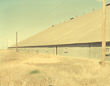
Slide - Mouat Crawford Collection: Farming Life in the Wimmera
Wheat terminal at Murtoa, known as the stick shed Markings: Murtoa(SIC) Bulk Wheat Terminal. The Stick Shed. Used as a teaching aid.PERUTZagriculture, farm, crop storage, wimmera, wheat silo, stick shed, murtoa, mouat crawford collection -
 Bendigo Historical Society Inc.
Slide - Mouat Crawford Collection: Farming Life in the Wimmera, c1960s
... AGRICULTURE Farm Crop wheat wimmera sheaves mouat crawford ...Cutting the crop ready to make sheaths. Used as a teaching aid.ILFORDagriculture, farm, crop, wheat, wimmera, sheaves, mouat crawford collection -
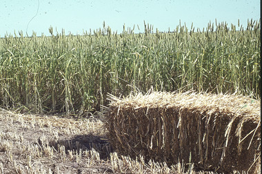 Bendigo Historical Society Inc.
Slide - Mouat Crawford Collection: Farming Life in the Wimmera, c1960s
Baled Hay sitting in from of the remainder of un cropped crop. Markings: Wheat Crop with Baled hay. Used as a teaching aid.Agfacoloragriculture, farm, crop, wimmera, baled wheat, mouat crawford collection -
 Bendigo Historical Society Inc.
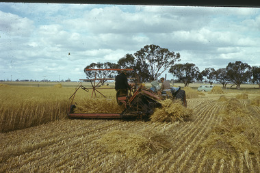
Slide - Mouat Crawford Collection: Farming Life in the Wimmera, c1960s
... AGRICULTURE Farm Wheat crop harvesting header tractor mouat ...Harvesting wheat crop is written on white tape on bottom of slide. Used as a teaching aid.Agfacoloragriculture, farm, wheat crop, harvesting header, tractor, mouat crawfored collection -
 Bendigo Historical Society Inc.
Slide - Mouat Crawford Collection: Farming Life in the Wimmera, c1960s
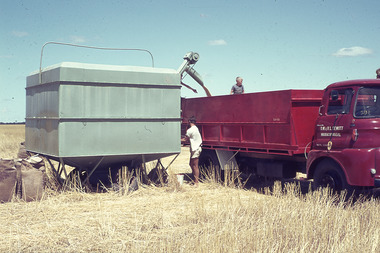
Filling the truck with wheat from the field bin. Name on door of truck is D W L V Hewitt, Warracknabeal. A man in the back of the truck and one standing on the ground at the controls of the field bin. Markings: Wheat - farm bulk field bin to truck. Used as a teaching aid.Agfacoloragriculture, farm, crop, warracknabeal, wimmera, truck wheat, hewitt, mouat crawford collection -
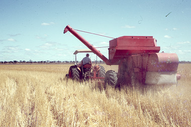
 Bendigo Historical Society Inc.
Slide - Mouat Crawford Collection: Farming Life in the Wimmera, c1960s
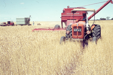
... AGRICULTURE Farm Wheat crop tractor header harvester ...Tractor pulling a Massey Ferguson header, field bin, truck and station wagon in background, also a lady. Markings:White tape on bottom of slide reads; Wheat header working. Used as a teaching aid.Agfacoloragriculture, farm, wheat crop, tractor, header, harvester, wimmera, mouat crawford collelction -
 Bendigo Historical Society Inc.
Slide - Mouat Crawford Collection: Farming Life in the Wimmera, c1960s
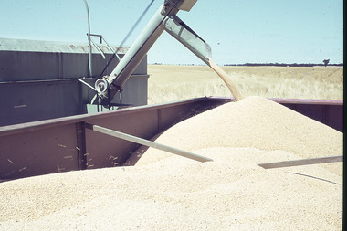
... AGRICULTURE Farm Crop wimmera wheat truck mouat crawford ...Shows wheat from the field bin being transferred into the back of the truck for cartage. Markings: Wheat from field bin into truck. Used as a teaching aid.Agfacoloragriculture, farm, crop, wimmera, wheat truck, mouat crawford collection