Showing 123 items
matching whitelaw-monier
-
 Bendigo Historical Society Inc.
Negative - GERMAN HERITAGE SOCIETY COLLECTION: NEGATIVES - BOLDT
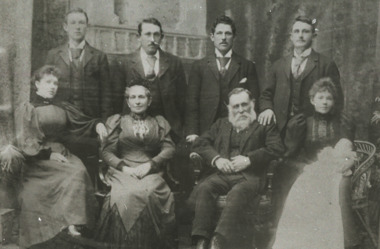
Red and blue negatives folder with a Konica camera on the front and Boldt written on the front in texta. It contains negatives of the Boldt Family. Also in the folder is a blue sheet of writing paper with the names of the people in the negatives. They are: 1 - 3 group back row L - R, Ernst, Carl, Wilhelm, Edward. Front row Hermina, Elise, Albert, d in law Charlotte & baby Florence. 4. Albert Boldt (1894). 5. Hermann & Marie lived in Wilhelmslust (Germany). 6. Herman & Marie. 7. Eugenie & August Boldt & Lilli Weich (adopted daughter). 8. Edward Boldt killed under Monier Bridge. 9. Wilhelm Boldt in front of present house with Tip Top stallion. 10. Wilhelm Boldt in front with axe (wood carting). 11. Elise wife of Albert Boldt. 12. Monier bridge (collapse due to bad concreting) Edward Boldt under the rubble (app. 1900) near Gas Works, Bendigo. 13. Carl Jess, school teacher Rays Hill State School scholars. 14. Teachers & Headmaster, Violet St. State School, Bendigo. 15. Elise Boldt (70 years old). 16. Johanna Boldt. negative, bendigo, german heritage society, german heritage society collection - negatives - boldt, ernst, carl, wilhelm, edward, hermina, elise, albert boldt, charlotte, florence, marie, eugenie & august boldt, lilli weich, edward boldt, wilhelm boldt, elise boldt, monier bridge (king's bridge near gas works), gas works bendigo), carl jess, rais hill state school, violet st state school, johanna boldt -
 Bendigo Historical Society Inc.
Map - K. K. MINE - TRANSVERSE SECTION K. K. MINE
Transverse Section of the K. K. Mine on the Hustler's Line of Reefs, Bulletin No 33, Plate No XXXII. Map shows the different levels and their depth. Also, the different types of stone encountered and geological features such as spurs and faults. Has drawing of the poppet legs at the top of the shaft and sill of shaft 773.56 ft above sea level. Map has Geological Survey of Victoria crest and signed by H S Whitelaw, Underground Survey Office Bendigo, September 1913. miners, fortuna hustler's mine, transverse section of k. k. mine, hustler's line of reefs, geological survey of victoria, h s whitelaw -
 Bendigo Historical Society Inc.
Map - HUSTLER'S REEF MINE - EAST & WEST CROSS-CUTS, NORTH & SOUTH OF SHAFT
East & West Crosscuts, North & South of Shaft, Hustler's Reef Mine Bulletin No 33, Plate No XIX. Map shows main shaft and smaller drawing of section with different stone encountered. Also gives location in relation to the shaft, e. g. 225'E & 150'S of Shaft. Reference diagram to show the different stone and features encountered. Geological Survey of Victoria emblem. Signed by H A Whitelaw, Underground Survey Office Bendigo, September 1913. mining, parish map, hustler's reef mine, east & west cross-cuts north & south of shaft, geological survey of victoria, h a whitelaw, underground survey office bendigo -
 Bendigo Historical Society Inc.
Map - HUSTLER'S REEF & HUSTLER'S REEF NO 1 MINES - LONGITUDINAL SECTION OF THE HUSTLER'S REEF & HUSTLER'S
Longitudinal Section of the Hustler's Reef & Hustler's Reef No 1 Mines on the Hustler's Line of Reef. Bulletin No 33, Plate No XX. Note - Plates 4, 8, 13, 20, 26 & 31 form a Longitudinal Section from Fortuna Hustler's to Hustler's Consols Mine. Geological Survey of Victoria emblem. Signed by H A Whitelaw, Underground Survey Office Bendigo, September 1913. Shows the two shafts with their levels and depths. Also shows geographical features and yields of gold and amalgam per ton. .mining, parish map, hustler's reef & hustler's reef no 1 mines, geographical survey of victoria, underground survey office bendigo, h a whitelaw -
 Bendigo Historical Society Inc.
Map - HUSTLER'S REEF MINE - TRANSVERSE SECTION OF THE HUSTLER'S REEF MINE
Transverse Section of the Hustler's Reef Mine on the Hustler's Line of Reefs. Bulletin No 33, Plate No XVIII. Shows cross-cuts and their depth, different types of stone and geological features encountered. Drawing of poppet legs at the surface and Sill of Shaft 756.39 ft above Sea Level. Reference Table shows key to the different stone and geographical features encountered. Geographical Survey of Victoria. Signed by H A Whitelaw, Underground Survey Office, Bendigo, September 1913. Thompson's Reef is also mentioned on the map. mining, hustler's reef mine, transverse section of the hustler's reef mine, geological survey of victoria, h a whitelaw, underground survey office bendigo, thompson's reef. -
 Bendigo Historical Society Inc.
Map - HUSTLER'S ROYAL RESERVE NO 2 CO - TRANSVERSE SECTION OF THE HUSTLER'S ROYAL RESERVE NO 2 CO
Transverse Section of the Hustler's Royal Reserve No 2 Co Mine on the Hustler's Line of Reef Bendigo, Bulletin No 33, Plate No VII. Section shows the poppet legs and the sill of Shaft at 707.65 ft above sea level, depth of levels, stone encountered and geological features. Geological Survey of Victoria emblem. H. Herman Director, W. Dickson Secretary of Mines and The Hon. J. Drysdale Brown MLC, Minister of Mines. Signed by H S Whitelaw, Underground Survey Office Bendigo, September 1913. mining, parish map, hustler's royal reserve no 2 co, h s whitelaw, undergrou;nd survey office bendigo, geological survey of victoria, h herman, w dickson, the hon. j drysdale brown mlc -
 Bendigo Historical Society Inc.
Map - GREAT EXTENDED HUSTLER'S MINE - PLAN OF THE GREAT EXTENDED HUSTLER'S MINE
Plan of the Great Extended Hustler's Mine on the Hustler's Line of Reefs, Bendigo. Bulletin No 33, Plate No X. Lease No 7382. Plan has map of streets. Mine was located in the block bounded by Langston and Anderson Streets and was between the Hustler's Anticline at Surface and the Lightning Hill Anticline at Surface. Latham & Watson's Shaft is also mentioned. Levels are numbered and a table shows the Levels and their Depths. Geological Survey of Victoria. Signed by H A Whitelaw, Underground Survey Office, Bendigo, September 1913. This item has not been scanned or photographed.mining, parish map, great extended hustler's mine, hustler's line of reefs, mining lease no 7382, geological survey of victoria, underground survey office bendigo, h a whitelaw, latham & watson's shaft -
 Bendigo Historical Society Inc.
Map - FORTUNA HUSTLER'S MINE - LONGITUDINAL SECTION OF THE FORTUNA HUSTLER'S MINE
Longitudinal Section of the Fortuna Hustler's Mine on the Hustler's Line of Reef, Bendigo. Bulletin No 33, Plate No IV. Shows poppet legs at the surface level, Datum Line 750 feet above Sea Level, levels and their depths, the amount of gold per ton and some geographical features. Geological Survey of Victoria emblem and signed by H A Whitelaw, Underground Survey Office, Bendigo. Note - Plates 4, 8, 13, 20, 26 & 31 form a Longitudinal Section from Fortuna Hustler's to Hustler's Consols Mine. mining, parish map, fortuna hustler's mine, longitudinal section of the fortuna hustler's mine, geological survey of victoria, h a whitelaw, underground survey office bendigo, hustler's line of reef, hustler's consols mine -
 Bendigo Historical Society Inc.
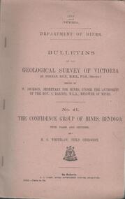
Book - MINING REPORTS - THE CONFIDENCE GROUP OF MINES BULLETIN NO 41
Light brown covered booklet 'Bulletins of the Geological Survey of Victoria issued by W Dickson, Secretary for Mines, Under the Authority of the Hon. S Barnes M L A Minister of Mines. No 41 The Confidence Group of Mines, Bendigo with Plans and Sections by H S Whitelaw, Field Geologist, dated 1918. Mines mentioned are: Confidence Extended Mine, Confidence Tribute Company and the Central Windmill Hill Mine. Mentioned in the report are crushings and gold yield, details of levels, names of leases along the reef. Extracts from Mine Manager's Half-yearly Reports, 1878-1915 of tons crushed and gold yield. Plans and sections of the Confidence Extended Mine on the Garden Gully Line of Reefs are: Plate I General Plan of All Levels, Plans of Levels Plate No II, Plans of Levels Plate No III, Transverse Section Plate No IV, Longitudinal Section Plate No V, and Central Windmill Hill Mine Transverse Section Plate No VI. Plates signed by H S Whitelaw 17 & 18/6/16 and 20/7/16. Booklet if part of the Albert Richardson Collection. book, bendigo, mining reports, mining reports, the confidence group of mines bulletin no 41, confidence extended mine, confidence tribute company, central windmill hill mine, department of mines, bulletins of the geological survey of victoria, w dickson, the hon s barnes, h s whitelaw, h j green, mr robert eddy, mr w h cundy, j foster, c j thompson -
 Bendigo Historical Society Inc.
Map - HUSTLER'S REEF & HUSTLER'S REEF NO 1 MINES - PLAN OF THE HUSTLER'S REEF & HUSTLER'S REEF NO 1 MINES
Plan of the Hustler's Reef & Hustler's Reef No 1 Mines on the Hustler's Line of Reefs Bulletin No 33, Plate No XV. Plan shows the two mines with depth of levels, geological features and levels in relation to the shaft. Geological Survey of Victoria emblem and signed by H A Whitelaw, Underground Survey Office Bendigo, September 1913. Note - The Lease Boundaries shown on this plan are only in their approximate relative positions to Nos 13, Intermediate and 14 Levels of the Hustler's Reef No 1 workings, and Nos 15, 16 and 17 Levels of the Hustler's Reef workings.mining, parish map, hustler's reef & hustler's reef no 1 mines, geological survey of victoria, underground survey office bendigo, h a whitelaw, hustler's line of reefs -
 Bendigo Historical Society Inc.
Map - HUSTLER'S REEF NO 1 MINE - TRANSVERSE SECTION OF THE HUSTLER'S REEF NO 1 MINE
Map of a transverse Section of the Hustler's Reef No 1 Mine on the hustler's Line of Reefs Bulletin No 33, Plate No XXI. Map shows poppet legs at 801.07 feet above Sea Level and drawing of shaft with the different levels. Also shown are geological features and stone encountered. Geological Survey of Victoria emblem H Herman, Director, W Dickson, Secretary of Mines and The Hon. J. Drysdale Brown MLC Minister of Mines. Signed by H S Whitelaw, Underground Survey Office Bendigo, September 1913. This item has not been scanned or photographed.mining, parish map, hustler's reef no 1 mine, hustler's line of reefs, geological survey of victoria, underground survey office bendigo, h s whitelaw, h herman, w dickson, the hon j drysdale brown -
 Bendigo Historical Society Inc.
Map - HUSTLER'S ROYAL RESERVE NO 2 (PARK SHAFT.) - TRANSVERSE SECTION OF THE HUSTLER'S ROYAL RESERVE NO 2
Transverse section of the Hustler's Royal Reserve, No 2 (Park Shaft.) on the Hustler's Line of Reef. Bulletin No 33, Plate No IX. Section shows poppet legs and sill of shaft at 755.70 ft above sea level, depth of levels, type of stone encountered including lava and geological features. Geological Survey of Victoria emblem and beneath it H. Herman, Director, W. Dickson, Secretary of Mines and The Hon. J. Drysdale Brown MLC Minister of Mines and signed by H S Whitelaw, Underground Survey Office, Bendigo September 1913.mining, parish map, hustler's royal reserve no 2 (park shaft.), h s whitelaw, underground survey office bendigo, geological survey of victoria, h herman, w dickson, the hon j drysdale brown mlc, hustler's line of reef -
 Melbourne Tram Museum
Document - Memorandum, "Physical Culture Display by State School Children at Melbourne C. Ground - Monday 22 October, 1934", 16/10/1934 12:00:00 AM
Memorandum - three typed sheets (8"x10.5") - titled "Physical Culture Display by State School Children at Melbourne C. Ground - Monday 22 October, 1934" from DJ Davidson, District Traffic Superintendent S.S. to Mr Davis, Hawthorn, Mr Bradley, Glenhuntly and Mr Jones, Malvern. Memo dated 16 October and specifies trams required for event at MCG. Also paper pinned to front with inscription: "Physical Culture Display MCG, Mon 22nd Oct 1934" written in red pencil (Mon 22nd crossed out) and "Tues 23rd" and "Run Tuesday 23rd" written in black pencil."Physical Culture Display MCG, Mon 22 Oct 1934" written in red pencil and "Tues 23rd" and "Run Tuesday 23rd" written in black pencil on attached note, "Copy to Senior Insp Whitelaw & Conkey" written in black pencil on Hawthorn memo, "Copy to Ghtly Insp" written in black pencil on Glenhuntly memo, "Copy to Senior Insp Brown" written in black pencil on Malvern memotrams, tramways, instructions, events -
 Bendigo Historical Society Inc.
Map - RAYWOOD GOLD FIELD MAP, 1902
Map. Raywood Gold Field Map. Linen backed map of Raywood and Neilborough Township and surrounds showing the location of varying underground workings. Surveyed by H S Whitelaw 1/6/02. It shows underground workings from The Perseverance Party and moreshed and Party and underground workings on the Old Pioneer Reef. Mentions the Parish of Yallook, Parish of Neilborough, Yarraberb, Mushroom Flat, Murray Valley Plain, Eaglehawk and Kerang Railway, Green Hill, Doughboy, Redmond's Gully, Pickpocket Lead, Raywood Lead, Inglewood Lead, Shaw's Road, Nuggety Shaft, Barkly Shaft, Maori Bendmap, gold field map, raywood gold field map, neilborough, h s whitelaw, geological survey of victoria bulletin no 12 plate 11 -
Bendigo Historical Society Inc.
Document - Regional Forum Report for CoB by RASMAC, Michele Matthews Collection, 8.6.1999
The Sir John Quick Committee was formed in 1991 to commemorate the achievements of Sir John Quick who played a prominent role in the federation of Australia. The Committee aimed to raise awareness of the contribution of Sir John Quick and to ensure that he was recognized for the part he played.Nine page report for the City of Bendigo dated 8.6.1999 issued by Jenny Whitelaw, Senior Advisor. The report covers the content and recommendations following a regional forum and workshop sessions conducted through the Regional and Specialist Museums Advisory Committee (RASMAC) Leadership program, held on May 24 and 25 1999. "The purpose of this forum was to identify the major issues for consideration in planning a museum concept for Bendigo." Includes List of attendees. Issues of importance and recommendations to the City of Greater bendigo. Suggested themes for Bendigo Museum of Victoria. Recommendations for consideration with regard to: City of Greater Bendigo proposal to establish a museum.sir john quick committee, bendigo museum of victoria, rasmac, regional and specialist museums advisory committee, jenny whitelaw -
 Federation University Historical Collection
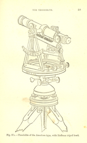
Book, Bennett H. Brough, A treatise on Mine-Surveying, 1904
The author, Bennett H. Brough was an associate of theRoyal School of Mines, a member of the COuncil of the Institution of Mining Engineers, a fellow of the geological society and of the Institute of Chemistry, a member of the Mining Institute of Cornwall, and a former instructor of mine-surveying at the Royal School of MinesRed had covered book 372 pages - part of Griffin's Mining Series. Contents include general explanatinos of surveying, an historical sketch, mineral deposits, mining terms, measures of length, measurement distances, the chain, rods, steel bands, measuring wheel, Miner's Dial, Magnetic needle, Fixed needle, German Dial, theodolite, traversing underground. Surface-surveys. plotting the survey, calculation of area, leveling, Telescope, Setting out, Mine-Surveying Problems, Mine Plans, Photographic Surveying, examination Surveying. Illustrations include: Whitelaw's Dial (Fig 22), Theodolite of the American Type with Hoffman tripod head, (fig 37a)mining, surveying, miner's dial, chain, survey, theodolite, scientific instruments -
 Bendigo Historical Society Inc.
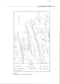
Document - CAROL HOLSWORTH COLLECTION: GEOLOGICAL REPORT BENDIGO
Four page document, not sequential. Front page: structural trends, major faults and folds in the Bendigo area are depicted in a diagram. Fault lines and folds include the Leichardt Fault, the Break O'Day Fault, Sebastian Fault, Whitelaw Fault, the Yankee Creek Fault and the Fosterville Fault. Aecond page shows the typical reef forms on the Bendigo goldfield (Willman 1988) in a diagram. The Sebastian goldfield is described, with its four lines of reef, the Eureka, Gaskill's, Frederick the Great and Gamboni. Third page describes the White Hills gravels. Fourth page is a table showing thel biostratigraphic zonation of the Ordovician bedrock based on key graptolite forms and assemblages.bendigo, mining, geological bulletin -
 Melbourne Tram Museum
Document - Specification, Melbourne & Metropolitan Tramways Board (MMTB), "specifications - MMTB various", 1922 to 1925
See image 2085i4 for tender re brake blocks detailing the type of cast iron and the Brinell hardness.Demonstrates MMTB tender documents of 1923.Manila colour file marked "Specifications" containing 25 different specifications of the MMTB 1922 to 1925. Not all dated, generally foolscap sheets either pinned or stapled. Dated Tender No. For supply of: 30/6/1925 157 Steel castings Not dated Ballast Hopper trucks 1923 Steelwork for electric and cable tramway crossings Pamphlet Monier Pipes and box culverts Pamphlet Monier – septic tanks and aerators Not dated 229 Purchase of removal of cottages 101 to 107 Bouverie St Carlton Not dated Side tipping ballast trucks 18/7/1923 226 Brake shoes - see pdf file for a full scan 18/7/1923 222 Steel tramway tyres 18/7/1923 220 Concrete Mixing Plants Not dated 219 Dressed wooden poles 9/5/1923 215 Bricks 19/4/1923 214 Reinforced Concrete fencing posts 20/3/1923 213 Tramway steel wire ropes 28/3/1923 212 Painting exterior of 673 Bourke St Melbourne Not dated 210 Alterations to offices at Rathdowne St depot Not dated 202 80lb steel rails and fishplates 5/1/1923 198 GE201 Motors 6/12/1922 197 Hydraulic pit jacks 6/12/1922 195 Supply of Low tension feeder cable Not dated 194 Supply of high tension cable 4/12/1922 188 Supply of hard drawn trolley wire 6/11/1922 186 Dressed wooden poles 20/11/1922 182 Steel Poles 20/12/1922 171 Erection and completion of new car depot Glen Huntly Roadtrams, tramways, mmtb, tenders, specification, trackwork, motors, cables, poles, ballast wagons, glenhuntly tram depot, brake blocks -
 Bendigo Historical Society Inc.
Map - HUSTLER'S REEF & HUSTLER'S REEF NO 1 MINES - PLAN OF THE HUSTLER'S REEF & HUSTLER'S REEF NO 1 MINES
Plan of the Hustler's Reef & Hustler's Reef No 1 Mines on the Hustler's Line of Reefs, Bendigo Bulletin No 33, Plate No XIV. No 8 connecting No 10 (Hustler's Reef), No 11 connecting No 13 (Hustler's Reef), No 13 (Hustler's Reef No 1) connecting No 15 (Hustler's Reef) and No 10 Hustler's Reef No 1 rise to Comet Mine. Map shows different levels in relation to the two shafts, the lines of the Hustler's Line of Reefs and the Lightning Hill Line of Reefs, the approximate Boundary of Lease and the Comet Co., the adjoining lease. Table on the left shows the levels and their depths of the two mines. Signed by H A Whitelaw, Underground Survey Office, Bendigo, September 1913. Geological Survey of Victoria emblem. mining, parish map, hustler's reef & hustler's reef no 1 mines, hustler's line of reefs lightning hill line of reefs, comet co., h a whitelaw, underground survey office bendigo, geological survey of victoria -
 Bendigo Historical Society Inc.
Map - GREAT EXTENDED HUSTLER'S MINE - TRANSVERSE SECTION OF THE GREAT EXTENDED HUSTLER'S MINE
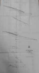
Transverse Section of the Great Extended Hustler's Mine on the Hustler's Line of Reef. Bulletin No 33, Plate No XII. Shows Poppet legs at the surface and Sill of Shaft at 788.99 feet above Sea Level, Cross Cuts and their depths, stone and geographical features encountered and their references and a number of enlarged drawing of sections of the crosscuts, Geological Survey of Victoria emblem and signed by H A Whitelaw, Underground Survey Office Bendigo, September 1913. The depths of crosscuts to No 21 were taken from plans of surveys by Mr. Walker and Mr. Craven, noted under Reference. Another note: This Saddle Reef is sketched from Mr. Walker's plan. Dividends amounting to 360,000 pounds were obtained from it. mining, parish map, great extended hustler's mine, transverse section of the great extended hustler's mine, old shaft, mr walker, mr craven, geological survey of victoria, underground survey office bendigo, h a whitelaw -
 Bendigo Historical Society Inc.
Document - Geological Survey of Victoria, Hustlers Line of Reef, Bendigo, April, 2014
Seven men were killed at the Great Extended Hustler's mine disaster on 2nd May 1914 by an explosion of dynamite occurring as the men were waiting at the plat to ascend the mine at the end of their shift. No blame was attached to anyone in the findings of the inquisition. It was unknown what caused the dynamite to explode. This document formed part of the research done at the time by Bendigo Historical Society, of the 100 years commemoration of the mine disaster, held at Hustler's Hill in 2014. Seven page photocopy of Department of Mines, Bulletin, Geological Survey of Victoria, Hustlers Line of Reef, Bendigo, No. 33 by H.S. Whitelaw. Includes plan of Hustlers Royal Reserve No. 2, (main shaft) showing location on Pall Mall, and location of Post Office and Law Courts; plan of location of Hustlers Royal Reserve No. 2 (Park Shaft) showing Jail (sic), Camp Hill State School, two 'lagoons' in between tennis court, croquet court and bowling green; a plan of the Great Extended Hustler's Shaft and two copied images of Hustler's Hill showing mining buildings, poppet heads and chimneys. Comet, K.K., Hustler's No. 1, Old Comet and United Hustler's and Redan Mines are shown in the images. great extended hustlers, goldmining, accident, quartz, mining, k.k. mine, comet mine, hustler's line of reef, old comet, united hustler's, redan -
 Bendigo Historical Society Inc.
Map - UNITED HUSTLER'S & REDAN & K. K. MINES - PLAN OF THE UNITED HUSTLER'S & REDAN & K. K. MINES
Plan of the United Hustler's & Redan & K. K. Mines Bulletin No 33 Plate No XXXI. Shows depth of levels, Probable positions of reefs and natural surface with the poppet legs at the two shafts. Sill of shaft of the K. K. Mine 773.56 ft above Sea Level and sill of shaft of the United Hustler's & Redan Mine 745.62 above Sea Level. Also mentioned is the average amount of gold obtained per ton. Note on the top of page - Plates 4, 8, 13, 20, 26 & 31 form a Longitudinal Section from Fortuna Hustler's to Hustler's Consols Mine. Geological Survey of Victoria emblem and signed by H S Whitelaw, Underground Survey Office, Bendigo, September 1913. mining, parish map, united hustler's & redan & k. k. mines, geological survey of victoria, h s whitelaw, underground survey office bendigo -
 Bendigo Historical Society Inc.
Document - HUSTLERS REEF - PLANS & SECTIONS TO ACCOMPANY BULLETIN NO 33
Pink page pasted onto cream card titled Plans and Sections to accompany Bulletin No 33. Hustler's Line of Reef, Bendigo by H S Whitelaw, by Authority: Albert J. Mullett, Government Printer, Melbourne. Plate No 1 to No 34. Mines mentioned: Fortuna Hustler's Mine, Hustler's Royal Reserve No 2 Mine, Hustler's Royal Reserve Mine Park Shaft, Great Extended Hustler's Mine, Hustler's Reef and Hustler's Reef No 1 Mines, Hustler's Reef Mine, Comet Mine, United Hustler's and Redan Mine, K. K. Mine, Hustler's Consols Mine, Fortuna Hustler's Mine. Department of Mines Geological Survey of Victoria 1914. Written on the back: Lightning Hill area to Summer Hill.document, hustlers reef, plans & sections to accompany bulletin no 33, geological survey of victoria, department of mines, hustler's line of reef, h s whitelaw, fortuna hustler's mine, hustler's royal reserve no 2 mine, hustler's royal reserve mine park shaft, great extended hustler's mine, hustler's reef mine, hustler's reef no 1 mine, comet mine, united hustler's mine, redan mine, k k mine, hustler's consols mine, fortuna hustler's mine, hustler's consols mine, albert j mullett, government printer melbourne -
 Bendigo Historical Society Inc.
Map - GREAT EXTENDED HUSTLER'S MINE - LONGITUDINAL SECTION OF THE GREAT EXTENDED HUSTLER'S MINE
Longitudinal Section of the Great Extended Hustler's Mine on the Hustler's Line of Reefs. Bulletin No 33, Plate No XIII. Map shows the Hustler's Tribute, 2 Old Shafts, Great Extended Hustler's Shaft, Latham & Watson's Shaft and Ironbark Gully. Datum Line 750 feet above Sea Level. Poppet Legs on the surface and Sill of Shaft 788.99 feet above Sea Level. Levels and their depths are shown and some geographical features. Some amounts of gold mined mentioned. Geological Survey of Victoria emblem and signed by H A Whitelaw, Underground Survey Office Bendigo, September 1913. Note - Plates 4, 8, 13,20, 26 & 31 form a Longitudinal Section from Fortuna Hustlers to Hustler's Consols Mine. mining, parish map, great extended hustler's mine, geological survey of victoria, underground survey office bendigo, h a whitelaw, hustler's tribute, old shaft, great extended hustler's shaft, latham & watson's shaft, ironbark gully -
 Melbourne Tram Museum
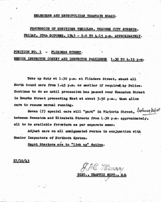
Document - Memorandum, Melbourne & Metropolitan Tramways Board (MMTB), "Procession of Munitions Vehicles, through city streets", Oct. 1943
2 copies of letter from HS Wootton, Town Clerk, City of Melbourne, titled "Arrangements in connection with "Miles of Munitions 1943" procession through city streets on Friday 29th October, 1943, in connection with Fourth Liberty War Loan". Provides details of route and assembly points with tram requirements. Dated 21 Oct 1943 8 memos from JM Harry, Dist Traffic Supt SS regarding tram arrangements to various inspectors. Memos dated 27/10/1943."Mr Harry" written in pencil on one letter. "Coburg depot" written on 2 memos. Several comments written in pencil regarding tram scheduling.trams, tramways, events, parades, world war 2, coburg depot, hanna st depot, malvern depot, hawthorn depot, camberwell depot, glenhuntly depot, victoria st, swanston st, elizabeth st, spencer st, collins st -
 Melbourne Tram Museum
Document - Memorandum, Melbourne & Metropolitan Tramways Board (MMTB), "Arrangements for Air Training Corps Parade through the city streets on Saturday 15th April 1944", Apr. 1944
"Arrangements for Air Training Corps Parade through the city streets on Saturday 15th April 1944" Letter from HS Wootton, town clerk advising of event. Several memos from JM Harry, Dist Traffic Supt SS regarding tram and bus arrangements.Notations written in pencil on memo.trams, tramways, events, parades -
 Federation University Historical Collection
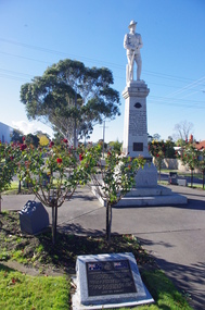
Photograph - Photograph - Colour, Alan Scarlett, Morwell War Memorial, 2015, 2015
The Morwell War Memorial Morwell War was unveiled on 06 June 1921. The Memorial was originally the level crossing between Commercial Road and Station Street (later Princes Highway). It was later moved to its present position on the Princes Highway opposite Hoyle Street. (http://www.morwellhistoricalsociety.org.au/warmemorial.htm) Names Inscribed on War Memorial – World War 1 *Killed in action * Allis G. Francis J. Pettit H. Amiet C. Graur R. L. Pryor W. * Amiet F. D. Hall J. A. Pryke R. Anderson C. Hall S. D. Rowell F. Billingsley A. H. Hare Bert Rowe C. Butters C. * Handler P. Ronald A. Q Butters R. Hogan E. J. Rintoull W. G. (D.C.M.) Brown H. H. Kleine F. W. Saddler J. Brinsmead F. S. Whitelaw A. Smith C. Collins W. Whitelaw D. Symons H. Collins J. S. F. Keegan F. Thomas L. G. Cooper H. S. Little K. Thomas R. W. Capon W. V. Lock E. * Thomson R. H. Davey R. R. Lyons C. * Tulloch J. Davey E. W. Lyons R. P. Vunell C. R. E. Davey W. R. Miller F. Vinall H. V. Davey C. E. Maher A. Wood A. Duncanson J. Maher L. Wilkins F. Dusting C. * McIntosh A. Warnett J. * Dusting H. Neal A. E. Warnetyt W. H. Derham H. * O’Donnell T. Young J. A. World War 2 – Killed in action Allen H. A. Eason L. W. McDonald D. Angus C. P. Evans H. T. Muncaster J. Bolitho H. Ferguson R. W. Murray A. M. Bolton C. R. A. Gair N. Peter T. Bowden N. J. Green D. I. A. Read L. H. M. Brudge W. G. Hewat G, A, Roy E. W. Catterick J. H. Horsefall L. Sillcock R. R. Deanne A. Johnson F. Stagg J. L. Deering C. J. King L. S. Templer R. C. Doolan W. T. Lawrence F. E. Tienery R. Dickson L. H. McArthur D. Turner R. H. Williams R. K. Vietnam War – Killed in action Adrian RichColour photograph of a life sized Australian soldier wearing a slouch hat, on top of a large raised platform. A commemorative plaque is depicted in the foreground. The front inscription of the memorial reads: "This plaque was erected in memory of those who paid the Supreme Sacrifice in the Boer War [Names] Erected by the residents of Morwell riding as a tribute to the men resident in the riding who enlisted and in memory of those who made the Supreme Sacrifice in the Great War 1914-19 [Names] This plaque is erected in memory of those who paid the Supreme Sacrifice in World War II and Korea [Names] In affectionate remembrance of A. Rich R.A.R killed in action Vietnam 1962-72"The plaque in the foreground reads" "Centenary Commemoration Plaque This plaque commemorates 100 years since the first World War commended in 1914 and Australian and New Zealand (ANZAC) troops landed at Gallipoli on 25th April, 1915. Members of the Morwell RSL Sub-Branch will always remember the sacrifices made by service personal to give us the freedom we enjoy the this day. They Shall grow not old, as we that are left grow old Age shall not weary them, nor the years condemn At the going down of the sun and in the morning We will remember them Lest We Forget."morwell, morwell war memorial, world war one, anzac centenary, gippsland -
 Eltham District Historical Society Inc
Photograph - Digital Photograph, Alan King, Monash Bridge, Hurstbridge, 23 January 2008
Monash Bridge spans the Diamond Creek at Hurstbridge. It was built in 1917 for the Shires of Heidelberg, Eltham and Whittlesea. It is considered Nillumbik Shire's finest engineered bridge and was construced by the engineering company of Sir John Monash. Covered under Heritage Overlay, Nillumbik Planning Scheme. Published: Nillumbik Now and Then / Marguerite Marshall 2008; photographs Alan King with Marguerite Marshall.; p117 Monash Bridge is considered the Shire’s finest engineered bridge and was constructed by the engineering company of that great Australian, Sir John Monash.1 The bridge spans Diamond Creek on the Hurstbridge-Arthurs Creek Road, linking Hurstbridge with Yarrambat and Arthurs Creek. Monash Bridge, also called Hurst’s Bridge, was built in 1917, by the Reinforced Concrete and Monier Pipe Construction Company Pty Ltd, for the Shires of Heidelberg, Eltham and Whittlesea. Although Monash was probably in action overseas during World War One when the bridge was designed and constructed, he evolved the basic design in the 1900s and it was a standard design for the firm. However J A Laing, a designer at the firm, was probably the designer, as his initials are on bridge drawings held by the Eltham District Historical Society.2 The bridge is an excellent early Australian example of an open spandrel reinforced concrete arch bridge and has a single span of 29 metres. It is unusual in Victoria, but similar to many reinforced concrete arch bridges in Europe and America, built from the late 19th century. In Victoria, Monash pioneered the use of reinforced concrete – then a revolutionary construction material. His company, Monash & Anderson, had the exclusive licence for the Monier patent for the system of reinforced concrete construction for Victoria and New South Wales. A well-known example of the Monier arch bridge is the Morell Bridge in South Yarra. The sweeping arch of the Monash Bridge combines grace and utility and blends with the surrounding rural landscape. Its design and construction have allowed it to carry increasing volumes of heavy traffic, but in modern times the one lane is considered by some to prevent easy passage through Hurstbridge. However others consider this an asset to deter too much more traffic, which would diminish Hurstbridge’s charming rural character.3 This is the third bridge across the Diamond Creek at this site. The original bridge was a log bridge upstream, constructed in the 1850s by early settler, Henry Hurst, after whom Hurstbridge was named. The bridge spanned the creek, where it divided his family’s property. In the 1880s a timber bridge replaced it, known as Hurst’s Bridge. However a more permanent bridge was considered necessary when the new railway arrived in 1912, bringing with it expectations of growth in the town and the surrounding fruit-growing district. Monash Bridge’s official opening on November 3, 1917 was a gala occasion, which took place before about 1000 spectators. Two who attended the opening had a particularly sound knowledge of the locality. One was Fred Hurst, Henry’s brother, who used to ford the creek at or near the bridge’s site more than 50 years before. The other was John McDonald of Arthurs Creek, who had built the old wooden bridge over the creek about 40 years earlier.4 Although John Monash was a fine engineer, his fame came from his brilliant war career, rather than from his engineering or his many other achievements. Monash was Corps Commander of the Australian Forces. His brilliance was recognised with his awards: Knight Grand Cross of the Order of St. Michael and St. George, and Knight Commander of the Bath. Monash was also decorated by the French, Belgian, and American Governments.5 After the war, Monash worked in many prominent civilian positions, the most notable as head of the Victorian State Electricity Commission. He was a leading and loved public figure, involved in many public and private organisations. He was president of the Australian Zionist Federation and involved in the Boy Scouts. Monash University is named after him. By the 1920s Monash was probably regarded as the greatest living Australian.6 Despite most of his life working as an administrator and leader, rather than a fighting soldier, he became integral to the ANZAC legend. Monash died in 1931.This collection of almost 130 photos about places and people within the Shire of Nillumbik, an urban and rural municipality in Melbourne's north, contributes to an understanding of the history of the Shire. Published in 2008 immediately prior to the Black Saturday bushfires of February 7, 2009, it documents sites that were impacted, and in some cases destroyed by the fires. It includes photographs taken especially for the publication, creating a unique time capsule representing the Shire in the early 21st century. It remains the most recent comprehenesive publication devoted to the Shire's history connecting local residents to the past. nillumbik now and then (marshall-king) collection, hurstbridge, monash bridge -
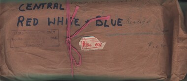 Bendigo Historical Society Inc.
Document - MCCOLL, RANKIN AND STANISTREET COLLECTION: CENTRAL RED WHITE AND BLUE - BUNDLE OF PAPERS, 1912
Documents: Whitelaw Central Red White and Blue Mine Bendigo. 28 pages summary of gold mining correspondence - mortgage mining leases 943689340, contract of sale to Central Blue Gum GM 1933, leases with mining rights, treatment of pyrites agreement 1917 - J. Edwards & Co, Helen Streader - release of liability after being paid (pounds)125 by mine due to accidental death of husband 1912. Another for Ellen Lane 1916, list of titles held by Co , lease agreements Filcock and Manning, Andrew Harkness 'winding plant at mine' 1923, notice to perform agreement to Manning's 1916, Edwards Metallurgical Works 1917, map for 9777 Bendigo, contract for explosives with Dalgety & Co 1917, new scrip for lost shares 1917, Miner's Right 1911, sale of land Ra. A. Rankin 1910.MCCOLL RANKIN AND STANISTREETorganization, mining, central red white and blue, mccoll rankin and stanistreet. -
Bendigo Historical Society Inc.
Map - BENDIGO GOLDFIELD VERTICAL PROJECTIONS
Map of Bendigo Gold Field in two sections showing 'vertical projections along several anticlinal axial planes showing pitch, stratigraphical zones, faultlines, shafts and etc.'. Bulletin No 47 written top left hand side. Lines of reef described: Christmas line Lancashire line Nell Gwynne line New Chum line Hustlers line Garden Gully line Sheepshead line Mines along the reef lines are listed. This map forms part of the Geological Survey of Victoria, Structure of Bendigo Goldfield report, No. 47, 1923. H.Herman, late Director of Geological Survey. On bottom of second section : Prepared in the Geological Survey Office, Bendigo, under the direction of H. Herman, late Director of Geological Survey, from surveys by H.S. Whitelaw, Field Geologist, assisted by E.S. Usher, A.J.J. Moore and R.A. Keble.Geological Survey of Victoriabendigo, gold mining, reef lines