Showing 271 items matching "woodlands"
-
 Tatura Irrigation & Wartime Camps Museum
Photograph - original, 1870's
Rebecca Shanks from Poyntz Pass County Armagh, Northern Ireland who married Andrew Crawford in 1873.Original sepia portrait of lady wearing a high necked top with white collar. Cameo at neckline and locket and chain around neck.Photograph is on cardboard backing board.On back of portrait - Mrs Rebecca Crawford, Woodlands. On front: Eden Photo Studios Paris Panel Melbourne and Sydneyrebecca shanks, andrew crawford, rebecca crawford -
Whitehorse Historical Society Inc.
Article, The Australian Garden Lover, 1937
Three pages from the Australian Garden Lover. Advertisements for 'Woodlands' Iris Garden, Blackburn and L. Challenor's Horticultural Service, Vermont, also H.D. Purcell Gladioli bulbs, Blackburn.Three pages from the Australian Garden Lover. Advertisements for 'Woodlands' Iris Garden, Blackburn and L. Challenor's Horticultural Service, Vermont, also H.D. Purcell Gladioli bulbs, Blackburn.Three pages from the Australian Garden Lover. Advertisements for 'Woodlands' Iris Garden, Blackburn and L. Challenor's Horticultural Service, Vermont, also H.D. Purcell Gladioli bulbs, Blackburn.horticulture, challenor's horticultural service, vermont, woodlands iris garden, blackburn, purcell, h.d. -
 Sunbury Family History and Heritage Society Inc.
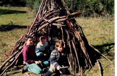
Photograph, Bulla Primary School, Gundiwindi School camp, 14th - 18th August 1989
The photograph was taken in 1989 when the children in grades 4 an 5 attended a school camp at Gundiwindi, which is in the Yarra Valley on the border of Wandin and Nth. Silvan. At the camp the children were acquainted with the skills used by the local indigenous people. The children the photograph attempted to construct a bark shelter along the lines of those build by the local indigenous people. While the children from Bulla Primary School attended the camp at Gundiwindi they were introduced to skills used by local indigenous people.A coloured non- digital photograph of three children sitting at the entrance of a primitive bark shelter. The immediate surrounding area has been cleared but native woodland is growing beyond the fence line. school camps, gundiwindi, bulla primary school, indigenous culture -
 Eltham District Historical Society Inc
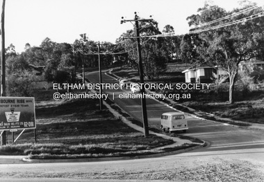
Photograph, R.J. Manuell, Sherbourne Rise, Briar Hill, c.1964
Sherbourne Rise Estate, looking up Woodland Grove from Calrossie Avenue, Briar Hill. The house is believed to be No. 8. This is prior to Regal Court being established off Woodland Grove. View of Squires land which was subdivided for housing - two parts Woodland Crest higher part off Woodland Grove and Calrossi Avenue, Briar Hill showing new roads with curb and channelling and footpaths. No date.Black and white photograph printed with white bordersVerso: COO2briar hill, real estate, woodland grove, squires, roads, sherbourne rise estate -
 Eltham District Historical Society Inc
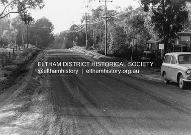
Photograph, R.J. Manuell, Briar Hill, c.1964
View of Squires land which was subdivided for housing - two parts Woodland Crest higher part off Woodland Grove and Calrossi Avenue, Briar Hill showing new roads with curb and channelling and footpaths. No date.Black and white photograph printed with white bordersVerso: COO2briar hill, real estate, woodland grove, squires, roads -
 Eltham District Historical Society Inc
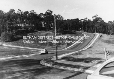
Photograph, R.J. Manuell, Briar Hill, c.1964
View of Squires land which was subdivided for housing - two parts Woodland Crest higher part off Woodland Grove and Calrossi Avenue, Briar Hill showing new roads with curb and channelling and footpaths. No date.Black and white photograph printed with white bordersVerso: COO2briar hill, real estate, woodland grove, squires, roads -
Moorabbin Air Museum
Manual (Item) - Litton Aero Products battery units, Component Maintenance Manual with Illustrated Part List Battery Unit
Litton Aero Products, Woodland Hills, Cailfornia -
Moorabbin Air Museum
Booklet (Item) - Digiprox Ground Proximity System, Litton Aero Products Division Digiprox Ground Proximity Warning System
Litton Aero Products, Woodland Hills, California -
Moorabbin Air Museum
Manual (Item) - Litton Aero Products battery units, Overhaul Manual Battery Unit 510018
Litton Aero Products, Woodland Hills, California -
 Stawell Historical Society Inc
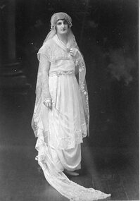
Photograph, Mrs Alice Laidlaw nee McCulloch as a Bride --- Studio Portrait
Portrait Alice Laidlaw (nee McCulloch) as a Bride from Woodlandsstawell -
 Queen Victoria Women's Centre
Newspaper clipping, John Donegan, The reason Y - a new focus for the new women, 6 May 2006
Newspaper clipping from The Age. Unknown page. About the YWCA Victoria new direction. Colour photograph of fourwomen and a baby. 'The new face of the YWCA (from left) Kate Dunn, Erin Dolan, Brodie Woodland with baby Isaac, and Kitty Billings.charitable organisations, committees of management, women professionals -
 Bendigo Historical Society Inc.
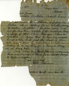
Document - ETHEL PATTISON COLLECTION: ASSISTED PASSAGE DOCUMENT, 1910
Woodlands Dairy Co manager testimonial, handwritten letter on pale blue paper. On top Rh corner ' The Rise, Tennyson Avenue, Scarborough' letter signed by A. Winson, supporting Mr. F. Pattison ( Patterson ) application for a supported passage to Western Australia.fred pattison, assisted passage, western australia, migration -
 Kew Historical Society Inc
Plan - Subdivision Plan, Jas R Mathers Son & McMillan, Eastlawn Estate : East Kew Auction Sale, 1914
The Kew Historical Society's map collection includes a substantial number of real estate subdivision plans, mainly of Kew but also of surrounding suburbs in Melbourne. Most of the subdivision plans date from the 1920s and 1930s when the districts old homes and local farmland were being split up to accommodate residential growth in the postwar period. These early plans were assembled by a local firm, Jas R Mather & McMillan, which had an office in Cotham Road. Many of the plans, and sometimes photos, were annotated by the agents.Subdivision plans are historically important documents used as evidence for the growth of suburbs in Australia. They frequently provide information about when the land was sold as well as evidence relating to surveyors and real estate and financial agents. The numerous subdivision plans in the Kew Historical Society's collection represent working documents, ranging from the initial sketches made in planning a subdivision to printed plans on which auctioneers or agents listed the prices for which individual lots were sold. In a number of cases, the reverse of a subdivision plan in the collection includes a photograph of a house that was also for sale by the agent. These photographs provide significant heritage information relating house design and decoration, fencing and household gardens.The photograph may also be aesthetically significant depending on the importance of the photographic atelier.The ‘Eastlawn Estate’ was surveyed and ready for auction in March 1914, three months before the outbreak of World War I. Sixty-six allotments, created on the ‘order of Mr & Miss Preston’ surrounded the mansion of Woodlands in Harp Road. Woodlands formed part of the Estate, being advertised as lot 1. The allotments faced High, Station and Wright Streets, Harp and Normanby Roads, and Woodlands Avenue. Pru Sanderson in the Kew Conservation Study (Vol.2, 1988) wrote that the Eastlawn Estate ‘covered the western half of the failed Harp of Erin Estate’. Contemporary advertisements promoted the Eastlawn Estate as: ‘There will be no more convenient district nor pleasant Suburb than East Kew for the busy business man. When the Electric Tram is laid, he will be able to journey quickly and pleasantly direct from Collins Street to his home in the Eastlawn Estate in about 20 minutes’. The actual plans of subdivision were included in advertisements in The Argus and in the local newspapers."C" top left. Various annotations.subdivision plans - kew, station street, normanby road, high street, woodlands avenue, harp road, woodlands - kew -
 Kew Historical Society Inc
Plan - Subdivision Plan, Eastlawn Estate, 1914
Subdivision plans are historically important documents used as evidence of the growth of suburbs in Australia. They frequently provide information about when the land was sold on which a built structure was subsequently constructed as well as evidence relating to surveyors and real estate and financial agents. The numerous subdivision plans in the Kew Historical Society's collection represent working documents, ranging from the initial sketches made in planning a subdivision to printed plans on which auctioneers or agents listed the prices for which individual lots were sold. In a number of cases, the reverse of a subdivision plan in the collection includes a photograph of a house that was also for sale by the agent. These photographs provide significant heritage information relating house design and decoration, fencing and household gardens.The ‘Eastlawn Estate’ was surveyed and ready for auction in March 1914, three months before the outbreak of World War I. Sixty-six allotments, created on the ‘order of Mr & Miss Preston’ surrounded the mansion of Woodlands in Harp Road. Woodlands formed part of the Estate, being advertised as lot 1. The allotments faced High, Station and Wright Streets, Harp and Normanby Roads, and Woodlands Avenue. Pru Sanderson in the Kew Conservation Study (Vol.2, 1988) wrote that the Eastlawn Estate ‘covered the western half of the failed Harp of Erin Estate’. Contemporary advertisements promoted the Eastlawn Estate as: ‘There will be no more convenient district nor pleasant Suburb than East Kew for the busy business man. When the Electric Tram is laid, he will be able to journey quickly and pleasantly direct from Collins Street to his home in the Eastlawn Estate in about 20 minutes’. The actual plans of subdivision were included in advertisements in The Argus and in the local newspapers.subdivision plans - east kew, eastlawn estate -
 Bendigo Historical Society Inc.
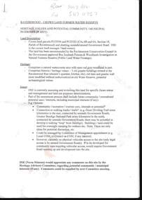
Document - RAVENSWOOD - CROWN LAND - FORMER WATER RESERVE, 20 March 2012
Document, Ravenswood Crown Land, Former Water Reserve, Parish of Ravenswood, Comprises 3 old granite buildings related to the Ravenswood Run. Old dam,and granite wall, potential archaeological values. Ironbark Forests & Woodlands investigation as natural features Reserve.DSR (Norn Stimson)document, ravenswood crown land -
 Stawell Historical Society Inc
Photograph, The Earl of Hopetoun's children 1895 -- Studio Portrait
Portrait - The Earl of Hopetoun's Family 1895. The youngest child was probably born at Woodlands Crowlandsstawell -
Tatura Irrigation & Wartime Camps Museum
Book, My Life, 2006
Written to record the history of James Crawford family, past and present. Life at "Woodlands" contains many family photos and Toolamba historyWhite/off white cover. Black writing. Photo of author in colour on front cover.my life, crawford james, tatura, books, history, local -
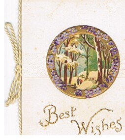 Bendigo Historical Society Inc.
Document - MALONE COLLECTION: GREETING CARDS, 1916
Small white card with narrow raised border and raised dotted area in the centre. Gold circular frame with mauve & purple flowers on it. Inside the frame is a woodland scene with two people walking beneath the trees. 'Best Wishes' printed in gold underneath. Card & insert held together with a cream cord.person, greeting cards, malone collection, malone collection, greeting cards -
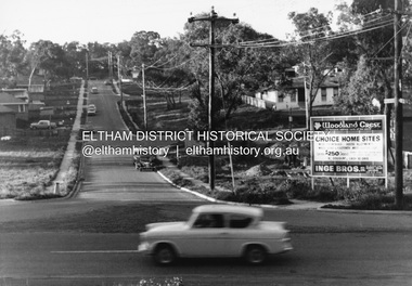 Eltham District Historical Society Inc
Photograph, R.J. Manuell, Woodland Crest, Briar Hill, c.1964
View of Squires land which was subdivided for housing - two parts Woodland Crest higher part off Woodland Grove and Calrossi Avenue, Briar Hill showing new roads with curb and channelling and footpaths. No date. Looking up Hyacinth Avenue, Briar Hill from Sherbourne Road. Hibiscus Avenue first on right then Acacia Court. The white house on Hibiscus Avenue still exists (No. 3)Black and white photograph printed with white bordersVerso: COO2briar hill, real estate, woodland grove, squires, roads, acacia court, hibiscus avenuse, hyacinth avenue, woodland crest estate, inge bros pty ltd -
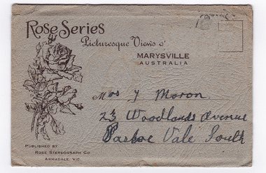 Marysville & District Historical Society
Photograph (item) - Black and white photographs, Rose Stereograph Company, Rose Series Picturesque Views of Marysville Australia, 1913-1967
A series of photographs produced by the Rose Stereograph Company in Victoria, Australia as a souvenir of Marysville.Souvenir envelope containing 12 black and white photographs of natural attractions in Marysville and surrounding area. Published by Rose Stereograph Co, Armadale, Victoria.Rose Series/ Picturesque Views of/ MARYSVILLE/ AUSTRALIA PUBLISHED BY/ ROSE STEREOGRAPH CO/ ARMADALE, VIC. Mrs. J Moron/ 23 Woodlands Avenue/ Pascoe Vale South The date stamp is illegible.the taggerty river marysville vic (image 1), panorama from mt gordon marysville vic (image 2), cora lynn falls marysville vic (image 3), cumberland-cora lynn trip marysville vic at the meeting of the waters (image 4), michael dene marysville vic (image 5), nichols lookout marysville vic (image 6), the stevenson river marysville vic (image 7), cathederal mount from mt gordon marysville vic (image 8), stevenson falls marysville vic (image 9), mountain ash tallest known hardwood tree in world (301ft 6in) cumberland marysville vic (image 10, the main street marysville vic (image 11), talbot drive vic no 12 taggerty river (image 12), rose stereograph company, souvenir, marysville, victoria -
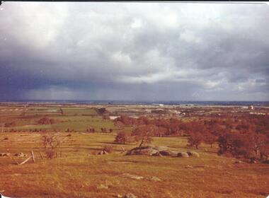
 Hume City Civic Collection
Photograph, September 1994
Woodlands Park complex which includes 'Cumberland' and 'Dundonald' ruins and the Gellibrand Hill Quarries was acquired by the Victorian State Government in 1978 and is managed by Parks Victoria.A view taken from Gellibrand Hill looking east towards the developing suburb of Greenvale. There are small rocky outcrops in the foreground and a clump of conifers and cypress trees in the middle. The sky is very overcast and a range of mountains can be seen across the skyline. Coloured photograph with rounded corners and matt finish.woodlands park, gellibrand hill, greene, william pomeroy, anne, george evans collection -
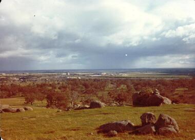
 Hume City Civic Collection
Photograph, September 1994
Woodlands Park complex which includes 'Cumberland' and 'Dundonald' ruins and the Gellibrand Hill Quarries was acquired by the Victorian State Government in 1978 and is managed by Parks Victoria.A view looking west towards the outer limits of the Tullamarine Airport taken from Gellibrand Hill. There is a small rocky outcrop in the middle of the photograph and trees are on the RHS of the image. Coloured photograph with rounded corners and matt finish.woodlands park, gellibrand hill, greene, william pomeroy, anne, george evans collection -
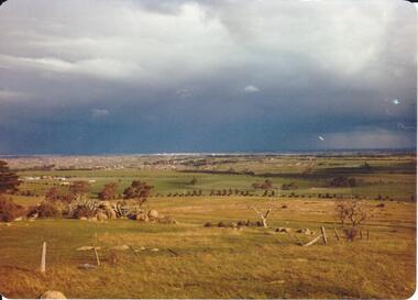 Hume City Civic Collection
Photograph, September 1994
Woodlands Park complex which includes 'Cumberland' and 'Dundonald' ruins and the Gellibrand Hill Quarries was acquired by the Victorian State Government in 1978 and is managed by Parks Victoria.A view taken from Gellibrand Hill looking east towards the expanding suburb of Broadmeadows. Apart from a few rocky outcrops and small trees the open grassland slopes away to a small line of conifers. Coloured photograph with rounded corners and matt finish.woodlands park, gellibrand hill, greene, william pomeroy, anne, george evans collection -
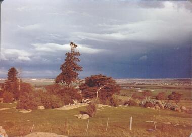
 Hume City Civic Collection
Photograph, Sep-94
Woodlands Park complex which includes 'Cumberland' and 'Dundonald' ruins and the Gellibrand Hill Quarries was acquired by the Victorian State Government in 1978 and is managed by Parks Victoria.A view taken from Gellibrand Hill looking towards the recently constructed Tullamarine (Melbourne) Airport. The airport buildings are just beyond an outcrop of trees. Four rocky outcrops are spread around the foreground. Coloured photograph with rounded corners and matt finish.woodlands park, gellibrand hill, greene, william pomeroy, anne, george evans collection -
 Hume City Civic Collection
Photograph, Sep-94
Woodlands Park complex which includes 'Cumberland' and 'Dundonald' ruins and the Gellibrand Hill Quarries was acquired by the Victorian State Government in 1978 and is managed by Parks Victoria.A view taken from Gellibrand Hill looking northwest. The open grassed area in the foreground is dotted with a number of rocky outcrops with conifers and cypress trees in the background. There are a few buildings in the distance.Coloured photograph with rounded corners and matt finish.woodlands park, gellibrand hill, greene, william pomeroy, anne, george evans collection -
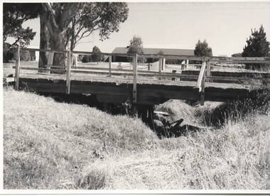 Sunbury Family History and Heritage Society Inc.
Photograph, Timber road bridge, May 1986
The small wooden bridge is spanning an arm of the Moonee Ponds Creek in its upper reaches in Greenvale near Woodlands Park, possibly along Providence Road.A non-digital black and white photograph with a white border of a timber bridge spanning a small creek, which is under a roadway. A country home is visible on the opposite side of the road.bridges, greenvale -
University of Melbourne, Burnley Campus Archives
Plan - Photocopy, Sunshine Planning Scheme, 1993
Photocopies. 18.02.1993. (1) 5 copies Map User Guide - Sunshine Planning Scheme. List of Zones, Reservations and additional Planning Controls. (2) Sunshine Planning Scheme - Local Section. Zones and Reserved Land Map No 2. (3) Map No 3. (4) Map No 4. Used in planning Native Garden Woodlandsunshine, reservations, native garden, planning scheme, victoria department of planning and development -
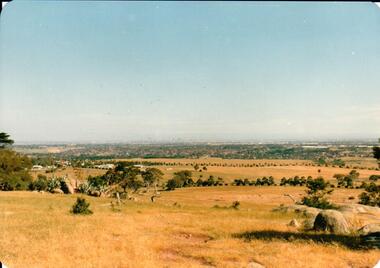 Hume City Civic Collection
Photograph, early 1980s
The Tullamarine Airport opened in 1970 and replaced Essendon Airport as Melbourne's main airport terminal. Gellibrand Hill was incorporated with Woodlands Park and became a public reserve during the 1980s.A coloured landscape photograph with rounded corners taken from Gellibrand Hill and overlooking the Tullamarine Airport which is on the RHS of the photograph. The Melbourne City skyline can be seen in the distance.gellibrand hill, tullamarine airport, melbourne skyline, george evans collection -
University of Melbourne, Burnley Campus Archives
Map, Melbourne Metropolitan Planning Scheme, c. 1978
Maps showing Zones and Reservations in the Merri Creek area of Melbourne, prepared by the Drafting Department, Planning Branch, MMBW. (1) Map No 36, coloured. (2) Map No 37, coloured. (3) Map No 38, not coloured. (4) Map No 46. Scale 1:9600. May have been used in planning the Native Garden Woodland Area. merri creek, melbourne and metropolitan board of works, melbourne metropolitan area -
Clunes Museum
Work on paper - LEAFLET, 2001
During these celebrations the launch was held of the book "16 Tons of Gold; A History of Port Phillip Mine by author John Woodland. Guests were informed of the dress code for the Colonial Ball .1 A4 buff coloured, printed invitation to 150th Discovery of Gold Celebrations on July 1, 2001 .2 School of Mines Roster for entire week of 150th Discovery of Gold Celebrations .3 Document contains information of the Clunes Colonial Ball held to commemorate 150th Discovery of Gold .4 Invitation to the Miners Walk from Ascot to Clunes Diggings Sunday July 1 2001150th celebrations, school of mines roster 2001, clunes colonial ball guest information, discovery of gold celebration