Showing 1515 items
matching aerial photographs
-
 Glenelg Shire Council Cultural Collection
Photograph - Photograph - aerial view of Portland harbour, 1958
... Photograph - aerial view of Portland harbour...Aerial black and white photograph of Portland Harbour... Aerial black and white photograph of Portland Harbour ...Port of Portland Authority ArchivesBack: 14 Jan 1958 - purple stamp. Harb006 - pencilport of portland archives, aerial photography, portland harbour -
Glenelg Shire Council Cultural Collection
Photograph - Photograph - Portland Harbour, n.d
... Aerial black and white photograph of Portland Harbour... Back: harb023- pencil Aerial black and white photograph ...Port of Portland AuthorityBack: harb023- pencilport of portland archives, portland harbour, henty beach -
Stawell Historical Society Inc
Photograph, Aerial Photos of Stawell from a Hot Air Balloon 1985 -- 11 Photos
... Series of 11 colour photographs of aerial photos of balloon... colour photographs of aerial photos of balloon rides over a town ...Series of 11 Aerial Photos of Stawell. Hot Air Balloon 1985. Photo were taken during a second balloon ride in July 1985. Take off venue was the oval at Stawell West Primary School. The balloon course was parallel to the Western Highway out over Deep Lead. 1. Ride left from Stawell West Primary Oval. 2. School Children were brought out to see the balloon launch. 3. Western Highway Green School oval. 4. Central Park Lower Main St. 5. Taylor's Gully Park Sloane St. 6. Shadow of Hot Air balloon on low cloud over Western Highway. 7. North Western Woolen Mills. 8. Pleasant Creek special school. 9. Looking back at Stawell. 10. Grampians & Lake Lonsdale. 11. Over Deep Lead. Series of 11 colour photographs of aerial photos of balloon rides over a town. stawell -
 Federation University Historical Collection
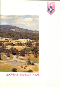
Book, Ballarat University College Annual Report, 1989
... Soft covered book with an aerial photograph of the Mount... covered book with an aerial photograph of the Mount Helen campus ...The President of Ballarat University College in 1989 was E.T. Oppy.Soft covered book with an aerial photograph of the Mount Helen campus and Mt Buninyong on the cover. The annual report includes a background of the establishment and governance of Ballarat University College, Remote Sensing Laboratory, Naming of E.J. Barker Library, Computer Centre, Financial Statement The report outlines the completion of the following buildings: * Mt Helen Adminsitration Building * Mt Helen Creche *Physical education Office Extension * Geology Annex the following buildings were commenced: * Staff/Student extension * Librarianship/Business Offices 8 Art extensionballarat university college, oppy, barker, e.j. barker library -
City of Kingston
Photograph - Colour, c. 1993
... Laminated colour aerial photograph of the Carrum... Swamp Canals and waterways Laminated colour aerial photograph ...Patterson Lakes is a suburb in the City of Kingston that is built one kilometre upstream of the mouth of the Patterson River. The area is bordered by the Patterson River and Eel Race Drain which enters the Kananook Creek. The suburb consists predominantly of newer housing developments and the tidal canal system of the development joins Port Phillip Bay.Patterson Lakes and the Kananook Creek were previously part of the extensive Carrum Carrum Swamp. The area was once a source of fish and eels for the Mayone-Bulluk clan of the Bunurong people. Over time the area was drained and in 1973 investigations commenced into the development of a unique residential area that would be built adjacent to canals and waterways. It was originally proposed to be known as "Gladesville". The development would give the suburb's homeowners access to Port Phillip Bay "from their back door". Circa 1974, the area was rezoned from rural to residential and named Patterson Lakes. Development has been continuous since the 1970s with construction of residential housing, schools, shopping centres, marinas, a hotel and library.Laminated colour aerial photograph of the Carrum and Patterson Lakes region within City of Kingston. This 1993 image includes Patterson River Secondary College, Roy Dore Reserve, Kananook Creek and Nepean Highway. The railway line can be seen as it veers inland from Eel Race Road, Seaford. The section of Palm Beach Drive, Curlew Point Drive, Snapper Point Drive, Clipper Island and Myola Street in Patterson Lakes appears to be a recent development with many spare blocks and new houses under construction.patterson lakes, seaford, kananook creek, carrum carrum swamp, canals and waterways -
City of Kingston
Photograph - Colour, 29 January 1993
... Laminated colour aerial photograph of the Bonbeach, Carrum... aerial photograph of the Bonbeach, Carrum and Patterson Lakes ...Bonbeach, Carrum and Patterson Lakes are suburbs in the City of Kingston. Bonbeach and Carrum were holiday destinations in early 20th century and over time the housing has converted to permanent residential structures. In Patterson Lakes, the area consists predominantly of newer housing developments and the tidal canal system which is accessible to many dwellings joins Port Phillip Bay.Bonbeach, Carrum and Patterson Lakes were previously part of the extensive Carrum Carrum Swamp. The area was once a source of fish and eels for the Mayone-Bulluk clan of the Bunurong people. Over time the area was drained and this allowed farming at Carrum and Bonbeach, although the area was prone to flooding. In the early 1920s and 30s the land was converted to residential dwellings. In 1973 investigations commenced nearby to Bonbeach and Carrum into the development of a unique residential area comprising canals and waterways. It was originally proposed to be known as "Gladesville". Circa 1974, the area was rezoned from rural to residential and named Patterson Lakes. Development has been continuous since the 1970s with staged construction of the waterways, residential housing, and supporting infrastructure and facilities.Laminated colour aerial photograph of the Bonbeach, Carrum and Patterson Lakes region within City of Kingston. This 1993 image includes Bonbeach High School prior to demolition, Bonbeach Primary School and Patterson River Golf Club. Sections of Patterson Lakes are not yet developed, including Rhode and Staten Islands. Long Island Point appears to be a recent development with many spare blocks and new houses under construction. The Patterson River marina is prominent and the river mouth as it meets Port Phillip Bay. The Carrum railway station is visible.Black type on white adhesive sticker: No. 6661 Black type on white adhesive sticker: 26E/6661, 29/1/93, 4.25 pm Black type on white adhesive sticker 29-1-93 Yellow circular adhesive stickerbonbeach, carrum, patterson lakes, patterson river, carrum carrum swamp, canals and waterways -
City of Kingston
Photograph - Black and white, 17 January 1951
... Aerial photograph of Cheltenham, Moorabbin and Highett... ↆ M539 Black pencil: N [arrow] Aerial photograph ...Moorabbin, Cheltenham and Highett are suburbs in the City of Kingston with a diverse mix of development and zoning. This 1954 image shows the market gardens, farms and paddocks of the Moorabbin and Cheltenham area. which have gradually been sub-divided into The Highett Gas Works is visible and Cheltenham Park and Victoria Golf Club.The suburbs of Cheltenham and Moorabbin were originally developed with extensive market gardens. Over time the district has been transformed with the farms and paddocks replaced by housing, factories and shopping centres. The Highett Gas Works on the Nepean Highway was a significant feature of the landscape and has now been demolished. and the site has undergone remediation.Aerial photograph of Cheltenham, Moorabbin and Highett within the City of Kingston. The area depicted in this 1951 aerial view includes Wickham Road, Highett (bottom right), Keys Road, Moorabbin (bottom left), Centre Dandenong Road Cheltenham (top left), Park Road, Cheltenham (top right), Nepean Highway (left section), Graham Road and Middleton Street, Highett (bottom right). Cheltenham Park and Victoria Golf Club are visible. Nepean Highway and the Frankston railway line run centrally through the image.White type: 1416-37 538 RUN239 LENS 5312" MELBOURNE METROPOLITAN 12150 17-1-51 ↆ M539 Black pencil: N [arrow]cheltenham, highett, highett gas works, market gardens -
 Melbourne Tram Museum
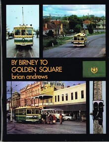
Book, Brian Andrews, "By Birney to Golden Square", 1973
... on the rolling stock with an aerial photograph of Bendigo with the tram..., depot, notes on the rolling stock with an aerial photograph ...Book, 78 pages including card cover, printed on gloss paper, titled "By Birney to Golden Square", written by Brian Andrews, published by Southern Cross Traction, Kensington Park SA. Sub-titled "The last years of Bendigo's tramways", 1973. Features both black and white and colour photographs, including tickets, photos along each route, Charing Cross, depot, notes on the rolling stock with an aerial photograph of Bendigo with the tram routes marked in and a fold out detailed map of Bendigo and its track layout.trams, tramways, secv tramways, bendigo, maps -
 Alfred Hospital Nurses League - Nursing Archive
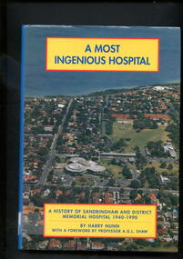
Book - Illustrated book, Harry W.(Wilfred) Nunn, A most ingenious hospital: history of Sandringham and District memorial Hospital 1940-1990, 1990
... . Front cover has aerial photograph to the hospital c.1990...)'s logo printed in white on spine. Front cover has aerial ...This book covers the history of the Sandringham and District Memorial hospital from when it was first mooted in the early 1940's, through its opening in 1964, until 1990Illustrated book with dust jacket. Hardcover is bound in dark blue, with abbreviated title, authors name, and publisher (Sandringham and district memorial hospital)'s logo printed in silver on spine. Dust jacket back cover and spine is mid blue in colour , with abbreviated title, authors name, and publisher (Sandringham and district memorial hospital)'s logo printed in white on spine. Front cover has aerial photograph to the hospital c.1990 as background, with full title and authors name printed in blue on yellow rectangles with red borders non-fictionThis book covers the history of the Sandringham and District Memorial hospital from when it was first mooted in the early 1940's, through its opening in 1964, until 1990 -
 Warrnambool and District Historical Society Inc.
Map - An Angler's map of the Hopkins River Estuary, Angler's map Hopkins River, 1980s
... of the information has been gathered from aerial photographs. The map has... gathered from aerial photographs. The map has been produced ...This is a map of the Hopkins River Estuary prepared by Dr John Sherwood for the benefit of anglers. The information on the sheet includes the location of sand banks, the water depths, boat ramp facilities and public access facilities. Some of the information has been gathered from aerial photographs. The map has been produced by the Warrnambool Institute of Advanced Education which was developed in the late 1960s from the tertiary section of the Warrnambool Technical College and with all its departments established by 1984 at the Sherwood Campus five kilometres from Warrnambool on the Princes Highway. Today the site is occupied by Deakin University, Warrnambool campus. The Warrnambool Anglers’ Club has its headquarters on the banks of the Hopkins River near the mouth of the river and the Lyndoch Aged Care facility.This map is of interest as a specialist one, providing fishermen with detailed information on all aspects of the Hopkins river estuary. Fishing has been both a profession and a popular recreational pursuit for Warrnambool residents since the early days of the city’s settlement. The Hopkins River Estuary has been a focal point for fishermen throughout Warrnambool’s history. This is a sheet of paper folded three times to produce a folded map. The front cover has a black and white photograph of two fishermen with a large fish. The map of the Hopkins River Estuary is in yellow, blue and black and covers the side of one sheet and three quarters of the other side. There is an advertisement for the Hopkins River Boathouse with a black and white sketch of the boathouse and notes on the map written by Dr John Sherwood. There are several diagrams showing the water depths. The map has some silverfish damage and some tearing at the folds. warrnambool anglers’ club, history of warrnambool, hopkins river, hopkins river estuary, john sherwood -
 Kiewa Valley Historical Society
Photograph - Mount Beauty from Bogong Hill, 1950
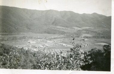
... Black and white photograph - aerial view of Mt Beauty taken... Volox 2428 Black and white photograph - aerial view of Mt Beauty ...The new State Electricity Commission construction camp at the head of the Kiewa Valley was for workmen on the second power station in the project expected to be the most modern and best equipped in Australia… In contrast to the early Kiewa days of horses and canvas tents, the new camp, with its modern amenities, compared favourably with any country town. Administration of the Kiewa Scheme was moved from Tawonga to Mount Beauty in 1946. The first house in Mount Beauty, in Hollonds Street, was occupied by the co-op store manager from November 1946. The new Mess Hall at Mt Beauty was opened with much ceremony in early November 1946. The houses up to Nelse street were erected from 1946 onward and then the township was extended beyond Nelse Street in 1950. The workmen's camp was enlarged in 1950 to the extent of providing accommodation for a total of 1,200.Shows early construction of the town of Mt. Beauty surrounded by farmland taken in 1950 during the early stages of construction of the Kiewa Hydro electric SystemBlack and white photograph - aerial view of Mt Beauty taken from Bogong Hill. Photograph framed by 6mm white boarder.Handwritten on back of photograph in black ink - Mt Beauty from Bogong Hill 1950 Printed on rear Volox 2428mt beauty, bogong hill, secv -
Glen Eira Historical Society
Document - Classic Retirement Village, Brighton
... Auditor General’s Department website with aerial photograph 2... with aerial photograph 2/A copy of page one of the Gleneira Planning ...Four documents about the history of this site pre Classic Retirement Village: 1/A copy of a description of the sale process of the Gascor site, cnr Nepean Highway and Thomas Street, to Becton Corporation in 1997 And 1998. Printed on 31/07/2010 from the Victorian Auditor General’s Department website with aerial photograph 2/A copy of page one of the Gleneira Planning Scheme dated 19/01/2006 which mentions the Gascor site. 3/Research note by Andrew Frederick dated August 2010 listing occupiers of the site in the 1960 and the 1970 Sands and Mc Dougall Directories. 4/Research note by Claire Barton dated May 2010 containing Ian Swan’s recollections of working at Daylesford Worsted Woollen, occupier of the site, in the 1960s.thomas street, brewer road, bentleigh, gascor, becton corporation pty ltd, virginia park, gas and fuel, hughesdale dairy, east boundary road, moorabin, east bentleigh, hooblerstone, clairmont avenue, glen eira, daylesford centenary woollen and worsted mills pty ltd., nepean highway, f and j industries australia plastic and rubber division., swan ian, korman stanley, mills, wool industry, weaving mills, textile factories, textile manufacturing, manufacturing industry -
 International House, The University of Melbourne
Photograph (Item), Aerial view of the site of International House (includes Scheps Building)
... Black and white photograph of Aerial view of the site... Parade Parkville melbourne Black and white photograph of Aerial ... -
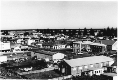
Glenelg Shire Council Cultural Collection
Photograph, Aerial view of North West Portland, 1968
... Black and white photograph. Aerial view of North West... and white photograph. Aerial view of North West Portland; wool ...Port of Portland Authority archives.Front: (no inscriptions) Back: WOOL STORES & T.B + S AT NORTH PORTLAND/ PORTLAND HARBOUR TRUST COMMISSIONERS/ JAN 1968port of portland, wool stores, thomas borthwick -
 Port Melbourne Historical & Preservation Society
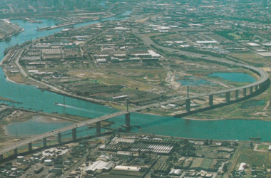
Postcard - Aerial view of West Gate Bridge, c. 1985
... Colour postcard showing a photographed aerial view... - industrial fishermans bend Colour postcard showing a photographed ...Colour postcard showing a photographed aerial view of the West Gate Bridge. Also visible is the aircraft factory and the industrial area of Fishermens Bendwest gate bridge, engineering - bridges, built environment - industrial, fishermans bend -
![Booklet: Historic Aradale [NMIT Site Plan and Introduction 2003], HiBooklet: Historic Aradale [NMIT Site Plan and Introduction 2003]](/media/collectors/4fac93a2023fd71f703efeec/items/50bbef912162ef06b884a6bc/item-media/50bc39322162ef06b884f20b/item-fit-380x285.jpg) NMIT (Northern Melbourne Institute of TAFE)
NMIT (Northern Melbourne Institute of TAFE)Booklet: Historic Aradale [NMIT Site Plan and Introduction 2003], HiBooklet: Historic Aradale [NMIT Site Plan and Introduction 2003]
... aerial photograph of Aradale campus 2003. Also VHS video Ararat... of Aradale Campus Sunday 17 November 2002. Also large aerial ...Twenty-seven page colour booklet, with introduction and site plans for the Ararat Campus of NMIT, 2003. One large A3 copy and one smaller A4 copy. Also Program for Official opening of Aradale Campus Sunday 17 November 2002. Also large aerial photograph of Aradale campus 2003. Also VHS video Ararat Rural City Council celebrates rebirth of Aradale, Ballarat Win TV State television news 15/3/2002. Bill Braithwaite, Ararat Rural City Council, Peter Ray, NMIT.aradale, nmit ararat, aradale site plan, program for official opening 2002, nmit -
City of Kingston
Photograph - Black and white, 3 March 1954
... Aerial photograph of Mentone, Cheltenham and Moorabbin...] Black pencil: S [arrow] Black ink: 3/3/1954 Aerial photograph ...Cheltenham and Moorabbin are suburbs within the City of Kingston that were originally established as rural market gardening communities The area is bordered by Highett and Mentone. The market gardens, farms and paddocks have gradually been sub-divided into housing and industrial estates. Highett is developed with residential homes but was also the site of major facilities such as the Highett Gas Works. This aerial image covers a diverse section of the City of Kingston, taking in the suburbs of Moorabbin, Cheltenham, Highett and Mentone Residential housing development is prominent along the Frankston Railway line and the area still retains extensive market gardens and paddocks yet to be converted to a large industrial and commercial zone.Aerial photograph of Mentone, Cheltenham and Moorabbin within the City of Kingston. The area depicted in this 1954 aerial view includes Warrigal Road and Centre Dandenong Road intersection (top left); Charman Road, Patty Street, Bourke Street, Collins Street Mentone (top right); Keys Road Moorabbin (bottom left); Bay Road, Cheltenham (bottom right), Friendship Square, Cheltenham Park, Victoria Golf Club and Jack Barker Oval are visible. Nepean Highway and the Frankston railway line run centrally through the image. Highett Gasworks is also evident.White handwriting and type [indecipherable]. White image of clockface White image of compass White type 42956 Black handwriting 3/3/54 Williams [indecipherable] Black pencil: S [arrow] Black ink: 3/3/1954cheltenham, moorabbin, mentone, highett, market gardens -
Glenelg Shire Council Cultural Collection
Photograph, View of Lady Bay reclaimation and Pivot Fertiliser Works, 21/03/1972
... Black and white photograph. Aerial view of Lady Bay... photograph. Aerial view of Lady Bay reclaimation, Pivot Fertiliser ...Port of Portland Authority archives.Front: (no inscriptions) Back: (no inscriptions)port of portland, lady bay, pivot fertiliser works -
Glenelg Shire Council Cultural Collection
Photograph, Aerial view of Cape Grant, n.d
... Black and white photograph. Aerial view of Cape Grant... and white photograph. Aerial view of Cape Grant quarry from the S.E ...Port of Portland Authority archives.port of portland, cape grant quarry -
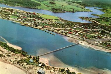
 Lakes Entrance Regional Historical Society (operating as Lakes Entrance History Centre & Museum)
Photograph - Lakes Entrance, 1960c
... Colour photograph aerial view of the township, shows also... photograph aerial view of the township, shows also Cunninghame Arm ...Copied from postcardColour photograph aerial view of the township, shows also Cunninghame Arm, the hummocks and distant view of Bullock Island and the entrance. Lakes Entrance Victoria hotels, township, waterways -
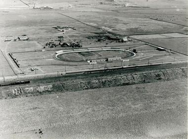 Sunshine and District Historical Society Incorporated
Photographs - WHITE CITY, Pratt, Charles Daniel, (1892 - 1968)
... Two low aerial photographs of the White City Coursing.... We do not hold a copy of these. Two low aerial photographs ...The White City Greyhound racing stadium was built at Tottenham in 1927, with the intention that mechanical lures and not live hares be used as pacemakers. The first meeting was held on 10 December 1927 but within 3 days, after strong lobbying by other sports bodies, the Victorian Government banned betting on greyhound racing if mechanical lures were used instead of live hares. This caused some financial problems to the shareholders. For a time the average weekly attendances were 9000, and races were held on Mondays, Wednesdays, and Saturdays. Whippet Races, Goat Races, Monkeys on greyhounds, and Professional Foot racing were also tried to attract attendances. After 28 years of bureaucratic interference, and using live hares as greyhound pacemakers, the White City stadium held its last meeting on 29 December 1955. On 31 December the Victorian Government finally allowed betting on greyhound races that used mechanical lures. Manufacturing industry (Olex Cables) took over the White City site. Transport to the White City stadium was provided by train, with only a single platform available on the Down side of Tottenham, even though double train lines existed. Special train services were run from Flinders Street to the White City platform, and for a while a parcels coach was provided for the transport of dogs. As industry developed in the area some trains also stopped at the White City platform in the mornings and late afternoons to transport workers. In 1981 when the grade separation at Ashley Street next to the Tottenham station was completed, the new train lines on the Upper Level came into operation, and so the White City platform was closed down and eventually demolished. The above historical information was sourced from the booklet "GOING TO THE DOGS" by Tom Rigg.Greyhound racing has always been popular in Melbourne's western suburbs. The White City stadium in Tottenham was a major centre for the sport until 1955, enabling those who could not afford race horses to take part in an animal racing sport. The demolition of first the stadium and years later the railway platform, has relegated the name White City and its past relevance to the western suburbs, into history.Two low aerial photographs of the White City Coursing stadium (Greyhound racing), plus a CD containing the same two images as well as a few other local images. The Coursing stadium was located about 500 metres from the Tottenham railway station on the down line towards Sunshine station. The photographs are thought to be from circa late 1920's to early 1930's, and one shows the view from the north facing south, while the other from the west facing east. The latter also shows built up areas of West Footscray and beyond.Only on the negatives at the State Library. We do not hold a copy of these.white city, greyhound racing stadium, coursing track, white city station, tottenham, whippet, gambling, live hare, mechanical lure -
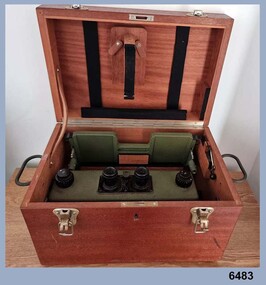 Bendigo Military Museum
Instrument - Old Delft Scanning Stereoscope ODSS III, C. 1956
... the aerial photographs. In the public and private sector it was also... the aerial photographs. In the public and private sector it was also ...This is a superbly crafted cartographic mapping instrument. It is housed in its own high-quality purpose-built oak box. Made in the Netherlands from 1950 onwards. This instrument is from c 1956. it is a very high-quality military grade stereoscope that was generally used by photographic interpreters such as intelligence analysts but was equally useful for mapping activities. The stereoscope was used to examine 3D aerial photographic images. This instrument has a particularly useful capability to scan over the 3D stereo model using X and Y movement knobs, rather than having to physically move the aerial photographs. In the public and private sector it was also useful for photogrammetric interpretation for Forestry and Agricultural purposes. See also Bendigo RSL Collections Victoria item Number 6205.6P that shows the Old Deft Stereoscope in use at the Army Survey Regiment, Bendigo.This is an "Old Delft" scanning stereoscope with its reflecting carriage and legs. The Stereoscope is housed in its own purpose built wooden oak box that has dovetail joints, 2 x securing clips, 2 x handles and a lock (without key). The instrument is assembled by inserting colour coded legs into their matching slots."OLD DELFT SCANNING STEREOSCOPE ODSS III" "Patents Applied for" "OLD DELFT C4790" "MADE IN THE NETHERLANDS"royal australian survey corps, rasvy, fortuna, army survey regiment, army svy regt, asr -
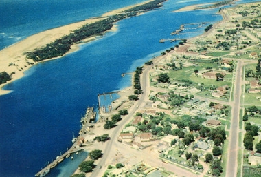
 Lakes Entrance Regional Historical Society (operating as Lakes Entrance History Centre & Museum)
Photograph - Lakes Entrance, 1975c
... Aerial Photograph...Colour photograph aerial view of the township, also showing... Aerial Photograph Colour photograph aerial view of the township ...Copied from postcardColour photograph aerial view of the township, also showing North Arm, Cunninghame Arm, footbridge, and kiosk and Lifesaving Club on hummocks. Lakes Entrance Victoriawaterways, township, islands, jetties, aerial photograph -
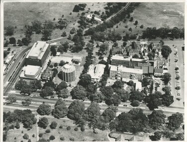
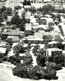 Federation University Historical Collection
Photograph - Black and White, Aerial Photograph of Federation University Mount Helen Campus
... Aerial Photograph of Federation University Mount Helen...Aerial photograph...Aerial black and white photograph of Federation University... university Aerial photograph Aerial black and white photograph ...Federation University Australia was established on 1 January 2014. Formerly known as the University of Ballarat, its enabling legislation was the University of Ballarat Amendment (Federation University Australia) Act 2013. Although formally created as a University in 1994, the University of Ballarat has a lineage back to 1870 with the establishment of the School of Mines Ballarat, making it the third institution of higher learning to be established in Australia and the first to be established in regional Australia. On 1 January 1994, Ballarat University College became the University of Ballarat and in 1998 the University merged with three TAFE Institutes to become a dual sector institution with multiple campuses. On 1 January 2014, the University of Ballarat amalgamated with the Monash University Gippsland Campus to form Federation University Australia. The Gippsland Campus also had a long lineage dating back to 1928 with the establishment of the Yallourn Technical School which became a predecessor institution to the Gippsland College of Advanced Education formed in 1968. In 1990, it was renamed the Monash University College and in 1993 became the Gippsland Campus of Monash University. In 2016, Federation University Australia announced plans to take possession, over a two-year period, of Monash’s Berwick Campus in the south-east corridor of Melbourne. Federation University Australia, or FedUni, is headquartered in Ballarat and offers programs in Higher Education and Vocational Education and Training to regional Victoria and beyond. The University’s commitment to educational and social equity, teaching excellence, research distinction, environmental sustainability and regional capacity building has enabled it to develop in a way that draws on its proud heritage to inform its future. Its regional character sets a framework for the University’s priorities but does not constrain it from serving wider community interests, nationally and internationally. The name Federation University Australia was chosen to convey the scope and capacity of an expanded regional university with a federated network of campuses.Aerial black and white photograph of Federation University Mount Helen Campus taken from Chancellor Drive.mount helen campus, federation university, aerial photograph -
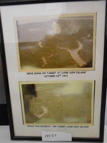 National Vietnam Veterans Museum (NVVM)
Photograph, Air Attack at Long Son Island, 22/10/1971 12:00:00 AM
... Two Black Framed colour Photograph of Aerial attack on Long... Island Aerial attack Two Black Framed colour Photograph of Aerial ...Two Black Framed colour Photograph of Aerial attack on Long Son Island on October 22 1971photograph, long son island, aerial attack -
 Port Fairy Historical Society Museum and Archives
Photograph
... Black and white photograph of aerial view Caledonian... victoria hotel Black and white photograph of aerial view Caledonian ...SE view from St Johns Tower 1973Black and white photograph of aerial view Caledonian & Victoria Hotels centre. Reardon theatre far leftst john's tower, tower, st johns, town, aerial, caledonian, victoria, hotel -
 Ringwood and District Historical Society
Article - Newspaper Clipping, Land Sale Advertisements, Golden Hill Estate, Ringwood - 1965, 1966, and Plan of Survey of Lot 8, Mullum Mullum Road Ringwood, 1970
... - Golden Hill Estate, Ringwood, with summary of features and aerial..., Ringwood, with summary of features and aerial photograph including ...Newspaper clippings from Melbourne Sun newspaper (11th December 1965 and 15th January 1966) advertising sale of land - Golden Hill Estate, Ringwood, with summary of features and aerial photograph including artistic representation of street layout. Subdivision includes Mullum Mullum Road, Sonia Street, Jill Court, Linda Drive, Eve Court, Alma Court, and Jacynthe Court. Attachments include reference to Lot 46 as site of original Peter Vergers' orchard residence and subsequent 1970 surveyor's Plan of Survey of Lot 8 Mullum Mullum Road Ringwood, LP 67513, Cert of Title 8581/429.Agent - Aaron, King & Co., Suite 2, 33 Queens Road, Melbourne. (Phone) 26-2443, A.H. 850-2195. Plan of Survey signed on 25.7.1970 by Roger M. Gamble, Land Surveyor, 28 Summit Crescent, Ringwood 3134. -
Federation University Historical Collection
Booklet, Ballarat School of Mines, Ballarat School Of Mines Agenda for meeting with Chairman of the TAFE Board, 07/1985
... * Uncertainties Re Blackburn The booklet also includes an aerial... The booklet also includes an aerial photograph of the Ballarat School ...Yellow covered A$ booklet bound with plastic. The book as in agenda for a meeting with I. Predl, acting Chairman of the TAFE Board. Items for discussion were: * L.F.J. Hillman Recreation Building * Maintenance of Buildings * Campus titles and future development * Quality Improvements * College Management Study * Uncertainties Re Blackburn The booklet also includes an aerial photograph of the Ballarat School of Mines campus, including dates each building was erected. The image shows the site of the newly demolished Ballarat Gao, and still has a tennis court and Mining laboratory onsite. The book also show allotment plans of the Ballarat School of Mines site. -
City of Kingston
Photograph - Colour, 29 January 1993
... Laminated colour aerial photograph of the suburb... Laminated colour aerial photograph of the suburb of Bonbeach ...Bonbeach is a small beachside suburb located between Chelsea and Carrum. The station was opened in 1926 and was the last to be established in the group from Aspendale to Carrum. Urban growth began after World War II. State primary and high schools were opened in 1958 on land in Breeze Street that was once occupied by The Australian Glass Manufacturers. Immediately east of the school sites is the Patterson River Golf Club. The Bonbeach sports reserve has five ovals and is home to the Bonbeach football and baseball clubs. The suburb borders the Edithvale-Seaford Wetlands which is the remnant site of the Carrum Carrum swamp, once the home of the Bunurong people.Bonbeach was originally a seaside destination for holidaymakers and the housing comprised of holiday homes and gradually more permanent residents. It was not until 1926 that Bonbeach had its own railway station. From 1906 until the late 1940s sand was quarried on the east side of the railway line and used in the manufacture of glass. The Australian Glass Manufacturers sold this land in residential blocks and Bonbeach's permanent population spread from the coastal strip across to the other side of the railway line. Laminated colour aerial photograph of the suburb of Bonbeach and also the southern section of neighbouring Chelsea within the City of Kingston. The extent of this 1993 aerial image includes: Top left - Maury Road at the south end of the Chelsea shopping Centre; Top right - Scotch Parade Chelsea Bottom left - Monica Avenue in Bonbeach; Bottom right - Patterson River Golf Club. Landmarks include St Joseph's Church and Primary School, Chelsea Primary School, Bonbeach Station, Bonbeach Fotball Club sports playing fields and Bonbeach Life Saving Club. The Edithvale Wetlands is featured prominently to the right-hand side of the image. Black typed writing on white adhesive label: No. 6662 Black typed writing on white adhesive label: 26E/6662, 29/1/93, 4.25 pm Black typed writing on white adhesive label: 29-1-93 Black typed writing on white adhesive label: P000109 Circular yellow adhesive sticker bonbeach, chelsea -
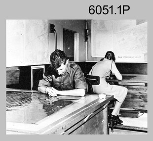 Bendigo Military Museum
Photograph - Retouching Reproduction Material at the Army Survey Regiment, c1960s, c1970s
... projecting a scaled projected aerial photograph as a positional... projecting a scaled projected aerial photograph as a positional ...The first four photographs were most likely taken in the 1960 and the fifth in the 1970s at the Army Survey Regiment, Fortuna, Bendigo. As there are no annotations with the photos, the exact dates, locations and names of personnel are unknown. SGT Bob Scaddan appears in the fifth photo taken in the 1970s Photos .1P and .2P. could have been taken in Lithographic Squadron’s retouching room and Photos .3P, .4P and .5P. were probably taken in Cartographic Squadron’s Correcting Section, located in the Attic. Retouching mainly entailed the application of liquid opaque (Plumtree), commonly known as “duff” to cover blemishes such as scratches and spots on film negatives before photographic exposure. Retouching technicians also used specialised techniques such as “needling” to repair faults on the emulsion of map reproduction material. The technician in photo .4P is needling a hydrographic feature on a drainage negative, with a zoom transfer scope projecting a scaled projected aerial photograph as a positional reference. This is a set of five photographs of technicians retouching reproduction material at the Army Survey Regiment, Bendigo. The photographs were printed on photographic paper and are part of the Army Survey Regiment’s Collection. The photographs were scanned at 300 dpi. .1) - Photo, black & white, c1960s. unidentified personnel in Lithographic Squadron. .2) - Photo, black & white, c1960s. unidentified personnel in Lithographic Squadron. .3) - Photo, black & white, c1960s. unidentified personnel in Cartographic Squadron Attic. .4) - Photo, black & white, c1960s. unidentified personnel in Cartographic Squadron Attic. .5) - Photo, black & white, c1970s. SGT Bob Scaddan in Cartographic Squadron..1P to .3P, .5P - annotated “Retouching”royal australian survey corps, rasvy, army survey regiment, army svy regt, fortuna, asr, litho, carto