Showing 2469 items matching " black bridge"
-
 Eltham District Historical Society Inc
Photograph, Brougham Street, Eltham, c. Sep. 1966
Taken from alongside the Justice Precinct looking east. In the distance on the right hand verge there is a large Eucalyptus tree with a branch growing out over the road. That tree still stands today and is outside No. 102. The two houses on the right are possibly numbers 94 and 96.Black and white photographic printOriginally located in a Filmpro King Size Prints processing envelope $3.01 Shire of Eltham 9/9/66 and noted as Calrossie Ave area and crossed out Eltham-Yarra Glen Road, Bridge Street to Elsa Court existing conditions mid 1967brougham street, eltham, infrastructure, road construction, roads -
 Eltham District Historical Society Inc
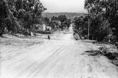
Photograph, Brougham Street, Eltham, c. Sep. 1966
Large tree on left near truck still standing today outside No. 121.Black and white photographic printOriginally located in a Filmpro King Size Prints processing envelope $3.01 Shire of Eltham 9/9/66 and noted as Calrossie Ave area and crossed out Eltham-Yarra Glen Road, Bridge Street to Elsa Court existing conditions mid 1967brougham street, eltham, infrastructure, road construction, roads, bible street -
 Eltham District Historical Society Inc
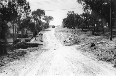
Photograph, Brougham Street, Eltham, c. Sep. 1966
Taken from near No. 113 looking west. There is a boy walking up the road and past him a truck turning right into Bible Street. Further down the road near the EK Holden is a Eucalyptus tree with branch overhanging the road that still stands today (2021) outside No. 102.Black and white photographic printOriginally located in a Filmpro King Size Prints processing envelope $3.01 Shire of Eltham 9/9/66 and noted as Calrossie Ave area and crossed out Eltham-Yarra Glen Road, Bridge Street to Elsa Court existing conditions mid 1967brougham street, eltham, infrastructure, road construction, roads, bible street -
 Eltham District Historical Society Inc
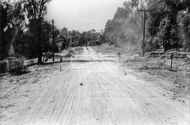
Photograph, Brougham Street, Eltham, c. Sep. 1966
Looking east No. 117. Large tree on left near electric pole still standing today in front of No. 121.Black and white photographic printOriginally located in a Filmpro King Size Prints processing envelope $3.01 Shire of Eltham 9/9/66 and noted as Calrossie Ave area and crossed out Eltham-Yarra Glen Road, Bridge Street to Elsa Court existing conditions mid 1967brougham street, eltham, infrastructure, road construction, roads -
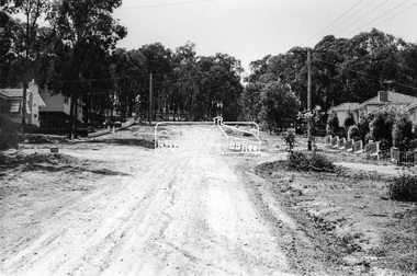 Eltham District Historical Society Inc
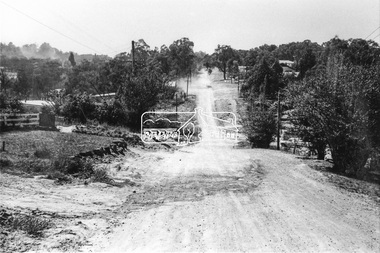
Photograph, Bridge Street, Eltham, c. Sep. 1966
Last house on right is No. 122. The three houses on right remain relatively original in present time, the two visible houses on left have been substantially altered or replaced. Bridge Street ended at this point but has since been further extended eastBlack and white photographic printOriginally located in a Filmpro King Size Prints processing envelope $3.01 Shire of Eltham 9/9/66 and noted as Calrossie Ave area and crossed out Eltham-Yarra Glen Road, Bridge Street to Elsa Court existing conditions mid 1967eltham, infrastructure, road construction, roads, bridge street -
 Eltham District Historical Society Inc
Document - Map, Doug Orford, Main Road, Eltham (c..1930s-1970s), c.2010
Map of Main Road with listings of all properties (shops/homes) from Mount Pleasant Road through to Pryor Street from the 1930s on to about the 1970sandrew store, andrews newsagency, arthur street, babe taylor house, bakery, barbers blue gum store, blue gum, boarding house, bootmakers cottage, bottle shop, bradford butcher shop, bradford house, bradley house, brdbury house, bridge street, brooker, brougham steet, brown blacksmith, browne's grocer, bryant, burgoyne post office, burgoyne's shop, capewell butcher shop, catholic church, catholic school, chandlers lolly shop, cheddar black, chiropractor, cockcroft, commercial bank of australia, copelands chemist, copelands dairy, d. hall house, dave lyon house, david lyon house, dr cordner, dr loosli, dr r. bradbury, dudley street, eltham, eltham bakehouse, eltham courthouse, eltham fire brigade, eltham living and learning centre, eltham pre-school, eltham railway station, eltham shire office, eltham station masters house, eltham war memorial, f. collis store, feed store, fountain hotel, franklin street, gadd's blacksmith, gahan house, garnet burges, george bird grocer, gollings, grant house, harry hawker, headmaster's resience, henry street, hepburn house, hills house, isherwood house and shop, jack ryan, jack shallard, james house, jarrold cottage, jim ryan, john lyon house, kilpatrick, le brocq, leather and harness, len parsons, lock-up, lyon bros garage, main road, map, mathews house, mclean's produce store, mechanics institute, methodist church, methodist hall, milkbar, mills bootmaker, miss george, monteith house, mount pleasant road, mrs bradbury, mrs davis house, mrs jewell, mrs mbremner store, mrs morris shop, napoleon street, obelisk, panther place, peter gahan, pitt street, plumber, police residence, poultry and market garden, pryor street, railway house, rains newsagency, real estate agent, reeves general store, s. bradbury, shillinglaw cottage, staffs general store, stones mixed shop, tennis court, timber yard, w. walker, w.b. andrew corn store, warren's general store, water trough, watsons hotel, websters house, whitecloud cottage, whites general store, williams bootmaker, wingrove cottage, wingrove park, woodyard, york street, franco and co -
 Eltham District Historical Society Inc
Negative - Photograph, Cottlesbridge-Strathewen Road, Strathewen, c.Nov. 1987
Photos taken during a review of road and bridge/culvert condition by Eltham Shire Council engineers. A number of the trees were badly burnt or destroyed in the Black Saturday bushfire, 7 Feb. 2009 but some remained standing and identifiable as of 2014 (Google Streetview).Roll of 35mm colour negative film, 4 stripsKodak GB 200 5096bridge, chads creek, chads creek road, cottlesbridge-strathewen road, culvert, infrastructure, roads, school ridge road, strathewen -
 Eltham District Historical Society Inc
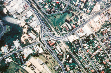
Slide - Photograph, Aerial Photo (c.1987): Main Road, Eltham from Pitt Street to Elsa Court, c.Aug. 1990
Part of a presentation, "Roads and Byways of the Shire of Eltham", by Russell Yeoman to the 12 September 1990 Society meeting. Slides shown included copies of old photos and recent images ranging from the suburban streets of Eltham and Montmorency to the mountain roads of Kinglake. In the byways category are views of some iof the Shire's bicycle paths including then recently completed sections of the Main Yarra Trail at Lower Plenty.35mm colour positive transparency (1 of 37) Mount - Agfachrome Agfa CS System black 8 dotsinfrastructure, roads, aerial photographs, alistair knox park, bridge street, central park, diamond street, elsa court, eltham, eltham common, eltham railway station, eltham town park, main road, pitt street -
 Eltham District Historical Society Inc
Slide - Photograph, Aerial Photo (c.1987): Main Road, Lower Plenty from Heidelberg Golf Course to Plenty River, c.Aug. 1990
Part of a presentation, "Roads and Byways of the Shire of Eltham", by Russell Yeoman to the 12 September 1990 Society meeting. Slides shown included copies of old photos and recent images ranging from the suburban streets of Eltham and Montmorency to the mountain roads of Kinglake. In the byways category are views of some iof the Shire's bicycle paths including then recently completed sections of the Main Yarra Trail at Lower Plenty.35mm colour positive transparency (1 of 37) Mount - Agfachrome Agfa CS System black 8 dotsinfrastructure, roads, aerial photographs, heidelberg golf club, lower plenty, lower plenty bridge, main road, plenty river -
 Eltham District Historical Society Inc
Slide - Photograph, Aerial Photo (c.1987): Sherbourne Road overpass, Briar Hill, c.Aug. 1990
Part of a presentation, "Roads and Byways of the Shire of Eltham", by Russell Yeoman to the 12 September 1990 Society meeting. Slides shown included copies of old photos and recent images ranging from the suburban streets of Eltham and Montmorency to the mountain roads of Kinglake. In the byways category are views of some iof the Shire's bicycle paths including then recently completed sections of the Main Yarra Trail at Lower Plenty.35mm colour positive transparency (1 of 37) Mount - Agfachrome Agfa CS System black 8 dotsinfrastructure, roads, aerial photographs, briar hill, overpass, para road, railway bridge, sherbourne road -
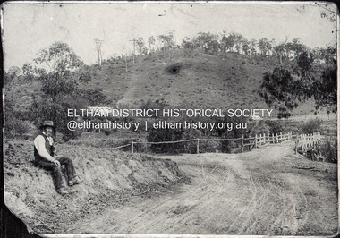 Eltham District Historical Society Inc
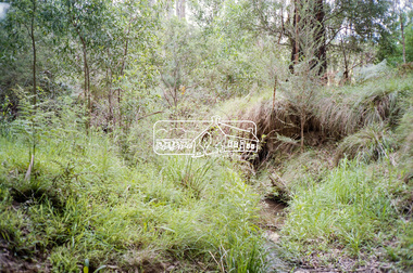
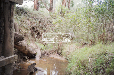
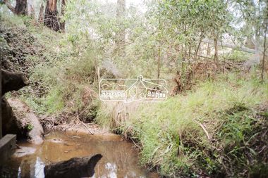
Negative - Photograph, Mr Belot smokes his pipe whilst resting at Cottle's Bridge, c.1990 (c.1890)
Copy of original photograph. The area, previously known as Back Creek, was named after Thomas Cottle, who settled in the district in the 1870s, and the original bridge over the Diamond Creek on the road to Strathewen. The original bridge (seen in the photo) was replaced with a new timber bridge at a cost of £1,500, the tender being awarded to a contractor named Birch who commenced work in June 1927. The gentleman in the photo who is resting whilst having a smoke of his pipe is a member of the Belot family.Roll of 35mm Black and White negative film, 3 strips, (1 of 14 frames)Film - Agfa Ortho 25belot, bridge, cottles bridge, cottles bridge-strathewan road, diamond creek (creek), heidelberg-kinglake road -
 Eltham District Historical Society Inc
Photograph, Construction of new bridge over the Plenty River, Main Road, Lower Plenty, c.Aug. 1966
Construction of the Main Road bridge over the Plenty River. Includes structural members, construction personnel, vehicles and a Clarke mobile crane.Local significanceBlack and white printlower plenty, main road, plenty river, bridge, bridge construction, civil engineering, cranes, mobile cranes -
 Eltham District Historical Society Inc
Slide, Maroondah Aqueduct, Research, Victoria, 22 Mar. 1981
An inspection tour of the Maroondah Aqueduct was undertaken by the Shire of Eltham Historical Society on Sunday, March 22nd, 1981, commening where the aqueduct crosses Main Rd., Research, just below Eltham College. The Maroondah Aqueduct was part of Melbourne’s water supply system. It carried water over the 66 km from the Maroondah Reservoir on the Watts River at Healesville to the Preston Reservoir. Of this length, 41 km were open channel, 10 km, tunnel through hills and 15 km in 14 inverted siphons across stream valleys. The route of the aqueduct is north of Tarrawarra and Yarra Glen, along the Yarra escarpment south of Christmas Hills and crossing Watsons Creek into the present Shire of Eltham near Henley Rd. The eastern part of the route lies entirely within the former boundaries of the shire. The aqueduct passes south of Kangaroo Ground to Research and crosses the Diamond Creek by siphon at Allendale Rd., Eltham North. It then extends to Reservoir via St. Helena, Greensborough North and Bundoora. Water first flowed through the aqueduct in February 1891 when it was fed by a diversion weir on the Watts River. Records of the building of the aqueduct indicate that it was a significant construction achievement. The present Maroondah Reservoir was completed in 1927 and the aqueduct was enlarged at that time to take increased flows. About 1971 the section of the aqueduct through and north of Research was replaced by a large pipe and that section of the channel is now unused. The channel has remained largely intact (unlike sections at Greensborough and Bundoora where long lengths of the disused aqueduct have been demolished or filled in). The M.M.B.W. relinquished control of the disused aqueduct reserve which is crown land and the Shire of Eltham took control of this section of the reserve as a linear park. The Maroondah Aqueduct is considered to be an important historic structure, not just to the local area but to the metropolitan area generally. It is considered important to preserve substantially intact long lengths of the disused aqueduct, together with its bridges and other associated structures. 35 mm colour positive transparency (1 of 5) Mount - Agfachrome Agfa CS System black 8 dotsactivities, heritage excursion, maroondah aqueduct, research (vic.), shire of eltham historical society -
 Eltham District Historical Society Inc
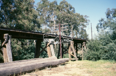
Slide - Photograph, Eltham Railway Trestle Bridge, c. 1988
35mm colour positive transparency Mount - Black and Whiteeltham trestle bridge -
 Eltham District Historical Society Inc
Slide - Photograph, Diamond Street Bridge, Eltham, c. 1988
35mm colour positive transparency Mount - Black and Whitediamond street bridge, eltham -
 Eltham District Historical Society Inc
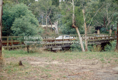
Slide - Photograph, Old Lower Plenty Bridge, c. 1988
35mm colour positive transparency Mount - Black and Whitelower plenty bridge -
 Eltham District Historical Society Inc
Slide - Photograph, Old Lower Plenty Bridge, c. 1988
35mm colour positive transparency Mount - Black and Whitelower plenty bridge -
 Eltham District Historical Society Inc
Slide - Photograph, Wingrove Park, Eltham, c.1992
35mm colour positive transparency Mount - Black and Whiteeltham south, main road bridge, wingrove park -
 Eltham District Historical Society Inc
Slide - Photograph, Main Road Bridge, Eltham South, c.1992
35mm colour positive transparency Mount - Black and Whitesignificant tree, antoinette boulevard, eltham, main road bridge -
 Eltham District Historical Society Inc
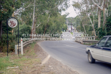
Slide - Photograph, Wattletree Road Bridge, Eltham, c.1992
35mm colour positive transparency Mount - Black and Whiteeltham, significant tree, infrastructure, roads, shire of eltham sign, sign, wattletree road bridge -
 Eltham District Historical Society Inc
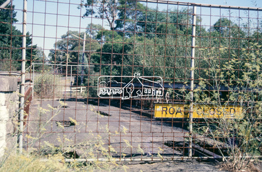
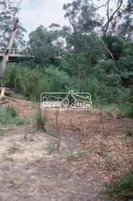
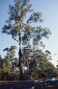
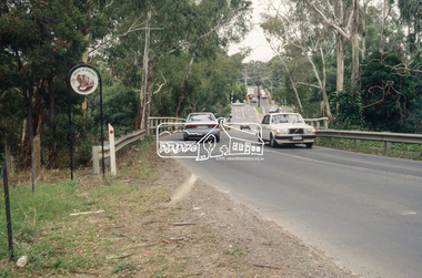
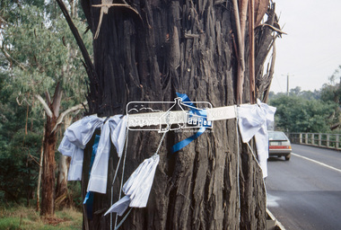
Slide - Photograph, World Environment Day 1993, Manna Gum, Main Road, Eltham South, 5 June 1993
World Environment Day was established by in 1972 by the United Nations General Assembly on the first day of the Stockholm Conference on the Human Environment. Two years later, in 1974 the first World Environment Day was held with the theme "Only One Earth" and is observed every year on June 5 to encourage awareness and environmental protection. According to United Nations, "The celebration of this day provides us with an opportunity to broaden the basis for an enlightened opinion and responsible conduct by individuals, enterprises, and communities in preserving and enhancing the environment." 35mm colour positive transparency (1 of 23) Mount - Black and Whiteantoinette boulevard, eltham south, heritage tree, main road bridge, manna gum, significant tree, world environment day 1993 -
 Eltham District Historical Society Inc
Slide - Photograph, Diamond Street Bridge, Eltham, c.1993
35mm colour positive transparency Mount - Black and Whiteinfrastructure, roads, eltham, diamond street bridge -
 Eltham District Historical Society Inc
Slide - Photograph, Wattletree Road Bridge, Eltham, c.1993
35mm colour positive transparency Mount - Black and Whiteinfrastructure, roads, eltham, eltham north, level crossing, main road, park west road, railway crossing, sign, wattletree road, wattletree road bridge