Showing 715 items matching " government printer melbourne"
-
 Port Melbourne Historical & Preservation Society
Book - Town of Port Melbourne, Contracts, 1900
Town of Port Melbourne contracts number 804 to 943 between 10.11.1903 and 20.09.1914. On inside cover details of printers and "No 89571 10.11.03"Contract Register, Town of Port Melbourne (on spine)local government - town of port melbourne -
Port Melbourne Historical & Preservation Society
Document - Report, Improvement of the Port of Melbourne, Improvement of the Port of Melbourne, 11 Jun 1855
... Ferres Government Printer ...Improvement of the Port of Melbourne -report upon the various plans for the improvement of Port of Melbourne, January 1854 Ten page foolscap on blue paper bound together with thread; .report by Capt C Paisley, Appendix and Particulars of Works by the Colonial Engineer, Lieut. H. Amsinck, RNmelbourne harbor trust - port of melbourne authority, piers and wharves, transport - railways, engineering - canals and drainage, port of melbourne, lieut h amsinck - colonial engineer, captain c paisley -
Port Melbourne Historical & Preservation Society
Document - Petition, To Parliament regarding the forming of the Borough of Sandridge, c. 1859
Printed copy of petition to Parliament as to forming Borough of Sandridge (mentions that original had 297 signatures) 1860local government - borough of sandridge -
Port Melbourne Historical & Preservation Society
Administrative Record - Agenda, Sandridge Borough Council, 18 Jan 1879
Business Agenda for Sandridge Borough Council meeting 1879local government - borough of sandridge, edward clark, town clerks -
Port Melbourne Historical & Preservation Society
Book - Town of Port Melbourne, Rates cash book, Arnell & Jackson, Printers, Manufacturing, Stationers, 1910 - 1914
Town of Port Melbourne. Rates cash Book. June 9th 1910 to June 4th 1914local government - town of port melbourne -
Port Melbourne Historical & Preservation Society
Document, A W Greig, "The Liardets of 'The Beach'", 1916
Article read before the Victorian Historical Society on 24th. November 1913. Published in The Victorian Historical Magazine, Volume 5, Number 1, March 1916"The Liardets of 'The Beach' " Greig's interview with Josephine Antoinette MacDONALD (nee LIARDET) forms the basis for this article on the history of the Liardet family.liardet family, josephine antoinette macdonald nee liardet, a w greig, lewis liardet, caroline salomie kucken -
Port Melbourne Historical & Preservation Society
Book - Town of Port Melbourne, financial reports, Arnell & Jackson, Printers, Manufacturing, Stationers, 1909 - 1919
A.09.03.DB Council of the Town of Port Melbourne - financial reports for the period 1908/09 to 1920local government - town of port melbourne -
Port Melbourne Historical & Preservation Society
Book - Borough of Sandridge, rate book, Mason and Firth, Printers, 1860 - 1864
Borough of Sandridge Rate Book - arrears of rates fee for the years 1860 to 1864local government - borough of sandridge -
Port Melbourne Historical & Preservation Society
Book - Town of Port Melbourne, Contract ledger, Arnell & Jackson, Printers, Manufacturing, Stationers, 1893 - 1902
Town of Port Melbourne - Contract ledger 1893 to 1902local government - town of port melbourne -
Port Melbourne Historical & Preservation Society
Book - Town of Port Melbourne, Loans Ledger, Arnell & Jackson, Printers, Manufacturing, Stationers, 1881 - 1893
Town of Port Melbourne, Loans ledger covering loan liability for 1881, 1887, 1893. Lagoon Act liability. Total Loan liabilities. Loans 1881,1887, 1893. Expenditure and bank account. 1881-1915local government - town of port melbourne, local government - borough of sandridge, local government - borough of port melbourne -
Port Melbourne Historical & Preservation Society
Certificate - David Jones and Mary Ann Harris, Colony of Victoria, Certificate of Marriage, 30 Apr 1870
Marriage Certificate for David Jones and Mary Ann Harris; married 30 April 1870 at Holy Trinity Church, Port Melbournereligion - anglican (holy trinity), celebrations fetes and exhibitions, david jones, mary ann harris -
Port Melbourne Historical & Preservation Society
Map, Port Melbourne Sheet 4, 1962
Framed line drawn map of Port Melbourne (sheet 4) 1962, covering the area from Beach Street (including Station and Princes Piers) to Plummer Street and Todd Road area to Dow Streetbuilt environment -
Port Melbourne Historical & Preservation Society
Map, Port Melbourne Sheet 1, 1962
Framed line drawing map of Port Melbourne (sheet 1) 1962, covering the area from Coode Canal to Plummer St and Todd rd to Boundary Stlocal government - city of port melbourne -
Port Melbourne Historical & Preservation Society
Functional object - Printing block, City of Port Melbourne, 1930s - 1940s
Steel printer's block of City of Port Melbourne insignia vintage 1930s? Image is reversed in solid 4cm squarebusiness and traders, local government - city of port melbourne, printing -
Port Melbourne Historical & Preservation Society
Document - Notice, Auction, Crown Lands, 1892
Auction notice of Crown lands, 1892town planning, land sales -
Port Melbourne Historical & Preservation Society
Booklet - Ministry for Planning and Environment, Urban Conservation Areas, Aug 1986
Ministry for Planning and Environment booklet of Urban Conservation Areas August 1986, detailing in words and sketches areas of inner Melbourne of special significance historically and architecturally, to be preserved. 16 pp, brown ink on cream paper.built environment, garden city, town planning, victorian ministry for planning and environment -
Port Melbourne Historical & Preservation Society
Booklet, Framework for the Future, Dec 1984
found in the Mayor's room at Port Melbourne Town Hall by Pat Grainger on the coffee table.Victoria - Central Melbourne: Framework for the Future No 6, Land Use and Development Strategy for the 1980stown planning -
Port Melbourne Historical & Preservation Society
Book - Port Melbourne Council, Arnell & Jackson, Printers, Manufacturing, Stationers, Dog Register, 1890 - 1901
Port Melbourne Council Dog registrations 1892 to 1901, with alphabetised index by surname of owner; with registration fee, breed, sex and age of dog recordedlocal government - town of port melbourne, domestic life, dogs -
Port Melbourne Historical & Preservation Society
Document - Report, Plan of General Development, Mr J Green (Government Printer), Plan of General Development, 1929
Plan of General Development. Melbourne Report of Metropolitan Town Planning Commission, 1929. Was passed on by local history librarian as it was no longer required. On p63 shows view up Swallow Street and contrasts it with approach of St Kilda. P42 aerial view of Port Melbourne piers. Also includes maps and photographs.town planning, piers and wharves, swallow street -
 Bendigo Historical Society Inc.
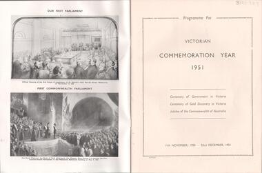
Magazine - LYDIA CHANCELLOR COLLECTION: VICTORIAN COMMEMORATION YEAR - 1951
A magazine titled ' Victorian Commemoration Year-1951.' It is a programme for the Centenary of Government in Victoria, Centenary of Gold Discovery in Victoria and the Jubilee of the Commonwealth of Australia. 11th November, 1950 - 23rd December, 1951. Victoria, J. J. Gourley, Govt. Printer, Melbourne.event, entertainment, centenary, lydia chancellor collection, collection, celebrations, victoria, gold discovery victoria, jubilee, government, australia, history -
 Bendigo Historical Society Inc.
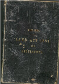
Book - VICTORIA LAND ACT 1884 AND REGULATIONS, 1885
Victoria Land Act 1884 with the Regulations Thereunder, 161 pages published Melbourne by the authority of John.Ferres, Government Printer 1885. Printed inside cover, Land Officer James Stirling Omeo 1.7.85victoria, history, land, victoria-history-land acts -
 Bendigo Historical Society Inc.
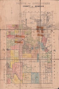
Map - JACK FLYNN COLLECTION: SHELBOURNE, 11/02/1937
Map: Parish of Shelbourne, County of Bendigo. Parish plan.By Authority, H. J.Green, Government Printer. Drawn and Reproduced at the Dept, of Lands and Survey, Melbourne, Victoria.map, bendigo, parish plan, shelbourne -
 Bendigo Historical Society Inc.
Map - JACK FLYNN COLLECTION: HAYANMI, March 1953
Map: Parish of Hayanmi, County of Bendigo. Parish plan.By Authority: W.M. Houston, Government Printer. Drawn and reproduced at the Dept, of Lands and Survey, Melbourne, Victoriamap, bendigo, parish plan, hayanmi -
 Bendigo Historical Society Inc.
Map - JACK FLYNN COLLECTION: ECHUCA NORTH, November 1953
Map: Echuca North, County of Rodney. Parish plan.By Authority: W.M. Houston, Government Printer. Drawn and Reproduced at the Dept., of Lands and Survey Melbourne, Victoria. November 1953map, rodney, parish plan, echuca north rodney -
 Bendigo Historical Society Inc.
Map - JACK FLYNN COLLECTION: BEALIBA, 15/09/1931
Map: Parish of Bealiba, County of Gladstone. Parish plan.By Authority H.J. Green, Government Printer. Photo Lithographed at the Government of Lands and Survey Melbourne. 15.9.31map, gladstone, parish plan, bealiba, gladstone -
 Bendigo Historical Society Inc.
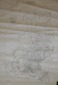
Map - JACK FLYNN COLLECTION: HUNTLY, August 1954
Map: Parish of Huntly, County of Bendigo. Parish plan.By Authority W.M. Houston, Government Printer. Drawn and Reproduced at the Dept, of Lands and Survey, Melbourne, Victoria. August 1954.map, bendigo, parish plan, huntly -
 Bendigo Historical Society Inc.
Map - JACK FLYNN COLLECTION: GOORNONG, August 1953
Map: Township of Goornong, Parish of Goornong, County of Bendigo. Parish plan.By Authority W.M. Houston. Government Printer. Drawn and Reproduced at the Dept., of Lands and Survey, Melbourne, Victoria. August 1953map, bendigo, township, goornong -
 Bendigo Historical Society Inc.
Map - JACK FLYNN COLLECTION: COUNTY OF GLADSTONE, 1934
Map: County of Gladstone, map sheet showing the whole of the County and the Parishes within. Scale 2 Miles to 1 inch.Engraved at the Department of Lands and Survey Melbourne. 1958. By Authority of W.M. Houston, Government Printermap, gladstone, parish plan, gladstone -
Bendigo Historical Society Inc.
Document - KELLY AND ALLSOP COLLECTION: PROMISSORY NOTES, 15/02/1896 to 03/06/1905
Document. KELLY & ALLSOP COLLECTION. Four promissory notes. [a] Dated 15 Feb 1896. Promise to pay Allsop & Co., 5 Pounds and 5 shillings at City Loan & Discount Office, Williamson St, Bendigo. Signed ? McMahon. [b] Dated 12 March 1903. Promise to pay Mr.Michael Kelly, 21 Pounds at Stock Exchange, Melbourne. Signed (undecipherable). [c] Dated 10 March 1904. Promise to pay Michael P.Kelly, 77 Pounds 10 shillings at Bendigo. Signed Alf Bailes. Handwritten in ink on back ''Lodged as collateral security 1 Watch & chain, 1 Bracelet, 5 Rings''. [d] Dated 3 June 1905. Promise to pay Michael P.Kelly, 20 Pounds at Commercial Bank, Bendigo. Signed Philip (?). Item [c] has Victorian Stamp Duty of 2 shillings. The other items has VSD of sixpence.Robt S.Brain, Government Printerbusiness, stockbroker, kelly & allsop, kelly & allsop collection, promissory note, alf bailes, mcmahon -
 Bendigo Historical Society Inc.
Book - BOOK: VICTORIA ACTS OF COUNCIL VOL. 1
Hardbound cardboard covered Book - Victoria Acts of Council Vol. 1 / first page shows 'Acts and Ordinances in force in Victoria. Edited by Travers Adamson, Esq., Barrister - at Law, Published by Authority. Melbourne; Printed by John Ferres, Government printer 1855, front cover missingorganisation, government, official, - victoria acts of council / edited by travers adamson , esq ., barrister - at law , published by authority . melbourne / ; printed by john ferres , government printer 1855