Showing 806 items
matching lake view
-
 Lakes Entrance Historical Society
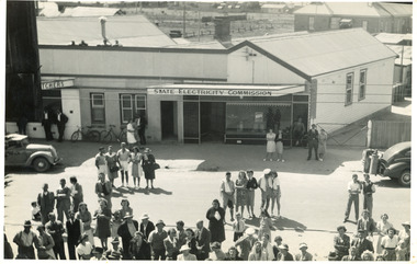
Photograph - State Electricity Office, 1944
This is the before paired photograph used in the 150 year, Lakes Entrance 1858-2008 display.|The after paired photograph number is 01424.1.|Also one 12 x 16 framed photograph used in room display.Black and white photograph of State Electricity Office, Esplanade, taken from Air Observers Spotting Tower on Esplanade. Photo taken on day of dedication of Tower in February 1944. In view is Stewarts Butcher shop, rear of Mechanics Hall. Crowd of people on road, two cars, one with gas producer of back, and bicycles. Lakes Entrance Victoriatownship, celebrations, transport, room display -
 Lakes Entrance Historical Society
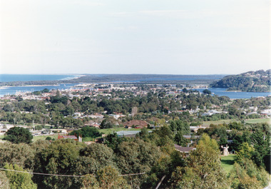
Photograph - Township, Tambo Shire, 1990c
Also second copy photographic enlargements of significant sites in the Tambo ShireColor photograph of the township, showing a distant view of the Ninety Mile Beach, the Gippsland Lakes and islands, Kalimna Heights, the bridge over the North Arm, Cunninghame Arm, and a broad view of the town and tree lined streets. Lakes Entrance Victoriabridges, topography, township, waterways -
 Lakes Entrance Historical Society
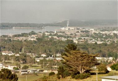
Photograph - Township, Fish Marie, 1985c
Colour photograph of township, showing building on Bullock Island, Cunningham Arm and small white shed on old New Works Jetty near the entrance, view towards the barrier. Photo taken from near telecom tower on Merrangbaur Hill 1985c. Lakes Entrance Victoriatopography, township, waterways, bridges -
 Lakes Entrance Historical Society
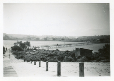
Photograph - Footbridge, Todd Della, 1945c
Black and white photograph of the footbridge over the Cunninghame Arm. It shows a sand covered wooden ramp leading from footbridge to ocean, shed in scrub covered southern shore, two people on bridge, distant view of town and trimmed memorial Cyprus trees. Lakes Entrance Victoriabridges, waterways -
 Marysville & District Historical Society
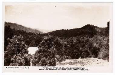
Postcard (Item) - Black and white postcard, Rose Stereograph Company, PANORAMA OVER MT. GRANT & LAKE MOUNTAIN FROM THE BALCONY OF GREEN LANES, MARYSVILLE, VIC, Unknown
A black and white postcard of the view of Mt. Grant and Lake Mountain from Green Lanes guest house in Marysville. The postcard was produced by the Rose Stereograph Company as a souvenir of Marysville.A black and white postcard of the view of Mt. Grant and Lake Mountain from Green Lanes guest house in Marysville. The postcard was produced by the Rose Stereograph Company as a souvenir of Marysville.F. Geoffrey Cobb Series No. 2 POST CARD The Rose Series/ De Luxe A Real Photograph/ Produced in Australia Published by the Rose Stereograph Co.,/ Armadale, Victoria.marysville, victoria, australia, greenlands, the spot, green lanes, sarah mclean, murdock mclean, geoffrey cobb, cath m anderson, mr and mrs a.g. clarke, e pigdon, bert patterson, guest house, postcard, souvenir, rose stereograph company, f geoffrey cobb, f geoffrey cobb series no. 2 -
 Port Melbourne Historical & Preservation Society
Photograph - Various photos related to John James GILCHRIST, John Gilcrist, 1940s - 1950s
From John Gilcrist via Janet Bolitho13 photos from John GILCHRIST showing his father, John James GILCHRIST, at Station Pier and Princes Pier, a view from the Shrine of Remembrance, Centenary Bridge, and his father and mother, Eileen Mary GILCHRIST at their home at 16 McCormack Street Port Melbourne .01 - Princes Pier, Taroona, Port Hobart .02 - View from Shrine overlooking Albert Park Lake .03 - Between piers .04 - Princes Pier at night .05 - From Station Pier West finger pier .06 - House at 16 McCormack Street. (No. 12 McCormack Street also shown) .07 - Centenary Bridge1949-50 .08 - Outside 16 McCormack Street, showing Singer car. (Nos. 22, 24 & 26 McCormack Street also shown) .09 - John and Eileen Gilcrist in backyard .10 - South side of house at 16 McCormack Street .11 - South side of house at 16 McCormack Street .12 - Photo of Edwards Park .13 - East side of house at 16 McCormack Street Refer also to hand drawn plan of house and outbuildings at catalogue no. 2763piers and wharves - station pier, piers and wharves - princes pier, built environment, transport - roads, mccormack street, john gilchrist, john james gilchrist, mary eileen gilchrist -
 Lakes Entrance Historical Society
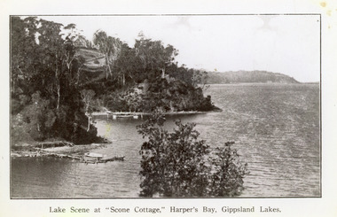
Photograph - Scone Cottage, 1920c
... Lakes. It shows rustic jetty in foreground with boat moored... by Mrs Westerson. Distant view of Jemmys Point. Lakes Entrance ...Copied from a postcardBlack and white photograph of Harpers Bight, Gippsland Lakes. It shows rustic jetty in foreground with boat moored, jetty below zigzag pathway to Cliff Crest Tea Rooms, a popular tourist venue, run by Mrs Westerson. Distant view of Jemmys Point. Lakes Entrance VictoriaLakes Scene at Scone Cottage, Harpers Bay, Gippsland Lakes tearoom, tourism, waterways -
 Lakes Entrance Historical Society
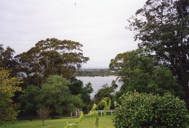
Photograph - Fraser Island, Holding M, 2000c
Colour photograph taken from the veranda of Nyerimilang Homestead, Gippsland Lakes. It shows a glimpse of Fraser Island through the trees and ornamental shrubs of the homestead garden. Fence and pathway to viewing platform in centre foreground. Lakes Entrance Victoriaislands, historic site -
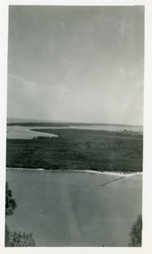
 Lakes Entrance Historical Society
Photograph - Rigby Island, 1950c
Two other copies 6 x 9 (one - slightly different view)Small format photograph of view from Kalimna across Rigby Island to back lakes near Lakes Entrance, Victoriaislands, waterways, topography -
 Lakes Entrance Historical Society
Photograph - Rigby Island, 1950c
Black and white photograph of view from Kalimna across Rigby Island to back lakes near Lakes Entrance, Victoriaislands, waterways, topography -
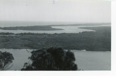 Lakes Entrance Historical Society
Photograph - Rigby Island, 1950c
Two other copies 6 x 9 (one - slightly different view)Small format photograph of view from Kalimna across Rigby Island to back lakes near Lakes Entrance, Victoriaislands, waterways, topography -
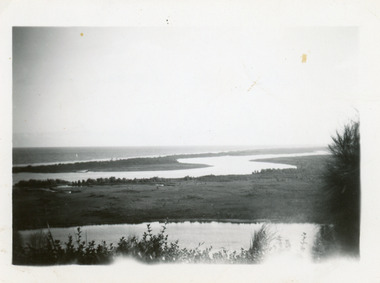 Lakes Entrance Historical Society
Photograph - Rigby Island, 1950c
Two other copies 6 x 9 (one - slightly different view)Small format photograph of view from Kalimna across Rigby Island to back lakes near Lakes Entrance, Victoriaislands, waterways, topography -
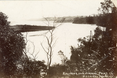 Lakes Entrance Historical Society
Postcard - Reeves Channel, Caire Nicholas John, 1905c
Also black and white enlargement 16 x 25Black and white postcard of the lake below Jemmys Point, Gippsland Lakes, showing Rigby Island opposite the steep cliffs of Kalimna and Nungurner shores of lakes. Small island, known as the Doughboy of Rigby Island. View taken from Jemmys Point with natural vegetation in foreground. Lakes Entrance VictoriaKalimna from Jimmys Pointislands, waterways, topography, boats and boating -
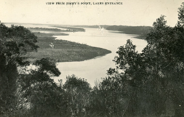 Lakes Entrance Historical Society
Postcard - Gippsland Lakes, Bulmer and Segerberg, 1915c
... View from Jimmy's Point Lakes Entrance...Islands Waterways Topography View from Jimmy's Point Lakes ...Black and white postcard of the Gippsland lakes, taken from Jemmys Point. It shows Rigby Island, Fraser Island and Flannagan Island, Reeves Channel. Natural vegetation in foreground. Lakes Entrance VictoriaView from Jimmy's Point Lakes Entranceislands, waterways, topography -
 Lakes Entrance Historical Society
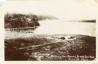
Postcard - Maringa Creek, Caire Nicholas John, 1900c
Also three black and white copies 17 x 25First generation black and white postcard of the Kalimna area of the Gippsland Lakes. It shows a residence surrounded by a paling fence at Maringa Creek in foreground, dead vegetation at mouth of creek. Steep cliffs of lake shore opposite low lying Rigby Island. Lakes Entrance VictoriaKalimna and Reeves River. Gen View.waterways, topography -
 Lakes Entrance Historical Society
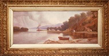
Photograph - Maringa Creek, 1997c
Walter Seehusan, first art teacher at Bairnsdale School of Mines. Painting in possession of St Nicholas Anglican Church, Lakes Entrance, Victoria, bequeathed by Miss E L Phillips. Original painting 1890c.Colour photograph of a painting by W Seehusan of view from site of Kalimna Jetty towards Nungurner, showing mill workers cottages, jetty and steamers at Maringa Creek sawmill. Fisherman's cottage in right foreground, settlement at Maringa Creek, Gippsland Lakes, by mill workers and fishermen. Painting shows denuded cliffs and timber slide. Lakes Entrance Victoriawaterways, boats and boating, settlement -
 Lakes Entrance Historical Society
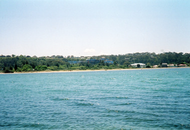
Photograph - Kalimna, Davies, Judy, 2005c
Colour photograph of a distant view of Kalimna Heights and the western end, across the waters of Cunninghame Arm. Shows the recently constructed tourist complex behind the Club Spit and other buildings on Esplanade. Lakes Entrance Victoriawaterways, township -
 Lakes Entrance Historical Society
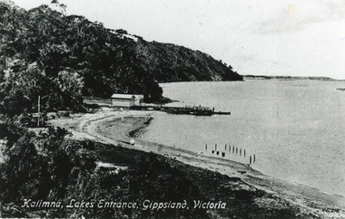
Photograph - Kalimna Jetty, Valentine Series, 1915c
Black and white photograph of the lake shore at Kalimna, showing Kalimna jetty and storage shed, low sandy shore in foreground contrasting with steep cliffs beyond jetty. Indistinct distant view of New Works area at southern shore of Cunninghame Arm. Lakes Entrance VictoriaKalimna Lakes Entrance Gippsland Victoriajetties, waterways -
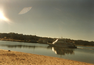
 Lakes Entrance Historical Society
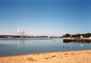
Photograph - Thunderbird, Holding M, 2000c
Colour photograph of the township viewed from the southern shore of Cunninghame Arm at the New Works. New Works Jetty in mid foreground, tourist launch Thunderbird on lake. Smoke from a bushfire in distance. Reflections in calm waters of lake. Lakes Entrance Victoria tourism, waterways, township, boats and boating -
 Lakes Entrance Historical Society
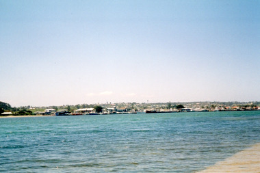
Photograph - Lakes Entrance, Davies, Judy, 2005c
Colour photograph of the township viewed across the Cunninghame Arm from the New Works area. Lakes Entrance Victoriawaterways, township -
 Lakes Entrance Historical Society
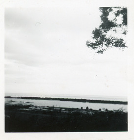
Photograph - Cunninghame Arm, Fraser, Nancy, 1970c
Black and white photograph of a distant view township and Cunninghame Arm and scrub covered hummocks of southern shore in distance. Lakes Entrance Victoria topography, waterways -
 Lakes Entrance Historical Society
Photograph - Thunderbird, 1998c
Colour photograph of the Thunderbird, tourist launch passing Bullock Island. Lakes Entrance fishing Co-Operative in view on Bullock Island, dredged sand in foreground. Lakes Entrance Victoriaislands, tourism, boats and boating -
 Lakes Entrance Historical Society
Photograph - New Works, Phillips, Miss L, 1900c
Also other black and white copy 9 x 14 cm, donated by Russell Goff with inscription The TownSepia photograph showing view from the dunes across lake, and Cunninghame Arm, to township. Foreground shows dense vegetation on dunes behind two houses, harbour engineer's house on left and contractor John Carpenter's house on right. Lakes Entrance Victoriawaterways, township, boats and boating, topography -
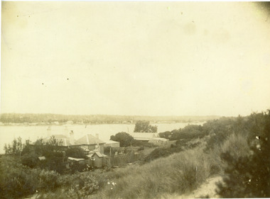
 Lakes Entrance Historical Society
Photograph - New Works, 1905c
Also black and white copy 10 x 16.5|Also sepia toned postcard damagedBlack and white photograph showing view from New Works across lake, and Cunninghame Arm. Foreground shows two children on boardwalk, roofs of harbour masters and harbour engineers houses, and the house of the contractor John Carpenter. Smoke billowing from funnel of S S Wyralla. Lakes Entrance Victoriajetties, waterways, township, topography -
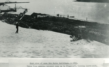 Lakes Entrance Historical Society
Photograph - New Works, 1895c
Photo taken from approx present ramp up to flagstaff, looking north-westBlack and white photograph showing view from top of hummocks overlooking New Works buildings. North end of eastern pier on left, Cunninghame Arm in front of building. Lakes Entrance VictoriaRear view of some New Works buildings 1895cjetties, waterfront, historic buildings -
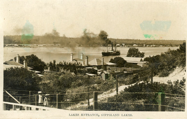
 Lakes Entrance Historical Society
Photograph - The Entrance, 1924c
Black and white photograph showing view from Jemmys Point of the entrance, with wooden piers, PWD houses and works buildings at New Works. West end of Bullock Island on left side of photo, bathing boxes and some trees on island, some rock groyne work at the entrance. Lakes Entrance Victoriapiers, islands, houses -
 Lakes Entrance Historical Society
Postcard - Backwater, Bulmer H D, 1922c
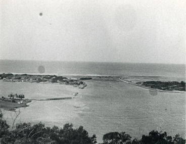
... view of township of Lakes Entrance, Cunninghame Arm, North Arm... photographic postcard, showing early aerial view of township of Lakes ...Black and white photographic postcard, showing early aerial view of township of Lakes Entrance, Cunninghame Arm, North Arm and sand dunes, ocean in lower foreground, Eastern wharf and various boats on lake. Princes Highway went along Esplanade, Myer Street and Roadknight Street, very little vegetation on sand dunes, no foot bridge yet, good view of North Arm, few houses. Lakes Entrance VictoriaLakes Entrance and Backwater from the Air.islands, aerial photograph, waterways, topography, township -
 Lakes Entrance Historical Society
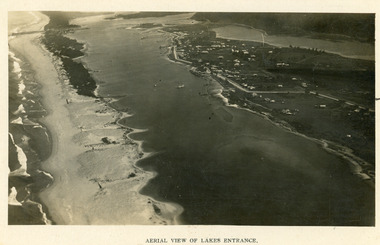
Photograph - Lakes Entrance, 1923c
... Black and white photograph showing early aerial view...Aerial View of Lakes Entrance... Photograph Islands Township Aerial View of Lakes Entrance Black ...Two copies 16.5 x 25.5 very darkBlack and white photograph showing early aerial view of township of Lakes Entrance, photo shows highway going along Myer Street and along Roadknight Street, no shops in Myer Street appears to be no foot bridge, therefore taken prior to 1937, sparce vegetation on foreground dunes, four barriers built on dunes to stop erosion through sand, two masted sailing boat in lake. Bullock Island in distance appears very small, Snake Island of Rigby Island in centre distance. Lakes Entrance VictoriaAerial View of Lakes Entrancewaterways, coast, aerial photograph, islands, township -
 Lakes Entrance Historical Society
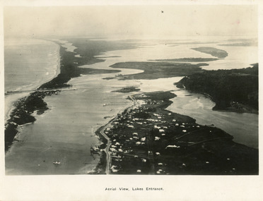
Postcard - Lakes Entrance, 1923c
... , and a distant view of Boole Poole, Bunga Arm and Lake King. Lakes...An aerial view showing position of Lakes Entrance... of Lakes Entrance Black and white postcard of an aerial view ...Also large postcard 15 x 20|Also two mini postcard 6 x 9|Also copy black and white 9 x 14.5Black and white postcard of an aerial view of township of Lakes Entrance, showing western end of town, jetties and boat harbours in Cunninghame Arm, the entrance and piers, North Arm bridge, Bullock Island, Rigby, Fraser and Flannegan Islands, and a distant view of Boole Poole, Bunga Arm and Lake King. Lakes Entrance VictoriaAn aerial view showing position of Lakes Entranceaerial photograph, islands, waterways, topography, township -
 Lakes Entrance Historical Society
Photograph - Foreshore Lakes Entrance, Bulmer H D, 1923c
Second copyBlack and white photograph showing aerial view of the entrance to the Gippsland Lakes, shows Cunninghame Arm, North Arm, Reeves River and Hopetoun Channel, Rigby Island and Snake Island, the barrier on right foreground. Lakes Entrance Victoriawaterways, islands, aerial photograph, fishing industry, coast