Showing 3659 items
matching landscaping
-
 Victorian Interpretive Projects Inc.
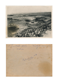
Photograph - digital, Turkish Kitchen in Action During World War One, 1918
Black and white photograph of a landscape where Turkish soldiers are in action during World War One. Verso: A Turkish photo. Turkish mounted men in action. Palestine 1918world war, world war one, turks, turkish, horses, mmm -
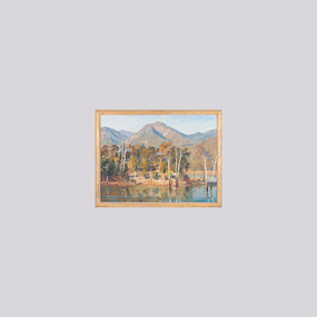
 Benalla Art Gallery
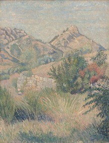
Painting, Lucien PISSARRO, Mt Tourris, Toulon, 1939
Born: Paris, France 1836; Died: London, England 1944ImpressionismLedger Bequest, 1993Rural landscape with stonewall, trees and mountains. Cream, green, gold and blue wood moulding frame.Recto: Signed with a monogram in blue paint l.r.c of composition; Dated 1939; Not titledlandscape, trees, mountains, pastoral, stone wall, europe -
 Benalla Art Gallery
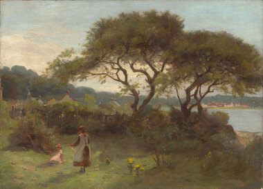
Painting, UNKNOWN, Untitled, 1885
Born: Dorchester, Dorset, England 1856; Arrived: Melbourne, Victoria, Australia 1869; Lived and worked: Spain, England, France 1883-1885; Died: Kallista, Victoria, Australia 1931ImpressionismGift of Wooleen Pty. Ltd., 1980Seaside Landscape with small figures playing and trees, water, grass, flowers and buildings in the distance. Unframed.Recto: Signed and dated "Tom Roberts / 1888" in mauve oil in l.r.c of composition; Not titledpainting, landscape, trees, figures, buildings, colonial, children, flowers -
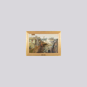
 Benalla Art Gallery
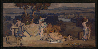
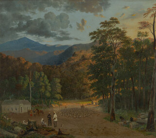
Painting, Arthur STREETON, Pastoral design, 1912
Born: Mount Duneed, Victoria, Australia 1867; Lived and workd: England 1897-1919; Died: Olinda, Victoria, Australia 1943EdwardianGift of Wooleen Pty. Ltd., 1980Rural landscape with architectural form and figures naked and partially clothed. Gilded bronze timber frame.Recto: Signed "A. STREETON" in burgandy oil r.l.c of composition; Not dated; Not titledpainting, landscape, figures, nude, river, grecian, tree, animals -
 Benalla Art Gallery
Painting, H. L. VAN DEN HOUTEN, Marysville Courthouse, Not dated
Born: The Hague, Netherlands 1801; Arrived: Melbourne, Victoria, Australia 1853; Died: Melbourne, Victoria, Australia 1879VictorianGift of Wooleen Pty. Ltd., 1980Rural colonial forested landscape with animals, figures trees and mountains. Gold brushed timber frame.Recto: Signed "H.L.V.d.Houten / [illegible]" in brown oil in l.r.c of composition; Not dated; Not titledpainting, landscape, trees, figures, animals, buildings, mountains, colonial, horse, dog -
 Robin Boyd Foundation
Slide, Robin Boyd, 1967
Robin Boyd was appointed Exhibits Architect for the Australian Pavilion at Expo ‘67 in Montreal. The garden outside the pavilion featured a sculptural pool, a coral display, animal pool, a pit for kangaroos and Eucalypts and other native plants. The indoor exhibits covered aspects of Australian art and culture, architecture, industrial design and scientific innovation, such as the Snowy Mountains Hydro-Electric Power Scheme, the Parkes radio telescope, the design of Canberra, and the Australian way of life.Colour slide in a mount. Landscape, unknown location, possibly Montreal, Canada (see also S1226)Made in Australia / 5 / MAY 67M6expo 67, montreal, robin boyd, slide -
 Robin Boyd Foundation
Slide, Robin Boyd, 1967
Colour slide in a mount. Landscape, unknown location, possibly Montreal, Canada (see also S0094)Made in Australia / 6 / MAY 67M6slide, robin boyd -
 Robin Boyd Foundation
Slide, Robin Boyd, 1966
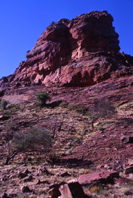
Robin Boyd was appointed Exhibits Architect for the Australian Pavilion at Expo ‘67 in Montreal. In 1966 Boyd travelled to Far North Queensland and the Northern Territory for research – the Expo exhibits included a coral display, a large rock feature made from Australian sandstone and a native plant garden.Colour slide in a mount. Rocky landscape, when visiting Alice Springs, Northern Territory, Australia.Made in Australia / 17 / DEC 66M4 / Encircled 5 (Handwritten)northern territory, slide -
 Lakes Entrance Regional Historical Society (operating as Lakes Entrance History Centre & Museum)
Photograph, L E Tidy Town Committee, 1994 c
Also a colour photograph of progress on tourist jetty forecourt 05156.1 10 x 15 cmColour photograph showing landscaping in progress at forecourt of tourist jetty Esplanade Lakes Entrance Victoriawaterways, dredging -
Clunes Museum
Painting
THE PAINTING WAS DONE BY MRS. HOLY BARKELLSEPIA TONED LANDSCAPE MOUNTING BOARD MARKED THE MOUNT ROAD CLUNES. BROWN WOODEN FRAMElocal history, illustration, oil, barkell, harris family. -
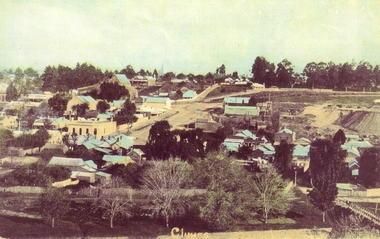 Clunes Museum
Photograph
HAND COLOURED POSTCARD PHOTOGRAPH OF CLUNES LANDSCAPE FROM NORTH CLUNES - NOW THE SCENIC ROADlocal history, photography, photographs, clunes landscape, buildings -
 Wangaratta Art Gallery
Painting, John Colin Angus, North East Pastoral, 1984
Rural City of Wangaratta CollectionA pastoral landscape painting in oil using a tonal colour palette of greens, blues, browns and yellows.J. Colin Angus/ 84/ (bottom left corner)wangaratta art gallery, j colin angus, john colin angus, painting, landscape, pastoral -
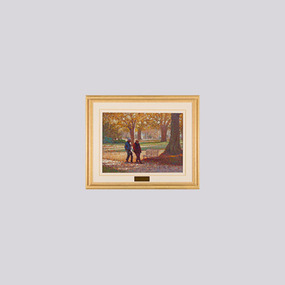 Wangaratta Art Gallery
Painting, Do Noble, Autumn Lovers, c. 2004
Rural City of Wangaratta Collection, Wangaratta Art Show 2004.A landscape scene of an elderly couple walking through a park in Autumn painted in a post-impressionist style.Obverse: DO NOBLE/ (bottom right corner) 2004 Art Show/ - Grand Winner - / 'Autumn Lovers' - By Do Noble/ Judge Ramon Horsfield/ (plaque on mounting board)wangaratta art gallery, do noble, painting, autumn, landscape -
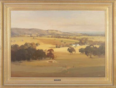 Wangaratta Art Gallery
Painting, Ross Paterson, Morning, near Euroa, 1985
Rural City of Wangaratta Collection. Wangaratta Art Show Grand Winner 1985.A landscape of a pastoral scene, painted in oil using shades o green, brown, blue, and yellow.R Paterson '85/ (bottom right corner) - GRAND WINNER 1985 -/ WANGARATTA ART SHOW/ (plaque mounted on frame)wangaratta art gallery, ross paterson, landscape, painting pastoral -
 Wangaratta Art Gallery
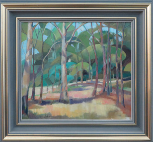
Painting, Rodney Symmons, Lake Buffalo, 1998
Rural City of Wangaratta Collection. Wangaratta Art Show - Grand Winner 1998.A oil landscape of Lake Buffalo, painted using shades of blue, green, yellow, brown, and white.Obverse: R SYMMONS/ (bottom right corner)wangaratta art gallery, rodney symmons, landscape, painting, lake buffalo -
 Wangaratta Art Gallery
Painting, Kevin Taylor, Winter's Cloak Mordialloc, c. 2000
Rural City of Wangaratta Collection. Wangaratta Art Prize Grand Winner 2000.A coastal landscape of docked boats painted in oils using shades of green, yellow, brown, and grey.Obverse: Taylor (bottom right corner)/ Grand Winner 2000/ WINTERS CLOAK MORDIALLOC/ By KEVIN A. TAYLOR/ Judge - Ms. JUDITH GARDE/ (plaque mounted on frame)wangaratta art gallery, kevin taylor, landscape, painting, coastal, boats, dock -
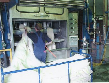 Stawell Historical Society Inc
Photograph - Aunde Album 29, Milling, 2002
Aunde / Norwellan Textiles North Western Woolen Mills became Norwellan Textiles then AUNDEColour landscape photo: Male worker inserting / extracting blanket into milling machine. Trolly with blanketsMillingindustry, aunde -
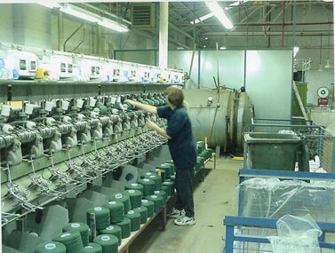 Stawell Historical Society Inc
Photograph - Aunde Album 29, Winding, 2002
Aunde / Norwellan Textiles North Western Woolen Mills became Norwellan Textiles then AUNDEColour landscape photo: Female worker loading yarn into /onto winding machine - wheeled crateswindingindustry, aunde -
Whitehorse Historical Society Inc.
Article, Heritage or heresy, 1/12/1993 12:00:00 AM
Article on the management plan for Schwerkolt Cottage being prepared for Nunawading Council by Landscape Australia consultants.Article on the management plan for Schwerkolt Cottage being prepared for Nunawading Council by Landscape Australia consultants.Article on the management plan for Schwerkolt Cottage being prepared for Nunawading Council by Landscape Australia consultants.schwerkolt cottage, city of nunawading, gray, bill, cox, george, landscape australia consultants -
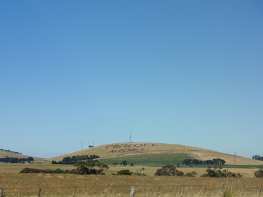 Ballarat Heritage Services
Plaque, Piss Off Ausnet, Mt Prospect
Angry farmers protest Angry farmers protest against huge power transmission land which will destroy pristine views and make some agricultural land unusable. A rural landscape at Mt Prospect on which has been plouhed the words 'Piss Off Ausnet"piss off ausnet, newlyn, mt prospect -
Moorabbin Air Museum
Booklet (Item) - US Aircraft Identification Booklet, Aircraft Recognition for the Ground Observer
Designed to assist the US and Canadian Ground Observer Corps as well as enthusiasts. -
 Ballarat Tramway Museum
Book, Keith Kings, "Bendigo's Vintage Talking Trams"
Book - "Bendigo's Vintage Talking Trams" - Edited by Keith Kings tells the story of Bendigo's trams from the battery tram days through to the operation by the Bendigo Trust. Includes the script of the Talking tram (Nov. 1996) and the tram fleet at the time. Has a table of contents, editor's notes and a colour map of the trip with script or talking points.Yields information about Bendigo's trams and that of the Bendigo Trust operations and fleet.Book - A5 landscape, 100 pages + card covers centre stapled, with some colour pages.bendigo, musuems, bendigo trust, keith kings, trams, tramways -
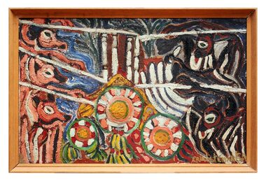 The Dunmoochin Foundation
Oil Painting, Untitled (Flowers), 1969
Painting depicting a landscape with three central flowers and three dingoes to the left and two bats to the right. Signed (L.r) 'Eric Stewart 69'.eric stewart, painting, landscape, flower, dingo, bat -
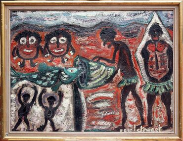 The Dunmoochin Foundation
Oil Painting, Legend of Wur-run-nah's Walkabout, No Date
Thick impasto painting depicting six figures; two indigenous males catching a fish in a landscape.Signed (L.r) 'Eric L. Stewart'. On Reverse: 'Legend of Wur-run-nah's walkabout by Katherine Stow (later Mrs. k.L. Parker). Wurrunnah when in a strange country, saw little round men who live in water. They made a coolomon of bark to keep the fig flies from him. Caught fish which were thrown up by the little water men'.eric stewart, painting, landscape, indigenous male, fish -
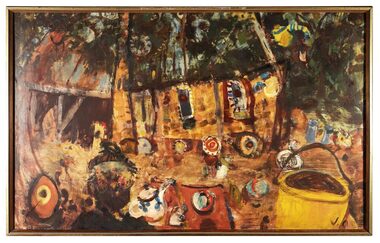 The Dunmoochin Foundation
Oil Painting, Peter Laycock Pottery, 1969
Painting depicting a building in the landscape with central figure holding a teapot surrounded by numerous pieces of pottery. Signed (L.r) 'J.O.' On reverse in chalk ' Peter Laycock Pottery, Dunmoochin, 1969, John Olsen'. john olsen, painting, landscape, peter laycock, pottery, dunmoochin -
 The Dunmoochin Foundation
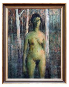
Oil Painting, Marlene (Standing Nude), 1963
Painting depicting a female nude with dark hair standing in a landscape with lake and three white trees. Signed and dated lower right 'Clifton '63'.clifton pugh, painting, portrait, landscape, marlene, female nude -
 Federation University Art Collection
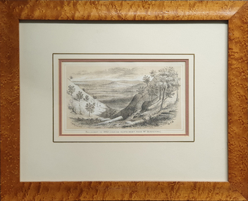
Work on paper - Lithograph, Ballarat in 1852.(Looking North West from Mt Buninyong), 1887
This item is part of the Federation University Art Collection. The Art Collection features over 2000 works and was listed as a 'Ballarat Treasure' in 2007.Framed chromo-lithograph depicting a landscape with deep slopes. The lithograph is from Withers 'History of Ballarat'.art, artwork, s.t. gill, samuel thomas gill, f.w. niven, buninyong, ballarat, landscape, available -
 Federation University Art Collection
Painting - oil on masonite, David Alexander, Along Creswick Road, c1965
Creswick Road is in Ballarat.A painting of a landscape along Creswick Road, Ballarat by David Alexander. Gift of David Alexander, 2013Signed in ink lower left corner 'Along Creswick Road About 1965. D. Alexander'creswick road, ballarat, art, artist, david alexander, available -
University of Melbourne, Burnley Campus Archives
Plan, Landscape Construction, 1960-1990
Miscellaneous plans on tracing paper and paper related mainly to Landscape Construction (approx. 40 sheets)landscape construction -
University of Melbourne, Burnley Campus Archives
Plan, Landscape Concept Plan Arboriculture & Amenity Building Courtyard and Entrance, 1995
Photocopy of plan by ACM Landscape Architecture for VCAH Burnley, Vic. November 1995 Dwg L2.vcah, burnley campus