Showing 1777 items
matching maps and plans
-
 Bendigo Historical Society Inc.
Map - CAMPBELL COLLECTION: BENDIGO AND DISTRICT MAPS, 1982
Map. Forest Commission Victoria, Bendigo Forest District, Sub-Plan 1 District Fire Prevention Plan, Greater Bendigo Area. Prevention Strategy Plan. Shire of Marong, Shire of Huntly, Borough of Eaglehawk, Shire of Strathfieldsaye, Sailors Gully, Epsom, Jackass Flat, White Hills, California Gully, Maiden Gully, Long Gully, North Bendigo, City of Bendigo, Bendigo East, Kennington, West Bendigo, Golden Square, Quarry Hill, Flora Hill, Spring Gully, Kangaroo Flat.Base prepared 1982. (number 397 in map cupboard 1)map, bendigo, forest district -
 Bendigo Historical Society Inc.
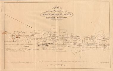
Document - MARKS COLLECTION: ABE LINCOLN CO LEASE
Two copies of plan for Abe Lincoln Co. Lease, New Chum, Sandhurst. One original, one copy. On top of plan 'Plan Showing Position of the Abe Lincoln Co. Lease, New Chum, Sandhurst' under name 'by H.B. Nicholas, Mining Surveyor' Sheepshead Reef, Easter reef, Alfred Reef, Allingham Reef,Adventure Reef, Belle Vue Reef, New Chum Reef, Black Lead, Victoria Reef lines shown on map with mine leases marked. On bottom of map 'Monument Hill Reef' line marked.bendigo, mining, abe lincoln lease -
 Bendigo Historical Society Inc.
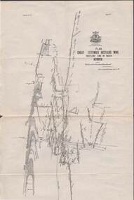
Map - STRUGNELL COLLECTION: HUSTLER'S LINE OF REEFS, BENDIGO, September 1913
Map, Hustler's Line of Reefs, Great Extended Hustler's Mine Plan, Plate No. X1 (11). Bulletin No 33 Signed H.A.Whitelaw Underground survey Office Bendigo September 1913.Underground Survey Office, Bendigo.map, bendigo, great extended hustler's mine -
 Bendigo Historical Society Inc.
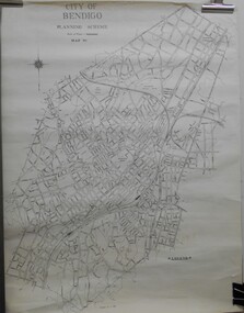
Map - JACK FLYNN COLLECTION: BENDIGO, Revised 1/01/1961
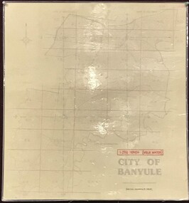
Map: Bendigo city, it has City of Bendigo Planning Scheme as the title. Showing the city within the Municipal Boundaries, also has contour lines and the Major Gullies. Revised 1.1.1962.map, bendigo, city streets, bendigo planning scheme -
Bendigo Historical Society Inc.
Map - BENDIGO (PART), No date visible
Map: Portion of Bendigo parish plan, showing from Murphy St. East to Bob St and between rail line to old saleyards to the old Heathcote line Canvas backed.map, bendigo, city streets, bendig parish plan , bendigo city streets -
 Whitehorse Historical Society Inc.
Legal record - Document, Melbourne Metropolitan Planning Scheme, 1987
Explanatory Statement of Amendment 500 to Melbourne Metropolitan Planning Scheme, including map of area (South of Blackburn Station). To be exhibited from 2 October 1987 to 22 December 1987.roads and streets, victoria. ministry for planning and environment, city of nunawading, south parade, blackburn, blackburn road, blackburn, main street, blackburn -
Bendigo Historical Society Inc.
Map - CAMPBELL COLLECTION: BENDIGO & DISTRICT MAPS, 21-8-1972
Map. Strathfieldsaye. Locality Plan, Scale 1 inch, also marked are : Shire of Huntly, Shire of McIvor, Shire of Metcalfe, Shire of Maldon, Shire of Marong, City of Bendigo, Lake Eppalock, and various lanes and roads. Mileage on some roads. (number 370 in map cupboard 1)M.Higgsmap, bendigo, rural -
Federation University Historical Collection
Booklet, Ballarat School of Mines Botanical Gardens Conservation/Restoration Management Plan
A Conservation/Restoration Management Plan for the Ballarat School of Mines Botanical Gardens. The report includes a planting timeline of the plants included in the gardens from 1850. Historical plans and maps are detailed from 1857 up to the site assessment in 2008.Printed report stapled at top left corner.Lisa Palmer written at top right corner in pencil.smb, school of mines ballarat, ballarat school of mines, botanical gardens, smb botanical gardens, conservation, restoration, ballarat school of mines garden, von mueller garden, ferdinand von mueller, botany, living collections, horticulture, gardens -
 Greensborough Historical Society
Map, Banyule City Council, MMBW, 1:2500 Series. City of Banyule. Master overlay, 1994_
This master overlay is the key to the Melbourne and Metropolitan Board of Works maps: MMBW, 1:2500 Series. The overlay was made by the City of Banyule using the Melways base plan (Edition 23, 1994-95). This overlay can be used to position maps in this series.Laminated map, with overlay of MMBW map grid.mmbw, melbourne and metropolitan board of works, banyule city council -
 Bendigo Historical Society Inc.
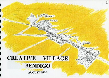
Book - MERLE HALL COLLECTION: ROSALIND PARK CREATIVE VILLAGE BENDIGO PROJECT BOOK, 1995
Merle Hall Collection: Rosalind Park Creative Village Bendigo Project Book. August 1995 Book contains a description, aims of the programme and a linking plan. 35 Pages: Cover Intoduction, The Design Team, Acknowledgement Project Brief Map of Linked Park The Linking Plan described Linking plan graphic Golden Beacon Design Concept Bridge Beacon Entrance to Linear Park Gasworks Café Pavillion Gasworks layout plan Golden Beacons Concept Botanical Gardens Café Botanical Gardens layout plan Victoria Hill Interpretation Centre Victoria Hill layout Victoria Hill plan Victoria Hill continued Victoria Hill continued Rosalind Park Lookout Method 3D Road Map 3D Road Map Continued Implementation Community Participation Oppurtunities, Mosaic Works Appropriate sites Appropriate sites continued Consultaion Summary and Issues Ideas Areas for further consideration Graphic The Design Team - Grant Fink, Jane Marriott, Laszo Biro, James Brearley Graphic Layoutbook -
 Bacchus Marsh & District Historical Society
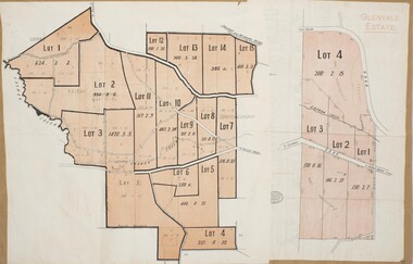
Map, Glenvale Estate and Glenmore Estate Land Sales 1909
The two land auction plans shown in this record relate to the sale of land from the Glenmore Estate property. The Glenmore property was established by C.J. (Charles James) Griffith and James Moore around 1840. Moore sold his interest to Moelesworth Greene in 1848. Greene was the nephew of the other owner Charles Griffith who died in 1863. From around the 1870s onwards parts of the Estate were subdivided and put up for sale or lease. In subsequent decades more changes in ownership occurred. These two plans document another major sale of the land from the original Glenmore Estate including part of the estate which had become used for dairy farming and was at that time known as the Glenvale Estate. Two single page maps pasted together on a single page of a bound volume of maps. One map shows 15 separate lots of land for sale. The other map which has the words 'Glenvale Estate' at the top of the map shows 4 lots of land for sale. Both parcels of land were originally part of the Glenmore Estate a pastoral holding belonging to C.J. Griffith and James Moore which the began in the Rowsley area south west of Bacchus Marsh in the 1840s. The maps are pasted into a bound volume containing 76 maps or plans in total. High resolution digital image stored on BMDHS computer network. bacchus marsh victoria maps, glenvale estate property, glenvale estate land sales, glenmore estate, glenmore station -
 Bendigo Historical Society Inc.
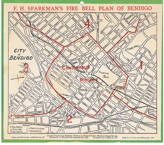
Document - FIRE BELL PLAN OF BENDIGO
Plan Document. A Fire Bell Plan of Bendigo issued by F.H.Sparkman. A street map of Bendigo split up into a central zone plus four surrounding zones. It is probably the upper part of a calendar with the date section missing (torn off). F.H.Sparkman was a printer and a Mason. Date not shown but probably prior to 1950F.H.Sparkmanessential services, firefighting, fire bell plan of bendigo, fire bell plan, f.h.sparkman -
Port Melbourne Historical & Preservation Society
Document - Report, Plan of General Development, Mr J Green (Government Printer), Plan of General Development, 1929
Plan of General Development. Melbourne Report of Metropolitan Town Planning Commission, 1929. Was passed on by local history librarian as it was no longer required. On p63 shows view up Swallow Street and contrasts it with approach of St Kilda. P42 aerial view of Port Melbourne piers. Also includes maps and photographs.town planning, piers and wharves, swallow street -
Kew Historical Society Inc
Archive (series) - Subject File, Victoria Park : Concept Management Plan, Research Papers, 2004, 2004
Graeme Butler & AssociatesProject FilesProvenance OrderRed cardboard wallet containing historical research by Graeme Butler, heritage architect, into the history of Victoria Park, Kew. The file also includes a draft Victoria Park Concept Master Plan, 2004. The research includes memoranda, maps, photocopies of plans, forms, notes, aerial photos, and sundry references.graeme butler - heritage architect, victoria park - kew (vic), heritage studies - kew (vic.)graeme butler - heritage architect, victoria park - kew (vic), heritage studies - kew (vic.) -
 Surrey Hills Historical Society Collection
Book, Medlow Garden Survey and Landscape capability study 1983, Oct-83
Includes: Plan of Subdivision, Detailed plan, map of garden, Auctioneer's plan for 1854 sale, Botanical plan of Medlow & Landscape history notes. Full title : Medlow Garden survey and landscape capability survey. A report for the National Trust of Australia (Victoria) A report giving a detailed landscape survey of Medlow Garden estate. Includes landscape story, cultural significance, particulars about vegetarian, garden, rehabilitation and plans.Copy of a report giving a detailed landscape survey of Medlow Garden estate. Includes landscape story, cultural significance, particulars about vegetarian, garden, rehabilitation and plans. 38 pages with illustrations.land surveys, medlow garden, bismark estate, rosalie estate, warrigal road, surrey hills, bismarck avenue, warwick avenue, t p payne, (mr) hugh glass, boroondara, (mr) (maj) - cairncross, (mrs) mary jane cairncross, (dr) (mr) richard joseph bull, (mrs) catherine grace bull, (miss) norma bull, (mr) ronald richard bull, medlow -
 Surrey Hills Historical Society Collection
Book, Medlow Garden Survey and Landscape capability study 1983, Oct-83
Includes: Plan of Subdivision, Detailed plan, map of garden, Auctioneer's plan for 1854 sale, Botanical plan of Medlow & Landscape history notes. Full title : Medlow Garden survey and landscape capability survey. A report for the National Trust of Australia (Victoria) A report detailing the landscape survey of Medlow Garden estate. Includes landscape history, cultural significance, particulars about vegetarian, garden, rehabilitation and plans.A report detailing the landscape survey of Medlow Garden estate. Includes landscape history, cultural significance, particulars about vegetarian, garden, rehabilitation and plans. 38 p illland surveys, medlow garden, bismark estate, rosalie estate, warrigal road, surrey hills, bismarck avenue, warwick avenue, t p payne, (mr) hugh glass, boroondara, (maj.) (mr) - cairncross, (mrs) mary jane cairncross, (dr)(mr) richard joseph bull, (mrs) catherine grace bull, (miss) norma bull, (mr) ronald richard bull, medlow, house names, (mr) rex swanson, landform australia -
 Bacchus Marsh & District Historical Society
Map, Langmann's Estate Bacchus Marsh
The date of this map has not been determined. It bears the signature of D.A. Little upon of a portion of the map. Little was Bacchus Marsh Shire Secretary and Engineer between 1886 and 1914 which dates the map to some time between 1886 and 1914.A single page paper map showing a portions of land in part of Bacchus Marsh.The area shown is described as Langmann's Estate. The area is bounded by the Werribee River, Fisken Street, Waddle Street(sic.) (Waddell) and Lord Street. The map is pasted into a bound volume containing 76 maps or plans in total. High resolution digital image stored on BMDHS computer network. interim map record stage 1, bacchus marsh victoria maps -
 Ringwood and District Historical Society
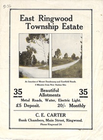
Flyer, Subdivisional Land Sale Brochure, East Ringwood Township Estate, Vic. - 1923
Bi-folded double sided land subdivision sale advertisement with location map and summary of local facilities and services. Includes two additional images of allotment plan with subsequent handwritten notations.Subdivision includes Mount Dandenong Road, Grey Street, and Eastfield Road. Agent - C.E. Carter, Bank Chambers, Main Street, Ringwood. Phone Ringwood 24. -
NMIT (Northern Melbourne Institute of TAFE)
Report: Campuses, buildings and rooms - Layouts and listings July 1994 NMCOT
Spiral bound report of 284 pages, A4 size. Consists mainly of campus location maps and room layout plans by building. Prepared by Neville Lester for Northern Metropolitan College of TAFE.northern metropolitan college of tafe, buildings, reports, nmit -
 Whitehorse Historical Society Inc.
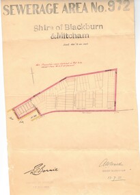
Document, Sewerage area, 13/07/1933 12:00:00 AM
Plan of sewerage area no. 972, Shire of Blackburn and Mitcham, scale 400' to an inch. 13 July 1933. Note that the area including Stuart Street on the map is now the Thiele Court area.sewerage and sanitation, shire of blackburn and mitcham, whitehorse road, blackburn, railway road, vine street, lithgow avenue, downing street, frankston street, stuart street, thiele court -
 Brimbank City Council
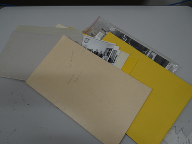
Manilla Folder
Manilla folder with a number of various sizes envelopes containing black and white phots form around mid 20th century of councillors, residents, street. Aslo number of urban plans and maps. -
University of Melbourne, Burnley Campus Archives
Map, City of Kew, Hyde Park, c. 1970
(1) Photocopy of hand drawn plan of park showing contours. No 7/3. Scale 1 inch:40 ft. (2) Map 45 from Melway with Hyde Park highlighted.kew, hyde park -
Port Melbourne Historical & Preservation Society
Map - MMBW, c. 1894
Melbourne and Metropolitan Board of Works 1894, Plan number 18 Segments Shown: Between 322 - 486 Smaller scale map incorporating piers, lagoon and town north to beyond boundaryIn pencil: "7/7/94" (Which is the copyright date)engineering - board of works, piers and wharves - railway pier, piers and wharves - town pier, sandridge lagoon, transport - tramways, transport - railways, gasworks, built environment -
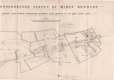 Bendigo Historical Society Inc.
Map - STRUGNELL COLLECTION: NEW CHUM LINE, 25/5/01
Map, Surface Plan Showing underground workings along portion of the New Chum Line.South Belle Vue United, Eureka Extended, New Chum Railway, Shenandoah Co. Shamrock Co..A.S.Whitelawmap, bendigo, new chum line -
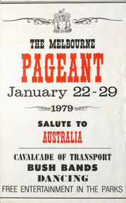 Melbourne Tram Museum
Poster, Victorian Government, "The Melbourne Pageant - January 22 - 29 1979 - Salute to Australia, Cavalcade of Transport", 1979
Poster - special size sheet, titled "The Melbourne Pageant - January 22 - 29 1979 - Salute to Australia, Cavalcade of Transport" advertising the planned events and dates with a map. Two copies held.trams, tramways, australia day, mmtb, melbourne, tramcars, pageant, melbourne pageant -
 Bacchus Marsh & District Historical Society
Map, Plan of the property of Messers Atkins and Clarke to be sold at the Mansion, Bacchus Marsh 19th April 1856. Copy 1
This plan of land allotments for sale indicates the property once owned by the Bacchus family in and around the township area of Bacchus Marsh. The Bacchus family sold their property in Bacchus Marsh to John Atkins and Robert Nalder Clarke in March 1851. Atkins and Clarke kept the property for a number of years until April 1856 when these allotments were put up for sale.This plan is almost identical to another copy held by the Bacchus Marsh and District Historical Society, VC Record 452, BMDHS collection). This plan, VC Record 707 Copy 1, contains a little more detail overall than VC Record 452 Copy 2, such as who did the survey work for the plan (R.C. Bagot) and who the selling agents were, (W.M. Tennent), and on the right side of the plan near the Lerderderg River is indicated the general area for a second parcel of land from this sale which is to be sold. There is also a compass illustration indicating north and south compass points.This is a very early land sales plan for the township of Bacchus Marsh and it therefore provides some clues as to how the early urban development of the township took place. Upon seeing the map in 1911 Bacchus Marsh Express newspaper editor Christopher Crisp wrote "The sale appears to have created the present township, which had a nucleus in earlier times further east", Express, 30 September, 1911, page 3.A single page paper plan showing allotments of land for sale. The subdivided land shown was owned by John Atkins and Robert Nalder Clarke, but previously owned by the Bacchus Family and was in and around their Manor House (Mansion) property in Bacchus Marsh.There are 5 portions of land further divided into numerous small portions. The land for sale is bounded by the present day streets of Main Street, Young Street, McFarland Street, Morton Streets, Crook Street, and part of the eastern section extends to the Lerderderg River. Scale: 8 chains to 1 inch The plan is pasted into a bound volume containing 76 maps or plans in total. BMDHS Loc: AR/B12/S4 Bacchus Marsh Township and Nearby Districts Maps Volume In-house Digital copies: BMDHS, Computer Network: Maps\Bacchus Marsh Township and Nearby Districts Maps VolumeHeading: Plan of the first portion of land. The property of Messers Atkins and Clarke situate at Bacchus Marsh. To be sold by W.M. Tennent & Co. at the Mansion on the Ground on Saturday the 19th April 1856. Below heading: Jas Ferguson, Lithographer On upper right side: Subdivided by R.C. Bagot London and Liverpool Chambers, Melbourne. 'Thos Taubman'. Post Office Stamp: BACCHUS MARSH VICTORIA MY 6, 63bacchus marsh victoria maps, bacchus family, land sales, manor house bacchus marsh -
Port Melbourne Historical & Preservation Society
Plan - Water cart used in road construction, Borough of Sandridge, 21 Nov 1870
From a group of maps and plans not required by the Port Melbourne Council Engineering Department in May 1994 and offered at that time to the Port Melbourne Historical Society.Plan of water cart used in road construction including 4 diagrams and scales: signed by Borough Surveyor, Nov 21 1870.built environment - civic, engineering, engineering department - borough of sandridge -
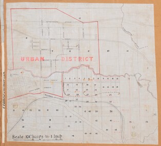 Bacchus Marsh & District Historical Society
Map, Bacchus Marsh Urban District
The date of this map has not been established but the date would be sometime after 1887 as the Bacchus Marsh Railway Station, which opened in 1887, is shown on the map. A single page paper map showing blocks of land in the urban district of Bacchus Marsh. The 'urban district' is indicated by red drawn lines on the map and includes streets and blocks on the northern side of the Werribee River in Bacchus Marsh, and streets and blocks south of the Werribee in Maddingley. Scale 10 chains to 1 inch. The map is pasted into a bound volume containing 76 maps or plans in total. High resolution digital image stored on BMDHS computer network. bacchus marsh victoria maps, maddingley victoria maps -
Bendigo Historical Society Inc.
Map - CAMPBELL COLLECTION: BENDIGO AND DISTRICT MAPS, 22-3-29
Map. Marong, Parishes of Marong, Lockwood and Mandurang, Scale 20 chains to 1 inch, Total area 5106 acres. Crusoe Reservoir & Viaduct and water race. Compiled in W.P.B. fro Field Survey and Parish Plans. B.W.L.22-3-29 (number 389 in map cupboard 1)B.W.L.map, bendigo, allotments -
 Falls Creek Historical Society
Plan - Leases of part of Falls Creek Tourist Area
Bob (Herman) Hymans (a former member of the Royal Netherlands Navy was born in Bloemendaal, Holland on 30th September 1922. During World War II he fought against the Japanese in the Dutch East Indies (now Indonesia) and was imprisoned in Changi and on the Burma Railway. After gaining qualifications as a Ski Instructor, Bob arrived in Falls Creek in May 1950. Working as an Instructor and Supervisor at Bogong Lodge, Bob decided his future was in accommodation. He was successful in negotiating an indenture for land from the State Electricity Commission (SEC). It took Bob two years to build his Grande Coeur Chalet but, tragically, it was burned down in August 1961. Bob also built the first Chairlift in Australia. This was a single chairlift and the structure was built from wooden electricity poles. He was constantly full of new ideas and proposals for the village. Bob Hymans died on 7th May 2007. This Collection of documents and letters tells the story of Bob’s endeavours to develop Falls Creek into the ski village it is today. This map is significant because it documents boundaries of early leases in Falls Creek Tourist Area.This map is part of Bob Hymans documents. It is a large Surveyor's Plan of a section of the Falls Creek Tourist Area. It is endorsed by J Parker, Chief Surveyor of the State Electricity Commission of Victoria on 27-3-84. It shows streets, lot numbers and measurements. It was a compilation created from existing lease maps. Heading - PART OF FALLS CREEK TOURIST AREA PART OF CROWN ALLOTMENT 1 PARISH OF CARRUNO PART OF CROWN ALLOTMENT 1 PARISH OF DARBALANG COUNTY OF BOGONGmap of falls creek, falls creek leases, falls creek 1980s