Showing 3847 items
matching surveyed
-
 Bendigo Historical Society Inc.
Map - JACK FLYNN COLLECTION: BAMAWM, 19/08/1924
Map: Parish of Bamawm, County of Bendigo. Parish plan.Photo Lithographed at the Department of Lands and Survey, Melbourne by W.J. Butson. 19.8.24map, bendigo, parish plan, bamawm -
 Bendigo Historical Society Inc.
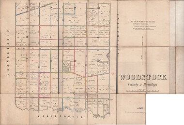
Map - JACK FLYNN COLLECTION: WOODSTOCK, 27/03/75
Map: Parish of Woodstock , County of Bendigo. Parish plan.Photo-Lithographed at the Department of Lands and Survey Melbourne by J. Noone. 27.3.79map, bendigo, parish plan, woodstock -
 Stawell Historical Society Inc
Map, Lexington County of Borong 1910, 1910
Parish to the North East of MoystonA2 Parish mapPhoto Lithographed at the Department of Lands and Survey. Melbourne by T.F. McGauran 5.12.10survey -
Stawell Historical Society Inc
Map, T.F. McGauran, William Couty of Borong 1891, 1891
Stawell Water Supply Reserve. Grampians State Forest. Dairy Creek, Fyans Creek, Barney's Creek, Bovine Creek, Glasstree Creek, Stoney Creek. Stawell Water Supply Aquaduct Fkuming Tunnel.A2 Parish Map of Willam Inculdin Stawell Water Supply Reserve and Creeks. Marked in redPhoto Lithographed at the Department of Lands and Survey Melbourne. By T.F. McGauran 20.07.91 water supply survey -
Stawell Historical Society Inc
Map, T.F. McGauran, Winjallock County of Kara Kara, 1900
Noth of Navarre and BarkleyA2 Map0f Parish of Kara Kara.Photo Lithographed and the department of Lands & Survey, Melbourne by T.F. McCauran 22.10.00survey -
Stawell Historical Society Inc
Map, Department of Lands and Survey, Borough of Stawell. Parishes of Stawell and Illawarra 1903, 1903
Victoria Co., St Georges Co., Wimerra Co., Leviathon Co. Tramway, Quarry reserve, Newington Co., Galatea Co., Moonlight Co., Federal Co., Borough reservior., A0 Map of Stawell on linen backing. Plus one Printed on PaperPhoto Lithograped at the Department of Lands and survey Melbourne by T.F. McGauran 13.6.03surevy -
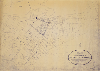 Queenscliffe Maritime Museum
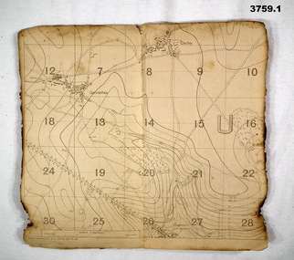
Map - Survey Chart, J. P. Larkin, Re-Survey of Queenscliff Channel, 29 October 1928
A paper chart showing sounding around the Queenscliff Channel dated 1928Victoria Port Phillip October 1928, Re survey of Queenscliff Channelqueenscliff channel, surveying, navigation -
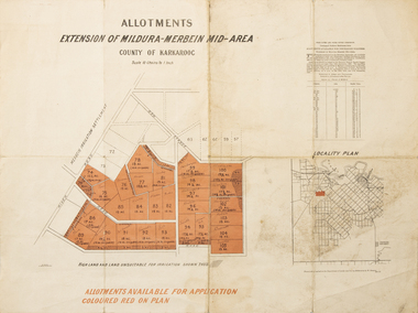 Merbein District Historical Society
Map - Allotments Extension of Mildura-Merbein Mid-Area, Allotments available, 23 November 1920
Allotments available to Discharged Soldiers Discharged Soldier's Settlement Act Historic Large map, folded in 4, coloured map of Merbein indicating allotments available and locality plan. Scale 10 chain to 1 inchPhoto-Lithographed at Department of lands Survey, Melbourne J. Butson 23.11.20discharged soldiers, ww1, soldier settlement, irrigation -
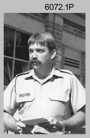 Bendigo Military Museum
Photograph - Printer Technicians and other RASvy personnel at the Army Survey Regiment, c1980s
These ten photographs were probably taken circa 1980s in Lithographic Squadron at the Army Survey Regiment, Fortuna, Bendigo. Most of the photos were taken on the shop floor in the Print Room.This is a set of photographs of Printer Technicians and other RASvy personnel in Lithographic Squadron, Army Survey Regiment, Bendigo c1980s. The photographs were printed on photographic paper and are part of the Army Survey Regiment’s Collection. The photographs were scanned at 300 dpi. .1) - Photo, black & white, c1980s, WO2 Steve Egan, Lithographic Squadron .2) - Photo, black & white, c1980s, WO2 Jeff Lynch, Lithographic Squadron .3) - Photo, colour, c1980s, SPR Peter Dillon, Lithographic Squadron .4) - Photo, black & white, c1980s, L to R: Peter Dillon, unidentified, Lithographic Squadron .5) - Photo, black & white, c1980s, L to R: SPR Colin Yeats, SPR Graeme Spong, CPL Peter Dillon, Lithographic Squadron .6) - Photo, black & white, c1980s, L to R: SPR Colin Yeats, WO2 Ralph Chant, Lithographic Squadron .7) - Photo, black & white, c1980s, L to R: Dale Hudson, Mark ‘Dogs’ Doherty, Lithographic Squadron .8) - Photo, black & white, c1980s, L to R: SGT Greg Rowe, WO1 Trevor Osborne, Dale Hudson, Lithographic Squadron .9) - Photo, black & white, c1980s, L to R: unidentified, SGT Kim Reynolds, Shane ‘Soupy’ Campbell, Lithographic Squadron .10) - Photo, colour, 1987, L to R: Jim Ash, Daryl South, Jeff Willey, unidentified, Lithographic Squadron.1P to .4P – not annotated .5P - annotated on front with ‘I AM BROKE, I’M NOT and me neither’, annotated on back with ‘Curly Larry Moe’ .6P to .9P – not annotated .10P – annotated with dateroyal australian survey corps, rasvy, army survey regiment, army svy regt, fortuna, asr, litho, printing -
 Bendigo Military Museum
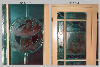
Photograph - Army Survey Regiment - Fortuna Interior, Bendigo, c1985
This set of 22 photographs was taken inside Army Survey Regiment’s Fortuna Villa circa 1985. The photos feature some of Fortuna Villa’s interior. Unfortunately, the magnificent array of colours and hand-painted features of Fortuna’s leadlight windows are not highlighted with light transmission, as the photographer did not take the photos in the daytime. See item 6456.30P, for photos of Fortuna Villa’s exterior and The Army Survey Regiment’s out-buildings that were taken at the same time.This set of 22 photographs was taken inside Army Survey Regiment’s Fortuna Villa circa 1985. The colour photographs were printed on photographic paper and are part of the Army Survey Regiment’s Collection. The photographs were scanned at 300 dpi. .1) & .2) - Photo, colour, c1985. Fortuna Villa – Reception/Music Room leadlight windows. .3) - Photo, colour, c1985. Fortuna Villa – Entrance foyer door and leadlight windows. .4) - Photo, colour, c1985. Fortuna Villa – Entrance foyer vaulted ceiling. .5) - Photo, colour, c1985. Fortuna Villa – Dressing Room bay leadlight windows. .6) - Photo, colour, c1985. Fortuna Villa – Dressing Room wood panel wardrobe (concealed marble bath inside). .7) - Photo, colour, c1985. Fortuna Villa – Main bathroom’s solid cedar toilet chest and water pitcher set. .8) to .14) - Photo, colour, c1985. Fortuna Villa – Drawing Room bay leadlight windows. .15) to .16) - Photo, colour, c1985. Fortuna Villa – Cupola stairway leadlight windows. .17) - Photo, colour, c1985. Fortuna Villa – Dining/ballroom doorway with velvet wallpaper. .18) - Photo, colour, c1985. Fortuna Villa – Dining/ballroom. .19) - Photo, colour, c1985. Fortuna Villa – Billiard room’s timber vaulted ceiling. .20) & .21) - Photo, colour, c1985. Fortuna Villa – Top floor nursery samples of original wallpaper. .22) - Photo, colour, c1985. Fortuna Villa – Top floor ballroom/gymnasium’s elaborate vaulted ceiling.There are brief descriptions on a note behind each photograph.royal australian survey corps, rasvy, army survey regiment, army svy regt, fortuna, asr -
 Bendigo Military Museum
Map - TRENCH MAPS WW1, 1918
Areas covered on both, “Villers Brettoneaux, Cachy, Hangard, Gentelles”. Items re William Alexander No 502 AIF. Refer Cat No 3746.3 for his service details.(.1 & .2) Both maps are same area, field survey 24.4.1918, scale 1:20,000.map, trench, france -
Federation University Historical Collection
Tool - Scientific Instrument, Theodolite: Serial No. 25353; Also known as "Transit" in the USA, c1939
A surveying instrument mounted on a wood base with Slotted ends Instrument to be mounted on a tripod - Item No 7459On magnetic compass dial: "C.L.BERGER & SONS" "BOSTON USA" 25353theodolite, transit, united states of america, berger & sons, magnetic compass, compass dial, surveying instrument -
 Ringwood and District Historical Society
Archive, Lands Department Field Notes, Ringwood 1878-1955 (Parent Record)
This record is the Parent Record for contents of folder "Lands Department - Survey of Field Notes of Ringwood Area". -
 Bendigo Historical Society Inc.
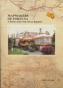
Book - FORTUNA COLLECTION: MAPMAKERS OF FORTUNA
MAP MAKERS OF FORTUNA - A HISTORY OF THE ARMY SURVEY REGIMENT - 234 pages with maps, illustrations, photos.Valerie Lovejoyhistory, army survey regiment, bendigo, army survey regiment, fortuna, cartography, mapmakers -
 Bendigo Historical Society Inc.
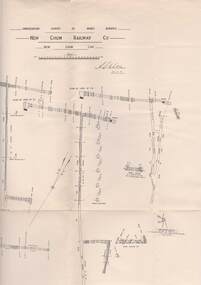
Map - STRUGNELL COLLECTION: UNDERGROUND SURVEY OF MINES, BENDIGO, 25-5-01
Map, Underground Survey of Mines, Bendigo, New Chum Railway Co, New Chum Line.A.S.Whitelawmap, bendigo, new chum railway co. -
 Bendigo Historical Society Inc.
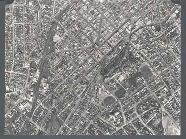
Photograph - WES HARRY COLLECTION: AERIAL VIEW OF BENDIGO CBD, 1966
Aerial photograph of the Bendigo CBD. On the reverse is written : 'City of Bendigo 1966, State aerial Surveyplace, aerial view of bendigo, cbd, bendigo cbd, aerial survey of victoria -
Bendigo Historical Society Inc.
Map - BOROUGH OF EAGLEHAWK RE-SURVEY, 6/06/1883
Map: Re-survey, Borough of Eaglhawk, Parishes of Nerring and Sandhurst, Sheet No. 1. Parish planmap, bendigo, re-survey, borough of eaglehawk, re-survey -
Tatura Irrigation & Wartime Camps Museum
Photograph, Clark D, 1989
49 Hogan street Tatura, office of W. S. Murray, engineer, surveyor. Water Trust office, Dr's residence, J. Reilly's residence. Present Museum.Black and white photograph of 6 men and surveying equipment outside 49 Hogan street Tatura.on building - Walter Scott Murraywalter scott murray, water trust, museum -
Lakes Entrance Regional Historical Society (operating as Lakes Entrance History Centre & Museum)
Book, Hancock, Keith, Australian Society, 1989
A survey of the social history of Australia, prepared to celebrate the Australian Bicentennial 1988. Includes Bibliography and Index.economic history -
Whitehorse Historical Society Inc.
Map, Boronia Road, Vermont, 1970
Enlargement of aerial photograph of Boronia Road, Vermont. State Aerial Survey 1970 Run 37Enlargement of aerial photograph of Boronia Road, Vermont. State Aerial Survey 1970 Run 37Enlargement of aerial photograph of Boronia Road, Vermont. State Aerial Survey 1970 Run 37boronia road, vermont, lusk drive, vermont, morack road, vermont south, allison court, vermont, trinian street, vermont, cosgrove street, vermont, mawson court, vermont, aerial photographs -
Whitehorse Historical Society Inc.
Map, Boronia Road, Vermont, 1970
Enlargement of Aerial photograph of Boronia Road Vermont, State Aerial Survey, 1970. Run 37Enlargement of Aerial photograph of Boronia Road Vermont, State Aerial Survey, 1970. Run 37Enlargement of Aerial photograph of Boronia Road Vermont, State Aerial Survey, 1970. Run 37boronia road, vermont, gallus close, vermont, moore road, vermont, carlinga drive, vermont, beleura avenue, vermont, olinda crescent, vermont, penllyne avenue, vermont, holyrood drive, vermont, aerial photographs -
Whitehorse Historical Society Inc.
Document, History of the South Vermont area
A short history of South vermont, from the land survey in 1855, including pioneers' names and occupations.A short history of South vermont, from the land survey in 1855, including pioneers' names and occupations.A short history of South vermont, from the land survey in 1855, including pioneers' names and occupations.vermont south, smith, l. l. dr., lobb, a, hoadley, mrs, confectionery, orchardists, norwich village, vermont, land subdivision -
 Queenscliffe Maritime Museum
Newspaper - News articles from various newspapers re Queenscliffe, Queenscliff news articles - various from 1981, 3, 6 & 7, c1960 onwards
Port Phillip shipwrecks.Various newspaper articles re Port Phillip navigational, wreckage & ship's draft issues & surveys.Reverse " NIL "port phillip shipping issues. -
University of Melbourne, Burnley Campus Archives
Plan, Horticultural Project Conservation and Management Plan Wombat Park, c. 1990
Photocopies of plan drawn by M. Gilbert of Survey Area C-G, with numbered plant list.m. gilbert, wombat park, management plan -
 Bendigo Historical Society Inc.
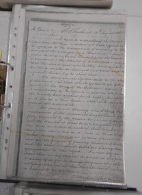
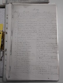
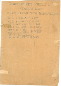
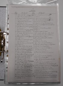
Document - RICHARD LARRITT COLLECTION: LETTERS, 1850s
Folder of Richard W. Larritt's letters/notes regarding the surveying of land in the Bendigo (Sandhurst) region.Richard Larrittperson, government, richard w. larritt -
 Bendigo Historical Society Inc.
Document - RICHARD LARRITT COLLECTION: LETTERS, 1850s
Folder of Richard W. Larritt's letters/notes regarding the surveying of land in the Bendigo (Sandhurst) region.Richard Larrittperson, government, richard w. larritt -
 Bendigo Historical Society Inc.
Document - RICHARD LARRITT COLLECTION: LETTERS, 1850s
Folder of Richard W. Larritt's letters/notes regarding the surveying of land in the Bendigo (Sandhurst) region. Richard Larrittperson, government, richard w. larritt -
 Bendigo Historical Society Inc.
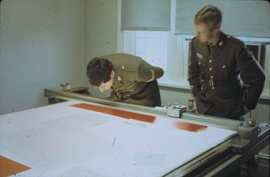
Slide - AHQ,SURVEY REGT, FORTUNA,BENDIGO, April 1970
Slide. AHQ, Survey Regt, Fortuna,Bendigo. Two Army persons inspecting a document on a table.slide, bendigo, ahq, survey regt, fortuna, bendigo., ahq, survey regt, fortuna, bendigo. -
 Bendigo Historical Society Inc.
Document - RICHARD LARRITT COLLECTION: LETTERS, 1850s
Folder of Richard W. Larritt's letters/notes regarding the surveying of land in the Bendigo (Sandhurst) region.Richard Larrittperson, government, richard w. larritt -
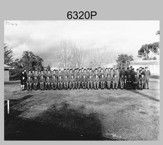 Bendigo Military Museum
Photograph - Army Survey Regiment Warrant Officers and Sergeants, Fortuna, Bendigo, c1973
This photograph of the Army Survey Regiment’s Warrant Officers and Sergeants was taken on the parade ground at Fortuna Villa, Bendigo in c1973. WO1 John Hogan served as RSM of the Regiment from 1968 to 1976.This is a photograph of Warrant Officers and Sergeants posted to the Army Survey Regiment Fortuna Villa, Bendigo Victoria, c1973. The photograph was printed on photographic paper and is part of the Army Survey Regiment’s Collection. The photograph was scanned at 600 dpi. .1) - Photo, black & white c1973. Back Row L to R: Irene Saunders, Bob Hayden, Lloyd Patterson, Chris Sharp, Sgts Mess Spvr, Lloyd Harvey, John Waight, Ivor Hastings, Ace Evans, Andy Covington, Gordon Haswell, Jim Jefferies, Mick Dempster, Bill Forrest, Max Neil, Ted Burgess, Chris Kelly, Graeme Beasley, Peter Mansell, Dave Miles, unidentified, Geoff Wasser, Errol Fletcher, Doug Malligan, Len Thirwell, Michael Wagland, Ian Bootland, Peter Dew, Jeff Lynch, John Rankine, George Austen, Jim Mitchell, Ken Slater, Alan Carew, Chris Wardley, Jim Mulqueen, Evan Giri. Front Row L to R: Marjorie Knight, Tom Pattison, Don Taylor, Bob McKenna, Bob Coultard, Stan Vote, Brian Rogers, Aub Harvey, RSM John Hogan, Neil Rankin, Clive Andrews, Tony Ellis, Alex Munro, Roger Rix, Joe Farrington, Tibby Szentirmay BEM, Fred Panknin, Ken Rich, Jack Williams, Ian Batt UK Exchange.There are no personnel annotated. ‘7744’ annotated on top left corner of photo.royal australian survey corps, rasvy, army survey regiment, army svy regt, fortuna, asr