Showing 2472 items matching " township"
-
 Clunes Museum
Photograph, 2006
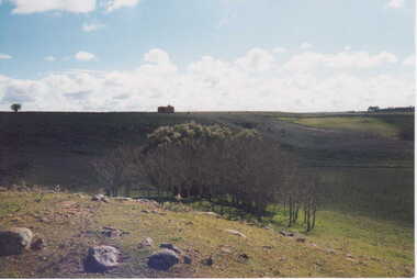
16 COLOURED PHOTOGRAPHS OF POWDER MAGAZINE, SITUATED IN A PADDOCK ON SMEATON ROAD APPROX, 2KM FROM TOWNSHIP ON LEFT HAND SIDE. IN DISTANCE TREES IN THE FOREGROUND SOME BOULDERS SHOWN.local history, photography, photographs, mining -
 Lakes Entrance Historical Society
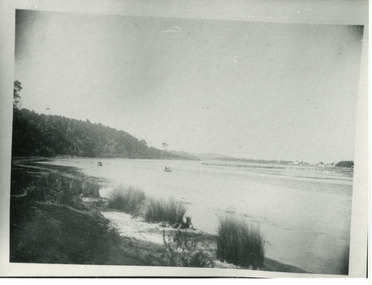
Photograph - North Arm, Phillips, Miss L, 1910c
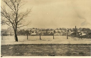
Black and white photograph of North Arm. It shows the reedy shoreline in foreground, jetty to island in lake, two small boats on water, distant view of township. Lakes Entrance Victoriawaterways, topography, vegetation -
 Lakes Entrance Historical Society
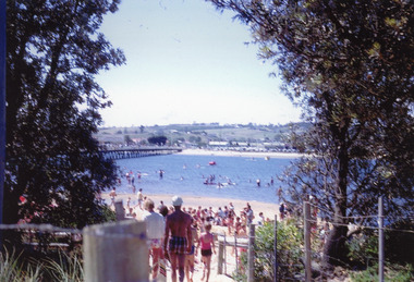
Photograph, Nelson Joan, 1980c
Colour photograph of a crowd on the beach at the southern shore of Cunninghame Arm. It shows many people enjoying the sand and water, footbridge and northern shore of township in distance. Lakes Entrance Victoriawaterfront, recreation -
 Clunes Museum
Map - CLUNES 1987, CHARLES FENTON, 1987
.1 .2 A MAP OF CLUNES TOWNSHIP - ORIGINAL AND COPY - 1987. ALL STREETS AND BIRCH'S CREEK MARKED WITH ALLOTMENT NUMBERS. .3 SAME MAP SHOWING PATH OF BUSHFIRE IN 1944CLUNES 1987local history, document, maps, clunes township -
 Lakes Entrance Historical Society
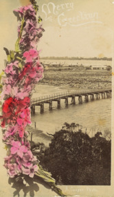
Postcard - North Arm bridge Lakes Entrance Victoria, A Cooper photograph, 1910 c
Easter Greetings written on back of card to Dear Will from your loving girl Doris Also a black and white photograph of North Arm Bridge c 1900 VTMH05369.1Sepia toned postcasrd of view of North Arm bridge and looking across township Cunninghame Arm to hummocks hand coloured flowers down the left side Lakes Entrance Victoriabridges, correspondence -
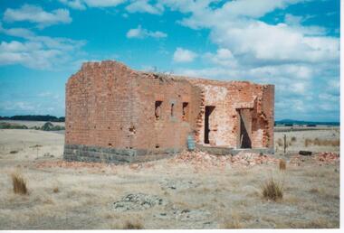
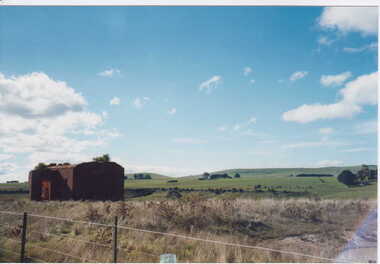 Clunes Museum
Photograph, KODAK, C1800'S
VIEW OF POWDER MAGAZINE USED IN MINING DAYS TO STORE EXPLOSIVES. BUILDING MATERIALS - SOLID BRICKPOWDER MAGAZINE USE TO STORE EXPLOSIVES DURING THE DEEP LEAD GOLD MININGCOLOURED PHOTOGRAPH OF POWDER MAGAZINE EXTERIOR. SITUATED IN A PADDOCK ON SMEATON ROAD APPROX. 2 KM. FROM TOWNSHIP ON LEFT HAND SIDE. IRON POST AND WIRE FENCE IN FOREGROUND.powder magazine, photograph, local history -
 Clunes Museum
Photograph, KODAK, 1999
VIEW OF POWDER MAGAZINE USED IN MINING DAYS AT CLUNES TO STORE EXPLOSIVES. BUILDING MATERIALS SOLID BRICKCOLOURED PRINT OF POWDER MAGAZINE, SITUATED IN A PADDOCK ON SMEATON ROAD APPROX. 2 KM FROM TOWNSHIP ON THE LEFT HAND SIDE. IN DISTANCE TREES IN THE FOREGROUND SOME BOULDERS SHOWN.local history, photography, photographs, mining -
 Lakes Entrance Historical Society
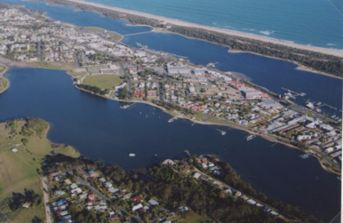
Photograph - North Arm Lakes Entrance, 2005
Colour aerial photograph showing North Arm, township, eastern end of Cunninghame Arm across to the ocean beach, Ninety Mile beach, Bass Strait Lakes Entrance Victoriaaerial photograph, aircraft, lakes entrance -
 Robin Boyd Foundation
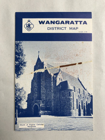
Map, RACV General Insurance, RACV Wangaratta District Map
District Map of Wangaratta and surrounding townshipswangaratta, victoria, map, beechworth, albury-wodonga, walsh st library -
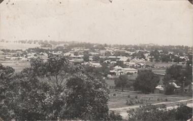 Rutherglen Historical Society
Photograph - Image, 1914-1920 (Approximate)
View across section of Rutherglen TownshipBlack & white photograph, unframed but pasted to pages of an album. Rutherglen"Rutherglen" -
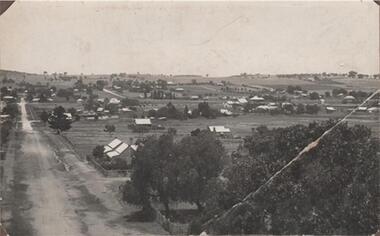 Rutherglen Historical Society
Photograph - Image, 1914-1920 (Approximate)
View looking across township of RutherglenBlack & white photograph, unframed but pasted to pages of an album. Rutherglen"Rutherglen" -
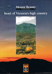 Kiewa Valley Historical Society
Poster Brochure, Mt Beauty Tawonga Heart Of Victoria's High Country, Circa 1995
The Item is a pictorial time piece of the valley and usage, farms,industry,town area, vegetation and winter snow levels Historical and the social-economical development at circa 1995 of land usage and residential buildings style.Major social events e.g. Festival of the Bogong Moth and the Mt Beauty Mardi Gras. It is also a good historical record of tourism campaigns of the Alpine Shire and Mt Beauty Chamber of Commerce. Also see "KVHS 0125"Brochure folds out from a 20.5cm x 29.5cm to 82cm x 29.5cm poster type documentinside panoramic photo of snow tipped alpine mountain range incorporating the Mount Beauty township, farming area of the Kiewa Valley and relevant tourist orientated informationtourism mt beauty tawonga photographs, victorian alps -
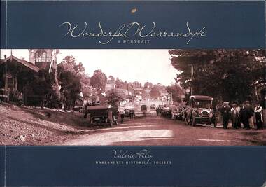 Ringwood and District Historical Society
Book, Valerie Polley, Wonderful Warrandyte - A Portrait, 2014
Soft-covered book by Valerie Polley, Warrandyte Historical Society, featuring photographs, sketches and text outlining early and contemporary development of Warrandyte township and community, first published in April 2014.Front cover - Peace Day celebrations in Warrandyte, July 1919. Acknowledgements: The book project Wonderful Warrandyte-A Portrait was made possible by a grant under the Australian Government's 2012-2013 Your Community Heritage Program (Your Community Heritage - Sharing Community Heritage Stories). Several members of the Warrandyte Historical Society were involved in this book project which evolved after several years of development ideas. Valerie Polley wrote the text and selected photographs. Special thanks go to the Steering Committee of Margaret Kelly, Andy Bevan-Jones, Richard Morton and Wayne Rankin for their knowledgeable input and beneficial editing advice, Murray Houghton for his specialised historical knowledge and advice on further references, and Diane Baird for editing. The book would not have been possible without all the dedicated work of the Society's members, past and present, who have contributed to the Society's substantial archive. All proceeds from the sale of this book go to the Warrandyde Historical Society. Photographs: Stephen Reynolds, Austin Polley, Valerie Polley, Wayne Rankin, Ron Harris, Merv Naughton. Flora and Fauna photography by Nth Warrandyte, Osborne Peninsula, Landcare, Inc. Maps: Jock Macneish -
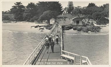 Phillip Island and District Historical Society Inc.
Photograph - Post Card, Early 20th Century
One of a group of photographs from the Bryant West Collection donated by Mary Karney.Black & White postcard. View from the pier of the Jetty Shed and Isle of Wight Hotel in the background. People walking down the pier towards the township. Two horse and carts beyond the shed.Cowes from the Pier. 9.cowes pier phillip island, cowes jetty shed, isle of wight hotel - cowes phillip island, bryant west collection, mary karney -
4th/19th Prince of Wales's Light Horse Regiment Unit History Room
Newspaper cutting, Feb 1900
Relates to Boer WarPart of a page from the Leader Newspaper printed in Feb 1900 about casualties suffered at Rensberg. Th page is badly damaged but shows shows photographs of some of the casualties and their home townshipsboer war casualties -
Bendigo Historical Society Inc.
Map - TOWNSHIP OF SANDHURST MAP
Map township of Sandhurst Portion B Bendigo Creek. Victoria zincographed at the Crown land's office, nos 54/21-57/12 Melbourne, April 21st 1857 (by G. Collis). -
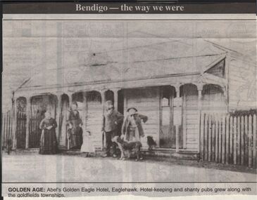 Bendigo Historical Society Inc.
Newspaper - JENNY FOLEY COLLECTION: GOLDEN AGE
Bendigo Advertiser "The way we were" from 1999. n Golden age: Abel's Golden Eagle Hotel, Eaglehawk. Hotel keeping and shanty pubs greww along with the goldfields townships.newspaper, bendigo advertiser, the way we were -
Clunes Museum
Plan - PLANS CLUNES CARAVAN PARK, NO. 1 - SHIRE OF TALBOT & CLUNES. IAN MANSLEY, SHIRE ENGINEER NO. 2 - LEO MCMAHON & ASSOCIATES PTY. LTD. LICENSED SURVEYORS & ENGINEERS, 31 LYONS ST. NTH. BALLARAT, 1976
NO. 1 PLAN - CLUNES CARAVAN PARK ENGINEER - IAN MANLEY NO. 2 PLAN - SECTION 15 TOWNSHIP OF CLUNES, COUNTY OF TALBOT, BY LEO MCMAHON AND ASSOCIATES, LICENSED SURVEYORS AND CIVIL ENGINEERSplans, caravan park, ian manley, plan section 15 -
 Whitehorse Historical Society Inc.
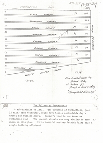
Document, Plan of Subdivision, 1861
Copy of plan of subdivision by Patrick RileyCopy of plan of subdivision by Patrick Riley of Section 77, Parish of Nunawading 'Springfield Township' 1861. Bounded by Whitehorse Road, Walker's Road, (now known as Springvale Road) and Springfield RoadCopy of plan of subdivision by Patrick Rileyland sales, riley, patrick, whitehorse road, nunawading, walkers road, springfield road, black street, robertson street, sandy street, burnt street, luckie street, bridge street, creek street, koonung street, thompson street -
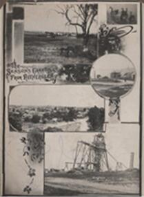 Rutherglen Historical Society
Photograph - Image, 1914 (Exact)
Black & white photograph, unframed but pasted to cardboard album page. A greetings postcard showing small scenes of the township, Mt Ophir vineyards, Garabaldi Mine, Swans and Great Southern Mine"The Season's Greetings From Rutherglen"mt ophir, garibaldi mine, great southern, winemaking, mining, gold mining, mount ophir -
 Greensborough Historical Society
Photograph - Digital Image, View of Greensborough from Partington's Flat, 1930c
View of Greensborough township from Partington's Flat.Digital copy of black and white photograph.partingtons flat, greensborough -
Tatura Irrigation & Wartime Camps Museum
Folder, Recollections of Eildon
Recollections of construction of Eildon Dam and life in the townshipBlue plastic folder. Black spine. White label. Handwritten titleeildon dam, water, irrigation, books, history, local, rural, industry -
 Stawell Historical Society Inc
Photograph, Upper Main Street Stawell 1880
Stawell Township - Upper Main Street 1880stawell -
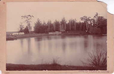 Clunes Museum
Photograph
NEWLYN RESERVOIR - WATER SUPPLY TO CLUNES TOWNSHIPSEPIA PHOTOGRAPH OF NEWLYN RESERVOIR SHOWING SMALL BRIDGE - TWO BUILDINGS AND PINE AND POPLAR TREES SURROUNDS.SHIRE OF TALBOT AND CLUNESlocal history, photography, photographs, water supply -
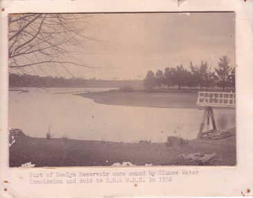 Clunes Museum
Photograph
NEWLYN RESERVOIR - SUPPLIES WATER TO CLUNES TOWNSHIPSEPIA PHOTOGRAPH OF PART OF NEWLYN RESERVOIR - TREES SURROUNDING WATER EDGE. SMALL DANDING STRUCTURE ON RIGHT SIDE. BARE TREE BRANCHES ON LEFT SIDE OF PHOTOGRAPH.PART OF NEWLYN RESERVOIR ONCE OWNED BY CLUNES WATER COMMISSION AND SOLD TO S.R. & W.S.C. IN 1958local history, photography, photographs, water supply -
 Malmsbury Historical Society
Postcard (Item), Postcard Snow In Malmsbury 1922 Kodak Postcard, Malmsbury 29/6/1922
Associated with - Kodak Postcard People - "Township, Houses" -
 Melbourne Water
Photograph, North Cocoroc State Primary School, 1950s
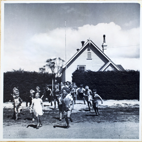
As the Yarra became unsuitable as a source of water, several attempts were made to find alternative sources for the growing population of Melbourne. It was not until 1891 that the efforts to sewer Melbourne came to fruition with the setting up of the Melbourne Metropolitan Board of Works (MMBW), now known as Melbourne Water. From 1891 until 1992, it was the responsibility of the MMBW to safeguard public health by providing a sewerage system and a safe water supply system. In 1992, The MMBW merged with a number of smaller urban water authorities to form Melbourne Water. The township of Cocoroc was created in 1894 at the Metropolitan Sewage Farm (now the Western Treatment Plant) to house the workers it employed. The name 'Cocoroc' means 'frog' in the language of the Wathaurung people — the Traditional Owners of the land the treatment plant was built on. By the early 1950s there were nearly 100 houses, a town hall, football ground (and team), swimming pool, tennis courts, four schools and a post office, and by the 1970s some 500 people were living in Cocoroc. As it became too expensive for the MMBW to subsidise, Cocoroc was abandoned. By 1973 most of the houses and other buildings were demolished or moved to Werribee. All that is left now of Cocoroc are two small, empty, concrete swimming pools, a few weatherboard sheds and a big iron water tank. This photograph detailing an exterior view of the North Cocoroc State Primary School, is historically significant as it captures children at play within a purpose built community. The School that was one of four was built to educate the children of the MMBW workers. As the school no longer exists, this photograph is the only tangible evidence left of the building, also showcasing the style of buildings in this era. cocoroc, township, school, mmbw, melbourne metropolitan board of works, melbourne water -
 Bendigo Military Museum
Photograph - POSTCARDS, PHOTOGRAPHIC, Unknown
Postcard photos of townships in France & Belgium 1914 - 1919.38 x sepia photo post cards. .1) Man & the Donkey Melbourne .2) Military funeral Australian .3) Porte de Neptune .4) - .5) Ypres .6) - .13) Aire-Sur-La-Lys .14) - .18) Steenwoorde .19) - .25) Poperinghe .26) - .38) Amiensmilitary funeral, ypres, aire-sur-la-lys, steenwoorde, poperinghe, amiens -
 Rutherglen Historical Society
Photograph - Image, 1949
Believed to be the Advance Australia Hotel, Great Northern township.Black and white photograph of a timber building, close to the edge of a road. Written on back of photo: "The Advance Aust. Hotel on Murray Valley H/way near Rutherglen. 1949"hotels, advance australia hotel, great northern -
Hume City Civic Collection
Photograph
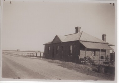
The woodland area was photographed on the outskirts of the old Sunbury township.The landscape featured in this image was typical of Sunbury's surrounds in the 19th and early years of the twentieth century. A copy of a non-digital black and white photograph of an woodland area. Two men with a horse and cart are visible in the image.VIEW OF SUNBURYhorses, drays, trees, c. nettleton