Showing 733 items matching "aerial photo"
-
 Creswick Campus Historical Collection - University of Melbourne
Still Image, 1952
Subject: King Lake . 6 brown envelopes marked Run 3, 4, 7, 7a, 8, 9 containing c. 80 prints. 1 section of a topographical map marked State Aerial Survey. Stored in a brown cardboard file box marked King Lake Run No.3 - 9. (x9). Photos commissioned by Forests Commission Victoria.Aerial Photographs -
 Sunshine and District Historical Society Incorporated
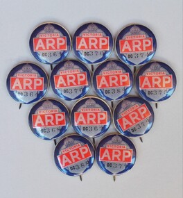
Air Raid Precautions (ARP) badges, Circa early 1940's
Mr Webb King was an Air Raid Warden during World War 2. These badges were found when his workshop was being cleared out, and so were donated to our society. The badges in our possession do not have the word WARDEN printed on them, like the image of the badge shown on the Darebin Heritage 'Air Raid Protection Services (ARP)' publication, or the image of a badge offered for sale on ebay. At this stage we are uncertain of why this is so. If anybody knows the answer then please leave a message on this site. During World War 2 Australian municipalities were expected to take precautions against air raids, with the Government campaigning to recruit men over 45 to be volunteer Air Raid Wardens. It was also common for women to become wardens. Wardens carried gas masks, helmets, and rattles or whistles. The wardens received 7 to 8 one hour sessions of training, and their chief duty was to advise people of precautions to take, and to ensure those precautions were taken. Air Raid Precautions included air raid drills, shelters (usually trenches), first aid, fire fighting, rescue of 'gassed' persons, evacuation drills, demolition and repair squads, monitoring of blackouts. Melbourne was deemed vulnerable to aerial attack because of its centralised port and industrial facilities and so Anti-aircraft guns were installed in Maribyrnong. By early 1942 more than 60,000 people voluntarily carried out Air Raid Precautions duties according to the Autobiography of Robert V. J. Padula OAM. As the threat diminished during 1943 and 1944 the need for air raid precautions was slowly reduced, and some shelters (trenches) were filled. The two photos showing Air Raid Wardens are out of copyright and have been sourced from the 'Argus Newspaper Collection of Photographs, State Library of Victoria.' The image showing one warden on Swanston Street Melbourne has been cropped to remove extras not connected with the photo. Other sources of information for this report are: (1) http://bpadula.tripod.com/autobiography/id100.html, (2) https://www.awm.gov.au/exhibitions/underattack/mobilise/precautions.asp, (3) http://heritage.darebinlibraries.vic.gov.au/article/57. The ARP badges are a historic reminder of the precautions that were taken in Victoria during the early years of World War 2. The precautions were an effort to minimise the harmful effects of a theoretical air raid. The war started to turn and so an air raid never came, however many people received valuable training in what precautions needed to be taken.Pressed metal round badges with pins. Main feature of badges is the large whitish lettering ARP on a red background. A black outlined crown and the word VICTORIA in red on whitish background is also on the badges. At the bottom of the badges in black are the letters DC plus the numbers of the badges.Serial Numbers of the badges are: DC 361, DC 362, DC 364, DC 368, DC 370, DC 374, DC 375, DC 376, DC 377, DC 379, DC 388, DC 389.arp. arp badge, air raid precautions, air raid precautions warden, warden, badges -
 Ballarat Base Hospital Trained Nurses League
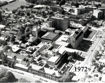
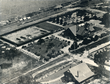
Aerial View of Ballarat Base Hospital, 1972
... Home nurses home 1972 aerial view Ballarat hospital Photo ...Aerial View of Ballarat Base Hospital, 1972Shows all hospital buildings including the Nurses HomePhoto - black & whitenurses, home, 1972, aerial view, ballarat, hospital -
 Ballarat Base Hospital Trained Nurses League
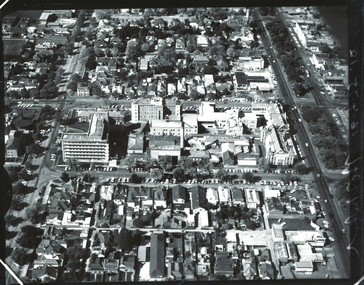
Aerial view BBH , neg Mr Harvey Photographer
... Street Nth Ballarat goldfields Aerial, view, BBH Photo Aerial ...Photoaerial, view, bbh -
 Peterborough History Group
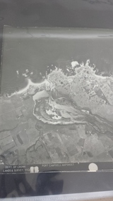
Photograph - Aerial Photograph Peterborough, Department of Crown Lands & Survey, Jan 1971
... 9" x 9" aerial photograph x 4 - (2 photos in duplicate ...Aerial photograph showing the past layout of the townSignificant in that it shows the town as it was in 1971.Square 9" x 9" aerial photograph x 4 - (2 photos in duplicate)Stamped Dept of Crown Lands & Surveypeterborough 3270, curdies estuary, bay of islands, crown land photograph, aerial photograph, department of crown lands -
 National Wool Museum
Photograph, Aerial view of mill circa 1920
... of mill circa 1920 H L S POTTER/ PHOTO STORES/... Aerial view ...Acquired when "Classweave Industries" closed down.Aerial view of mill circa 1920 H L S POTTER/ PHOTO STORES/...textile mills woollen mills, classweave industries pty ltd federal woollen mills ltd, textile mills, woollen mills -
 Stawell Historical Society Inc
Photograph, Cato Lake from top of clock tower c 1965
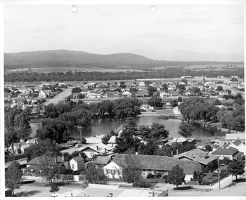
Photo taken from top of clock tower c 1965 looking South West. Black Range in background. Stawell West State School is in the far top right just in front of a band of trees. The swimming pool is hidden by pine trees in the center of the lake and identified but a line of flag posts either side of the pool.Aerial black and white view of Cato lake. One photo is original and the other a copy. The photo was taken from the top of the clock tower looking South West. c 1965.stawell, streetscape -
Stawell Historical Society Inc
Map, Crocodile Gold Corp, Photographic Aerial View of Big Hill showing underground workings and surface workings and proposed Big Hill Open Pit proposal, December 2014
Crocodile Gold Corp SGM photo Map showing Magdala Decline& Wonga Decline December 2014 Produced for Public Consultation over Big Hill Open Pit Proposal. Aerial Views Stawellmining, gold, map -
Stawell Historical Society Inc
Map, Stawell Gold Mine, Stawell Gold Mine Photo Map of Stawell Township showing Underground Declines in mining lease, 2007
... grampians mining gold map Aerial Views Stawell SGM photo Map 2007 ...SGM photo Map 2007 Produced for Public Consultation over Big Hill Open Pit Proposal. Aerial Views Stawellmining, gold, map -
Whitehorse Historical Society Inc.
Map, Aerial Photographs Nunawading, 1970
... numbered from East to West. See table of index and photo numbers ...State Aerial Survey, Melbourne 1970.State Aerial Survey, Melbourne 1970. Project runs 34 - 39 - City of Nunawading. Frames numbered from South to North boundaries, each strip numbered from East to West. See table of index and photo numbers attached.non-fictionState Aerial Survey, Melbourne 1970.state aerial survey, aerial photographs, nunawading, mitcham, blackburn, blackburn north, blackburn south, forest hill, vermont, burwood east, vermont south -
Whitehorse Historical Society Inc.
Map, Aerial maps, 2/04/1966 12:00:00 AM
Melbourne 1966 project, runs 10A and 11A, lens 122 151.75 mm 9,800. Photo nos 77, 107, 109, 161, 163, 165.Melbourne 1966 project, runs 10A and 11A, lens 122 151.75 mm 9,800. Photo nos 77, 107, 109, 161, 163, 165. Areas and boundaries: Map no 77 W. Park and Cook Roads; E. Dubon Rd; N Oban Rd; S Reilly St. Map No 107. W. Indra Rd and Pakenham St; E. Rooks Rd & McLares Rd; N. Maroondah Hwy; S. Hawthorn Rd & Eley Rd. Map No 109 W. Elgar Rd. E. Blackburn Rd & McKean St; S. Eley Rd & Burwood Hwy. Map No 161. W. Elgar Rd & Huntingdale Rd; E. Blackburn Rd; N. Burwood Hwy; S. Waverley Rd. Map No 163. W. Blackburn Rd; S. Springvale Rd; N. Eley Rd & Hawthorn Rd; S. Glen Waverley Railway Line. Map No 165. W. Stanley Rd, Vermont South; E. Cathies Lane, Wantirna South; N. North of Burwood Hwy; S. High Street. Melbourne 1966 project, runs 10A and 11A, lens 122 151.75 mm 9,800. Photo nos 77, 107, 109, 161, 163, 165. aerial photographs, blackburn, blackburn south, forest hill, nunawading, box hill, burwood, burwood east, donvale, mount waverley, glen waverley, wantirna, vermont south, mitcham, ringwood north, ringwood -
 Rutherglen Historical Society
Photograph - Aerial Images, c2000
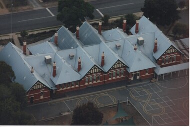
Photograph was probably taken sometime before 2007, as another photo in this series does not show the "Big Red Shed" behind the school. That building is shown on Google Street View shots taken in 2007. Rutherglen Common School No. 522, which is now the Common School Museum, would be to the left of the current school in the photo.Colour aerial photograph of Rutherglen Primary School No. 522, showing the rear of the building and its rooftop.rutherglen primary school, rutherglen state school, school buildings -
 Rutherglen Historical Society
Photograph - Aerial Images, c2000
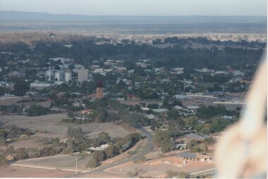
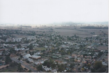
Colour aerial photograph of Rutherglen, viewed from the North East.Written on back of photo: "Water tower (mid) Silos left"rutherglen, rutherglen winebottle, water tower -
 Rutherglen Historical Society
Photograph - Aerial Images, c2000
Colour aerial photograph of Rutherglen, viewed from the South West.Written on back of photo: "St Stevens lower left corner, State School just above | & Glenview, Silos mid left"rutherglen, st stephens church, saint stephens church, rutherglen winebottle, glenview nursing home, rutherglen state school -
 Whitehorse Historical Society Inc.
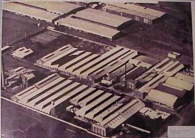
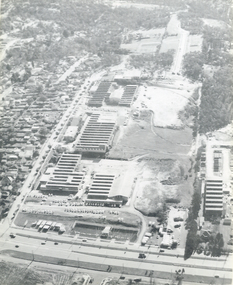
Photograph, Luke Group, 1959
K.G. Luke had a foundry in Queen's Parade, Melbourne which made badges and manufactured items for the Armed Forces during the First World War. He bought 40 acres of cherry orchard in Mitcham in 1952 from a Miss Cook, then went to England and attracted finance from Singer Brass Founders. The company became Luke and Singer. The three factories on site were Luke Manufacturing - stainless steel products and hospital equipment, Luke and Singer - a non-ferrous foundry producing components for industry such as nuts and cutlery, and Concentric Engineering - machinery components. Later the manufacture of refrigeration and air conditioning was added at the rear of the complex. A small aerial photograph and 2 A4 photocopies of the K.G.Luke Group of companies in 1959. The factory site is divided into three groups with Whitehorse Road situated at the bottom of the photo and Cook Road Mitcham to the left. Notes at ND6245luke manufacturing, k.g.luke group, luke and singer, concentric engineering, wheatland, vic, manufacturing industry, foundries, engineering industries -
 Whitehorse Historical Society Inc.
Photograph, Houses of Edgar & Stanley Walker in Mitcham
The house in the top right of the photo was built in 1922 for Edgar Walker. The house at 8 Meerut Street has been used as a hospital, and is on the Whitehorse historical register. The house in the bottom right of the photo was built c1934 for Stanley Walker, at 456 Mitcham Road, Mitcham.Black and white aerial photograph showing the Mitcham houses of Edgar and Stanley Walkerwalker, edgar edwardes, stanley, houses, mitcham road, mitcham, no.456, meerut street, no.8, heritage overlay, city of whitehorse -
 City of Ballarat Libraries
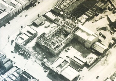
Photograph - Card Box Photographs, Aerial view of the Civic Hall under construction, Ballarat circa 1951
This photo shows the buildings still standing around the Civic Hall as it was being constructed.civic hall, ballarat, mair street, aerial view, armstrong street north, building, construction, public building -
 Inverloch Historical Society
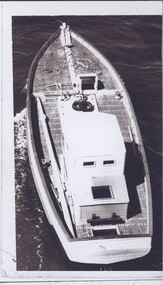
004397 - Photograph - Aerial view of boat possibly Kyeema - on same photo sheet at 4396 - from Bob Young
-
 Magnet Galleries Melbourne Inc
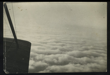
in flight
... , plane, aerial view photo in flight ...photoworld war 1, anzac, ww1, soldiers, australian, plane, aerial view -
 Department of Health and Human Services
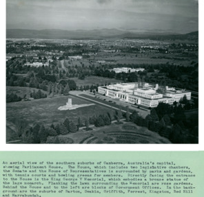
An aerial view of the Southern suburbs of Canberra, Australia's Capital showing Old Parliament House circa 1958 - Department of Health – National Fitness Office (Sports & Recreation) – Historical Press Release Photo Collection
Department of Health – National Fitness Office (Sports & Recreation) – Historical Press Release Photo - Empire Youth Day & Royals on Tour CollectionDepartment of Health – National Fitness Office (Sports & Recreation) – Historical Press Release Photo - Empire Youth Day & Royals on Tour Collection -
 Department of Health and Human Services
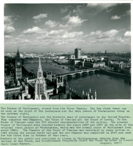
An aerial view with the Houses of Parliament & Big Ben on left of photo August 1957 - Department of Health – National Fitness Office (Sports & Recreation) – Historical Press Release Photo Collection
Department of Health – National Fitness Office (Sports & Recreation) – Historical Press Release Photo - Empire Youth Day & Royals on Tour CollectionDepartment of Health – National Fitness Office (Sports & Recreation) – Historical Press Release Photo - Empire Youth Day & Royals on Tour Collection -
 Department of Health and Human Services
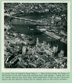
An aerial view of London's River Thames, The Houses of Parliament, and Big Ben - Department of Health – National Fitness Office (Sports & Recreation) – Historical Press Release Photo Collection
Department of Health – National Fitness Office (Sports & Recreation) – Historical Press Release Photo - Empire Youth Day & Royals on Tour CollectionDepartment of Health – National Fitness Office (Sports & Recreation) – Historical Press Release Photo - Empire Youth Day & Royals on Tour Collection -
 Department of Health and Human Services
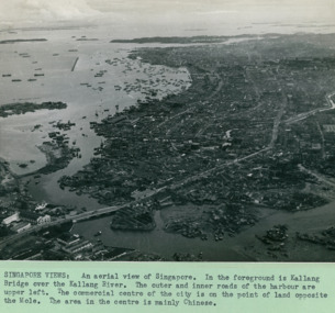
An aerial view of with the Kallang Bridge over the Kallang River in the foreground left Singapore - 3 of 3 photos - Department of Health – National Fitness Office (Sports & Recreation) – Historical Press Release Photo Collection
Department of Health – National Fitness Office (Sports & Recreation) – Historical Press Release Photo - Empire Youth Day & Royals on Tour CollectionDepartment of Health – National Fitness Office (Sports & Recreation) – Historical Press Release Photo - Empire Youth Day & Royals on Tour Collection -
 Southern Sherbrooke Historical Society Inc.
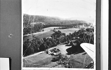
Photograph, Aerial view of Cotswold Valley
Aerial view of Cotswold Valley, Menzies Creek. B&W photos taken from light plane. Paddocks and treed areas are visible. Two houses are in the centre of the photo, presumably the Breen farmhouse on Jacksons Hill Road. The tip of the plane's left wing is also visible. -
Moorabbin Air Museum
Photograph (Item) - Assorted Aerial Photos Of Lae, Rabaul, Horn Island, Kahili, Buna, Gona , Ballale Island
... Moorabbin melbourne Assorted Aerial Photos Of Lae, Rabaul, Horn ... -
Moorabbin Air Museum
Photograph (Item) - Includes photos of Commonwealth aircraft Corp aerial photos, CAC photos of Macchi MB326H trainer Bell 206 Kiowa
... aerial photos ... -
 Ballarat Tramway Museum
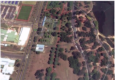
Photograph - Colour Print, Google Earth, Jan. 2015
Yields information about the South Gardens Reserve and the BTM, including Depot Junction following its redevelopment late 2014.Laminated colour photograph of the South Gardens Reserve Precinct, showing the revised depot junction - completed late Dec. 2014, the fish hatchery, the tram depot with Solar panels, Nov. 2014. Image downloaded from Google Earth 31/3/2015. Has a single trucker on 2 road and 939 on 3 road. See images i2 and i3 for other digital photos prepared from Google Earth at the same time. Image i2 has the solar panels marked by a red arrow.trams, tramways, btm, depot junction, aerial views, solar panels, gardens, fish hatchery -
Moorabbin Air Museum
Document (Item) - CAC GAF Fishermens Bend Aerial Photos
... Moorabbin melbourne Document CAC GAF Fishermens Bend Aerial Photos ... -
 Ballarat Tramway Museum
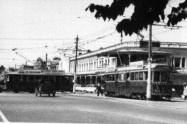
Photograph - Black & White Photograph/s, early 1960's
Black and White print of an aerial view of Bendigo SECV Bendigo tram 18 at Charing Cross terminus for the Eaglehawk route with another bogie tram and two single truck trams in the background. Trams have dash canopy lights, but no large white strip under the drivers windows. Photo not dated but appears to be at during early 1960's. Tram 18 has White Horse Whiskey ad on front dash panel, SEC Roof ads. Numbers of other trams cannot be determined. All trams have roof ads, including SEC ads and a CASTROL ad. Good view of the fountain and buildings on the north east corner. Has Ezywalkin store, City Club Hotel and other buildings. Shows traffic arrangements for cars to do a right turn from Pall Mall into Mitchell St. On a building in Mitchell St. is an advertisement for "ASTOR Radio"trams, tramways, charing cross, bendigo, mitchell st, aerial views, tram 18 -
 Ballarat Tramway Museum
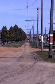
Slide - 35mm slide/s - set of 3, Mark Plummer, Sep. 1971
Series of three photos of Ballarat No. 17, northbound or inbound in Albert St. Sebastopol, approaching the Ophir St. crossing of Albert St. Note tram stop signs, aerial phone lines, the condition of the track and the gravel crossings. Tram has the destination of Lydiard St. North. Kodak cardboard mount slide, taken Mark Plummer, September 1971tramways, trams, albert st, sebastopol, ophir st, tram 17