Showing 766 items
matching afternoon
-
 Eltham District Historical Society Inc
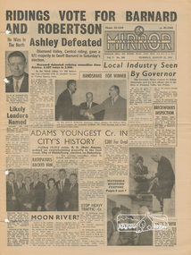
Newspaper, Diamond Valley Mirror, Tuesday, August 31, 1965
Includes Newspaper article on page three "Living Memorial Is Trust's Gift To A Shire" a second clipping of which is also attached to cardboard for display purposes. Article includes text and photographs. Living Memorial is Trust's Gift To A Shire Bathed in bright sunshine and now at its best, the Memorial Garden of the Eltham War Memorial provided a perfect setting for the handing over of the Memorial to the people of Eltham last Saturday afternoon. Speaking for the War Memorial Trust, Mr E. P. Harmer, chairman paid tribute to the unselfishh service given by its members , some for more than 20 years. Special tribute was paid to the late Mrs Ada Lyon, a foundation member who, Mr Harmer said, made the Trust her life. A memorial plaque to Mrs Lyon was unveiled by foundation members Mr N. Kerr. Facilities. An infant welfare centre, a pre-school cente and a children's library are built within the memorial. Funds for the buildings were raised by the Trust and theh women's auxiliary. Accepting the Memorial on behalf of the people of the Shire, the Shire President, Cr. L. C. Docksey, assessed the value at beyond £50,000. To make the transaction legal, Cr. Docksey paid the sum of £1 to the Trust. Many foundation members of the Trust and councillors of the Shire were among the official guests. The Shire of Eltham Brass Band provided suitable background music for the ceremony and at. (remaining part of article is missing) Photo: Mrs C RAINS signs the agreement on behalf of the Eltham War Memorial Trust, transferring the Memorial to the Shire of Eltham, as Mr L. Virgo, secretary of the Trust, affixes the seal and Mr. E. P. Harmer, chairman, accepts payment of £1 from Cr. L. C. Docksey, Shire President. In the background are Mrs Harmer, Cr. T. Collins and Mr S. Addison. Accepting the Memorial on behalf of the people of the Shire was Cr. Docksey's last official duty as President. Separate article on the clipping includes the heading: President Rests in Comfort with a photograph and text: A Tribute to Cr. A. K.Lines, first President of the Shire of Diamond Valley, was paid by fellow councilors last Tuesday night. Acting on behalf of all members of the council, Cr. George Upton, in presenting Cr Lines with an armchair, expressed gratitude for his guidance and assistance to the new shire. Newspaper, 12 pages with four holes punched through near centre margin.eltham war memorial building,eltham war memorial trust,eltham pre-school,e. p. harmer,mrs ada lyon,mrs n. kerr,cr. l. c. docksey,shire of eltham brass band,cr. a. k. lines,diamond valley mirror,1965,cr t. collins,mr. s. addison -
 Old Colonists' Association of Ballarat Inc.
Sydney W. J. Clark House, Charles Anderson Grove, Ballarat
The Old Colonists' Association Ballarat Inc. is a not for profit charitable organisation providing accommodation for elderly people. It manages a 27 Home retirement village at Charles Anderson Grove Ballarat. Accommodation is offered at significantly below market rates. It has been providing low cost accommodation to the elderly since the 1920s. The Association Council overseas the running of this facility on a voluntary basis. "GIFT COTTAGES.- Ballarat Old Colonists Benefit BALLARAT.— High tribute to the good citizenship of Mr. and Mrs. F. J. Williams, now of Melbourne, and Mr. S. Clark, of Ballarat. was paid by a representative gathering at Gillies-street on Thursday afternoon, when the two cottages respectively presented by them for the use of old and indigent colonists were handed over to the council of the Ballarat Old Colonists' Association. The cottages are handsome brick structures, modern in design and equipment, and cost about £650 each. Mr. A. H. Nevett, president of the Ballarat organisation, expressed the gratification of the association at the commencement of a scheme of cottages for old colonists, which had been the aim of the association for many years. Mr. Williams said that when in Ballarat he had been in many public movements as President of South-street and president of the amalgamtion (sic) movement, but in giving this cottage for the use of the old people he had established a tangible and definite link between himself and Ballarat. Similar sentiments were expressed by Mr. Clark, who said his benefaction had given him a great and genuine pleasure. Both donors were warmly thanked on be half of citizens generally by the mayor (Cr. A. E. Nicholson). At subsequent social gathering appropriate toasts were honored, and assurances were given that the association's scheme for 50 gift cottages on the lines of Melbourne would be furthered by several in the not far distant future. (The Age, 30 October 1925.) OBITUARY MR. SIDNEY W. J. CLARK BALLARAT, Friday. - After a long illness Mr. Sidney W. J. Clark, 76, a member of the Courier Pty. Ltd., died at Ballarat today. He was a son of the late Mr. Robert Clark, one of the founders of the journal. Mr. Clark was president of the Ballarat Bowling Club for 10 years, and was a member of the Australian bowling team that visited Britain some years ago. He was a benefactor to Ballarat charities, and gave a cottage to the Ballarat Old Colonists' Association Cottage Scheme. (The Argus, 27 December 1941.)s. clark, sidney clark, sidney w.j. clark, old colonists' association, ballarat old colonists' club, charles anderson grove, philanthropy -
 Kew Historical Society Inc
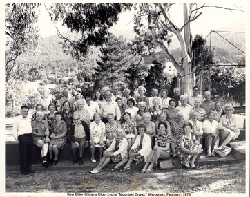
Photograph - Kew Elder Citizens' Club, Lyons 'Mountain Grand' Warburton, Unknown, 1978
The orthodox version of the origins and history of the Kew Elder(ly) Citizens’ Association was established by Cr. W. D. Vaughan in his book Kew’s Civic Century (1960), when he wrote that: "When Mrs. C. H. Simpson was Mayoress in 1952 she set up the Elderly Citizens’ Association to care for the needs of ages persons in Kew. The idea was strongly supported and a start was made by providing social afternoons for elderly folk at Southesk. Visiting sick people in their homes, providing firewood where needed, and other activities were undertaken by the Association. The aid of Council was sought to further the work. It was decided that a social unit for elderly folk be established at Southesk." (p.126-7). In the following pages, he describes in detail Council’s role in formally establishing the Association. This ‘official’ version was reasserted in the later Thematic Environmental History of the City of Boroondara (2012). However the origins and gestation of community of organisations is rarely straightforward. In 1965, five years after Vaughan’s book was published, the author of East Kew Women’s Club : Twenty Years : 20-7-1945-30-7-1965, writing about the period July 1947 to July 1950, described the role the Club played in establishing the Kew Elder Citizens Association. The author wrote: "At a meeting of the Kew Community Aid, the plight of many elderly people in Kew who were dependent on pensions was raised and in order to ascertain their needs the practice was begun of serving morning tea at the Masonic Hall in Walpole Street, where pensions were then paid. From this beginning the Kew Elder Citizens Association was formed in Kew with wide support, and Club members gave willing support on the committee, in helping serve afternoon tea and in entertainment." (p.4) Photographic evidence also leads to questions about Vaughan’s version of events. A framed photograph in the Society’s Collection shows a Public Meeting to form the Kew Elder Citizens Association in a room at Southesk a year earlier in 1951. Whatever version of the origins of the Association is correct, a later framed photograph in the Society’s collection shows the opening of the completed Clubrooms of the Kew Elder Citizens at South Esk by the Hon. E.P. Cameron M.L.C, Minister of Health, on 12 November 1956. The Association is still active in Kew and is currently located at Hamer Court, opposite the Boroondara General (Kew) Cemetery in High Street, Kew.Framed and titled black and white photograph taken on the occasion of a visit by members of the Kew Elder Citizens Club to Lyons "Mountain Grand" Warburton, in February 1978.community groups -- kew (vic.), senior citizens clubs -- kew (vic), club tours -
 Kew Historical Society Inc
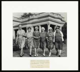
Photograph - Finalists in the 'Queen Competition' at Southesk, Kew Elder Citizens' Club, 1967
The orthodox version of the origins and history of the Kew Elder(ly) Citizens’ Association was established by Cr. W. D. Vaughan in his book Kew’s Civic Century (1960), when he wrote that: "When Mrs. C. H. Simpson was Mayoress in 1952 she set up the Elderly Citizens’ Association to care for the needs of ages persons in Kew. The idea was strongly supported and a start was made by providing social afternoons for elderly folk at Southesk. Visiting sick people in their homes, providing firewood where needed, and other activities were undertaken by the Association. The aid of Council was sought to further the work. It was decided that a social unit for elderly folk be established at Southesk." (p.126-7). In the following pages, he describes in detail Council’s role in formally establishing the Association. This ‘official’ version was reasserted in the later Thematic Environmental History of the City of Boroondara (2012). However the origins and gestation of community of organisations is rarely straightforward. In 1965, five years after Vaughan’s book was published, the author of East Kew Women’s Club : Twenty Years : 20-7-1945-30-7-1965, writing about the period July 1947 to July 1950, described the role the Club played in establishing the Kew Elder Citizens Association. The author wrote: "At a meeting of the Kew Community Aid, the plight of many elderly people in Kew who were dependent on pensions was raised and in order to ascertain their needs the practice was begun of serving morning tea at the Masonic Hall in Walpole Street, where pensions were then paid. From this beginning the Kew Elder Citizens Association was formed in Kew with wide support, and Club members gave willing support on the committee, in helping serve afternoon tea and in entertainment." (p.4) Photographic evidence also leads to questions about Vaughan’s version of events. A framed photograph in the Society’s Collection shows a Public Meeting to form the Kew Elder Citizens Association in a room at Southesk a year earlier in 1951. Whatever version of the origins of the Association is correct, a later framed photograph in the Society’s collection shows the opening of the completed Clubrooms of the Kew Elder Citizens at South Esk by the Hon. E.P. Cameron M.L.C, Minister of Health, on 12 November 1956. The Association is still active in Kew and is currently located at Hamer Court, opposite the Boroondara General (Kew) Cemetery in High Street, Kew.Historic early photograph from the archives of the Kew Elder Citizen's ClubFramed photograph of six women who it is presumed were the candidates or finalists in a competition to be the Queen of Southesk. At this time, Southesk in Cotham Road was home to the Kew Elder Citizens Club, now known as Kew Senior Citizens Centre Inc.Front mount: "Queen Competition 1967 - South Esk - Won by Mrs Harkansee." Reverse: "L-R: -. Miss Knox, Mrs Emmerson, Mrs Higgins, Mrs Moyle, Mrs Harkansee"kew elder citizens club, kew senior citizens centre inc., southesk, miss knox, mrs emmerson, mrs higgins, mrs moyle, mrs harkensee -
 Kew Historical Society Inc
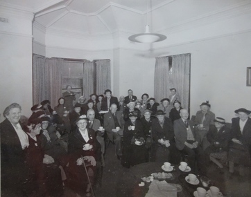
Photograph - Opening of the Kew Elder Citizens Clubrooms at 'Southesk', City of Kew, 1954
The orthodox version of the origins and history of the Kew Elder(ly) Citizens’ Association was established by Cr. W. D. Vaughan in his book Kew’s Civic Century (1960), when he wrote that: "When Mrs. C. H. Simpson was Mayoress in 1952 she set up the Elderly Citizens’ Association to care for the needs of ages persons in Kew. The idea was strongly supported and a start was made by providing social afternoons for elderly folk at Southesk. Visiting sick people in their homes, providing firewood where needed, and other activities were undertaken by the Association. The aid of Council was sought to further the work. It was decided that a social unit for elderly folk be established at Southesk." (p.126-7). In the following pages, he describes in detail Council’s role in formally establishing the Association. This ‘official’ version was reasserted in the later Thematic Environmental History of the City of Boroondara (2012). However the origins and gestation of community of organisations is rarely straightforward. In 1965, five years after Vaughan’s book was published, the author of East Kew Women’s Club : Twenty Years : 20-7-1945-30-7-1965, writing about the period July 1947 to July 1950, described the role the Club played in establishing the Kew Elder Citizens Association. The author wrote: "At a meeting of the Kew Community Aid, the plight of many elderly people in Kew who were dependent on pensions was raised and in order to ascertain their needs the practice was begun of serving morning tea at the Masonic Hall in Walpole Street, where pensions were then paid. From this beginning the Kew Elder Citizens Association was formed in Kew with wide support, and Club members gave willing support on the committee, in helping serve afternoon tea and in entertainment." (p.4) Photographic evidence also leads to questions about Vaughan’s version of events. A framed photograph in the Society’s Collection shows a Public Meeting to form the Kew Elder Citizens Association in a room at Southesk a year earlier in 1951. Whatever version of the origins of the Association is correct, a later framed photograph in the Society’s collection shows the opening of the completed Clubrooms of the Kew Elder Citizens at South Esk by the Hon. E.P. Cameron M.L.C, Minister of Health, on 12 November 1956. The Association is still active in Kew and is currently located at Hamer Court, opposite the Boroondara General (Kew) Cemetery in High Street, Kew.Framed, inscribed photograph of the opening of the Kew Elder Citizens Club at Southesk in 1954. The ceremony would appear to be conducted on the western side of the house.‘Opening of the Kew Elder Citizens Clubrooms “South Esk” by the Hon. E.P. Cameron M.L.C, Minister of Health, 12.11.1956. Cr. W.A. Comeadow O.B.E., J.P. (Mayor).’southesk, kew elder citizens club, kew elderly citizens club, kew senior citizens club -
 Kew Historical Society Inc
Photograph - Public Meeting to Form Kew Elder Citizens' Club, City of Kew, 1951
The orthodox version of the origins and history of the Kew Elder(ly) Citizens’ Association was established by Cr. W. D. Vaughan in his book Kew’s Civic Century (1960), when he wrote that: "When Mrs. C. H. Simpson was Mayoress in 1952 she set up the Elderly Citizens’ Association to care for the needs of ages persons in Kew. The idea was strongly supported and a start was made by providing social afternoons for elderly folk at Southesk. Visiting sick people in their homes, providing firewood where needed, and other activities were undertaken by the Association. The aid of Council was sought to further the work. It was decided that a social unit for elderly folk be established at Southesk." (p.126-7). In the following pages, he describes in detail Council’s role in formally establishing the Association. This ‘official’ version was reasserted in the later Thematic Environmental History of the City of Boroondara (2012). However the origins and gestation of community of organisations is rarely straightforward. In 1965, five years after Vaughan’s book was published, the author of East Kew Women’s Club : Twenty Years : 20-7-1945-30-7-1965, writing about the period July 1947 to July 1950, described the role the Club played in establishing the Kew Elder Citizens Association. The author wrote: "At a meeting of the Kew Community Aid, the plight of many elderly people in Kew who were dependent on pensions was raised and in order to ascertain their needs the practice was begun of serving morning tea at the Masonic Hall in Walpole Street, where pensions were then paid. From this beginning the Kew Elder Citizens Association was formed in Kew with wide support, and Club members gave willing support on the committee, in helping serve afternoon tea and in entertainment." (p.4) Photographic evidence also leads to questions about Vaughan’s version of events. A framed photograph in the Society’s Collection shows a Public Meeting to form the Kew Elder Citizens Association in a room at Southesk a year earlier in 1951. Whatever version of the origins of the Association is correct, a later framed photograph in the Society’s collection shows the opening of the completed Clubrooms of the Kew Elder Citizens at South Esk by the Hon. E.P. Cameron M.L.C, Minister of Health, on 12 November 1956. The Association is still active in Kew and is currently located at Hamer Court, opposite the Boroondara General (Kew) Cemetery in High Street, Kew.Historic founding photograph of the Kew Senior Citizens AssociationFramed photograph of a meeting at Southesk in Cotham Road to form the Kew Elder Citizens Club. None of the individuals are named. The meeting was not held in the Drawing Room or Ballroom at Southesk as there is an absence of frescoes on the ceiling. The ceiling in the photograph is a cove ceiling however like that in the front two rooms.Handwritten caption: "Public Meeting to Form Kew Elder Citizens, 1951"kew elder citizens club, kew elderly citizens club, kew senior citizens club, southesk -
Bendigo Historical Society Inc.
Document - Amy Huxtable Memorial Committee - Correspondence, 1981-90
Amy Huxtable was born at Cheltenham in 1918, to Robert Henry Huxtable and Violet A Dagg. Her father was an installer for an oil company and travelled the State. taking his family with him. She completed her education at the Bendigo High School and later attended the Bendigo Business College, becoming an expert shorthand writer. Her first position was as a copy writer with Radio 3BO, in the mid 1930s. She worked with an advertising agency in Melbourne and then with the Age,newspaper. In 1953, Miss Huxtable was appointed temporarily to succeed Miss E B Millane as social editress of the Bendigo Advertiser, during the latter's absence abroad. In 1956, Amy travelled abroad and on her return in 1957 was appointed permanently as Women's editor, a position she held for twenty-three ears. During her early years with The Advertiser she wrote under the name Toora, but in later years her own name became widely known. Miss Huxtable was well known both in her professional capacity and through a interest and involvement in community activites. She was life governor of the Bendigo Hospital, the Bendigo Home for the Aged, and Mirridong Home for the Blind, she was a member of Soroptimist International and the Business and Professional Women's Club. Amy was also a tireless worker for the spastic society and a strong supporter of the YWCA. When Amy Huxtable died at Mt AJvernia Hospital on 16 January 1980 Mayor Campbell ordered the city flag to be flown at half-mast. "Lowering the flag is the least we can do for such a lady" Cr Campbell said. Douglas Lockwood, editor of the Bendigo Advertiser said, "She was a devot d colleague who gave her craft and her newspaper the kind of service which identified a rare and generous spirit." She was a true professional who decided to make Bendigo her home. More than 300 people packed St Paul's Church for her funeral ervice the bell tolled as the casket was carried from the church. At a ceremony in the Conservatory Gardens on No ember 22 1981 The Amy Huxtable Memorial Committee presented to the City of Bendigo, a garden seat in memory of the late Miss Huxtable. This Bendigo manufactured seat was a fitting tribute to one ofBendigo's most loved and esteemed citizens. All Miss Huxtable's Advertiser articles were microfilmed and presented to the Library by the above committee. Amy Huxtable Memorial Committee - Correspondence - 18 Pages Page 1 Letter to Andrew Taylor, Superintendent, Bendigo City Parks and Gardens 2/6/1981 re siting of the Memorial Seat. Page 2 Reply to the above letter 2/7/1981 Page 3-4 Letter to the Council suggesting the seat be placed in the Conservatory gardens 7/7/1981 Page 5 Letter from the committee to Denis O'Hoy thanking them for supplying clay and plaster for the prep work 7/7/1981 Page 6 Letter from Andrew Taylor, Bendigo City Council 22/7/1981 advising the committee that the council has approved two seats and a vandal proof sign be placed up against the Conservatory facing the Bendigo Advertiser offices. Page 7 Letter 14/8/1981 from the committee to the council re the plaque design Page 8 To the Bendigo council 8/9/1981 suggesting a date and time for the handover of the seat. Page 9 From the council 12/10/1981 thankyou letter from the Mayor agreeing to the time of the memorial seat handover. Page 10 Letter back to the Mayor on 10/7/1981 from the committee with a suggested program for the afternoon. Page 11-13 Letter from the committee to BCV TV Channel 8 10/11/1981, asking them to advertise the event on their community noticeboard, the wording enclosed; and also an article for the news. Page 14-15 The wording on the plaque Page 16 Letter to the Bendigo Council 16/8/1984 asking for some repairs to be done to the seat due to weathering. Page 16 Letter back from the council 23/8/1984 advising the committee that it is on the list of maintenance for later in the year. Page 17 Letter from the Bendigo Regional Arts Centre to the committee 28/6/1990 adising receipt of $1000 for seats ion the re-vamperd Capital Theatre; seat inscription to be "Donated by:- Amy Huxtable Memorial Committee In Memory of :- Amy Huxtablehistory, amy huxtable, bendigo, amy huxtable memorial committee, bendigo conservatory gardens, capital theatre, bendigo regional arts centre -
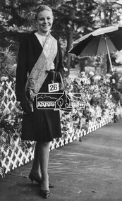 Eltham District Historical Society Inc
Photograph, Joy Chapman, Miss Eltham, April 1965, Apr 1965
My Recollections of Eltham Past by Margaret Joy Harding (nee Joy Chapman.) My family of Elizabeth and Alec Chapman moved to Eltham in 1946 into a cottage on the opposite side of the Diamond Creek from where the little train now operates in the Lower Park. At that time Eltham truly was a country town and the Pub was the main meeting place for most inhabitants on a Saturday afternoon in the beer garden. I attended Eltham Primary School where I started as a 4-year-old (my birthday being slightly after the mid-year intake) that happened then. My mother spent a lot of days taking me back to school when I had dismissed myself and walked the one kilomtre home alone. Bremner's Common (now Wingrove Park) was a big attraction with its dam and tad poling which I found much more entertaining than school. (Mrs Bremner ran a Service Station on the site of the current one). Another attraction at this site was the circus that came a couple of times a year. Watching them put up the circus tent was very interesting and even more of an attraction was the feeding of the Lions in cages and the monkeys and elephants among the other animals that are not found in a circus these days. At school then we were provided with hot chocolate at morning recess where the mothers would prepare it in the shelter shed. The only form of classroom heating was an open fire. Worse was the warm milk given in the summer months. By the time I was near finishing at Primary school we used to be able to walk along the Main Road at lunchtime to Mrs. Mitchell's shop to a delicious hot pie. As I recall there was no supervision for this departure from the school grounds. It is interesting that some of the other children I started school with I still have contact with, in fact one is a very good friend although now living in Perth. That is the other thing about Eltham; many who grew up here continue to live in the area. Following primary school, the natural progression was to Eltham High School. There was only the main building at that time and I can remember our first assembly at the front entrance. During the time I was at High School several new class rooms were added and the school hall. I remember the musical plays such as HMS Pinafore and other classical musicals being performed. I also remember countless hours doing marching practice. The main street shops when I was young consisted of the Blue Gum milk bar at the far end, a Grocery store and a shoe maker where Coles currently stands. Opposite there was Lyon's Garage. They also provided a bus service and when we got off the train this little bus would tour the back streets taking each individual to their home, sometimes this could take quite considerable time. There was also a Black Smith next to the Chiropractic Practice opposite Alistair Knox Park, another Milk Bar/General Store on the comer of Bridge Street/Main Road where a shop currently still operates. There was also a Butcher's shop down from the pub opposite Franklin Street. The only doctor was next to the courthouse on the other side of Brougham Street. On Saturday afternoon I was occasionally allowed to go the movies in the Town Hall which also stood on the site of the Coles centre. Often the Fire Alarm would sound and everyone would run outside to watch the fire truck leave with the volunteers clutching on the back. The other attraction during summer of course was the swimming pool which was a small concrete pool filled with water pumped from the Diamond Creek, sometimes it was like a mud puddle so for me the nearer to home Yarra/Diamond Creek junction was a much better option. We swam in the water hole which was quite deep and with fallen trees and sometimes carcasses of cows and kangaroos floating past. As recreation, the churches were another attraction for the Sunday school picnics to Mordialloc in the back of the moving van with benches tied into the back for us to "sit" on. Too bad when we went around a corner! In the early days we had an Ice Man deliver the ice once a week for "refrigeration". The green grocer came around in a horse and cart as did the milkman and the bread was delivered but I constantly got into trouble for eating the middle out on the way from the box it was delivered to in Mt Pleasant road across the paddock. The milkman finally would not come down our street after his horse bolted one morning and took off across the paddock. We also had the "Pan Man" come weekly and whose visit I would avoid. Our nearest shop was where the flower stall is located opposite the Lower Park. It consisted of a Tea Room and Milk Bar. There was a Public Telephone there which was the only contact to anyone else. We were a one car family so my mother’s movements were very limited as the Eltham Station was a couple of kilometres away and a trip to the city was an event. Being an only child growing up was a little lonely however rambling along the creek with my Mum, picking mushrooms and picking cherry plums for jam and the dogs catching rabbits which we ate if we could get them away from the dogs. We also liked to go into the Lower Park during school holidays when the Greek people came to camp and they would sing and dance around the camp fire and it all seemed so different to us as this was early days of immigration. Childhood was relatively simple and carefree and I wish the kids of today had the freedom of my youth and the healthy outdoor lifestyle of the "olden days". SHOW GIRL COMPETITION In 1965 Eltham was more like a country town than the suburb it has become today. People knew each other, if not personally then certainly of the family name. The big event for the year was a Gymkhana or show at Lower Eltham Park. I can remember marching as a teenager from the town centre to the park in the marching girls with the decorated floats. In 1965, just on a whim on the day, I decided to enter the Miss Eltham Show Girl which was a part of the festivities at the park. I seem to remember that the show mainly consisted of horse events, cattle judging and dog show. As I had not given any serious thought to entering the competition, I wore a suit that I had for work which was brown wool, with a coffee coloured shirt under, black shoes, bag, and gloves but no hat. I duly paraded for the judges and much to my surprise I was announced the winner. I eventually went on to compete at the Miss Victoria Show Girl competition which was held at the Royal Melbourne Show. There I met many country girls who were representing their rural Victoria home. I made it into a final round of judging but I think justice prevailed when someone from a country background was crowned. It was fun to go into the show as I had not really been before and to see the displays of handcraft, cooking and wood chopping events was great as well as the judging of farm animals interesting. It is hard to remember the Eltham I grew up in. The Lyons Garage company bus that actually drove you home (or close to it) when we got off the train at night. The Eltham Hotel on a Saturday afternoon a usual social meeting place where people just sat and chatted. The pictures held in the Town Hall and when the fire alarm sounded all the men just jumped up and ran to help. Suburbia has now swallowed most of that life but thankfully we at least do have the trestle bridge and parkland. Digital file only - Black and white photo print on loan for scanning by EDHSalec chapman, annie bremner, blacksmith, bremner's flat, brougham steet, bus services, circus, diamond creek, dianne bell, doctor bradbury, easter gymkhana, elizabeth chapman, eltham high school, eltham hotel, eltham lower park, eltham public hall, eltham state school, eltham trestle bridge, general store, grace mitchell, ice man, joy chapman, lyons garage, margaret harding, milk bar, miss eltham 1965, miss victoria show girl, mount pleasant road, pan man, rodda parade, shops, show girl competition, swimming pool, water hole, yarra river -
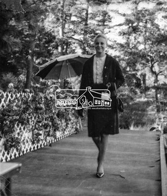 Eltham District Historical Society Inc
Photograph, Joy Chapman parading before the judges, Miss Eltham 1965, Apr 1965
My Recollections of Eltham Past by Margaret Joy Harding (nee Joy Chapman.) My family of Elizabeth and Alec Chapman moved to Eltham in 1946 into a cottage on the opposite side of the Diamond Creek from where the little train now operates in the Lower Park. At that time Eltham truly was a country town and the Pub was the main meeting place for most inhabitants on a Saturday afternoon in the beer garden. I attended Eltham Primary School where I started as a 4-year-old (my birthday being slightly after the mid-year intake) that happened then. My mother spent a lot of days taking me back to school when I had dismissed myself and walked the one kilomtre home alone. Bremner's Common (now Wingrove Park) was a big attraction with its dam and tad poling which I found much more entertaining than school. (Mrs Bremner ran a Service Station on the site of the current one). Another attraction at this site was the circus that came a couple of times a year. Watching them put up the circus tent was very interesting and even more of an attraction was the feeding of the Lions in cages and the monkeys and elephants among the other animals that are not found in a circus these days. At school then we were provided with hot chocolate at morning recess where the mothers would prepare it in the shelter shed. The only form of classroom heating was an open fire. Worse was the warm milk given in the summer months. By the time I was near finishing at Primary school we used to be able to walk along the Main Road at lunchtime to Mrs. Mitchell's shop to a delicious hot pie. As I recall there was no supervision for this departure from the school grounds. It is interesting that some of the other children I started school with I still have contact with, in fact one is a very good friend although now living in Perth. That is the other thing about Eltham; many who grew up here continue to live in the area. Following primary school, the natural progression was to Eltham High School. There was only the main building at that time and I can remember our first assembly at the front entrance. During the time I was at High School several new class rooms were added and the school hall. I remember the musical plays such as HMS Pinafore and other classical musicals being performed. I also remember countless hours doing marching practice. The main street shops when I was young consisted of the Blue Gum milk bar at the far end, a Grocery store and a shoe maker where Coles currently stands. Opposite there was Lyon's Garage. They also provided a bus service and when we got off the train this little bus would tour the back streets taking each individual to their home, sometimes this could take quite considerable time. There was also a Black Smith next to the Chiropractic Practice opposite Alistair Knox Park, another Milk Bar/General Store on the comer of Bridge Street/Main Road where a shop currently still operates. There was also a Butcher's shop down from the pub opposite Franklin Street. The only doctor was next to the courthouse on the other side of Brougham Street. On Saturday afternoon I was occasionally allowed to go the movies in the Town Hall which also stood on the site of the Coles centre. Often the Fire Alarm would sound and everyone would run outside to watch the fire truck leave with the volunteers clutching on the back. The other attraction during summer of course was the swimming pool which was a small concrete pool filled with water pumped from the Diamond Creek, sometimes it was like a mud puddle so for me the nearer to home Yarra/Diamond Creek junction was a much better option. We swam in the water hole which was quite deep and with fallen trees and sometimes carcasses of cows and kangaroos floating past. As recreation, the churches were another attraction for the Sunday school picnics to Mordialloc in the back of the moving van with benches tied into the back for us to "sit" on. Too bad when we went around a corner! In the early days we had an Ice Man deliver the ice once a week for "refrigeration". The green grocer came around in a horse and cart as did the milkman and the bread was delivered but I constantly got into trouble for eating the middle out on the way from the box it was delivered to in Mt Pleasant road across the paddock. The milkman finally would not come down our street after his horse bolted one morning and took off across the paddock. We also had the "Pan Man" come weekly and whose visit I would avoid. Our nearest shop was where the flower stall is located opposite the Lower Park. It consisted of a Tea Room and Milk Bar. There was a Public Telephone there which was the only contact to anyone else. We were a one car family so my mother’s movements were very limited as the Eltham Station was a couple of kilometres away and a trip to the city was an event. Being an only child growing up was a little lonely however rambling along the creek with my Mum, picking mushrooms and picking cherry plums for jam and the dogs catching rabbits which we ate if we could get them away from the dogs. We also liked to go into the Lower Park during school holidays when the Greek people came to camp and they would sing and dance around the camp fire and it all seemed so different to us as this was early days of immigration. Childhood was relatively simple and carefree and I wish the kids of today had the freedom of my youth and the healthy outdoor lifestyle of the "olden days". SHOW GIRL COMPETITION In 1965 Eltham was more like a country town than the suburb it has become today. People knew each other, if not personally then certainly of the family name. The big event for the year was a Gymkhana or show at Lower Eltham Park. I can remember marching as a teenager from the town centre to the park in the marching girls with the decorated floats. In 1965, just on a whim on the day, I decided to enter the Miss Eltham Show Girl which was a part of the festivities at the park. I seem to remember that the show mainly consisted of horse events, cattle judging and dog show. As I had not given any serious thought to entering the competition, I wore a suit that I had for work which was brown wool, with a coffee coloured shirt under, black shoes, bag, and gloves but no hat. I duly paraded for the judges and much to my surprise I was announced the winner. I eventually went on to compete at the Miss Victoria Show Girl competition which was held at the Royal Melbourne Show. There I met many country girls who were representing their rural Victoria home. I made it into a final round of judging but I think justice prevailed when someone from a country background was crowned. It was fun to go into the show as I had not really been before and to see the displays of handcraft, cooking and wood chopping events was great as well as the judging of farm animals interesting. It is hard to remember the Eltham I grew up in. The Lyons Garage company bus that actually drove you home (or close to it) when we got off the train at night. The Eltham Hotel on a Saturday afternoon a usual social meeting place where people just sat and chatted. The pictures held in the Town Hall and when the fire alarm sounded all the men just jumped up and ran to help. Suburbia has now swallowed most of that life but thankfully we at least do have the trestle bridge and parkland. Digital file only - Black and white photo print on loan for scanning by EDHSalec chapman, annie bremner, blacksmith, bremner's flat, brougham steet, bus services, circus, diamond creek, dianne bell, doctor bradbury, easter gymkhana, elizabeth chapman, eltham high school, eltham hotel, eltham lower park, eltham public hall, eltham state school, eltham trestle bridge, general store, grace mitchell, ice man, joy chapman, lyons garage, margaret harding, milk bar, miss eltham 1965, miss victoria show girl, mount pleasant road, pan man, rodda parade, shops, show girl competition, swimming pool, water hole, yarra river -
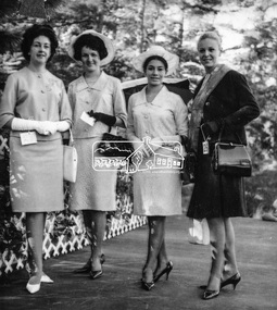 Eltham District Historical Society Inc
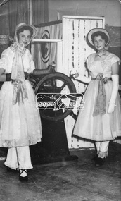
Photograph, Joy Chapman, Miss Eltham 1965 with other contestants, Apr 1965
My Recollections of Eltham Past by Margaret Joy Harding (nee Joy Chapman.) My family of Elizabeth and Alec Chapman moved to Eltham in 1946 into a cottage on the opposite side of the Diamond Creek from where the little train now operates in the Lower Park. At that time Eltham truly was a country town and the Pub was the main meeting place for most inhabitants on a Saturday afternoon in the beer garden. I attended Eltham Primary School where I started as a 4-year-old (my birthday being slightly after the mid-year intake) that happened then. My mother spent a lot of days taking me back to school when I had dismissed myself and walked the one kilomtre home alone. Bremner's Common (now Wingrove Park) was a big attraction with its dam and tad poling which I found much more entertaining than school. (Mrs Bremner ran a Service Station on the site of the current one). Another attraction at this site was the circus that came a couple of times a year. Watching them put up the circus tent was very interesting and even more of an attraction was the feeding of the Lions in cages and the monkeys and elephants among the other animals that are not found in a circus these days. At school then we were provided with hot chocolate at morning recess where the mothers would prepare it in the shelter shed. The only form of classroom heating was an open fire. Worse was the warm milk given in the summer months. By the time I was near finishing at Primary school we used to be able to walk along the Main Road at lunchtime to Mrs. Mitchell's shop to a delicious hot pie. As I recall there was no supervision for this departure from the school grounds. It is interesting that some of the other children I started school with I still have contact with, in fact one is a very good friend although now living in Perth. That is the other thing about Eltham; many who grew up here continue to live in the area. Following primary school, the natural progression was to Eltham High School. There was only the main building at that time and I can remember our first assembly at the front entrance. During the time I was at High School several new class rooms were added and the school hall. I remember the musical plays such as HMS Pinafore and other classical musicals being performed. I also remember countless hours doing marching practice. The main street shops when I was young consisted of the Blue Gum milk bar at the far end, a Grocery store and a shoe maker where Coles currently stands. Opposite there was Lyon's Garage. They also provided a bus service and when we got off the train this little bus would tour the back streets taking each individual to their home, sometimes this could take quite considerable time. There was also a Black Smith next to the Chiropractic Practice opposite Alistair Knox Park, another Milk Bar/General Store on the comer of Bridge Street/Main Road where a shop currently still operates. There was also a Butcher's shop down from the pub opposite Franklin Street. The only doctor was next to the courthouse on the other side of Brougham Street. On Saturday afternoon I was occasionally allowed to go the movies in the Town Hall which also stood on the site of the Coles centre. Often the Fire Alarm would sound and everyone would run outside to watch the fire truck leave with the volunteers clutching on the back. The other attraction during summer of course was the swimming pool which was a small concrete pool filled with water pumped from the Diamond Creek, sometimes it was like a mud puddle so for me the nearer to home Yarra/Diamond Creek junction was a much better option. We swam in the water hole which was quite deep and with fallen trees and sometimes carcasses of cows and kangaroos floating past. As recreation, the churches were another attraction for the Sunday school picnics to Mordialloc in the back of the moving van with benches tied into the back for us to "sit" on. Too bad when we went around a corner! In the early days we had an Ice Man deliver the ice once a week for "refrigeration". The green grocer came around in a horse and cart as did the milkman and the bread was delivered but I constantly got into trouble for eating the middle out on the way from the box it was delivered to in Mt Pleasant road across the paddock. The milkman finally would not come down our street after his horse bolted one morning and took off across the paddock. We also had the "Pan Man" come weekly and whose visit I would avoid. Our nearest shop was where the flower stall is located opposite the Lower Park. It consisted of a Tea Room and Milk Bar. There was a Public Telephone there which was the only contact to anyone else. We were a one car family so my mother’s movements were very limited as the Eltham Station was a couple of kilometres away and a trip to the city was an event. Being an only child growing up was a little lonely however rambling along the creek with my Mum, picking mushrooms and picking cherry plums for jam and the dogs catching rabbits which we ate if we could get them away from the dogs. We also liked to go into the Lower Park during school holidays when the Greek people came to camp and they would sing and dance around the camp fire and it all seemed so different to us as this was early days of immigration. Childhood was relatively simple and carefree and I wish the kids of today had the freedom of my youth and the healthy outdoor lifestyle of the "olden days". SHOW GIRL COMPETITION In 1965 Eltham was more like a country town than the suburb it has become today. People knew each other, if not personally then certainly of the family name. The big event for the year was a Gymkhana or show at Lower Eltham Park. I can remember marching as a teenager from the town centre to the park in the marching girls with the decorated floats. In 1965, just on a whim on the day, I decided to enter the Miss Eltham Show Girl which was a part of the festivities at the park. I seem to remember that the show mainly consisted of horse events, cattle judging and dog show. As I had not given any serious thought to entering the competition, I wore a suit that I had for work which was brown wool, with a coffee coloured shirt under, black shoes, bag, and gloves but no hat. I duly paraded for the judges and much to my surprise I was announced the winner. I eventually went on to compete at the Miss Victoria Show Girl competition which was held at the Royal Melbourne Show. There I met many country girls who were representing their rural Victoria home. I made it into a final round of judging but I think justice prevailed when someone from a country background was crowned. It was fun to go into the show as I had not really been before and to see the displays of handcraft, cooking and wood chopping events was great as well as the judging of farm animals interesting. It is hard to remember the Eltham I grew up in. The Lyons Garage company bus that actually drove you home (or close to it) when we got off the train at night. The Eltham Hotel on a Saturday afternoon a usual social meeting place where people just sat and chatted. The pictures held in the Town Hall and when the fire alarm sounded all the men just jumped up and ran to help. Suburbia has now swallowed most of that life but thankfully we at least do have the trestle bridge and parkland. Digital file only - Black and white photo print on loan for scanning by EDHSalec chapman, annie bremner, blacksmith, bremner's flat, brougham steet, bus services, circus, diamond creek, dianne bell, doctor bradbury, easter gymkhana, elizabeth chapman, eltham high school, eltham hotel, eltham lower park, eltham public hall, eltham state school, eltham trestle bridge, general store, grace mitchell, ice man, joy chapman, lyons garage, margaret harding, milk bar, miss eltham 1965, miss victoria show girl, mount pleasant road, pan man, rodda parade, shops, show girl competition, swimming pool, water hole, yarra river -
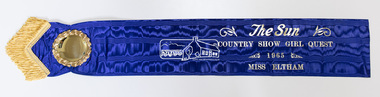 Eltham District Historical Society Inc
Photograph, Peter Pidgeon, The original Miss Eltham 1965 sash, 17 May 2019
My Recollections of Eltham Past by Margaret Joy Harding (nee Joy Chapman.) My family of Elizabeth and Alec Chapman moved to Eltham in 1946 into a cottage on the opposite side of the Diamond Creek from where the little train now operates in the Lower Park. At that time Eltham truly was a country town and the Pub was the main meeting place for most inhabitants on a Saturday afternoon in the beer garden. I attended Eltham Primary School where I started as a 4-year-old (my birthday being slightly after the mid-year intake) that happened then. My mother spent a lot of days taking me back to school when I had dismissed myself and walked the one kilomtre home alone. Bremner's Common (now Wingrove Park) was a big attraction with its dam and tad poling which I found much more entertaining than school. (Mrs Bremner ran a Service Station on the site of the current one). Another attraction at this site was the circus that came a couple of times a year. Watching them put up the circus tent was very interesting and even more of an attraction was the feeding of the Lions in cages and the monkeys and elephants among the other animals that are not found in a circus these days. At school then we were provided with hot chocolate at morning recess where the mothers would prepare it in the shelter shed. The only form of classroom heating was an open fire. Worse was the warm milk given in the summer months. By the time I was near finishing at Primary school we used to be able to walk along the Main Road at lunchtime to Mrs. Mitchell's shop to a delicious hot pie. As I recall there was no supervision for this departure from the school grounds. It is interesting that some of the other children I started school with I still have contact with, in fact one is a very good friend although now living in Perth. That is the other thing about Eltham; many who grew up here continue to live in the area. Following primary school, the natural progression was to Eltham High School. There was only the main building at that time and I can remember our first assembly at the front entrance. During the time I was at High School several new class rooms were added and the school hall. I remember the musical plays such as HMS Pinafore and other classical musicals being performed. I also remember countless hours doing marching practice. The main street shops when I was young consisted of the Blue Gum milk bar at the far end, a Grocery store and a shoe maker where Coles currently stands. Opposite there was Lyon's Garage. They also provided a bus service and when we got off the train this little bus would tour the back streets taking each individual to their home, sometimes this could take quite considerable time. There was also a Black Smith next to the Chiropractic Practice opposite Alistair Knox Park, another Milk Bar/General Store on the comer of Bridge Street/Main Road where a shop currently still operates. There was also a Butcher's shop down from the pub opposite Franklin Street. The only doctor was next to the courthouse on the other side of Brougham Street. On Saturday afternoon I was occasionally allowed to go the movies in the Town Hall which also stood on the site of the Coles centre. Often the Fire Alarm would sound and everyone would run outside to watch the fire truck leave with the volunteers clutching on the back. The other attraction during summer of course was the swimming pool which was a small concrete pool filled with water pumped from the Diamond Creek, sometimes it was like a mud puddle so for me the nearer to home Yarra/Diamond Creek junction was a much better option. We swam in the water hole which was quite deep and with fallen trees and sometimes carcasses of cows and kangaroos floating past. As recreation, the churches were another attraction for the Sunday school picnics to Mordialloc in the back of the moving van with benches tied into the back for us to "sit" on. Too bad when we went around a corner! In the early days we had an Ice Man deliver the ice once a week for "refrigeration". The green grocer came around in a horse and cart as did the milkman and the bread was delivered but I constantly got into trouble for eating the middle out on the way from the box it was delivered to in Mt Pleasant road across the paddock. The milkman finally would not come down our street after his horse bolted one morning and took off across the paddock. We also had the "Pan Man" come weekly and whose visit I would avoid. Our nearest shop was where the flower stall is located opposite the Lower Park. It consisted of a Tea Room and Milk Bar. There was a Public Telephone there which was the only contact to anyone else. We were a one car family so my mother’s movements were very limited as the Eltham Station was a couple of kilometres away and a trip to the city was an event. Being an only child growing up was a little lonely however rambling along the creek with my Mum, picking mushrooms and picking cherry plums for jam and the dogs catching rabbits which we ate if we could get them away from the dogs. We also liked to go into the Lower Park during school holidays when the Greek people came to camp and they would sing and dance around the camp fire and it all seemed so different to us as this was early days of immigration. Childhood was relatively simple and carefree and I wish the kids of today had the freedom of my youth and the healthy outdoor lifestyle of the "olden days". SHOW GIRL COMPETITION In 1965 Eltham was more like a country town than the suburb it has become today. People knew each other, if not personally then certainly of the family name. The big event for the year was a Gymkhana or show at Lower Eltham Park. I can remember marching as a teenager from the town centre to the park in the marching girls with the decorated floats. In 1965, just on a whim on the day, I decided to enter the Miss Eltham Show Girl which was a part of the festivities at the park. I seem to remember that the show mainly consisted of horse events, cattle judging and dog show. As I had not given any serious thought to entering the competition, I wore a suit that I had for work which was brown wool, with a coffee coloured shirt under, black shoes, bag, and gloves but no hat. I duly paraded for the judges and much to my surprise I was announced the winner. I eventually went on to compete at the Miss Victoria Show Girl competition which was held at the Royal Melbourne Show. There I met many country girls who were representing their rural Victoria home. I made it into a final round of judging but I think justice prevailed when someone from a country background was crowned. It was fun to go into the show as I had not really been before and to see the displays of handcraft, cooking and wood chopping events was great as well as the judging of farm animals interesting. It is hard to remember the Eltham I grew up in. The Lyons Garage company bus that actually drove you home (or close to it) when we got off the train at night. The Eltham Hotel on a Saturday afternoon a usual social meeting place where people just sat and chatted. The pictures held in the Town Hall and when the fire alarm sounded all the men just jumped up and ran to help. Suburbia has now swallowed most of that life but thankfully we at least do have the trestle bridge and parkland. Born digitalalec chapman, annie bremner, blacksmith, bremner's flat, brougham steet, bus services, circus, diamond creek, dianne bell, doctor bradbury, easter gymkhana, elizabeth chapman, eltham high school, eltham hotel, eltham lower park, eltham public hall, eltham state school, eltham trestle bridge, general store, grace mitchell, ice man, joy chapman, lyons garage, margaret harding, milk bar, miss eltham 1965, miss victoria show girl, mount pleasant road, pan man, rodda parade, shops, show girl competition, swimming pool, water hole, yarra river -
 Eltham District Historical Society Inc
Photograph, Joy Chapman in rear playground of Eltham High School, 1959, 1959
My Recollections of Eltham Past by Margaret Joy Harding (nee Joy Chapman.) My family of Elizabeth and Alec Chapman moved to Eltham in 1946 into a cottage on the opposite side of the Diamond Creek from where the little train now operates in the Lower Park. At that time Eltham truly was a country town and the Pub was the main meeting place for most inhabitants on a Saturday afternoon in the beer garden. I attended Eltham Primary School where I started as a 4-year-old (my birthday being slightly after the mid-year intake) that happened then. My mother spent a lot of days taking me back to school when I had dismissed myself and walked the one kilomtre home alone. Bremner's Common (now Wingrove Park) was a big attraction with its dam and tad poling which I found much more entertaining than school. (Mrs Bremner ran a Service Station on the site of the current one). Another attraction at this site was the circus that came a couple of times a year. Watching them put up the circus tent was very interesting and even more of an attraction was the feeding of the Lions in cages and the monkeys and elephants among the other animals that are not found in a circus these days. At school then we were provided with hot chocolate at morning recess where the mothers would prepare it in the shelter shed. The only form of classroom heating was an open fire. Worse was the warm milk given in the summer months. By the time I was near finishing at Primary school we used to be able to walk along the Main Road at lunchtime to Mrs. Mitchell's shop to a delicious hot pie. As I recall there was no supervision for this departure from the school grounds. It is interesting that some of the other children I started school with I still have contact with, in fact one is a very good friend although now living in Perth. That is the other thing about Eltham; many who grew up here continue to live in the area. Following primary school, the natural progression was to Eltham High School. There was only the main building at that time and I can remember our first assembly at the front entrance. During the time I was at High School several new class rooms were added and the school hall. I remember the musical plays such as HMS Pinafore and other classical musicals being performed. I also remember countless hours doing marching practice. The main street shops when I was young consisted of the Blue Gum milk bar at the far end, a Grocery store and a shoe maker where Coles currently stands. Opposite there was Lyon's Garage. They also provided a bus service and when we got off the train this little bus would tour the back streets taking each individual to their home, sometimes this could take quite considerable time. There was also a Black Smith next to the Chiropractic Practice opposite Alistair Knox Park, another Milk Bar/General Store on the comer of Bridge Street/Main Road where a shop currently still operates. There was also a Butcher's shop down from the pub opposite Franklin Street. The only doctor was next to the courthouse on the other side of Brougham Street. On Saturday afternoon I was occasionally allowed to go the movies in the Town Hall which also stood on the site of the Coles centre. Often the Fire Alarm would sound and everyone would run outside to watch the fire truck leave with the volunteers clutching on the back. The other attraction during summer of course was the swimming pool which was a small concrete pool filled with water pumped from the Diamond Creek, sometimes it was like a mud puddle so for me the nearer to home Yarra/Diamond Creek junction was a much better option. We swam in the water hole which was quite deep and with fallen trees and sometimes carcasses of cows and kangaroos floating past. As recreation, the churches were another attraction for the Sunday school picnics to Mordialloc in the back of the moving van with benches tied into the back for us to "sit" on. Too bad when we went around a corner! In the early days we had an Ice Man deliver the ice once a week for "refrigeration". The green grocer came around in a horse and cart as did the milkman and the bread was delivered but I constantly got into trouble for eating the middle out on the way from the box it was delivered to in Mt Pleasant road across the paddock. The milkman finally would not come down our street after his horse bolted one morning and took off across the paddock. We also had the "Pan Man" come weekly and whose visit I would avoid. Our nearest shop was where the flower stall is located opposite the Lower Park. It consisted of a Tea Room and Milk Bar. There was a Public Telephone there which was the only contact to anyone else. We were a one car family so my mother’s movements were very limited as the Eltham Station was a couple of kilometres away and a trip to the city was an event. Being an only child growing up was a little lonely however rambling along the creek with my Mum, picking mushrooms and picking cherry plums for jam and the dogs catching rabbits which we ate if we could get them away from the dogs. We also liked to go into the Lower Park during school holidays when the Greek people came to camp and they would sing and dance around the camp fire and it all seemed so different to us as this was early days of immigration. Childhood was relatively simple and carefree and I wish the kids of today had the freedom of my youth and the healthy outdoor lifestyle of the "olden days". SHOW GIRL COMPETITION In 1965 Eltham was more like a country town than the suburb it has become today. People knew each other, if not personally then certainly of the family name. The big event for the year was a Gymkhana or show at Lower Eltham Park. I can remember marching as a teenager from the town centre to the park in the marching girls with the decorated floats. In 1965, just on a whim on the day, I decided to enter the Miss Eltham Show Girl which was a part of the festivities at the park. I seem to remember that the show mainly consisted of horse events, cattle judging and dog show. As I had not given any serious thought to entering the competition, I wore a suit that I had for work which was brown wool, with a coffee coloured shirt under, black shoes, bag, and gloves but no hat. I duly paraded for the judges and much to my surprise I was announced the winner. I eventually went on to compete at the Miss Victoria Show Girl competition which was held at the Royal Melbourne Show. There I met many country girls who were representing their rural Victoria home. I made it into a final round of judging but I think justice prevailed when someone from a country background was crowned. It was fun to go into the show as I had not really been before and to see the displays of handcraft, cooking and wood chopping events was great as well as the judging of farm animals interesting. It is hard to remember the Eltham I grew up in. The Lyons Garage company bus that actually drove you home (or close to it) when we got off the train at night. The Eltham Hotel on a Saturday afternoon a usual social meeting place where people just sat and chatted. The pictures held in the Town Hall and when the fire alarm sounded all the men just jumped up and ran to help. Suburbia has now swallowed most of that life but thankfully we at least do have the trestle bridge and parkland. Digital file only - Black and white photo print on loan for scanning by EDHSalec chapman, annie bremner, blacksmith, bremner's flat, brougham steet, bus services, circus, diamond creek, dianne bell, doctor bradbury, easter gymkhana, elizabeth chapman, eltham high school, eltham hotel, eltham lower park, eltham public hall, eltham state school, eltham trestle bridge, general store, grace mitchell, ice man, joy chapman, lyons garage, margaret harding, milk bar, miss eltham 1965, miss victoria show girl, mount pleasant road, pan man, rodda parade, shops, show girl competition, swimming pool, water hole, yarra river -
 Eltham District Historical Society Inc
Photograph, Joy Chapman (left) with Dianne Bell in HMS Pinafore, 1960, 1960
My Recollections of Eltham Past by Margaret Joy Harding (nee Joy Chapman.) My family of Elizabeth and Alec Chapman moved to Eltham in 1946 into a cottage on the opposite side of the Diamond Creek from where the little train now operates in the Lower Park. At that time Eltham truly was a country town and the Pub was the main meeting place for most inhabitants on a Saturday afternoon in the beer garden. I attended Eltham Primary School where I started as a 4-year-old (my birthday being slightly after the mid-year intake) that happened then. My mother spent a lot of days taking me back to school when I had dismissed myself and walked the one kilomtre home alone. Bremner's Common (now Wingrove Park) was a big attraction with its dam and tad poling which I found much more entertaining than school. (Mrs Bremner ran a Service Station on the site of the current one). Another attraction at this site was the circus that came a couple of times a year. Watching them put up the circus tent was very interesting and even more of an attraction was the feeding of the Lions in cages and the monkeys and elephants among the other animals that are not found in a circus these days. At school then we were provided with hot chocolate at morning recess where the mothers would prepare it in the shelter shed. The only form of classroom heating was an open fire. Worse was the warm milk given in the summer months. By the time I was near finishing at Primary school we used to be able to walk along the Main Road at lunchtime to Mrs. Mitchell's shop to a delicious hot pie. As I recall there was no supervision for this departure from the school grounds. It is interesting that some of the other children I started school with I still have contact with, in fact one is a very good friend although now living in Perth. That is the other thing about Eltham; many who grew up here continue to live in the area. Following primary school, the natural progression was to Eltham High School. There was only the main building at that time and I can remember our first assembly at the front entrance. During the time I was at High School several new class rooms were added and the school hall. I remember the musical plays such as HMS Pinafore and other classical musicals being performed. I also remember countless hours doing marching practice. The main street shops when I was young consisted of the Blue Gum milk bar at the far end, a Grocery store and a shoe maker where Coles currently stands. Opposite there was Lyon's Garage. They also provided a bus service and when we got off the train this little bus would tour the back streets taking each individual to their home, sometimes this could take quite considerable time. There was also a Black Smith next to the Chiropractic Practice opposite Alistair Knox Park, another Milk Bar/General Store on the comer of Bridge Street/Main Road where a shop currently still operates. There was also a Butcher's shop down from the pub opposite Franklin Street. The only doctor was next to the courthouse on the other side of Brougham Street. On Saturday afternoon I was occasionally allowed to go the movies in the Town Hall which also stood on the site of the Coles centre. Often the Fire Alarm would sound and everyone would run outside to watch the fire truck leave with the volunteers clutching on the back. The other attraction during summer of course was the swimming pool which was a small concrete pool filled with water pumped from the Diamond Creek, sometimes it was like a mud puddle so for me the nearer to home Yarra/Diamond Creek junction was a much better option. We swam in the water hole which was quite deep and with fallen trees and sometimes carcasses of cows and kangaroos floating past. As recreation, the churches were another attraction for the Sunday school picnics to Mordialloc in the back of the moving van with benches tied into the back for us to "sit" on. Too bad when we went around a corner! In the early days we had an Ice Man deliver the ice once a week for "refrigeration". The green grocer came around in a horse and cart as did the milkman and the bread was delivered but I constantly got into trouble for eating the middle out on the way from the box it was delivered to in Mt Pleasant road across the paddock. The milkman finally would not come down our street after his horse bolted one morning and took off across the paddock. We also had the "Pan Man" come weekly and whose visit I would avoid. Our nearest shop was where the flower stall is located opposite the Lower Park. It consisted of a Tea Room and Milk Bar. There was a Public Telephone there which was the only contact to anyone else. We were a one car family so my mother’s movements were very limited as the Eltham Station was a couple of kilometres away and a trip to the city was an event. Being an only child growing up was a little lonely however rambling along the creek with my Mum, picking mushrooms and picking cherry plums for jam and the dogs catching rabbits which we ate if we could get them away from the dogs. We also liked to go into the Lower Park during school holidays when the Greek people came to camp and they would sing and dance around the camp fire and it all seemed so different to us as this was early days of immigration. Childhood was relatively simple and carefree and I wish the kids of today had the freedom of my youth and the healthy outdoor lifestyle of the "olden days". SHOW GIRL COMPETITION In 1965 Eltham was more like a country town than the suburb it has become today. People knew each other, if not personally then certainly of the family name. The big event for the year was a Gymkhana or show at Lower Eltham Park. I can remember marching as a teenager from the town centre to the park in the marching girls with the decorated floats. In 1965, just on a whim on the day, I decided to enter the Miss Eltham Show Girl which was a part of the festivities at the park. I seem to remember that the show mainly consisted of horse events, cattle judging and dog show. As I had not given any serious thought to entering the competition, I wore a suit that I had for work which was brown wool, with a coffee coloured shirt under, black shoes, bag, and gloves but no hat. I duly paraded for the judges and much to my surprise I was announced the winner. I eventually went on to compete at the Miss Victoria Show Girl competition which was held at the Royal Melbourne Show. There I met many country girls who were representing their rural Victoria home. I made it into a final round of judging but I think justice prevailed when someone from a country background was crowned. It was fun to go into the show as I had not really been before and to see the displays of handcraft, cooking and wood chopping events was great as well as the judging of farm animals interesting. It is hard to remember the Eltham I grew up in. The Lyons Garage company bus that actually drove you home (or close to it) when we got off the train at night. The Eltham Hotel on a Saturday afternoon a usual social meeting place where people just sat and chatted. The pictures held in the Town Hall and when the fire alarm sounded all the men just jumped up and ran to help. Suburbia has now swallowed most of that life but thankfully we at least do have the trestle bridge and parkland. Digital file only - Black and white photo print on loan for scanning by EDHSalec chapman, annie bremner, blacksmith, bremner's flat, brougham steet, bus services, circus, diamond creek, dianne bell, doctor bradbury, easter gymkhana, elizabeth chapman, eltham high school, eltham hotel, eltham lower park, eltham public hall, eltham state school, eltham trestle bridge, general store, grace mitchell, ice man, joy chapman, lyons garage, margaret harding, milk bar, miss eltham 1965, miss victoria show girl, mount pleasant road, pan man, rodda parade, shops, show girl competition, swimming pool, water hole, yarra river -
 Eltham District Historical Society Inc
Photograph, Rodda Parade looking towards the creek, 1960. Chapman home to the right, 1960
My Recollections of Eltham Past by Margaret Joy Harding (nee Joy Chapman.) My family of Elizabeth and Alec Chapman moved to Eltham in 1946 into a cottage on the opposite side of the Diamond Creek from where the little train now operates in the Lower Park. At that time Eltham truly was a country town and the Pub was the main meeting place for most inhabitants on a Saturday afternoon in the beer garden. I attended Eltham Primary School where I started as a 4-year-old (my birthday being slightly after the mid-year intake) that happened then. My mother spent a lot of days taking me back to school when I had dismissed myself and walked the one kilomtre home alone. Bremner's Common (now Wingrove Park) was a big attraction with its dam and tad poling which I found much more entertaining than school. (Mrs Bremner ran a Service Station on the site of the current one). Another attraction at this site was the circus that came a couple of times a year. Watching them put up the circus tent was very interesting and even more of an attraction was the feeding of the Lions in cages and the monkeys and elephants among the other animals that are not found in a circus these days. At school then we were provided with hot chocolate at morning recess where the mothers would prepare it in the shelter shed. The only form of classroom heating was an open fire. Worse was the warm milk given in the summer months. By the time I was near finishing at Primary school we used to be able to walk along the Main Road at lunchtime to Mrs. Mitchell's shop to a delicious hot pie. As I recall there was no supervision for this departure from the school grounds. It is interesting that some of the other children I started school with I still have contact with, in fact one is a very good friend although now living in Perth. That is the other thing about Eltham; many who grew up here continue to live in the area. Following primary school, the natural progression was to Eltham High School. There was only the main building at that time and I can remember our first assembly at the front entrance. During the time I was at High School several new class rooms were added and the school hall. I remember the musical plays such as HMS Pinafore and other classical musicals being performed. I also remember countless hours doing marching practice. The main street shops when I was young consisted of the Blue Gum milk bar at the far end, a Grocery store and a shoe maker where Coles currently stands. Opposite there was Lyon's Garage. They also provided a bus service and when we got off the train this little bus would tour the back streets taking each individual to their home, sometimes this could take quite considerable time. There was also a Black Smith next to the Chiropractic Practice opposite Alistair Knox Park, another Milk Bar/General Store on the comer of Bridge Street/Main Road where a shop currently still operates. There was also a Butcher's shop down from the pub opposite Franklin Street. The only doctor was next to the courthouse on the other side of Brougham Street. On Saturday afternoon I was occasionally allowed to go the movies in the Town Hall which also stood on the site of the Coles centre. Often the Fire Alarm would sound and everyone would run outside to watch the fire truck leave with the volunteers clutching on the back. The other attraction during summer of course was the swimming pool which was a small concrete pool filled with water pumped from the Diamond Creek, sometimes it was like a mud puddle so for me the nearer to home Yarra/Diamond Creek junction was a much better option. We swam in the water hole which was quite deep and with fallen trees and sometimes carcasses of cows and kangaroos floating past. As recreation, the churches were another attraction for the Sunday school picnics to Mordialloc in the back of the moving van with benches tied into the back for us to "sit" on. Too bad when we went around a corner! In the early days we had an Ice Man deliver the ice once a week for "refrigeration". The green grocer came around in a horse and cart as did the milkman and the bread was delivered but I constantly got into trouble for eating the middle out on the way from the box it was delivered to in Mt Pleasant road across the paddock. The milkman finally would not come down our street after his horse bolted one morning and took off across the paddock. We also had the "Pan Man" come weekly and whose visit I would avoid. Our nearest shop was where the flower stall is located opposite the Lower Park. It consisted of a Tea Room and Milk Bar. There was a Public Telephone there which was the only contact to anyone else. We were a one car family so my mother’s movements were very limited as the Eltham Station was a couple of kilometres away and a trip to the city was an event. Being an only child growing up was a little lonely however rambling along the creek with my Mum, picking mushrooms and picking cherry plums for jam and the dogs catching rabbits which we ate if we could get them away from the dogs. We also liked to go into the Lower Park during school holidays when the Greek people came to camp and they would sing and dance around the camp fire and it all seemed so different to us as this was early days of immigration. Childhood was relatively simple and carefree and I wish the kids of today had the freedom of my youth and the healthy outdoor lifestyle of the "olden days". SHOW GIRL COMPETITION In 1965 Eltham was more like a country town than the suburb it has become today. People knew each other, if not personally then certainly of the family name. The big event for the year was a Gymkhana or show at Lower Eltham Park. I can remember marching as a teenager from the town centre to the park in the marching girls with the decorated floats. In 1965, just on a whim on the day, I decided to enter the Miss Eltham Show Girl which was a part of the festivities at the park. I seem to remember that the show mainly consisted of horse events, cattle judging and dog show. As I had not given any serious thought to entering the competition, I wore a suit that I had for work which was brown wool, with a coffee coloured shirt under, black shoes, bag, and gloves but no hat. I duly paraded for the judges and much to my surprise I was announced the winner. I eventually went on to compete at the Miss Victoria Show Girl competition which was held at the Royal Melbourne Show. There I met many country girls who were representing their rural Victoria home. I made it into a final round of judging but I think justice prevailed when someone from a country background was crowned. It was fun to go into the show as I had not really been before and to see the displays of handcraft, cooking and wood chopping events was great as well as the judging of farm animals interesting. It is hard to remember the Eltham I grew up in. The Lyons Garage company bus that actually drove you home (or close to it) when we got off the train at night. The Eltham Hotel on a Saturday afternoon a usual social meeting place where people just sat and chatted. The pictures held in the Town Hall and when the fire alarm sounded all the men just jumped up and ran to help. Suburbia has now swallowed most of that life but thankfully we at least do have the trestle bridge and parkland. Digital file only - Black and white photo print on loan for scanning by EDHSalec chapman, annie bremner, blacksmith, bremner's flat, brougham steet, bus services, circus, diamond creek, dianne bell, doctor bradbury, easter gymkhana, elizabeth chapman, eltham high school, eltham hotel, eltham lower park, eltham public hall, eltham state school, eltham trestle bridge, general store, grace mitchell, ice man, joy chapman, lyons garage, margaret harding, milk bar, miss eltham 1965, miss victoria show girl, mount pleasant road, pan man, rodda parade, shops, show girl competition, swimming pool, water hole, yarra river -
 Eltham District Historical Society Inc
Photograph, Joy Chapman at the river junction, February 1962, Feb 1962
My Recollections of Eltham Past by Margaret Joy Harding (nee Joy Chapman.) My family of Elizabeth and Alec Chapman moved to Eltham in 1946 into a cottage on the opposite side of the Diamond Creek from where the little train now operates in the Lower Park. At that time Eltham truly was a country town and the Pub was the main meeting place for most inhabitants on a Saturday afternoon in the beer garden. I attended Eltham Primary School where I started as a 4-year-old (my birthday being slightly after the mid-year intake) that happened then. My mother spent a lot of days taking me back to school when I had dismissed myself and walked the one kilomtre home alone. Bremner's Common (now Wingrove Park) was a big attraction with its dam and tad poling which I found much more entertaining than school. (Mrs Bremner ran a Service Station on the site of the current one). Another attraction at this site was the circus that came a couple of times a year. Watching them put up the circus tent was very interesting and even more of an attraction was the feeding of the Lions in cages and the monkeys and elephants among the other animals that are not found in a circus these days. At school then we were provided with hot chocolate at morning recess where the mothers would prepare it in the shelter shed. The only form of classroom heating was an open fire. Worse was the warm milk given in the summer months. By the time I was near finishing at Primary school we used to be able to walk along the Main Road at lunchtime to Mrs. Mitchell's shop to a delicious hot pie. As I recall there was no supervision for this departure from the school grounds. It is interesting that some of the other children I started school with I still have contact with, in fact one is a very good friend although now living in Perth. That is the other thing about Eltham; many who grew up here continue to live in the area. Following primary school, the natural progression was to Eltham High School. There was only the main building at that time and I can remember our first assembly at the front entrance. During the time I was at High School several new class rooms were added and the school hall. I remember the musical plays such as HMS Pinafore and other classical musicals being performed. I also remember countless hours doing marching practice. The main street shops when I was young consisted of the Blue Gum milk bar at the far end, a Grocery store and a shoe maker where Coles currently stands. Opposite there was Lyon's Garage. They also provided a bus service and when we got off the train this little bus would tour the back streets taking each individual to their home, sometimes this could take quite considerable time. There was also a Black Smith next to the Chiropractic Practice opposite Alistair Knox Park, another Milk Bar/General Store on the comer of Bridge Street/Main Road where a shop currently still operates. There was also a Butcher's shop down from the pub opposite Franklin Street. The only doctor was next to the courthouse on the other side of Brougham Street. On Saturday afternoon I was occasionally allowed to go the movies in the Town Hall which also stood on the site of the Coles centre. Often the Fire Alarm would sound and everyone would run outside to watch the fire truck leave with the volunteers clutching on the back. The other attraction during summer of course was the swimming pool which was a small concrete pool filled with water pumped from the Diamond Creek, sometimes it was like a mud puddle so for me the nearer to home Yarra/Diamond Creek junction was a much better option. We swam in the water hole which was quite deep and with fallen trees and sometimes carcasses of cows and kangaroos floating past. As recreation, the churches were another attraction for the Sunday school picnics to Mordialloc in the back of the moving van with benches tied into the back for us to "sit" on. Too bad when we went around a corner! In the early days we had an Ice Man deliver the ice once a week for "refrigeration". The green grocer came around in a horse and cart as did the milkman and the bread was delivered but I constantly got into trouble for eating the middle out on the way from the box it was delivered to in Mt Pleasant road across the paddock. The milkman finally would not come down our street after his horse bolted one morning and took off across the paddock. We also had the "Pan Man" come weekly and whose visit I would avoid. Our nearest shop was where the flower stall is located opposite the Lower Park. It consisted of a Tea Room and Milk Bar. There was a Public Telephone there which was the only contact to anyone else. We were a one car family so my mother’s movements were very limited as the Eltham Station was a couple of kilometres away and a trip to the city was an event. Being an only child growing up was a little lonely however rambling along the creek with my Mum, picking mushrooms and picking cherry plums for jam and the dogs catching rabbits which we ate if we could get them away from the dogs. We also liked to go into the Lower Park during school holidays when the Greek people came to camp and they would sing and dance around the camp fire and it all seemed so different to us as this was early days of immigration. Childhood was relatively simple and carefree and I wish the kids of today had the freedom of my youth and the healthy outdoor lifestyle of the "olden days". SHOW GIRL COMPETITION In 1965 Eltham was more like a country town than the suburb it has become today. People knew each other, if not personally then certainly of the family name. The big event for the year was a Gymkhana or show at Lower Eltham Park. I can remember marching as a teenager from the town centre to the park in the marching girls with the decorated floats. In 1965, just on a whim on the day, I decided to enter the Miss Eltham Show Girl which was a part of the festivities at the park. I seem to remember that the show mainly consisted of horse events, cattle judging and dog show. As I had not given any serious thought to entering the competition, I wore a suit that I had for work which was brown wool, with a coffee coloured shirt under, black shoes, bag, and gloves but no hat. I duly paraded for the judges and much to my surprise I was announced the winner. I eventually went on to compete at the Miss Victoria Show Girl competition which was held at the Royal Melbourne Show. There I met many country girls who were representing their rural Victoria home. I made it into a final round of judging but I think justice prevailed when someone from a country background was crowned. It was fun to go into the show as I had not really been before and to see the displays of handcraft, cooking and wood chopping events was great as well as the judging of farm animals interesting. It is hard to remember the Eltham I grew up in. The Lyons Garage company bus that actually drove you home (or close to it) when we got off the train at night. The Eltham Hotel on a Saturday afternoon a usual social meeting place where people just sat and chatted. The pictures held in the Town Hall and when the fire alarm sounded all the men just jumped up and ran to help. Suburbia has now swallowed most of that life but thankfully we at least do have the trestle bridge and parkland. Digital file only - Black and white photo print on loan for scanning by EDHSalec chapman, annie bremner, blacksmith, bremner's flat, brougham steet, bus services, circus, diamond creek, dianne bell, doctor bradbury, easter gymkhana, elizabeth chapman, eltham high school, eltham hotel, eltham lower park, eltham public hall, eltham state school, eltham trestle bridge, general store, grace mitchell, ice man, joy chapman, lyons garage, margaret harding, milk bar, miss eltham 1965, miss victoria show girl, mount pleasant road, pan man, rodda parade, shops, show girl competition, swimming pool, water hole, yarra river -
 Eltham District Historical Society Inc
Photograph, Theodor Black, Girl Students, Eltham State School No. 209, c.1904
Photo taken at the east end of the school. 1. Head Teacher John Brown served as HT from 1889 to his death in Sept 1906. 2. 53 Girls and 42 boys - 95 - attendance figures known between 1899 and 1906. 3. Female teacher in both photohraphs is Miss Amy E Barrowclough (Oct 1900 through 1904) [150th anniversary book incorrectly identifies her as Ellen Sweeney] 4. Youth in doorway is the Monitor, Harold Gilsenan (1904) 5. Post and rail fencing along Dalton Street (seen behind John Brown) was built in the upgrade of 1903 These facts date the photographs to be c.1904-c.1905 [Harry Gilham] Ina Falkiner is top row 4th from left Gertrude Falkiner is bottom row seated 4th from left. (Identified by Gertrude's garnddaugher and Ina's great neice, Judith Vun, email 26 May 2022) John Brown died 23 Sept 1906 after a short severe illness at age 55 and is buried in Box Hill Cemetery (Evelyn Observer 28 Sep 1906 p2). The book "We did open a school in Little Eltham" incorrectly states his date of death as 16/12/1906. Title The Evelyn Observer. (1906, September 28). Evelyn Observer and Bourke East Record (Vic. : 1902 - 1917), p. 2 (MORNING.) Url http://nla.gov.au/nla.news-article61129880 Description It is with sincere regret we record the death of Mr. John Brown, State school teacher, Eltham, which sad event took place at his residence, "Pine Brae," on Sunday night last, 23rd inst. after a severe illness of some few weeks' duration. The deceased gentleman was highly respected, and always took a lively and active interest in promoting the progress and prosperity of the district, and his loss will be much felt, He was only 55 years of age, and leaves a wife and large family to mourn their loss, and much sympathy is felt for them. The remains of the deceased were interred in the Box Hill cemetery on Wednesday afternoon last. PANEL 1875-1920 Panels began to be produced around 1875, and were particularly suited, because of their larger size, for capturing family, or even larger, groups. They measured 8.5 by 6.5 inches (22 cm x 16.5 cm). - Frost, Lenore; Dating Family Photos 1850-1920; Valiant Press Pty. Ltd., Berwick, Victoria 1991marg ball collection, shillinglaw family photo album 3, class photo, eltham primary school, eltham state school no. 209, 1904, gretrude falkiner, ina falkiner, john brown, miss amy e barrowclough, state school no. 209, theodor black photographer -
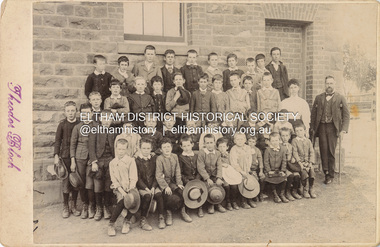 Eltham District Historical Society Inc
Photograph, Theodor Black, Boy students, Eltham State School No. 209, c.1904
Photo taken at the east end of the school. 1. Head Teacher John Brown served as HT from 1889 to his death in Sept 1906. 2. 53 Girls and 42 boys - 95 - attendance figures known between 1899 and 1906. 3. Female teacher in both photohraphs is Miss Amy E Barrowclough (Oct 1900 through 1904) [150th anniversary book incorrectly identifies her as Ellen Sweeney] 4. Youth in doorway is the Monitor, Harold Gilsenan (1904) 5. Post and rail fencing along Dalton Street (seen behind John Brown) was built in the upgrade of 1903 These facts date the photographs to be c.1904-c.1905 [Harry Gilham] Ina Falkiner is top row 4th from left Gertrude Falkiner is bottom row seated 4th from left. (Identified by Gertrude's garnddaugher and Ina's great neice, Judith Vun, email 26 May 2022) John Brown died 23 Sept 1906 after a short severe illness at age 55 and is buried in Box Hill Cemetery (Evelyn Observer 28 Sep 1906 p2). The book "We did open a school in Little Eltham" incorrectly states his date of death as 16/12/1906. Title The Evelyn Observer. (1906, September 28). Evelyn Observer and Bourke East Record (Vic. : 1902 - 1917), p. 2 (MORNING.) Url http://nla.gov.au/nla.news-article61129880 Description It is with sincere regret we record the death of Mr. John Brown, State school teacher, Eltham, which sad event took place at his residence, "Pine Brae," on Sunday night last, 23rd inst. after a severe illness of some few weeks' duration. The deceased gentleman was highly respected, and always took a lively and active interest in promoting the progress and prosperity of the district, and his loss will be much felt, He was only 55 years of age, and leaves a wife and large family to mourn their loss, and much sympathy is felt for them. The remains of the deceased were interred in the Box Hill cemetery on Wednesday afternoon last. PANEL 1875-1920 Panels began to be produced around 1875, and were particularly suited, because of their larger size, for capturing family, or even larger, groups. They measured 8.5 by 6.5 inches (22 cm x 16.5 cm). - Frost, Lenore; Dating Family Photos 1850-1920; Valiant Press Pty. Ltd., Berwick, Victoria 1991marg ball collection, shillinglaw family photo album 3, class photo, eltham primary school, eltham state school no. 209, 1904, harold gilsenan, john brown, miss amy e barrowclough, state school no. 209, theodor black photographer -
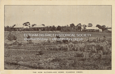 Eltham District Historical Society Inc
Photograph - Postcard, New Sutherland Home, 28 Drummond Street, Diamond Creek, c.1912
Postcard: Leader (Melbourne, Vic. : 1862 - 1918, 1935), Saturday 15 June 1912, page 48 ________________________________________ NEW SUTHERLAND HOME. OPENED BY THE PREMIER. A new home for destitute and neglected children, erected for the purpose of carrying on the work of the late Miss Sutherland, was formally opened by the Premier (Mr. Watt) at 28 Drummond-street on Thursday. The new building has been erected at a cost of £1600, of which only £300 has been provided by the Government. A similar sum has been raised by private contribution, but there is still a debt of £800 or £900, which the committee hopes to liquidate shortly - to some extent by means of a sale of gifts, which was 'opened in the building, and will be continued this afternoon and evening. The Premier, in performing the opening ceremony, said the home was a monument to the life work of one of the most distinguished social servants this country had known. (Applause.) Although Miss Sutherland was dead her good work lived on. It was too often true, as Shakespeare said, that "the evil that men do lives after them - the good is oft interred, with their bones." But the statement was contradicted by this noble building, erected for the commemoration of the work Miss Sutherland had instituted. After referring to the good work done by Mrs. Alexander Smith in connection with the building, Mr. Watt said that Victoria owed to the ladies and gentlemen who associated themselves with asylums, refuges, orphanages and homes of this sort a deep and abiding debt of gratitude. (Applause.) With no coercion from the Legislature, or from anyone, these ladies and gentlemen, were endeavouring to organise and keep alive the services that surrounded these institutions. There was no form of organised charity with which he was acquainted that deserved better of the public than this one. (Hear, hear.) Their hospitals, it was true, relieved a vast amount of suffering and affliction, but there was a sacred duty resting on any civilised community to see that those who were forsaken by their natural parents or guardians should not be left absolutely to the mercy of circumstance. The new home, which is intended as a receiving, house for destitute children - prior to their departure for the home at Diamond Creek - has living accommodation for some 20 children, but when fully furnished will accommodate more. It is plainly, but neatly, fitted up, with an abundance of light and air, and of facilities for hot and cold water. Both outside and inside it is an acquisition to the charitable institutions of the city. NEW SUTHERLAND HOME. (1912, June 15). Leader (Melbourne, Vic. : 1862 - 1918, 1935), p. 48. Retrieved March 14, 2024, from http://nla.gov.au/nla.news-article198132028 See also Sutherland Homes for Children https://wikinorthia.net.au/sutherland-homes-for-children/ Nov 29, 2012 The building was replaced by a much larger building in 1929 See NNT_107tom fielding collection, diamond creek, drummond street, miss sutherland, new sutherland home, opening, sutherland home for children -
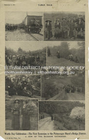 Eltham District Historical Society Inc
Magazine Article, J.E. Barnes, Wattle Day Celebration - The First Excursion to the Picturesque Hurst’s-Bridge District; A few of the blossom gatherers; Table Talk, September 5, p23, 1912
The September 5, 1912 issue of Table Talk celebrated "Wattle Day" where new plantings are made of the national flower and featured images from both Melbourne as well as the first excursion to Hurstbridge. Those from Hurstbridge were photographed by notable WW1 photographer, J.E. Barnes. Also digitised and accessible via National Library of Australia Trove website - (1912, September 5). Table Talk (Melbourne, Vic. : 1885 - 1939), p. 23. Retrieved July 28, 2024, from http://nla.gov.au/nla.news-page17413107 See an article on reflections about Wattle Day on page 29 - SOME REFLECTIONS UPON WATTLE DAY. (1912, September 5). Table Talk (Melbourne, Vic. : 1885 - 1939), p. 29. Retrieved July 28, 2024, from http://nla.gov.au/nla.news-article146180986 The inaugural Hurstbridge Wattle Day Festival was held Saturday, September 1, 1912 when a specially commissioned train brought 1,000 visitors to the district to enjoy the splendour of the wattle in bloom. “Melbourne’s first “Wattle Day” Campaign, the day when Australia’s national flower was to be all pervading in the streets of the metropolis, and sold in sprigs and bunches by hundred of lady volunteers, for purposes of charity, was not blessed with happy climatic conditions on Monday [2 Sep 1912]” - WATTLE DAY. (1912, September 7). Leader (Melbourne, Vic. : 1862 - 1918, 1935), p. 39. Retrieved July 28, 2024, from http://nla.gov.au/nla.news-article198116738 “In connection with Wattle Day celebrations a special train conveyed a thousand people to Hurst's-Bridge last Saturday afternoon [1 Sep 1912]. Lengthy reports of the excursion appeared in the daily papers last Monday. - WATTLE DAY. (1912, September 6). Evelyn Observer and Bourke East Record (Vic. : 1902 - 1917), p. 2 (MORNING.). Retrieved July 28, 2024, from http://nla.gov.au/nla.news-article60656027 See a review of the excursion to Hurst’s-Bridge - HURST'S-BRIDGE EXCURSION. (1912, September 2). The Age (Melbourne, Vic. : 1854 - 1954), p. 9. Retrieved July 28, 2024, from http://nla.gov.au/nla.news-article196255907 The excursion to Hurst’s-Bridge was considered such a success that the Railway department arranged to run another special train to the station on Saturday, October 5, 1912 - HURST'S-BRIDGE EXCURSION. (1912, October 2). The Age (Melbourne, Vic. : 1854 - 1954), p. 10. Retrieved July 28, 2024, from http://nla.gov.au/nla.news-article203325447Inaugural Hurstbridge Wattle Day Festival held 1 September 1912d3-class steam locomotive, hurstbridge wattle festival, special train, tait train, tourism, wattle day campaign, wattle day festival, david smyth collection -
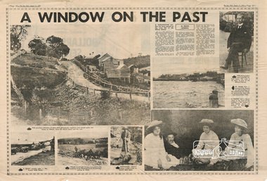 Eltham District Historical Society Inc
Newspaper - Newsclipping, Roger Sanders, A WINDOW ON THE PAST, 11 Aug 1976
Published in "The Sun", Wednesday, August 11, 1976, pp 38-39 [Text of article:] A WINDOW ON THE PAST by Roger Sanders. A fascinating window has been opened on the early life of the Eltham district. It is a rare collection of 3,000 perfectly preserved glass plate photograph negatives. The collection is the work of the late Albert Jones, a Diamond Creek orchardist and amateur photographer. About 500 of the negatives have been printed and 100 are on display at Gallery 4, Eltham, as part of the Eltham Festival, which started on Friday. They capture in fine detail rural and village life around Eltham, Hurstbridge, Kangaroo Ground, Yarra Glen and Diamond Valley from 1900 to 1930. While the natural beauty of the district was painted in this period by Arthur Streeton (later Sir Arthur), Tom Roberts and Charles Conder, among others, photography was relatively new. Yet Albert Jones used the new medium to compile a weighty album of pioneers at work, at home, at sport and on holidays. He was at the first Yarra Glen race meeting, early Diamond Valley football matches and photographed soldiers from the district leaving for war. He photographed early gold mines, men with horses laying the Diamond Creek-Hurstbridge rail track and the arrival of the first steam train at Hurstbridge. He took his cameras on holiday around Victoria and the collection includes scenes from St. Kilda and Portsea and many country towns. The Jones collection of negatives was found by Mr A. J. "Ned" Spark, of Balwyn, under a house he bought from Mr Jones' widow. The plates almost went to the tip with a pile of rubbish before Mr Spark realised their potential value. Mr Spark, who is retired, will continue the identification and recording of the photographs when he returns from holidays. The exhibition of the Jones' photographs is open each afternoon until August 21 at Gallery 4, 1016 Main Rd., Eltham. [Captions of photographs included in article:] • The priceless collection of glass plate negatives were found under this house in Eltham [actually Wattle Glen], home of Albert Jones and his wife. • A quiet country pub - Panton Hills Hotel. • Teams of draught horses were used in the building of the Diamond Creek-Hurstbridge railway in 1910. • Chinaman Jimmy using a gold cradle in Wattle Glen Gully. • The photographer and orchardist Albert Jones. His work is on show as part of the Eltham Festival • St Kilda Pier – several of the houses are still standing, but the waterfront has changed dramatically since this was taken before 1920. • A picnic was a dressy affair at the start of the century – the women in this family group are decked in lace and pearls.Newspaper articlealbert jones, golden glen, wattle glen -
 Kew Historical Society Inc
Photograph, Marnie McLeod, Floods of the River Yarra at Kew, 1916
The donation was accompanied by the following letter from the donor: "Hi. I found these in with family photos. Taken by family as Mamie McLeod was living in Fellows Street, Kew, so would be near there. Retain (or discard) as you see fit." [Donor's name and address withheld from public view]. To gain an insight into the flood levels at Kew, it is worth reading newspaper accounts of the event. The Age published an article - Valuable Gardens Destroyed at Kew - on 25 September 1916: "VALUABLE GARDENS DESTROYED AT KEW. From the heights of Studley Park, Kew, a splendid view of the flood waters can be obtained, and yesterday afternoon, despite continuous rain, crowds of citizens assembled there to witness the spectacle. There is a vast stretch of water some 300 or 400 yards broad, above the foot bridge connecting Gipps-street, Collingwood, and Studley Park. The river is only about 3 feet from the top of the embankment connecting with the ramp of the bridge on the Studiey Park side. When the upper llood waters come down it is almost a certainty that tne embankment will be submerged and the bridge rendered impassible. Below the bridge the waters again stretch out, and have submerged all the low-lying land on the Collingwood side and invaded the back premises ot the Kodak Co., Phoenix Biscuit Factory, a tannery adjoining thereto, the Shamrock Brewery, and Chinese gardens in the vicinity. At Walmer-street-bridge, at the end of Studley Park, the low-lying land on the Kew side is covered with water to the depth of many feet. Tlie land in question is owned in a great part by Mr Frank Lavers who haa gone in for intense culture on a pretty liberal scale on both the slopes of the hill and on the river flat. On the latter he is cultivating many acres of asparagus, and has at a considerable cost spent three years in preparing the ground and installing an irrigation system, reticulated from the Yan Yean water supply. This year the asparagus was put down, and the plants were in a promising condition. Tlie flood waters are now flowing fast over the land. The crop is ruined, and three years' work and expenditure destroyed. Mr. Laver's private residence fortunately is high above flood level, but two houses he owns off Young-street have been flooded out. Having been warned in time, the tenants removed their furniture hefore the water came down to Mr. Laver's residence, where they themselves have been given accommodation in the meantime. All the river flats in East Kew are under water. One or two low-lying houses have been flooded. Chipperfield's boat shed at Willsmere is nearly covered, and some Chinese gardens in the vicinity are several feet under water."This, and the other three photographs donated of floods in Kew are believed to be the earliest in the collection. Together with our original MMBW River Yarra map showing flood levels, these items, when compared allow researchers to gain a visual perspective of the extent of the flood in 1916. Black and white photograph of flooded trees in Kew with rising dry ground in distance.Inscription on reverse in pencil: "Flood River Yarra Kew Vic"river yarra, kew, floods 1916 -
 Kew Historical Society Inc
Photograph, Marnie McLeod, Floods on the River Yarra at Kew, 1916
The donation was accompanied by the following letter from the donor: "Hi. I found these in with family photos. Taken by family as Mamie McLeod was living in Fellows Street, Kew, so would be near there. Retain (or discard) as you see fit." [Donor's name and address withheld from public view]. To gain an insight into the flood levels at Kew, it is worth reading newspaper accounts of the event. The Age published an article - Valuable Gardens Destroyed at Kew - on 25 September 1916: "VALUABLE GARDENS DESTROYED AT KEW. From the heights of Studley Park, Kew, a splendid view of the flood waters can be obtained, and yesterday afternoon, despite continuous rain, crowds of citizens assembled there to witness the spectacle. There is a vast stretch of water some 300 or 400 yards broad, above the foot bridge connecting Gipps-street, Collingwood, and Studley Park. The river is only about 3 feet from the top of the embankment connecting with the ramp of the bridge on the Studiey Park side. When the upper llood waters come down it is almost a certainty that tne embankment will be submerged and the bridge rendered impassible. Below the bridge the waters again stretch out, and have submerged all the low-lying land on the Collingwood side and invaded the back premises ot the Kodak Co., Phoenix Biscuit Factory, a tannery adjoining thereto, the Shamrock Brewery, and Chinese gardens in the vicinity. At Walmer-street-bridge, at the end of Studley Park, the low-lying land on the Kew side is covered with water to the depth of many feet. Tlie land in question is owned in a great part by Mr Frank Lavers who haa gone in for intense culture on a pretty liberal scale on both the slopes of the hill and on the river flat. On the latter he is cultivating many acres of asparagus, and has at a considerable cost spent three years in preparing the ground and installing an irrigation system, reticulated from the Yan Yean water supply. This year the asparagus was put down, and the plants were in a promising condition. Tlie flood waters are now flowing fast over the land. The crop is ruined, and three years' work and expenditure destroyed. Mr. Laver's private residence fortunately is high above flood level, but two houses he owns off Young-street have been flooded out. Having been warned in time, the tenants removed their furniture hefore the water came down to Mr. Laver's residence, where they themselves have been given accommodation in the meantime. All the river flats in East Kew are under water. One or two low-lying houses have been flooded. Chipperfield's boat shed at Willsmere is nearly covered, and some Chinese gardens in the vicinity are several feet under water."This, and the other three photographs donated of floods in Kew are believed to be the earliest in the collection. Together with our original MMBW River Yarra map showing flood levels, these items, when compared allow researchers to gain a visual perspective of the extent of the flood in 1916. Panoramic view, believed to be looking north towards Fairfield from the Zig-Zag Bridge on the River Yarra. The inscription on the reverese identifies it as taken before 1920.Inscription on reverse in ink "(pre 1920) Flood from Zig-zag bridge Yarra River, Kew Vic."river yarra, kew, floods 1916, zig-zag bridge -
 Kew Historical Society Inc
Photograph, Marnie McLeod, Flood, River Yarra, Kew, 1916
The donation was accompanied by the following letter from the donor: "Hi. I found these in with family photos. Taken by family as Mamie McLeod was living in Fellows Street, Kew, so would be near there. Retain (or discard) as you see fit." [Donor's name and address withheld from public view]. To gain an insight into the flood levels at Kew, it is worth reading newspaper accounts of the event. The Age published an article - Valuable Gardens Destroyed at Kew - on 25 September 1916: "VALUABLE GARDENS DESTROYED AT KEW. From the heights of Studley Park, Kew, a splendid view of the flood waters can be obtained, and yesterday afternoon, despite continuous rain, crowds of citizens assembled there to witness the spectacle. There is a vast stretch of water some 300 or 400 yards broad, above the foot bridge connecting Gipps-street, Collingwood, and Studley Park. The river is only about 3 feet from the top of the embankment connecting with the ramp of the bridge on the Studiey Park side. When the upper llood waters come down it is almost a certainty that tne embankment will be submerged and the bridge rendered impassible. Below the bridge the waters again stretch out, and have submerged all the low-lying land on the Collingwood side and invaded the back premises ot the Kodak Co., Phoenix Biscuit Factory, a tannery adjoining thereto, the Shamrock Brewery, and Chinese gardens in the vicinity. At Walmer-street-bridge, at the end of Studley Park, the low-lying land on the Kew side is covered with water to the depth of many feet. Tlie land in question is owned in a great part by Mr Frank Lavers who haa gone in for intense culture on a pretty liberal scale on both the slopes of the hill and on the river flat. On the latter he is cultivating many acres of asparagus, and has at a considerable cost spent three years in preparing the ground and installing an irrigation system, reticulated from the Yan Yean water supply. This year the asparagus was put down, and the plants were in a promising condition. Tlie flood waters are now flowing fast over the land. The crop is ruined, and three years' work and expenditure destroyed. Mr. Laver's private residence fortunately is high above flood level, but two houses he owns off Young-street have been flooded out. Having been warned in time, the tenants removed their furniture hefore the water came down to Mr. Laver's residence, where they themselves have been given accommodation in the meantime. All the river flats in East Kew are under water. One or two low-lying houses have been flooded. Chipperfield's boat shed at Willsmere is nearly covered, and some Chinese gardens in the vicinity are several feet under water."This, and the other three photographs donated of floods in Kew are believed to be the earliest in the collection. Together with our original MMBW River Yarra map showing flood levels, these items, when compared allow researchers to gain a visual perspective of the extent of the flood in 1916. Small black and white photograph of flooded trees in Kew.Inscription on reverse in ink "Flood R. Yarra Kew Vicriver yarra, kew, floods 1916 -
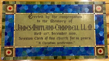 Kew Historical Society Inc
Plaque, Kew Presbyterian Church, James Maitland Campbell LL.M, 1931
Extracts from The Church on the Hill: Presbyterianism in Kew 1874-1974 by John A. O’Neill (Mullaya, Canterbury (Vic), 1974, pp.58-60. “An outstanding family which gave devoted service to the Church was the Campbell family of which James Maitland was the “head”. He died at “Ramornie” on the afternoon of Monday 15 December 1930. … “James Maitland Campbell was born in 1847 in Melrose, Scotland, where his father, the Rev. A. J. Campbell D.D., was the Minister of the Kirk. The Rev. Dr. and Mrs. A. J. Campbell, with their family, came to Australia in 1861 and settled in St. George’s Church, Geelong, where he was the first Minister. James Maitland, after completing his secondary education at Geelong College, entered the Melbourne University where he graduated Master of Arts and Master of Laws, and eventually became a partner in the legal firm of Davies and Campbell. When he first came to Melbourne Mr Campbell attended Chalmers Church, East Melbourne, and married Miss Annie Harper, daughter of Robert Harper, a merchant and a sister of Professor Andrew Harper. In March 1875 the young couple settled in Pakington Street, Kew. After the induction of the Rev. Maxwell and the formation of a Board of Management, Mr. Campbell was elected its first Secretary. David Beath, James Maitland Campbell and Duncan Robert McGregor were the first Trustees of our Church. Mr. and Mrs. Campbell joined the Church Choir, and Mr. Campbell became Choir Leader. Members of their family, Bessie, Mary, Nellie and Lewis also sang in the Choir. Mary became a famed teacher of singing in Melbourne. She taught singing to members of the Choir, and gave lessons in voice production to students for the Ministry. In 1879 Mr. Campbell became Superintendent of the Sabbath School, a position he occupied for 27 years. In 1887 he was elected an Elder, and the Session Clerk for 37 years. In 1924 Mr. Campbell compiled a very complete Jubilee History of the Kew Presbyterian Church. Mr. J. M. Campbell saw our existing Church and the Old Manse erected, the Villa purchased, and, with the help of the Kew Congregation, the Charges of West Hawthorn, East Kew and Deepdene established. In the General Assembly of Australia and the General Assembly of Victoria he occupied the important position of Law Agent, and was a member of numerous Church Committees and Councils. … At the Annual Congregational Meeting on Wednesday 28 October 1931, it was decided to erect a tablet in the Church to the memory of the late Mr. J. M. Campbell to record his service to the Church. The tablet was unveiled at the morning service on 13 December by Mr. Legge. The Preacher was Rev. J. Barnaby.”James Maitland Campbell (1847-1930) the owner of “Ramornie” in Pakington Street was an important contributor to the community of Kew in the 19th and early 20th centuries. A Councillor of the Borough of Kew, he was to be elected Mayor on three occasions: 1889-90, 1890-91 and 1892-93. In addition to his political roles, he was the first Secretary of the Kew Presbyterian Church, being actively involved in the life of the Church until his death in 1930. The Kew Historical Society has a small collection of items once belonging to the Campbell family, including a series of invitations issued to Mr. and Mrs. J. M. Campbell for the festivities organised to commemorate the opening of the first Australian Parliament in Melbourne in 1901. Memorial Tablet to James Maitland Campbell (1847-1930) that was originally erected in the Kew Presbyterian Church in Cotham Road. The tablet is comprised of iridescent ceramic tiles.“Erected by the congregation to the Memory of James Maitland Campbell. LL.M. died 15th., December 1930. Session Clerk of this church for 36 years. “A Christian gentleman.”james maitland campbell (1847-1930), kew presbyterian church, ramornie (pakington street), campbell collection -
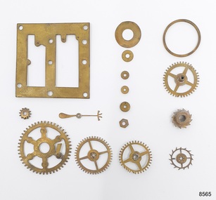 Flagstaff Hill Maritime Museum and Village
Instrument - Clock Parts, Bef. 01-06-1878
The clock parts were discovered in 1980 by Julie Wilkins, a Victorian scuba diver who had already experienced more than 500 dives in Australia and overseas. She was holidaying in Peterborough, Victoria, and looking forward to discovering more about the famous Loch Ard ship, wrecked in June 1878 at Mutton Bird Island. The fast Glasgow-built clipper ship was only five years old when the tragedy occurred. There were 54 people on board the vessel and only two survived Julie's holiday photograph of Boat Bay reminds her of her most memorable dive. Submerged in the calm, flat sea, she was carefully scanning around the remains of the old wreck when, to her amazement, a gold coin and a small gold cross suddenly came up towards her. She excitedly cupped them in her hands and then stowed the treasures safely in her wetsuit and continued her dive. She soon discovered a group of brass carriage clock parts and some bottles of champagne. It was a day full of surprises. The items were easily recognisable, without any build-up of encrustations or concretion. Julie secretly enjoyed her treasures for twenty-four years then packed them up for the early morning train trip to Warrnambool. After a short walk to Flagstaff Hill Maritime Museum and Village, her photograph was taken as she handed over her precious find. She told her story to a local newspaper reporter, lunched a café in town then took the late afternoon train home. Her generous donation is now part of a vast collection of Loch Ard shipwreck artefacts, including the gold watch and the Minton Majolica model peacock. This group of brass clockwork parts is incomplete. The pieces were in the ocean for over 100 years before Julie recovered them from the Loch Ard wreck. Their size would suit the works of a carriage clock, with a mainspring and weight to power the clock movement, a pendulum to measure the clock's speed, arbours, posts, pillars and at least one other plate. They would have been mounted inside a protective case with a small door to easily access the clock face for setting the time and accessing the key's winding hole. The clock cases were usually made from decorative gilt brass with a glass front and a carrying handle. The parts include a weighted second hand with a decorative four-pronged finish at one end, a rounded weight at the other, and a hole for attaching it to the clock face. The gear teeth profiles are ‘cycloidal’, an arch shape with vertical sides, which is common for antique clocks. Modern clockworks have ‘involute’ teeth with sloping sides and a squared-off top. The brass carriage clock parts are an example of a mechanical clock produced in the 1870s. The clock's design is a part of the chain of technological improvements in methods for timekeeping. Its cycloidal gear teeth were the forerunner of the more modern involute gears. The group of clock parts includes a weighted hand or arm for signifying the seconds. This feature was uncommon in portable Victorian-era clocks. The clock parts are also significant for their association with the ill-fated sailing ship Loch Ard, wrecked in 1878. The travelling clock or officer’s clock may have been part of the cargo destined for the 1880 Melbourne Exhibition, or the personal possession of one of the people on board the vessel. Brass clockwork parts from a mechanical clock, sixteen pieces. Parts comprise a plate, large gears or wheels, small pinions or wheels with fine teeth, wheels with cogs, and a weighted second hand. The parts were from a carriage clock ca. 1878. They were recovered from the wreck of the sailing ship Loch Ard.flagstaff hill maritime museum and village, warrnambool, great ocean road, shipwreck coast, loch ard, wreck of the loch ard, 1878, mutton bird island, peterborough, scuba diver, 1980s, shipwreck artefact, relic, clock, mechanical, clock parts, time, timekeeper, horology, chronometry, cogs, time keeping device, scientific instrument, chronometer, john harrison, longitude, carriage clock, coach clock, portable clock, travelling clock, travel clock, traveller’s clock, officer’s clock, weighted second hand, victorian era, cycloidal gear teeth, brass clock, julie wilkins -
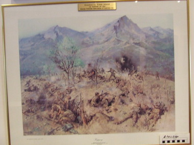 Waverley RSL Sub Branch
Print Kapyong, Kapyong
On 23 April, the 3rd Battalion, Royal Australian Regiment (3 RAR), under the command of Lieutenant Colonel Bruce Ferguson, and the 2nd Battalion, Princess Patricia's Canadian Light Infantry, occupied prominent hills on either side of the seven-kilometre-wide valley, where a small tributary joined the Kapyong River. Also forward were headquarters units, tanks and artillery. The 1st Battalion, Middlesex Regiment, were to the rear. Early in the evening, retreating South Koreans streamed past the Commonwealth position, with Chinese forces closely intermingled. Soon afterwards a platoon of American tanks supporting 3 RAR was overrun. The Kapyong valley was too large an area to defend with the forces available, and the brigade was spread very thinly. Throughout the night the Chinese repeatedly pressed the Australian positions, attacking in waves over their own dead and wounded. At dawn, A Company, under the command of Major Bernard "Ben" O'Dowd, found that the Chinese had infiltrated its position, but a counter-attack was able to eject them. Meanwhile B Company, which had spent the night on a hill near the riiver, discovered Chinese occupying some old bunkers on a small knoll. Hand-to-hand fighting ensued with grenades and bayonets. C Company, under the command of Captain Reg Saunders, was in position to reinforce both A and B Companies. "Major O'Dowd then directed the radio operator to contact anyone. The American 1st Marine Division answered but their operator refused to believe who our operator was speaking for. Major O'Dowd took the phone and demanded to speak to the commanding officer. The general in charge of the [Marine] division came on the phone and told O'Dowd we didn't exist as we had been wiped out the night before. Major O'Dowd said, 'I've got news for you, we are still here and we are staying here.'" Private Patrick Knowles, 3 RAR, on the morning of 24 April 1951 Fighting continued throughout the day with the Australians holding their positions, and the Chinese also engaging D Company. But late on 24 April, with their position now untenable, the Australians were forced into a fighting withdrawal down a ridge to the valley, where they rejoined the brigade. Their withdrawal was supported by New Zealand artillery from the 16th Field Regiment. Having found the Canadian position unassailable, the Chinese made no further attacks. By the afternoon of 25 April the road through to the Canadians had been cleared of Chinese and 2 PPCLI was relieved by US Army units. On Anzac Day 1951, the Australians rested after a long fight. Thirty-two Australians were killed and 53 were wounded for their part in stalling the Chinese advance and preventing Seoul from falling into enemy hands. Lieutenant Colonel Bruce Ferguson was awarded the Distinguished Service Order for his skilful leadership, and the Australian and Canadian battalions both received United States Presidential Distinguished Unit Citations for their part in the battle. http://www.awm.gov.au/exhibitions/korea/operations/kapyong/Print of painting of action in Kapyong Korea in wooden frame under glassDonated by Frank Arnold on behalf of Korean Veterans Association of Australia inc.korea, kapyong, 3rar -
 Eltham District Historical Society Inc
Photograph, Shire of Eltham War Memorial, Memorial Park, Garden Hill, Kangaroo Ground; Eltham Heritage Tour, 24 May 1992, 24/05/1992
ELTHAM HERITAGE TOUR The Society excursion on 24th May 1992 was arranged by David Bick, leader of the team carrying out the Shire's heritage study. David selected a number of sites or buildings identified in the study, some of them lesser known components of the Shire's heritage. The tour commenced at the Eltham Shire Office at 10.00 am. Travel was by private car and mini-bus with stops at about twelve locations for commentary by David.It included a short walk in Hurstbridge and lunch at Kinglake. Highlights of the tour included: - 10 am Leave from Shire Offices - 3 Important Trees - A Physical Link to Eltham's First Settlers - Toorak Mansion Gates - A Surviving Farm House - An Intact Circa 1900 Main Street - First Settlers - Gold Miners, and Timber-getters - An Early Hotel - A Pioneering Homestead - Changing Eltham Shire - 20th Century - 4 pm Afternoon Tea and Finish Tour Extract from ELTHAM CULTURAL HERITAGE TOUR (Newsletter No. 85, July 1992, by Bettina Woodburn) "Now we drove through stands of pines to the Kangaroo Ground Lookout Tower, a most unusual War Memorial, World War I. The tower and a shed/residence (it had a chimney) were built from local sandstone. Below to the south and east of Melbourne spread 'suburbia'. Close by the landscape seemed so contrived - English fields and hedgerows! Although only about twenty inches deep, the soil of this ancient volcano, its crater lost under subsequent weathering, was rich, deserving the name of "Garden Hill". Now native trees are taking over again. In Kangaroo Ground itself stand the inevitable Store, School and Church - and two Norfolk pines and a monkey puzzle tree." On November 11th 1926 the Shire of Eltham War Memorial Tower at Kangaroo Ground was opened. It is regarded as one of Melbourne’s most outstanding lookout towers. It commands a magnificent 360 degree panorama from Kinglake across the Diamond Valley to Macedon and the You Yangs. It is built on a peak which was once a volcano, 237 metres above sea level. After World War one a memorial cairn was erected on the site, and in 1925 a committee of public-minded citizens began to plan for a tower. Many generous donations of material and money were forthcoming so that in 1926 the Governor General Lord Stonehaven was able to unveil the plaque before a crowd of 500 people. There was some concern in the 1960s when the Forests Commission wanted to build a firespotters cabin on the top. At first R.S.L. branches opposed the idea, but it was realised that this use could combine with its use as a tourist attraction, and would ensure its maintenance for the future, Today the Kangaroo Ground tower provides one of the best views around Melbourne and is a fitting memorial to those who died in two world wars. From: Historic items for Diamond Valley Community Radio September 1990 (EDHS collection) Record of the Society's history and activities and highlighting various aspects of the Heritage Study undertaken by David Bick used to create the future heritage overlay for the Shire of Eltham and later Nillumbik Shire.Roll of 35mm colour negative film, 4 stripsKodak Gold 100 5095culture, events, garden hill, kangaroo ground, kangaroo ground memorial, memorial park, shire of eltham war memorial tower, war memorials -
 Eltham District Historical Society Inc
Photograph, Murchison Gap, Autumn Excursion, Hume and Hovell's 1824 expedition, 26 May 1996, 26/05/1996
[article by Bettina Woodburn in EDHS Newsletter No. 109, July 1996:] ON THE TRAIL OF HUME AND HOVELL - REPORT ON THE AUTUMN EXCURSION - On a green and fresh morning (Sunday 26th May 1996) the Cobb and Co coach (driven by the most obliging Peter Tampion) set off in a north easterly direction from Eltham to connect with Hume and Hovell's route on their 1824 explorations of central Victoria. The Society would follow a series of monuments erected for the 1924 centenary of the expedition from King Parrot Creek (Tuesday 7th December 1824), through Strath Creek, over Sunday Creek (Sunday 12th December 1824) at Broadford, Tullamarine, St Albans, Deer Park, through Werribee, skirting east of the You Yangs to Lara and Avalon Beach. Because their distance-measuring wheel had broken and a one degree mistake was made in calculations, the two leaders of the original group of six convict-companions arrived at Corio Bay, instead of the expected Western Port, discovered earlier by Flinders. From below Mt. Disappointment (Hume and Hovell's difficulties in "scrambling over brush and rock", "leeches in forest, as well as no water", "cutting grass 4-5 ft. high", dreadful scrub", "devil flies") we took an easier route, saw the Strath Creek memorial in ground fog and a wonderful "field of dreams", the Hume-Hovell privately owned cricket ground with its white picket boundary fence. Now, after a steep climb, in sunshine under gums we stretched and viewed magnificent rolling hills and fog-filled valleys - not "smoke from Aborigines' bush fires". After morning tea at Broadford we followed the Sunday Creek valley beside the Hume Freeway, passed the Wallan Wallan Rest Area (more appropriately Hume and Hovell Rest Area) to tum right at Beveridge. In Gellibrand Hill Park, near the headwaters of the Moonee Ponds Creek, we experienced the landscape the first European settlers saw - huge river red gums and rolling pastures. The gardens and sheltered courtyard of the 1840s, timber, brought from .....[?] prefabricated Woodlands Homestead, provided a pleasant lunch stop. We enjoyed a private tour, panoramic views over Melbourne and surroundings and the excitement of arriving and departing aircraft. Our next river crossing was at Werribee, "in a vast treeless plain", then we drove on by-ways no coach had previously travelled, to find "an immense sheet of water" salty Corio Bay, off-course to the west. In late afternoon of a super, calm, late autumn day we headed homewards. Back at Eltham we were rather surprised to find that we had travelled a total of 347 km. Thanks again to Russell Yeoman for his research and organization. What a wonderful day! Three colour photographsactivities, murchison gap, murchison valley -
 Eltham District Historical Society Inc
Photograph, Hume and Hovell Monument, Broadford, Autumn Excursion, Hume and Hovell's 1824 expedition, 26 May 1996, 26/05/1996
[article by Bettina Woodburn in EDHS Newsletter No. 109, July 1996:] ON THE TRAIL OF HUME AND HOVELL - REPORT ON THE AUTUMN EXCURSION - On a green and fresh morning (Sunday 26th May 1996) the Cobb and Co coach (driven by the most obliging Peter Tampion) set off in a north easterly direction from Eltham to connect with Hume and Hovell's route on their 1824 explorations of central Victoria. The Society would follow a series of monuments erected for the 1924 centenary of the expedition from King Parrot Creek (Tuesday 7th December 1824), through Strath Creek, over Sunday Creek (Sunday 12th December 1824) at Broadford, Tullamarine, St Albans, Deer Park, through Werribee, skirting east of the You Yangs to Lara and Avalon Beach. Because their distance-measuring wheel had broken and a one degree mistake was made in calculations, the two leaders of the original group of six convict-companions arrived at Corio Bay, instead of the expected Western Port, discovered earlier by Flinders. From below Mt. Disappointment (Hume and Hovell's difficulties in "scrambling over brush and rock", "leeches in forest, as well as no water", "cutting grass 4-5 ft. high", dreadful scrub", "devil flies") we took an easier route, saw the Strath Creek memorial in ground fog and a wonderful "field of dreams", the Hume-Hovell privately owned cricket ground with its white picket boundary fence. Now, after a steep climb, in sunshine under gums we stretched and viewed magnificent rolling hills and fog-filled valleys - not "smoke from Aborigines' bush fires". After morning tea at Broadford we followed the Sunday Creek valley beside the Hume Freeway, passed the Wallan Wallan Rest Area (more appropriately Hume and Hovell Rest Area) to tum right at Beveridge. In Gellibrand Hill Park, near the headwaters of the Moonee Ponds Creek, we experienced the landscape the first European settlers saw - huge river red gums and rolling pastures. The gardens and sheltered courtyard of the 1840s, timber, brought from .....[?] prefabricated Woodlands Homestead, provided a pleasant lunch stop. We enjoyed a private tour, panoramic views over Melbourne and surroundings and the excitement of arriving and departing aircraft. Our next river crossing was at Werribee, "in a vast treeless plain", then we drove on by-ways no coach had previously travelled, to find "an immense sheet of water" salty Corio Bay, off-course to the west. In late afternoon of a super, calm, late autumn day we headed homewards. Back at Eltham we were rather surprised to find that we had travelled a total of 347 km. Thanks again to Russell Yeoman for his research and organization. What a wonderful day! Colour photographactivities, broadford, hume and hovell, monument -
 Eltham District Historical Society Inc
Photograph, Hume and Hovell Monument, Autumn Excursion, Hume and Hovell's 1824 expedition, 26 May 1996, 26/05/1996
[article by Bettina Woodburn in EDHS Newsletter No. 109, July 1996:] ON THE TRAIL OF HUME AND HOVELL - REPORT ON THE AUTUMN EXCURSION - On a green and fresh morning (Sunday 26th May 1996) the Cobb and Co coach (driven by the most obliging Peter Tampion) set off in a north easterly direction from Eltham to connect with Hume and Hovell's route on their 1824 explorations of central Victoria. The Society would follow a series of monuments erected for the 1924 centenary of the expedition from King Parrot Creek (Tuesday 7th December 1824), through Strath Creek, over Sunday Creek (Sunday 12th December 1824) at Broadford, Tullamarine, St Albans, Deer Park, through Werribee, skirting east of the You Yangs to Lara and Avalon Beach. Because their distance-measuring wheel had broken and a one degree mistake was made in calculations, the two leaders of the original group of six convict-companions arrived at Corio Bay, instead of the expected Western Port, discovered earlier by Flinders. From below Mt. Disappointment (Hume and Hovell's difficulties in "scrambling over brush and rock", "leeches in forest, as well as no water", "cutting grass 4-5 ft. high", dreadful scrub", "devil flies") we took an easier route, saw the Strath Creek memorial in ground fog and a wonderful "field of dreams", the Hume-Hovell privately owned cricket ground with its white picket boundary fence. Now, after a steep climb, in sunshine under gums we stretched and viewed magnificent rolling hills and fog-filled valleys - not "smoke from Aborigines' bush fires". After morning tea at Broadford we followed the Sunday Creek valley beside the Hume Freeway, passed the Wallan Wallan Rest Area (more appropriately Hume and Hovell Rest Area) to tum right at Beveridge. In Gellibrand Hill Park, near the headwaters of the Moonee Ponds Creek, we experienced the landscape the first European settlers saw - huge river red gums and rolling pastures. The gardens and sheltered courtyard of the 1840s, timber, brought from .....[?] prefabricated Woodlands Homestead, provided a pleasant lunch stop. We enjoyed a private tour, panoramic views over Melbourne and surroundings and the excitement of arriving and departing aircraft. Our next river crossing was at Werribee, "in a vast treeless plain", then we drove on by-ways no coach had previously travelled, to find "an immense sheet of water" salty Corio Bay, off-course to the west. In late afternoon of a super, calm, late autumn day we headed homewards. Back at Eltham we were rather surprised to find that we had travelled a total of 347 km. Thanks again to Russell Yeoman for his research and organization. What a wonderful day! Two colour photographsactivities, hume and hovell, monument