Showing 742 items
matching arrival
-
 Eltham District Historical Society Inc
Photograph, Tom Prior, Police Station and Residence, Maria Street, Eltham, c.1900
Situated near the top of what was known as 'Policeman's Hill' according to Miss Ivy Reynolds, neice of the photographer, Tom Prior. From the left, Eltham Court House, Police Residence and Police station on Main Road and corner of Brougham Street. These buildings formed part of Little Eltham and still stand (without the front fence) today though the Police Station was demolished in 1986 due to termite damage. A replica was built circa 1989. The institutions of law and order in Colonial Victoria included the police, courts and prisons. The 1852 report of the Snodgrass Select Committee appointed to "identify the policing needs of the colony” noted there existed seven independent police forces that did not co-operate or regularly communicate. Following the committee's report all these police entities were merged into the Victoria Police, founded on 8 January 1853, to implement law and order responsibilities throughout the Colony of Victoria. The Eltham Courthouse (1860) and adjacent Police Residence (1859) formed a justice precinct established in the immediate aftermath of the 1852 police inquiry and the effects of the gold rush. The physical presence of these buildings, in the centre of the early Eltham township, defined centralised control over law and order. In the early days the Police Constable in charge would conduct his duties travelling around the district by horse; a stable was located at the rear of the residence. At times the horse would be grazed on the paddocks across the road. Horseshoes were forged by the blacksmith beside the Courthouse on the high side of “Policeman’s Hill”. Along with the stable, there was a two-cell bluestone lockup where prisoners were held awaiting trial in the adjacent Courthouse. Their meals were usually provided by the policeman’s wife or from the hotel just up the road. With the arrival of the railway in 1902 the town centre gradually shifted towards the railway station. The Police Station and operations were moved into the town centre in 1961 to a renovated house in Pryor Street, which was later replaced by the current Police Station. From 1961-1981 the residence was occupied by the Vermin and Noxious Weeds Destruction Section of the Department of Crown Lands and Survey. Prior to August 1967 the former Police Station was dragged to the rear of Police Residence to make way for the construction of a driveway and access from Main Road. The building was placed on the site of a former Scullery and modified for Lands Department use. In 1981 the Shire of Eltham took over management of the former Police Residence in Eltham. It remained unoccupied for a period whilst its future was discussed in Council. It was then used for a community job creation scheme until 1985. In 1985 the Shire of Eltham Parks and Environment occupied the residence. Council improved the driveway but later added a second rear access from Brougham Street due to the dangerous nature of the Main Road entrance. Additionally, a rear toilet facility between the Police Residence and the relocated former Police Station, which was doubling up as a lunchroom. Council also commenced discussions to re-establish a replica Police Station. Around November 1986 the former Police Station was demolished; believed to have been suffering termite damage. About 1989, after some years of discussion, a replica Police Station was built, based on photographs, to act as a lunchroom and meeting room for the Parks and Environment staff and volunteers doing community service. In 1996 Eltham District Historical Society held discussions with Nillumbik Shire Council commissioners throughout the year regarding a home for the Society. A proposal was put forward by the Society in October to occupy the former Police Residence. In March 1997 Eltham District Historical Society gained access to former Police Residence and on July 12, 1998, moved into its Local History Centre. In July 2018, Eltham District Historical Society gained access to the replica Police Station (which had been used as a music library and storage for the Eltham Concert Band) for use as part of regular heritage tours for schools and community-based groups.This photo forms part of a collection of photographs gathered by the Shire of Eltham for their centenary project book,"Pioneers and Painters: 100 years of the Shire of Eltham" by Alan Marshall (1971). The collection of over 500 images is held in partnership between Eltham District Historical Society and Yarra Plenty Regional Library (Eltham Library) and is now formally known as 'The Shire of Eltham Pioneers Photograph Collection.' It is significant in being the first community sourced collection representing the places and people of the Shire's first one hundred years. The Reynolds family were early settlers in Research. The Reynolds/ Prior collection of photographs were taken by Tom Prior, the maternal uncle of Ivy Reynolds, around 1900 and the 60 photos in the album give a fine overview of many of the landmarks of Research and Eltham over 100 years ago. lvy lived in the family home for many years at 106 Thompson Cres Research. Ivy's father, Ernst Richard Reynolds and grandfather, Richard Reynolds, lived at the same address. Ivy's father Richard worked for Mr. Trail on his property in Research. Reynolds Road is named after the family. Mr Tom Prior (wife Eva) worked at the Melbourne zoo. He was very innovative and made his own camera, using the black cloth hood to exclude the light. The photographs are a reminder of the rural nature of Research and Eltham and its rich heritage.Digital imagechildren, court house, courthouse, eltham, eltham district historical society, eltham justice precinct, little eltham, local history centre, main road, police residence, police station, reynolds prior collection, sepp, shadow, shire of eltham pioneers photograph collection -
 Glenelg Shire Council Cultural Collection
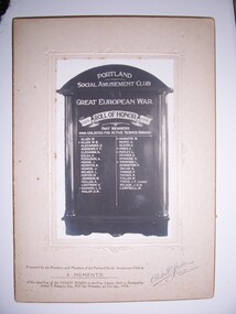
Photograph - Photograph - Portland Social Amusement Club, n.d
The Portland Social Amusement Club was founded in 1897. Taken from Trove. Portland Guardian Monday May 26 1913: Portland Social Amusement Club. The members of the above Club celebrated the 16th anniversary of its foundation on Tuesday evening last, when the usual banquet. and social gathering was held. During the afternoon, a numerous band of the lady members attended at the, Free Library Hall and made the necessary arrangements, so that on arrival at the scene at 8 p.m. those attending were very pleasurably surprised to find most taste fully decorated tables actually groaning with the weight of all those good things which appeal so strongly, it is said, to the average man, and perhaps we may also add, woman also. At any rate, he would indeed be hard to please, who was not fully satisfied with all that was placed before him on that eventful evening. The attendance this year overtopped that of previous years, as over 80 ladies and gentlemen took part in what must be considered as one of the most successful of the many 'successful gatherings that have taken place. This 16th anniversary was the 431st ordinary gathering that had occurred, and, as the President (Mr. F. A.Row) justly said, it would appear that the Club, which many years ago was given but six months live, had proved the falsity of the attempted prophecy. After the principal business of the gathering had been transacted, the usual Club dinner speeches were made. The President gave "The King," which after being duly honored, was followed by the principal toast of the evening, "The day we celebrate." To Mr D. McDonald the toast of the Absent and Foundation members was entrusted, and as usual, that veteran discharged his duty well. II i cferred to the fact that of the 34 foundation members who started the Club in 1897,only five were present that evening. Mr W. T. Bennett, as one of the five referred to, responded, and hoped that in the glorious future that appeared before Portland, the Club, which had been started in the days of its adversity, would flourish in a like manner. Mr Grant proposed the toast of "Our Visitors." and in the name of the Club welcomed them to this the most important gathering of the year. Mr J. R. Woods responded in his usual happy way, and acknowledged that, until he had been the Club's guest during the years of his mayoralty of the town, he had no idea that it had enrolled among its members the number of ladies and gentlemen that it had or that its functions were upon the scale that he had since found to be the case. Mr G. H. .ennett upheld the claims of the ladies, especially those belonging to the Club. He evidently spoke with much feeling, and. waxed more than usually poetical in his eulogy of the graces and skill of the gentler sex. He rather upset the equilibrium of three of the younger portion of the gentlemen present by asking them to respond, but they all managed to "upstand" and make their acknowledgments. Mr T. F. Cruse was particularly happy in proposing the toast of. "The President and Members of Committee," who, he claimed, had done so much towards the success of the Club, and were deserving of the best that the members could give. Mr T. E. C. Henry, upon the invitation of the .President, responded,-end pointed out that [whilst it might appear that the work of the committee was light, it was not so in reality, as any member who desired a seat upon the Board would soon find out after.his or her election. The singing of Auld Lang Syne brought this portion of the entertainment to a close. In the dance which followed, some opportunity to view the ladies' dresses was afforded, and it could then be easily seen that the anniversary gathering of the Club was considered by the lady members at least, if not .by others, to be important enough to demand special treatment in the matter of dress. Many elaborate and beautiful costumes graced the scene, and everyone appeared to thoroughly enjoy themselves. The function was kept going merrily until about 2 a.m.; when the break up occurred. During the gathering telegrams of con gratulation were received from Mr W. B. Shevill and also from Mr Jno. Homers, both old members, the former a foundation one. Mr O'Donnell apologised for his own and Mrs O'Donnell's absence.Photograph of Portland Social Amusement Club -
 Eltham District Historical Society Inc
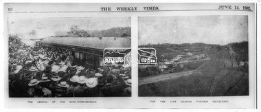
Photograph, The Weekly Times, Opening of the Heidelberg-Eltham Railway Line, 6 June 1902, 1902
Reproduced from "The Weekly Times", 14th June 1902, page 10. 06 Jun 1902 Cross Reference Photo No.(s): 602, 604 Source: La Trobe Library and National Library, Canberra THE HEIDELBERG TO ELTHAM RAILWAY. OPENING CEREMONY. The opening of the railway line from Heidelberg to Eltham took place on the 6th inst. The special train, containing a large number of members of Parliament, including Mr Trenwith, the Minister for Railways, left Prince's Bridge at half-past eleven, and arrived at Eltham at twenty minutes past twelve. The party was accompanied by Mr Fitzpatrick, Acting Commissioner for Railways; Mr Lockhead, the Traffic Manager; and Mr Norman, Engineer for Existing Lines. On arrival, the visitors were entertained at a banquet in the marquee, of which a photograph is given, erected close to the railway station. Mr E. H. Cameron, M.L.A., the member for the district, occupied the chair, and, seated on his right, was Mr Mason, the Speaker of the Legislative Assembly, and on his left the Minister of Rail-ways. After the banquet His Excellency the Governor-General arrived, and was received and welcomed by Mr Cameron, the local State school children singing the National Anthem. The Governor-General, in declaring the line open, said that he felt highly honored at being asked to perform the opening ceremony, and he trusted that the railway would be a source of great convenience to the inhabitants of the district. He was sorry to say that this would be the last opportunity he would have of seeing them. It cost him a great deal to leave them. (Hear, hear.) He had a great many friends amongst all sections of the community, and he could hardly bear to trust himself to speak about leaving them. (Hear, hear.) He was sorry Lady Hopetoun was on the high seas, and unable to accompany him that day. Mr Cameron thanked his Excellency for performing the opening ceremony, and hoped the trip home would have the effect of restoring His Excellency to good health again. In replying. Lord Hopetoun thanked them sincerely for the cordial vote of thanks. He hoped Providence would shower her blessings over them, and that they would have a series of good seasons. He would always keep a warm corner in his heart for the people of Victoria. (Loud cheers.) THE COUNTRY. In our illustrations, views are given of a couple of sections of the new line, and glimpses of the surrounding country are shown. The line is eight miles in length, and cost £51,000 in construction. Eltham, which is the terminus, possesses many of the features that go to make a favorite holiday resort. It is a quiet picturesque little hamlet, snugly ensconced on the slope of one of many sombre-tinted hills by which it is sur-rounded. Even when viewed under ad-verse conditions one could not fail to be-impressed with the natural, rugged beauty of the place. It is situated about sixteen miles from Melbourne, and the line takes a circuitous course through a continuation of pretty undulating country. At intervals on the slopes of the surrounding green-mantled hills, patches of brown, freshly tilled soil indicate that for all its serene reposeful-ness Eltham possesses its phases of industrial life as well. Looking down into this valley from the main road which skirts the slope of a hill, distant something less than a quarter of a mile from the railway station is one of the prettiest pieces of scenery in the district. Verdure-clad hills ascend on all sides, whilst beneath stretches a broad expanse of carpet-like green sward, dotted here and there with picturesque homesteads, each with its patches of tilled soil. In the township itself the dwelling-houses are comparatively few, the larger portion of the inhabitants residing in the scattered homesteads. Eltham is as yet only in its youth, but energetic and un-tiring public men can effect wonders in a community's prosperity, and Eltham, whatever other real or imaginary advantages it may lay claim to, certainly possesses this one. The railway is the result of their endeavor. 1902 'THE HEIDELBERG TO ELTHAM RAILWAY.', Weekly Times (Melbourne, Vic. : 1869 - 1954), 14 June, p. 14. , viewed 26 Sep 2018, http://nla.gov.au/nla.news-article221230719This photo forms part of a collection of photographs gathered by the Shire of Eltham for their centenary project book,"Pioneers and Painters: 100 years of the Shire of Eltham" by Alan Marshall (1971). The collection of over 500 images is held in partnership between Eltham District Historical Society and Yarra Plenty Regional Library (Eltham Library) and is now formally known as the 'The Shire of Eltham Pioneers Photograph Collection.' It is significant in being the first community sourced collection representing the places and people of the Shire's first one hundred years.Digital image 35mm B&W negativesepp, shire of eltham pioneers photograph collection, eltham, heidelberg-eltham railway extension -
 Melton City Libraries
Letter, Letter from Margaret B Gibson, 1928/2014
David McKenzie obituary, Romsey Examiner 1928 Another of Australia’s very old pioneers in the person of Mr McKenzie, passed away last weekend at his daughters residence At regent at the ripe old age of 92 years ( he would be 93 in November) Born at Berwick of Tweed Scotland, the late Mr McKenzie arrived in Australia with two of his uncles in 1855 by the ship “Red Jacket”. A stone- mason by trade he worked about Melbourne and at Geelong until attack by “gold fever” but met with no success at this venture so he returned to his trade, arriving at Melton about 1860. There he married and settles for about 20 years. In 1880 the Cherokee Heights with its subdivision was famous and Mr McKenzie moved there with his daughter. He continues in his trade, his work extending to Gisborne, Bacchus Marsh, Romsey, and Springfield and other places, where to this day, may be seen monuments of his skill and through tradesmanship as a mason. During his residence in the Mount, he took a keen interest in all the affairs of Kerrie and Cherokee, and he was a familiar figure at all the public gatherings at which he nearly always filled the position of Chairman, because of outstanding qualifications. He was a man of those sterling qualities possessed by those men who laid the foundation of this country so well and truly. Loyal, broad of vision, just in thought and deed, honourable to the extreme in all dealings, fearless in the cause of right, a lover of home and family, and ready to lend a hand to all progressive movements. To the memory of those grand men the youth of today should lift their hats in reverence. Mr McKenzie was a prolific reader of educational works, and the wonderful knowledge he retained upon a variety of subjects was a source joy to those who associated with him. His wife predeceased him by 43 years ago soon after arrival in Cherokee. A Pioneer of Melton There are probably some residents left at Melton and Bacchus Marsh who will remember the late Mr McKenzie, one of them has written as follows:- I knew the late Mr. McKenzie since I was a little boy – over 50 years ago- and no better man ever lived than he, he was a good man from every point of view. The late Mr McKenzie was born on the November 25th, 1835 at Montrose, Scotland. He came to Australia in 1853 and resided for a time with his uncle the late Mr. Gibson on the Kororoit Creek near Melton. A few years later he settled in Melton. In 1861 he was married to Miss Mary Buchanan, the eldest daughter of the late Mr. George Buchanan, one of the early settlers of Melton. Deceased resided on the main road to Bacchus Marsh one mile from Melton. He was a stone- mason by trade, and some fine buildings in Melton and surrounding districts to this day, stand to his credit. He built the Presbyterian Church Melton. The old school, the Shire Hall, many private dwellings and numerous bridges. He was highly respected, as he was well known for the good work he put into all he had to do with. He also took numerous contracts in the Melton Shire, and was also employed by the Shire as Clerk of Works. He was a most conscious man. In his day he took a prominent part in all public affairs, and was a leading spirit in the old school Board. He was one of the pioneers of the Melton Rechabite Tent. He was one of the earliest workers and supporters of the Melton Presbyterian Church, of which he was an elder, and for a great number of years, its Sunday School Superintendent and Teacher. He also lead the singing for many years before the days of the organ, as he had a splendid voice, and could sing his old Scotch songs and hymns up to within six months of his death. For the past five years he has resided with one of his daughters at north Preston, where he died. He had good health up to within six months of his death and could well remember all the early happenings at Melton and surrounding districts. There are five daughters and one living son:- Margaret Mrs. Walter Wyatt Twose of Burnley Elizabeth Mrs George Shebler of Brunswick Georgina Mrs Jack Sinclair Isabel Mrs H Knight of North Preston Jane Mrs William Gibson of Warragul John W. of Fremantle - Western Australia Letter from Margaret to the Melton Presbyterian Churchchurches, local architecture -
 Eltham District Historical Society Inc
Film - Video (DVD), Frank Stokes, Stokes Family, 1950-1977
Various family scenes taken from outside the family home on the southeast corner of the intersection of Nyora Road and Pitt Street with Eucalyptus Road. Also, scenes of the Stokes Orchard and equipment used, construction of water reservoir at the end of Nyora Road near Reynolds Road and Diosma Road as well as early stages of the Stokes Orchard housing development. Frank Stokes worked as a qualified accountant at Kennons leather factory in Burnley, while living at 1 Thomas Street, Mitcham. He suffered from migraines and wanted to go back to the land (he had previously worked on farms and orchards since coming to Australia in 1926 both in WA and Vic.). He first travelled to the district by train in July 1942 to find land with the intention to establish an orchard. By chance he met Arthur Bird of Bird Orchard (bounded by Pitt Street, Eucalyptus Road and Wattle Grove) and they got talking over their common interest. Arthur put Frank up for the night and pointed out the land, 158 acres- Taylor Estate- £900, part of Crown Allotment 15, Section 5, Parish of Nillumbik (CA15) somewhat diagonally opposite Bird Orchard. He applied through the Riverina Agency to purchase the land who in turn had to get permission from Canberra to sell as there was a new government regulation banning land sales except for immediate production. He obtained a loan on his Mitcham house of £600 @ 5% and paid £450 deposit with quarterly payments of £15 over 5 years. The title to the property was issued May 15, 1946. He was helped and advised by Arthur Bird who farmed the neighbouring orchard. Early 1943 he took possession and would catch the train out to Eltham on Fridays after work and began building a hut for shelter and to lock up tools. He was able to pay a neighbour (Hawkins) to help with clearing and fencing 25 acres and with a horse and single furrowed plow, planted approximately 2,500 fruit trees - cherries, peaches, plums, almonds, pears, apricots and lemons as well as a few apples and oranges; a massive job. A huge problem was hares and rabbits eating all the new buds off the tiny trees. As well as laying poison he painted the trees with a mixture of cow manure and lime. Often working by moonlight. It was extremely difficult to get wire and wire netting because of the war but after much effort he obtained a permit from the Agricultural Department for supplies in March 1944. In February 1945 he applied for a permit to build a “packing shed” as no house building allowed. It was to be 33 feet x 21 feet and cost £312. Constructed mostly from second-hand materials, which was hard to obtain, especially iron for roofing. Frank finished work at Kennons October 31, 1945, and in March 1946 he sold the Mitcham house for £1230 plus £170 for furniture. The family of five then moved into a very unfinished at Eltham, which was a struggle to weatherproof. Eventually rooms were divided off and lined with hessian bags and whitewashed. Their income was firewood (cut and sold), selling rockery stones and cut sweet bursaria. (It was discovered during the 1940s that Bursaria contained the sunscreen compound Aesculin. The RAAF utilised this compound from Bursaria during WW2 for pilots and gunners.) The orchard’s first fruit sale was a 1/2 case of Le Vanq peaches in December 1947 - 8 shillings. In 1956 plans for house were drawn and Glen Iris bricks purchased (1956 Olympic Rings variant). The building of the house commenced in 1957 - 12 feet of original packing shed removed – and was completed in 1959. Water was connected from newly built pressure storage on the property at the end of 1959 and the electricity connection for the first time at 3pm on April 29, 1960. In the mid-1970s the Shire of Eltham divided the orchard up into numerous rate-able parcel lots, which became unaffordable for Frank. Consequently, Stokes Orchard was turned into a housing development by Macquarie Builders and marketed as the Stokes Orchard Estate in two stages; Stage 1 encompassing Scarlet Ash Court, Ironbark Close and Peppermint Grove bounded by Nyora and Eucalyptus roads c.1976 and Stage 2 encompassing Stokes Place, Orchard Way, The Crest and The Lookout bound by Nyora and Diosma roads c.1979. The development of Orchard Way, The Crest and The Lookout did not proceed as planned due to the lack of the sewer along Diosma Road and so many of the proposed lots were incorporated into five-acre parcels instead. With the arrival of the sewer along Diosma Road many years later, most of these five-acre parcels have since been subdivided many times.Representative of the orchard growing areas of ElthamMP4 00:24:39; 426MB Digital file only - Digitised by EDHS from a DVD copy on loan from Beryl Bradbury (nee Stokes), daughter of Frank Stokes. 24 min duration compilation of home movie Super 8mm film shot by Frank Stokes brother-in-law.beryl bradbury (nee stokes) collection, frank stokes, nyora road, stokes orchard, stokes orchard estate, stokes place, video recording -
 Flagstaff Hill Maritime Museum and Village
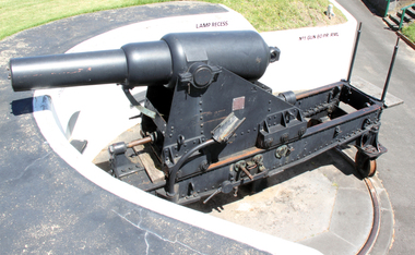
Weapon - Cannon, 1866
In the years following the Crimean War (1854-1857J) there was a great concern in the Colony that Imperial Russia would attempt an invasion. Coastal defences in the colony of Victoria were greatly strengthened by the Government as a result. Warrnambool was originally protected by cannons at Cannon Hill, approximately 1 kilometer west of the Flagstaff Hill Fortifications. These cannons included two 1866 guns, both 80 Pound Rifled Muzzle Loaders (RML) purchased by Victoria’s Colonial Government. They were part of a shipment of 26 such guns sent from England in December 1866. They are registered as No. 23 (80cwt-2qr-0lbs) - Gun 1, and No.13 (81cwt-1qr-12lbs) - Gun 2. They were cast at the Royal Gun Factory, Woolwich Arsenal, in 1866 and have a 6.3 inch bore. Both barrels carry the Royal Cypher of Queen Victoria, Insignia of the Royal Engineers, within the Garter and Motto surmounted by the Crown, with the Royal Cypher of Queen Victoria within the Garter (letters in centre “VR”, motto “HONI SOIT QUI MAL Y PENSE”, "Shame be to him who thinks evil of it."). The guns were originally supplied with wooden carriages. (The Royal Arsenal at Woolwich, England, was established eleven years after the Restoration of King Charles II. It was the principal supplier of armaments to the British and Empire Governments. At the height of its operations during World War One the factory covered 1300 acres and employed very nearly 80,000 workers. Woolwich was the Headquarters of the Royal Artillery since the raising of that Regiment in 1716. The Arsenal was closed in the late 1960’s.) These two cannons were transferred to the Warrnambool Garrison Artillery Battery Fortifications erected at Flagstaff Hill in 1887 as part of Victoria’s Coastal Defences. The original wooden carriages were subsequently replaced with the present iron garrison carriages in 1888. They are a “C” pivot. The ‘racers’ or curved track set into the floor of the gun emplacement (which enabled the guns to be traversed more quickly) are as specified for guns up to 10 inch, being of wrought iron 2.78 inches wide. A temporary third gun, now no longer on Flagstaff Hill’s site, was a 5 inch Rifled Breech Loading (BL) Armstrong gun mounted on an Elswick hydro pneumatic disappearing carriage It was faster to load and fire than the 80 pound RMLs and its arrival spelt the end of the older 80 pound guns’ useful life, apart from being used for practice sessions. The 5 inch BL gun was the main defensive weapon of the Warrnambool Battery until the Battery was downgraded in importance and the gun was recalled to Melbourne in 1910. The State of Victoria took over the ownership of the guns at the time of Australian Federation in 1901. In about 1901/1902 the Garrison Battery was converted to the Warrnambool Battery of the Australian Field Artillery (No 4 Field Battery). It was equipped with 4.7 inch naval guns mounted on field carriages. They were now a mobile unit but continued to use the Warrnambool Garrison area at Flagstaff Hill for practice. When the Fortifications were declared obsolete the two 80 Pounder RML were relocated to Cannon Hill in 1910. On the outbreak of World War One the 4.7 inch guns were recalled to Melbourne, and the Battery was disbanded. Most of the personnel probably re-enlisted in the local 4th Australian Light Horse Regiment. The two 80 Pounder RML were moved back to the Fortifications in 1973. They were both fully restored by Army First Year Apprentices at the Ordinance Factory in Bendigo in time for the centenary year of the fortifications in 1987. The guns are capable of firing 80 pound (32.3kg) armour piercing exploding shells 3.65kms out to sea. They were original manned by volunteers before a paid Garrison was established. Now the Guns are again fired by volunteers on Special Event days. Since restoration the Gun Number 1 had been fired on a regular basis but Gun Number 2 hadn’t been fired since the mid 1990’s. In April 2015 Gun Number 2 was serviced in preparation for the firing of both cannons on the ANZAC Centenary commemorations on April 25th 2015. Other guns from the original Cannon Hill location were obsolete by the time the 1887 Warrnambool Garrison Artillery Battery was built. These guns are (1) a 32 Pounder Muzzle Loading Smooth Bore (SB) cast in 1813 at the famous Carron Foundry, number 80837 and now located in the Warrnambool Botanic Gardens (2) a 68 Pounder Muzzle Loading Smooth Bore cast in 1861 at the equally august Low Moor Foundry, number 10310 and now located on the lawn area at the entrance to Flagstaff Hill Maritime Village. Both of these guns are mounted on their original wooden garrison carriages. There are only seven 32 Pounder SB made by Carron and fifteen 68 Pounder SB made at Low Moor known to exist in the State of Victoria (Conservation Management Plan for Victorian Guns and Cannon, South Western Victoria, May 2008, ref W/F/04)The Warrnambool Garrison has been added to the Victorian Heritage Register H1250 “for its intact battery and guns, a strong reminder of Victoria’s wealth and determination to protect itself from the perceived threat of invasion in the 1880’s.” The City of Warrnambool is one of several custodians of a collection of artillery pieces of heritage significance at a state, national and international level. These pieces are directly related to the defence of south-west Victoria in the 19th century. The care and preservation come under the Heritage Act 1995. Cannon. 80 Pounder Rifled Muzzle Loading (RML) Gun on iron carriage and slide, installed in the Battery at Flagstaff Hill’s Fortifications.. Made in 1866 at the Royal Gun Factory (R-G-F), Woolich, England. Gun Reg No - 23. Flagstaff Hill Garrison Gun 1 (Gun No. 1) Insignia of the Royal Engineers, and the weight of the gun, stamped on top of the gun’s barrel. There is a brass plate on the side of the gun with the details of 1987 restoration.Stamped on axle cover on side of barrel “R-G-F / No 23 / 1866”. Stamped into the metal on top of the barrel, Insignia of the Royal Engineers; Garter and Motto “HONI SOIT QUI MAL Y PENSE”, surmounted by the Crown, with the Royal Cypher of Queen Victoria “VR” within the Garter. Also stamped on top of the gun are 2 inward pointing arrows above the weight ”81-2-0”. Brass plate “RESTORATION / BY / FIRST YEAR / APPRENTICES / ORDANANCE FACTORY / BENDIGO 1987”flagstaff hill, warrnambool, shipwrecked coast, flagstaff hill maritime museum, maritime museum, shipwreck coast, flagstaff hill maritime village, great ocean road, cannon, 80 pounder, rifled muzzle, loading, royal gun factory, woolich -
 Flagstaff Hill Maritime Museum and Village
Weapon - Cannon, 1866
In the years following the Crimean War (1854-1857J) there was a great concern in the Colony that Imperial Russia would attempt an invasion. Coastal defences in the colony of Victoria were greatly strengthened by the Government as a result. Warrnambool was originally protected by cannons at Cannon Hill, approximately 1 kilometer west of the Flagstaff Hill Fortifications. These cannons included two 1866 guns, both 80 Pound Rifled Muzzle Loaders (RML) purchased by Victoria’s Colonial Government. They were part of a shipment of 26 such guns sent from England in December 1866. They are registered as No. 23 (80cwt-2qr-0lbs) - Gun 1, and No.13 (81cwt-1qr-12lbs) - Gun 2. They were cast at the Royal Gun Factory, Woolwich Arsenal, in 1866 and have a 6.3 inch bore. Both barrels carry the Royal Cypher of Queen Victoria, Insignia of the Royal Engineers, within the Garter and Motto surmounted by the Crown, with the Royal Cypher of Queen Victoria within the Garter (letters in centre “VR”, motto “HONI SOIT QUI MAL Y PENSE”, "Shame be to him who thinks evil of it."). The guns were originally supplied with wooden carriages. (The Royal Arsenal at Woolwich, England, was established eleven years after the Restoration of King Charles II. It was the principal supplier of armaments to the British and Empire Governments. At the height of its operations during World War One the factory covered 1300 acres and employed very nearly 80,000 workers. Woolwich was the Headquarters of the Royal Artillery since the raising of that Regiment in 1716. The Arsenal was closed in the late 1960’s.) These two cannons were transferred to the Warrnambool Garrison Artillery Battery Fortifications erected at Flagstaff Hill in 1887 as part of Victoria’s Coastal Defences. The original wooden carriages were subsequently replaced with the present iron garrison carriages in 1888. They are a “C” pivot. The ‘racers’ or curved track set into the floor of the gun emplacement (which enabled the guns to be traversed more quickly) are as specified for guns up to 10 inch, being of wrought iron 2.78 inches wide. A temporary third gun, now no longer on Flagstaff Hill’s site, was a 5 inch Rifled Breech Loading (BL) Armstrong gun mounted on an Elswick hydro pneumatic disappearing carriage It was faster to load and fire than the 80 pound RMLs and its arrival spelt the end of the older 80 pound guns’ useful life, apart from being used for practice sessions. The 5 inch BL gun was the main defensive weapon of the Warrnambool Battery until the Battery was downgraded in importance and the gun was recalled to Melbourne in 1910. The State of Victoria took over the ownership of the guns at the time of Australian Federation in 1901. In about 1901/1902 the Garrison Battery was converted to the Warrnambool Battery of the Australian Field Artillery (No 4 Field Battery). It was equipped with 4.7 inch naval guns mounted on field carriages. They were now a mobile unit but continued to use the Warrnambool Garrison area at Flagstaff Hill for practice. When the Fortifications were declared obsolete the two 80 Pounder RML were relocated to Cannon Hill in 1910. On the outbreak of World War One the 4.7 inch guns were recalled to Melbourne, and the Battery was disbanded. Most of the personnel probably re-enlisted in the local 4th Australian Light Horse Regiment. The two 80 Pounder RML were moved back to the Fortifications in 1973. They were both fully restored by Army First Year Apprentices at the Ordinance Factory in Bendigo in time for the centenary year of the fortifications in 1987. The guns are capable of firing 80 pound (32.3kg) armour piercing exploding shells 3.65kms out to sea. They were original manned by volunteers before a paid Garrison was established. Now the Guns are again fired by volunteers on Special Event days. Since restoration the Gun Number 1 had been fired on a regular basis but Gun Number 2 hadn’t been fired since the mid 1990’s. In April 2015 Gun Number 2 was serviced in preparation for the firing of both cannons on the ANZAC Centenary commemorations on April 25th 2015. Other guns from the original Cannon Hill location were obsolete by the time the 1887 Warrnambool Garrison Artillery Battery was built. These guns are (1) a 32 Pounder Muzzle Loading Smooth Bore (SB) cast in 1813 at the famous Carron Foundry, number 80837 and now located in the Warrnambool Botanic Gardens (2) a 68 Pounder Muzzle Loading Smooth Bore cast in 1861 at the equally august Low Moor Foundry, number 10310 and now located on the lawn area at the entrance to Flagstaff Hill Maritime Village. Both of these guns are mounted on their original wooden garrison carriages. There are only seven 32 Pounder SB made by Carron and fifteen 68 Pounder SB made at Low Moor known to exist in the State of Victoria (Conservation Management Plan for Victorian Guns and Cannon, South Western Victoria, May 2008, ref W/F/05)The Warrnambool Garrison has been added to the Victorian Heritage Register H1250 “for its intact battery and guns, a strong reminder of Victoria’s wealth and determination to protect itself from the perceived threat of invasion in the 1880’s.” The City of Warrnambool is one of several custodians of a collection of artillery pieces of heritage significance at a state, national and international level. These pieces are directly related to the defence of south-west Victoria in the 19th century. The care and preservation come under the Heritage Act 1995. Cannon. 80 Pound Rifled Muzzle Loading (RML) Gun on iron carriage and slide, installed in the Battery at Flagstaff Hill’s Fortifications. Made in 1866 at the Royal Gun Factory (R-G-F), Woolich, England. Gun Reg No 13. Flagstaff Hill Garrison Gun 2 (Gun No. 2). Insignia of the Royal Engineers, and the weight of the gun, stamped on top of the gun’s barrel. There is a brass plate on the side of the gun with the details of 1987 restoration.Stamped into the metal on top of the barrel, Insignia of the Royal Engineers; Garter and Motto “HONI SOIT QUI MAL Y PENSE”, surmounted by the Crown, with the Royal Cypher of Queen Victoria “VR” within the Garter. Also stamped on top of the gun are 2 inward pointing arrows above the weight ”81-1-12”. Brass plate “RESTORATION / BY / FIRST YEAR / APPRENTICES / ORDANANCE FACTORY / BENDIGO 1987”flagstaff hill, warrnambool, shipwrecked coast, flagstaff hill maritime museum, maritime museum, shipwreck coast, flagstaff hill maritime village, great ocean road, colonial defences, victoria’s coastal defences, warrnambool fortification, warrnambool garrison battery, warrnambool volunteer corps, ordinance, armaments, cannon hill fortifications, 4th australian light horse regiment, no 4 field battery, 80 pound cannon rifled muzzle loaders (rml), victorian colonial government, royal gun factory england, woolwich arsenal, royal cypher of queen victoria, garrison gun -
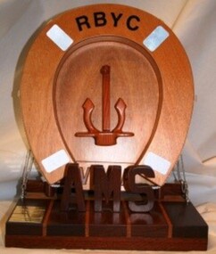 Royal Brighton Yacht Club
Life Ring, Vega Trophy (Mounted Wooden Life Ring)
Vega Trophy (Mounted Wooden Life Ring) Donor: Graham Noel During World War II when the Germans occupied the Channel Islands the local people went through very severe food rationing and were on the verge of starvation. Near the end of the war, the Swedish ship Vega was allowed by the Germans to deliver several shipments of food to the civilian population, easing the critical shortages of food on the islands. Further background detail can be found below. Graham Noel was born on the Islands and lived there during this harsh period. The trophy is awarded to the winner of the Combined Division AMS Aggregate Series. First Winner: Under Capricorn, P. Bedlington 2005/06 Vega – Further historical background Early in the Second World War Jersey was declared “unarmed” and the German military took over, taking quite a few lives in the process, through strafing the main harbour and a few other places which they needlessly considered threatening. A considerable number of locals evacuated to England before the Germans arrived, but more than 60% of the population remained and endured 5 years of very strict and difficult conditions. Not only was the population unable to contact relatives in the UK or elsewhere, but very quickly they found themselves subject to harsh curfews, strictly rationed foodstuffs, no fuel for vehicles, radios confiscated, and homes and hotels commandeered by the military. The military demanded first pick of all foodstuffs and kept meticulous records of all livestock forcing farmers even to show newborn calves and piglets to them, then claiming the new arrivals for their dinner tables. However there are many stories of farmers outwitting their masters when twin calves or suchlike arrived! Lawbreakers were quickly dealt with, mostly with lengthy prison terms in Jersey, but the more serious crimes were punished by being sent to some horrible French prisons, or even some of the notorious German concentration camps. All local Jews were dispatched to concentration camps, and even English born families were similarly shipped through France and on to Germany. Sadly, a considerable number of those deported did not make it back safely to Jersey. In June 1944 the locals were delighted to hear that the Allies had invaded Normandy and very soon they could hear the battles as the Allies worked their way along the French coast. Little did they know they would still have to wait another 11 months for freedom, having to put up with a very demanding German occupation force which was still determined to obey Hitler’s order to “Defend the Channel Islands to the death”. Now that France was in Allied Hands the local military commanders were unable to supplement their food supplies from France and even harsher demands were made on the local population to ensure that all branches of their still very substantial military force were reasonably well fed. As well as the military, Jersey farmers had to provide food for the Allied POWs and the many “forced labourers”, mainly of Russian, Polish and Italian backgrounds who had been directed to the island to build all the concrete bunkers. This included an underground hospital, all this complying with Hitler’s orders to ensure that the Channel Islands would never again be part of Britain. Many requests by the Jersey authorities for Red Cross assistance were rejected, but finally in December 1944 they agreed and on 30th December the Red Cross vessel “Vega” (Swedish Registry) arrived and delivered parcels to the civilian population. These parcels contained a variety of foodstuffs supplied mainly by Canadian authorities, desperately needed medical supplies, flour, oils and soaps, as well as tobacco from New Zealand. Vega made a further 3 or 4 trips and most certainly eased the desperate situation being faced by the locals. In fact, it resulted in the locals having slightly better food supplies than the military and many local farmers tell stories of having to protect their stock from marauding soldiers. Understandably Churchill was reluctant to send in an invading force to retake the Channel Islands, but by May 1945 it was clear that the Third Reich was finished and on May 9th the German Military surrendered, without a fight, to a large British landing force. On a slightly lighter note … in January 1945 Jersey stonemasons were seen in the main town square repairing flagstones … the Germans had never noticed that the name “Vega” had been formed in those flagstones! As a side note Vega is the name of the brightest star in the universe. Furthermore, throughout the occupation, despite German law that demanded confiscation of all radio sets, punishable by long prison terms or deportation to Germany, there were still many sets being listened to. The locals had a well refined news system for the dissemination of news of what was happening in the outside world. vega, graham noel, ams, combined division, aggregate -
 Bendigo Historical Society Inc.
Document - Marriage Certificates of Edward de Lacy Evans and Edmund de Lacy
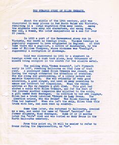
Edward (Edmund) de Lacy Evans was really Ellen Tremaye; and in 1856 she married her fellow passenger on her voyage to Australia, Mary Delahunty; under the assumed name of EDMUND De Lacy. In 1859 he/she married Sarah Moore. They were married for eight years when in 1867 she died in childbirth. In 1868 after Sarah had died; Ellen, now known as EDWARD de Lacy Evans married Julia Mary Marquand in Ballarat. From the Melbourne Argus Friday 5th Sept 1879, Page 7 THE EXTRAORDINARY PERSONATION CASE. [BY ELECTRIC TELEGRAPH. FROM OUR OWN CORRESPONDENT.) SANDHURST, THURSDAY. The De Lacy Evans case has created great excitement here. The man-woman having resided in the district for about 20 years, was well known amongst the miners, but no one appeared ever to have supposed that she was other than as she represented herself to be, and the discovery of her sex has caused the greatest astonishment. The police have not yet moved in the matter of the discovery of her antecedents, but from the result of inquiries I have made, there seems to be no room to doubt that the woman is identical with the girl Ellen Tremaye, referred to in yesterday's telegram as having arrived at Melbourne by the ship Ocean Monarch in June, 1857. The nurse at the hospital, Mrs. Holt, is positive she is the same, and says the opinion was held amongst those on board the vessel that Tremaye had been well connected, and that she had left home in consequence of some misconduct. The Ocean Monarch was an immigrant vessel, and on the voyage Tremaye and another young woman, named Rose Kelly, were very intimate, but the latter, being seized with a dangerous illness, was left at Rio Janiero. Mrs. Evans, the wife of the supposed man, states that she frequently heard Evans say that she came out by the Ocean Monarch. But the most satisfactory information of Evans' previous history yet received has been obtained from a Mrs. Thompson, a charwoman at Myers' Creek, who was also a shipmate of the girl Tremaye. At the time she made the voyage she was unmarried, and was accompanied by Miss Mary Ann Delahunty, a young lady who was very well connected, and who came from the same village as herself, named Monakine, on the north bank of the river Suir, in Kilkenny. Miss Delahunty was an orphan and brought with her about £900. After Rose Kelly was taken ill, Tremaye resorted to Miss Delahunty's berth, and the passengers appeared to think there was something strange about the manner in which Tremaye conducted herself, and she had been observed to wear a man's under-clothing. Upon the arrival of the ship in Hobson's Bay, Tremaye declared herself to be a man, and told Mrs. Thompson she intended to marry Miss Delahunty. The next Mrs. Thompson saw of Ellen Tremaye was at Peg-leg Gully, Eaglehawk. Tremaye had just established herself in a house there under the name of Edward de Lacy Evans, and Mrs. Thompson went to serve them with milk. When she went to the house, she saw Evans sitting inside dressed in male attire, and immediately recognised him as her fellow passenger, Ellen Tremaye. Evans had, at this time, married his second wife, Miss Moore, who was then present. Evans re-marked to her—"I think I know you." To which Mrs. Thompson replied—"I know you, too," and added something to the effect that Ellen (referring to Tremaye) was a queer girl." Oh, said Evans, evidently anxious that his then wife should not understand Mrs. Thompson's reference, "It's a good job she is gone back to the old country." Mrs. Thompson inquired as to what had become of Miss Delahunty, and Evans replied, "Oh, my poor wife and boy both died of consumption, and are buried in the North Melbourne cemetery. " In reply to an inquiry as to what had been done with her (Delahunty's) money, Evans said she had sent it home to a nunnery. Evans's then wife had been absent during a portion of this conversation, but at this point she returned, and Evans went outside to the milkwoman, and said, "For your life don't mention my dead wife's name ; call me Mr. Evans. This missus of mine is death on the Roman Catholics, and she can't bear to hear my dead wife's name mentioned." This conversation took place about 12 or 14 years ago, and Mrs. Thompson seems to have quite believed that Evans had personated a woman under the name of Ellen Tremaye on the voyage out and was really a man. She lost sight of Evans soon afterwards, and took no further notice of the affair.Two Photocopies: 1. Marriage Certificates of Edward de Lacy Evans to Julia Mary Marquand 18th Sept 1868 with appropriate marriage details. 2. Marriage Certificate dated 21st Mar 1985 for Edmund de Lacy to Mary Delahunty.ellen tremaye, sarah moore, julia mary marquand, mary delahunty, de lacy evans, de lacy, edward de lacy evans, edmund de lacy -
 Bendigo Historical Society Inc.
Document - DE LACY EVANS/ELLEN TREMAYE
Edward (Edmund) de Lacy Evans was really Ellen Tremaye; and in 1856 she married her fellow passenger on her voyage to Australia, Mary Delahunty; under the assumed name of EDMUND De Lacy. In 1859 he/she married Sarah Moore. They were married for eight years when in 1867 she died in childbirth. In 1868 after Sarah had died; Ellen, now known as EDWARD de Lacy Evans married Julia Mary Marquand in Ballarat. From the Melbourne Argus Friday 5th Sept 1879, Page 7 THE EXTRAORDINARY PERSONATION CASE. [BY ELECTRIC TELEGRAPH. FROM OUR OWN CORRESPONDENT.) SANDHURST, THURSDAY. The De Lacy Evans case has created great excitement here. The man-woman having resided in the district for about 20 years, was well known amongst the miners, but no one appeared ever to have supposed that she was other than as she represented herself to be, and the discovery of her sex has caused the greatest astonishment. The police have not yet moved in the matter of the discovery of her antecedents, but from the result of inquiries I have made, there seems to be no room to doubt that the woman is identical with the girl Ellen Tremaye, referred to in yesterday's telegram as having arrived at Melbourne by the ship Ocean Monarch in June, 1857. The nurse at the hospital, Mrs. Holt, is positive she is the same, and says the opinion was held amongst those on board the vessel that Tremaye had been well connected, and that she had left home in consequence of some misconduct. The Ocean Monarch was an immigrant vessel, and on the voyage Tremaye and another young woman, named Rose Kelly, were very intimate, but the latter, being seized with a dangerous illness, was left at Rio Janiero. Mrs. Evans, the wife of the supposed man, states that she frequently heard Evans say that she came out by the Ocean Monarch. But the most satisfactory information of Evans' previous history yet received has been obtained from a Mrs. Thompson, a charwoman at Myers' Creek, who was also a shipmate of the girl Tremaye. At the time she made the voyage she was unmarried, and was accompanied by Miss Mary Ann Delahunty, a young lady who was very well connected, and who came from the same village as herself, named Monakine, on the north bank of the river Suir, in Kilkenny. Miss Delahunty was an orphan and brought with her about £900. After Rose Kelly was taken ill, Tremaye resorted to Miss Delahunty's berth, and the passengers appeared to think there was something strange about the manner in which Tremaye conducted herself, and she had been observed to wear a man's under-clothing. Upon the arrival of the ship in Hobson's Bay, Tremaye declared herself to be a man, and told Mrs. Thompson she intended to marry Miss Delahunty. The next Mrs. Thompson saw of Ellen Tremaye was at Peg-leg Gully, Eaglehawk. Tremaye had just established herself in a house there under the name of Edward de Lacy Evans, and Mrs. Thompson went to serve them with milk. When she went to the house, she saw Evans sitting inside dressed in male attire, and immediately recognised him as her fellow passenger, Ellen Tremaye. Evans had, at this time, married his second wife, Miss Moore, who was then present. Evans re-marked to her—"I think I know you." To which Mrs. Thompson replied—"I know you, too," and added something to the effect that Ellen (referring to Tremaye) was a queer girl." Oh, said Evans, evidently anxious that his then wife should not understand Mrs. Thompson's reference, "It's a good job she is gone back to the old country." Mrs. Thompson inquired as to what had become of Miss Delahunty, and Evans replied, "Oh, my poor wife and boy both died of consumption, and are buried in the North Melbourne cemetery. " In reply to an inquiry as to what had been done with her (Delahunty's) money, Evans said she had sent it home to a nunnery. Evans's then wife had been absent during a portion of this conversation, but at this point she returned, and Evans went outside to the milkwoman, and said, "For your life don't mention my dead wife's name ; call me Mr. Evans. This missus of mine is death on the Roman Catholics, and she can't bear to hear my dead wife's name mentioned." This conversation took place about 12 or 14 years ago, and Mrs. Thompson seems to have quite believed that Evans had personated a woman under the name of Ellen Tremaye on the voyage out and was really a man. She lost sight of Evans soon afterwards, and took no further notice of the affair.Ballarat, Information re De Lacy Evans/Ellen Tremaye - various printed accounts of male impersonator, De Lacy Evans and his marriages and life in Bendigo and elsewhere. Filed under 'De Lacy Evans': a.Typescript - 'The strange story of Ellen Tremaye' (2 pp,); b.Newspaper cuttings (newspaper unknown): September 4, 1879 and 23rd July 1879. names mentioned on this report are; Evans, Stewart, The Trumpeter Clock, Mr. J. W. Moody, Edward De Lacy Evans, Samuels, Holdsworth, Dr. Cruikshank, Dr J. Boyd, Mr. Sterry J.P. (mayor), Mr. Osborn J.P. Elizabeth Marchment, Cornish United Company Long Gully, Constable Hayes, Mr. F. J. Duffy, Mr. J. Quick. C.Bendigo Advertiser 4th Sept 1879 (12 pages) - pp, 1-9 ''Extraordinary case of the concealment of sex'' (pp. 10-12) ''Interview with Mrs Evans''. Names on these sheets are; Edward De Lacy Evans, Sandhurst (Bendigo), Mr. Samuels, Mr. Holdsworth, Dr. Cruikshank, Dr. J. Boyd, Bendigo Hospital, Mr. Gundry (Warder), Irish, France, Dr. Poland, Mr. Bayne, Mr. Strickland, Kew Lunatic Asylum, Argus (newspaper), Sandhurst Hospital, Bendigo Hospital, County Kilkenny Ireland, Mrs Holt (Matron), Ellen Tremayne, Treneage, Eaglehawk, Sarah Moore, Mr. John J. Hall, Mr. George Willan, Buick Henderson and Co,. Pall Mall, Miss Julia Marquahand, Ballarat, Presbyterian Church, Rev. W. Henderson, Paris, Ellen McCormick, , Duncan Uquhart, Anne Dora (Welshman), Pleasant Creek, New Chum Extended Company, Julia Mary, Quarry Hill, Constable Bradley, General Sir Charles De Lacy Evans, Francis Bros Drapers of Pall Mall, Stawell, Allingham Drapers, View Grove Cottage Quarry Hill, Mrs Lofts Denmark Cottage Hargreaves Street, Jersey Cottage off Russell Street Quarry Hill, Great Southern Company, Sea Company, d.Single column entry, Bendigo Advertiser Dec 15th 1879: ''De Lacy Evans''. Names in the article; Ellen Tremayne, Sandhurst, Stawell, The Herald, Mr. F. Hilton, Diorama and Mirror of Australia, Horsham, The Horsham Times, Ireland. e. Newspaper article, by David Horsfall, Bendigo Advertiser Jan 10th 1990 (Title??) with photo of De Lacy Evans (standing); f.Newspaper article (poor legibility) Bendigo Advertiser Aug 27th 1901 ''Death of De Lacey Evans''; g.Newspaper article (undated) by Frank Cusack: ''Forgotten Bendigonians - Bendigo Goldfields und…??'' h.Journal article(3 pp.), The Medical Journal of Australia, Aug 26, 1978 by J R B Ball & R Emmerson: ''A case of personation'';i. copy of page #210 from unknown book (heading:'' Mount Royal Hospital'' j.27 pp.headed ''The Man-Woman Mystery'' (from bound book - binding visible - and copy in the Mitchell Library, publisher; W. Marshall, Royal Lane, Melbourne and Record Office, Emerald Hill with page (no page number) referring to two relevant documents ''The originals of these documents can be seen in the Hall'';Bendigo Advertiserjohn baptiste loridan, ellen tremaye, sarah moore, julia mary marquand, mary delahunty, de lacy evans, de lacy, edward de lacy evans, edmund de lacy, bendigo -
 Bendigo Historical Society Inc.
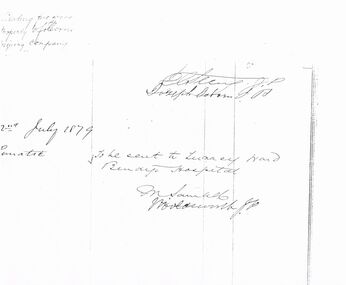
Document - CERTIFICATE (ORDER): ADMISSION TO LUNACY WARD: BENDIGO HOSPITAL
Edward (Edmund) de Lacy Evans was really Ellen Tremaye; and in 1856 she married her fellow passenger on her voyage to Australia, Mary Delahunty; under the assumed name of EDMUND De Lacy. In 1859 he/she married Sarah Moore. They were married for eight years when in 1867 she died in childbirth. In 1868 after Sarah had died; Ellen, now known as EDWARD de Lacy Evans married Julia Mary Marquand in Ballarat. From the Melbourne Argus Friday 5th Sept 1879, Page 7 THE EXTRAORDINARY PERSONATION CASE. [BY ELECTRIC TELEGRAPH. FROM OUR OWN CORRESPONDENT.) SANDHURST, THURSDAY. The De Lacy Evans case has created great excitement here. The man-woman having resided in the district for about 20 years, was well known amongst the miners, but no one appeared ever to have supposed that she was other than as she represented herself to be, and the discovery of her sex has caused the greatest astonishment. The police have not yet moved in the matter of the discovery of her antecedents, but from the result of inquiries I have made, there seems to be no room to doubt that the woman is identical with the girl Ellen Tremaye, referred to in yesterday's telegram as having arrived at Melbourne by the ship Ocean Monarch in June, 1857. The nurse at the hospital, Mrs. Holt, is positive she is the same, and says the opinion was held amongst those on board the vessel that Tremaye had been well connected, and that she had left home in consequence of some misconduct. The Ocean Monarch was an immigrant vessel, and on the voyage Tremaye and another young woman, named Rose Kelly, were very intimate, but the latter, being seized with a dangerous illness, was left at Rio Janiero. Mrs. Evans, the wife of the supposed man, states that she frequently heard Evans say that she came out by the Ocean Monarch. But the most satisfactory information of Evans' previous history yet received has been obtained from a Mrs. Thompson, a charwoman at Myers' Creek, who was also a shipmate of the girl Tremaye. At the time she made the voyage she was unmarried, and was accompanied by Miss Mary Ann Delahunty, a young lady who was very well connected, and who came from the same village as herself, named Monakine, on the north bank of the river Suir, in Kilkenny. Miss Delahunty was an orphan and brought with her about £900. After Rose Kelly was taken ill, Tremaye resorted to Miss Delahunty's berth, and the passengers appeared to think there was something strange about the manner in which Tremaye conducted herself, and she had been observed to wear a man's under-clothing. Upon the arrival of the ship in Hobson's Bay, Tremaye declared herself to be a man, and told Mrs. Thompson she intended to marry Miss Delahunty. The next Mrs. Thompson saw of Ellen Tremaye was at Peg-leg Gully, Eaglehawk. Tremaye had just established herself in a house there under the name of Edward de Lacy Evans, and Mrs. Thompson went to serve them with milk. When she went to the house, she saw Evans sitting inside dressed in male attire, and immediately recognised him as her fellow passenger, Ellen Tremaye. Evans had, at this time, married his second wife, Miss Moore, who was then present. Evans re-marked to her—"I think I know you." To which Mrs. Thompson replied—"I know you, too," and added something to the effect that Ellen (referring to Tremaye) was a queer girl." Oh, said Evans, evidently anxious that his then wife should not understand Mrs. Thompson's reference, "It's a good job she is gone back to the old country." Mrs. Thompson inquired as to what had become of Miss Delahunty, and Evans replied, "Oh, my poor wife and boy both died of consumption, and are buried in the North Melbourne cemetery. " In reply to an inquiry as to what had been done with her (Delahunty's) money, Evans said she had sent it home to a nunnery. Evans's then wife had been absent during a portion of this conversation, but at this point she returned, and Evans went outside to the milkwoman, and said, "For your life don't mention my dead wife's name ; call me Mr. Evans. This missus of mine is death on the Roman Catholics, and she can't bear to hear my dead wife's name mentioned." This conversation took place about 12 or 14 years ago, and Mrs. Thompson seems to have quite believed that Evans had personated a woman under the name of Ellen Tremaye on the voyage out and was really a man. She lost sight of Evans soon afterwards, and took no further notice of the affair.Certificate (Order) - Admission to Lunacy Ward, Bendigo Hospital 2/7/1879 signed by M Samuel Holdsworth(??) JP. Copy of Order. Other names on these sheets are; Ernst Hayes, Constable Bradley, Elizabeth Marchment, and other names that are unreadable.ellen tremaye, sarah moore, julia mary marquand, mary delahunty, de lacy evans, de lacy, edward de lacy evans, edmund de lacy, bendigo -
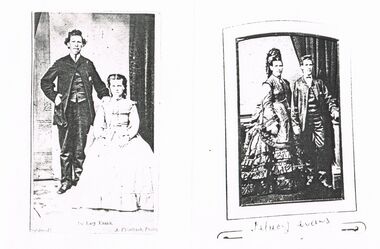 Bendigo Historical Society Inc.
Photograph - COPIES OF TWO STUDIO PHOTOGRAPHS: DE LACY EVANS
Edward (Edmund) de Lacy Evans was really Ellen Tremaye; and in 1856 she married her fellow passenger on her voyage to Australia, Mary Delahunty; under the assumed name of EDMUND De Lacy. In 1859 he/she married Sarah Moore. They were married for eight years when in 1867 she died in childbirth. In 1868 after Sarah had died; Ellen, now known as EDWARD de Lacy Evans married Julia Mary Marquand in Ballarat. From the Melbourne Argus Friday 5th Sept 1879, Page 7 THE EXTRAORDINARY PERSONATION CASE. [BY ELECTRIC TELEGRAPH. FROM OUR OWN CORRESPONDENT.) SANDHURST, THURSDAY. The De Lacy Evans case has created great excitement here. The man-woman having resided in the district for about 20 years, was well known amongst the miners, but no one appeared ever to have supposed that she was other than as she represented herself to be, and the discovery of her sex has caused the greatest astonishment. The police have not yet moved in the matter of the discovery of her antecedents, but from the result of inquiries I have made, there seems to be no room to doubt that the woman is identical with the girl Ellen Tremaye, referred to in yesterday's telegram as having arrived at Melbourne by the ship Ocean Monarch in June, 1857. The nurse at the hospital, Mrs. Holt, is positive she is the same, and says the opinion was held amongst those on board the vessel that Tremaye had been well connected, and that she had left home in consequence of some misconduct. The Ocean Monarch was an immigrant vessel, and on the voyage Tremaye and another young woman, named Rose Kelly, were very intimate, but the latter, being seized with a dangerous illness, was left at Rio Janiero. Mrs. Evans, the wife of the supposed man, states that she frequently heard Evans say that she came out by the Ocean Monarch. But the most satisfactory information of Evans' previous history yet received has been obtained from a Mrs. Thompson, a charwoman at Myers' Creek, who was also a shipmate of the girl Tremaye. At the time she made the voyage she was unmarried, and was accompanied by Miss Mary Ann Delahunty, a young lady who was very well connected, and who came from the same village as herself, named Monakine, on the north bank of the river Suir, in Kilkenny. Miss Delahunty was an orphan and brought with her about £900. After Rose Kelly was taken ill, Tremaye resorted to Miss Delahunty's berth, and the passengers appeared to think there was something strange about the manner in which Tremaye conducted herself, and she had been observed to wear a man's under-clothing. Upon the arrival of the ship in Hobson's Bay, Tremaye declared herself to be a man, and told Mrs. Thompson she intended to marry Miss Delahunty. The next Mrs. Thompson saw of Ellen Tremaye was at Peg-leg Gully, Eaglehawk. Tremaye had just established herself in a house there under the name of Edward de Lacy Evans, and Mrs. Thompson went to serve them with milk. When she went to the house, she saw Evans sitting inside dressed in male attire, and immediately recognised him as her fellow passenger, Ellen Tremaye. Evans had, at this time, married his second wife, Miss Moore, who was then present. Evans re-marked to her—"I think I know you." To which Mrs. Thompson replied—"I know you, too," and added something to the effect that Ellen (referring to Tremaye) was a queer girl." Oh, said Evans, evidently anxious that his then wife should not understand Mrs. Thompson's reference, "It's a good job she is gone back to the old country." Mrs. Thompson inquired as to what had become of Miss Delahunty, and Evans replied, "Oh, my poor wife and boy both died of consumption, and are buried in the North Melbourne cemetery. " In reply to an inquiry as to what had been done with her (Delahunty's) money, Evans said she had sent it home to a nunnery. Evans's then wife had been absent during a portion of this conversation, but at this point she returned, and Evans went outside to the milkwoman, and said, "For your life don't mention my dead wife's name ; call me Mr. Evans. This missus of mine is death on the Roman Catholics, and she can't bear to hear my dead wife's name mentioned." This conversation took place about 12 or 14 years ago, and Mrs. Thompson seems to have quite believed that Evans had personated a woman under the name of Ellen Tremaye on the voyage out and was really a man. She lost sight of Evans soon afterwards, and took no further notice of the affair.Copies of two studio Photographs - De Lacy Evans standing with seated woman: a. De Lacy Evans standing with woman seated; b. De Lacy Evans (handwritten below) with woman of same heighta. A. Flegeltaub b.??de lacy evans., ellen tremaye, sarah moore, julia mary marquand, mary delahunty, de lacy, edward de lacy evans, edmund de lacy -
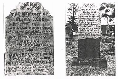 Bendigo Historical Society Inc.
Document - COPIES OF PHOTOGRAPHS OF TOMBSTONE: ELIZA JANE (AND SARAH DE LACY EVANS)
Edward (Edmund) de Lacy Evans was really Ellen Tremaye; and in 1856 she married her fellow passenger on her voyage to Australia, Mary Delahunty; under the assumed name of EDMUND De Lacy. In 1859 he/she married Sarah Moore. They were married for eight years when in 1867 she died in childbirth. In 1868 after Sarah had died; Ellen, now known as EDWARD de Lacy Evans married Julia Mary Marquand in Ballarat. From the Melbourne Argus Friday 5th Sept 1879, Page 7 THE EXTRAORDINARY PERSONATION CASE. [BY ELECTRIC TELEGRAPH. FROM OUR OWN CORRESPONDENT.) SANDHURST, THURSDAY. The De Lacy Evans case has created great excitement here. The man-woman having resided in the district for about 20 years, was well known amongst the miners, but no one appeared ever to have supposed that she was other than as she represented herself to be, and the discovery of her sex has caused the greatest astonishment. The police have not yet moved in the matter of the discovery of her antecedents, but from the result of inquiries I have made, there seems to be no room to doubt that the woman is identical with the girl Ellen Tremaye, referred to in yesterday's telegram as having arrived at Melbourne by the ship Ocean Monarch in June, 1857. The nurse at the hospital, Mrs. Holt, is positive she is the same, and says the opinion was held amongst those on board the vessel that Tremaye had been well connected, and that she had left home in consequence of some misconduct. The Ocean Monarch was an immigrant vessel, and on the voyage Tremaye and another young woman, named Rose Kelly, were very intimate, but the latter, being seized with a dangerous illness, was left at Rio Janiero. Mrs. Evans, the wife of the supposed man, states that she frequently heard Evans say that she came out by the Ocean Monarch. But the most satisfactory information of Evans' previous history yet received has been obtained from a Mrs. Thompson, a charwoman at Myers' Creek, who was also a shipmate of the girl Tremaye. At the time she made the voyage she was unmarried, and was accompanied by Miss Mary Ann Delahunty, a young lady who was very well connected, and who came from the same village as herself, named Monakine, on the north bank of the river Suir, in Kilkenny. Miss Delahunty was an orphan and brought with her about £900. After Rose Kelly was taken ill, Tremaye resorted to Miss Delahunty's berth, and the passengers appeared to think there was something strange about the manner in which Tremaye conducted herself, and she had been observed to wear a man's under-clothing. Upon the arrival of the ship in Hobson's Bay, Tremaye declared herself to be a man, and told Mrs. Thompson she intended to marry Miss Delahunty. The next Mrs. Thompson saw of Ellen Tremaye was at Peg-leg Gully, Eaglehawk. Tremaye had just established herself in a house there under the name of Edward de Lacy Evans, and Mrs. Thompson went to serve them with milk. When she went to the house, she saw Evans sitting inside dressed in male attire, and immediately recognised him as her fellow passenger, Ellen Tremaye. Evans had, at this time, married his second wife, Miss Moore, who was then present. Evans re-marked to her—"I think I know you." To which Mrs. Thompson replied—"I know you, too," and added something to the effect that Ellen (referring to Tremaye) was a queer girl." Oh, said Evans, evidently anxious that his then wife should not understand Mrs. Thompson's reference, "It's a good job she is gone back to the old country." Mrs. Thompson inquired as to what had become of Miss Delahunty, and Evans replied, "Oh, my poor wife and boy both died of consumption, and are buried in the North Melbourne cemetery. " In reply to an inquiry as to what had been done with her (Delahunty's) money, Evans said she had sent it home to a nunnery. Evans's then wife had been absent during a portion of this conversation, but at this point she returned, and Evans went outside to the milkwoman, and said, "For your life don't mention my dead wife's name ; call me Mr. Evans. This missus of mine is death on the Roman Catholics, and she can't bear to hear my dead wife's name mentioned." This conversation took place about 12 or 14 years ago, and Mrs. Thompson seems to have quite believed that Evans had personated a woman under the name of Ellen Tremaye on the voyage out and was really a man. She lost sight of Evans soon afterwards, and took no further notice of the affair.Copies of Photographs of Tombstone - Eliza Jane Ponsford and daughter Matilda and Sarah De Lacy Evans (''who was the sister of Eliza Jane Ponsford''). One photo showing detail of text; the other showing background of cemetery. (De Lacey)eliza jane ponsford, ellen tremaye, sarah moore, julia mary marquand, mary delahunty, de lacy evans, de lacy, edward de lacy evans, edmund de lacy, bendigo -
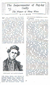 Bendigo Historical Society Inc.
Document - LONG GULLY HISTORY GROUP COLLECTION: THE IMPERSONATOR OF PEG-LEG GULLY
Edward (Edmund) de Lacy Evans was really Ellen Tremaye; and in 1856 she married her fellow passenger on her voyage to Australia, Mary Delahunty; under the assumed name of EDMUND De Lacy. In 1859 he/she married Sarah Moore. They were married for eight years when in 1867 she died in childbirth. In 1868 after Sarah had died; Ellen, now known as EDWARD de Lacy Evans married Julia Mary Marquand in Ballarat. From the Melbourne Argus Friday 5th Sept 1879, Page 7 THE EXTRAORDINARY PERSONATION CASE. [BY ELECTRIC TELEGRAPH. FROM OUR OWN CORRESPONDENT.) SANDHURST, THURSDAY. The De Lacy Evans case has created great excitement here. The man-woman having resided in the district for about 20 years, was well known amongst the miners, but no one appeared ever to have supposed that she was other than as she represented herself to be, and the discovery of her sex has caused the greatest astonishment. The police have not yet moved in the matter of the discovery of her antecedents, but from the result of inquiries I have made, there seems to be no room to doubt that the woman is identical with the girl Ellen Tremaye, referred to in yesterday's telegram as having arrived at Melbourne by the ship Ocean Monarch in June, 1857. The nurse at the hospital, Mrs. Holt, is positive she is the same, and says the opinion was held amongst those on board the vessel that Tremaye had been well connected, and that she had left home in consequence of some misconduct. The Ocean Monarch was an immigrant vessel, and on the voyage Tremaye and another young woman, named Rose Kelly, were very intimate, but the latter, being seized with a dangerous illness, was left at Rio Janiero. Mrs. Evans, the wife of the supposed man, states that she frequently heard Evans say that she came out by the Ocean Monarch. But the most satisfactory information of Evans' previous history yet received has been obtained from a Mrs. Thompson, a charwoman at Myers' Creek, who was also a shipmate of the girl Tremaye. At the time she made the voyage she was unmarried, and was accompanied by Miss Mary Ann Delahunty, a young lady who was very well connected, and who came from the same village as herself, named Monakine, on the north bank of the river Suir, in Kilkenny. Miss Delahunty was an orphan and brought with her about £900. After Rose Kelly was taken ill, Tremaye resorted to Miss Delahunty's berth, and the passengers appeared to think there was something strange about the manner in which Tremaye conducted herself, and she had been observed to wear a man's under-clothing. Upon the arrival of the ship in Hobson's Bay, Tremaye declared herself to be a man, and told Mrs. Thompson she intended to marry Miss Delahunty. The next Mrs. Thompson saw of Ellen Tremaye was at Peg-leg Gully, Eaglehawk. Tremaye had just established herself in a house there under the name of Edward de Lacy Evans, and Mrs. Thompson went to serve them with milk. When she went to the house, she saw Evans sitting inside dressed in male attire, and immediately recognised him as her fellow passenger, Ellen Tremaye. Evans had, at this time, married his second wife, Miss Moore, who was then present. Evans re-marked to her—"I think I know you." To which Mrs. Thompson replied—"I know you, too," and added something to the effect that Ellen (referring to Tremaye) was a queer girl." Oh, said Evans, evidently anxious that his then wife should not understand Mrs. Thompson's reference, "It's a good job she is gone back to the old country." Mrs. Thompson inquired as to what had become of Miss Delahunty, and Evans replied, "Oh, my poor wife and boy both died of consumption, and are buried in the North Melbourne cemetery. " In reply to an inquiry as to what had been done with her (Delahunty's) money, Evans said she had sent it home to a nunnery. Evans's then wife had been absent during a portion of this conversation, but at this point she returned, and Evans went outside to the milkwoman, and said, "For your life don't mention my dead wife's name ; call me Mr. Evans. This missus of mine is death on the Roman Catholics, and she can't bear to hear my dead wife's name mentioned." This conversation took place about 12 or 14 years ago, and Mrs. Thompson seems to have quite believed that Evans had personated a woman under the name of Ellen Tremaye on the voyage out and was really a man. She lost sight of Evans soon afterwards, and took no further notice of the affair.Copy of a newspaper article titled The Impersonator of Peg-leg Gully, The Woman of Many Wives by J P Quaine. Article mentions Edward De Lacy Evans who successfully impersonated a male and was married at least three times. After a head injury Evans was admitted to the Bendigo Hospital as a lunatic and remained for some weeks without arousing any suspicions. The secret was discovered when transferred to a Melbourne Institution. After improvement she returned to the Bendigo Hospital until she was well enough to leave the colony.bendigo, the long gully history group - the impersonator of peg-leg gully, j p quaine, edward de lacey evans, monarch of the ocean, bendigo hospital, ellen tremaye, sarah moore, julia mary marquand, mary delahunty, de lacy evans, de lacy, edward de lacy evans, edmund de lacy -
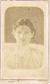 Bendigo Historical Society Inc.
Photograph - STUDIO PHOTOGRAPH OF DE LACY EVANS
Edward (Edmund) de Lacy Evans was really Ellen Tremaye; and in 1856 she married her fellow passenger on her voyage to Australia, Mary Delahunty; under the assumed name of EDMUND De Lacy. In 1859 he/she married Sarah Moore. They were married for eight years when in 1867 she died in childbirth. In 1868 after Sarah had died; Ellen, now known as EDWARD de Lacy Evans married Julia Mary Marquand in Ballarat. From the Melbourne Argus Friday 5th Sept 1879, Page 7 THE EXTRAORDINARY PERSONATION CASE. [BY ELECTRIC TELEGRAPH. FROM OUR OWN CORRESPONDENT.) SANDHURST, THURSDAY. The De Lacy Evans case has created great excitement here. The man-woman having resided in the district for about 20 years, was well known amongst the miners, but no one appeared ever to have supposed that she was other than as she represented herself to be, and the discovery of her sex has caused the greatest astonishment. The police have not yet moved in the matter of the discovery of her antecedents, but from the result of inquiries I have made, there seems to be no room to doubt that the woman is identical with the girl Ellen Tremaye, referred to in yesterday's telegram as having arrived at Melbourne by the ship Ocean Monarch in June, 1857. The nurse at the hospital, Mrs. Holt, is positive she is the same, and says the opinion was held amongst those on board the vessel that Tremaye had been well connected, and that she had left home in consequence of some misconduct. The Ocean Monarch was an immigrant vessel, and on the voyage Tremaye and another young woman, named Rose Kelly, were very intimate, but the latter, being seized with a dangerous illness, was left at Rio Janiero. Mrs. Evans, the wife of the supposed man, states that she frequently heard Evans say that she came out by the Ocean Monarch. But the most satisfactory information of Evans' previous history yet received has been obtained from a Mrs. Thompson, a charwoman at Myers' Creek, who was also a shipmate of the girl Tremaye. At the time she made the voyage she was unmarried, and was accompanied by Miss Mary Ann Delahunty, a young lady who was very well connected, and who came from the same village as herself, named Monakine, on the north bank of the river Suir, in Kilkenny. Miss Delahunty was an orphan and brought with her about £900. After Rose Kelly was taken ill, Tremaye resorted to Miss Delahunty's berth, and the passengers appeared to think there was something strange about the manner in which Tremaye conducted herself, and she had been observed to wear a man's under-clothing. Upon the arrival of the ship in Hobson's Bay, Tremaye declared herself to be a man, and told Mrs. Thompson she intended to marry Miss Delahunty. The next Mrs. Thompson saw of Ellen Tremaye was at Peg-leg Gully, Eaglehawk. Tremaye had just established herself in a house there under the name of Edward de Lacy Evans, and Mrs. Thompson went to serve them with milk. When she went to the house, she saw Evans sitting inside dressed in male attire, and immediately recognised him as her fellow passenger, Ellen Tremaye. Evans had, at this time, married his second wife, Miss Moore, who was then present. Evans re-marked to her—"I think I know you." To which Mrs. Thompson replied—"I know you, too," and added something to the effect that Ellen (referring to Tremaye) was a queer girl." Oh, said Evans, evidently anxious that his then wife should not understand Mrs. Thompson's reference, "It's a good job she is gone back to the old country." Mrs. Thompson inquired as to what had become of Miss Delahunty, and Evans replied, "Oh, my poor wife and boy both died of consumption, and are buried in the North Melbourne cemetery. " In reply to an inquiry as to what had been done with her (Delahunty's) money, Evans said she had sent it home to a nunnery. Evans's then wife had been absent during a portion of this conversation, but at this point she returned, and Evans went outside to the milkwoman, and said, "For your life don't mention my dead wife's name ; call me Mr. Evans. This missus of mine is death on the Roman Catholics, and she can't bear to hear my dead wife's name mentioned." This conversation took place about 12 or 14 years ago, and Mrs. Thompson seems to have quite believed that Evans had personated a woman under the name of Ellen Tremaye on the voyage out and was really a man. She lost sight of Evans soon afterwards, and took no further notice of the affair.With a card (for exhibition??) entitled '' The only known photograph of the enigmatical De Lacy Evans who for many years impersonated a man and was by occupation a gold miner''. Date 1877 (1880 crossed out). On the reverse side is the name N. White photographer Mitchell St Sandhurst, Opposite St. Paul's Tower.N W White, Mitchell St, Sandhurstperson, individual, male impersonater., ellen tremaye, sarah moore, julia mary marquand, mary delahunty, de lacy evans, de lacy, edward de lacy evans, edmund de lacy -
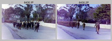 Bendigo Military Museum
Photograph - Army Headquarters (AHQ) Survey Regiment Freedom of Entry Parade, Bendigo CBD, 1970
The Freedom of Entry to the City was an honour conferred by the Bendigo City Council to the AHQ Survey Regiment on the 20th of April 1970. The unit was granted for the first time the privilege of marching into the city with swords drawn, bayonets fixed and drums beating. The honour is usually bestowed upon local regiments, in recognition of their dedicated service, and it is common for military units to periodically exercise their freedom by arranging a parade through the city. The Freedom of Entry Parade occurred on the 14th of June 1970 led by the Regiment’s CO – LTCOL Bill Sprenger MID, MBE; the unit marched up View St in the CBD to the Queen Elizabeth II Oval. The ceremonial parade followed with a march past the guests of honour, Mayor of Bendigo Councillor Clark Jeffrey and military dignitaries. The parade concluded after formal inspections of the troops. A ceremonial scroll was presented to the Bendigo City Council to the AHQ Survey Regiment citing the occasion and was proudly displayed in the entry foyer to Fortuna Villa up to October 2008. The Regiment continued to exercise its Freedom of Entry with anniversary parades in 1977, 1980, 1985, 1990 and 1995. Refer to item 6020.8P for another set of photos of this event scanned from photographic prints.This set of 39 colour photographs were taken on the occasion of the Army Headquarters (AHQ) Survey Regiment’s Freedom of Entry parade to the City of Bendigo on the 14th of June 1970. The photographs are on 35mm negative film. They are part of the Army Survey Regiment’s Collection. The photographic negatives were scanned at 96 dpi. .1) to .2) - Photo, colour, 1970. AHQ Survey Regiment marches to Queen Elizabeth Oval entry, led by CO LTCOL Lionel Sprenger MBE, MID, unidentified 2IC and RSM WO1 John Hogan. .3) to .4) - Photo, colour, 1970. AHQ Survey Regiment at entry to Queen Elizabeth Oval, exercising its right of entry to City of Bendigo. .5) to .6) - Photo, colour, 1970. AHQ Survey Regiment marches down View St in the City of Bendigo. .7) to .11) - Photo, colour, 1970. AHQ Survey Regiment marches up View St in the City of Bendigo. .12) to .13) - Photo, colour, 1970. AHQ Survey Regiment enters Queen Elizabeth Oval, led by CO LTCOL Lionel Sprenger MBE, MID, unidentified 2IC and RSM WO1 John Hogan. .14) - Photo, colour, 1970. One of AHQ Survey Regiment’s squadrons enters Queen Elizabeth Oval. .15) to .19) - Photo, colour, 1970. AHQ Survey Regiment forms up on Queen Elizabeth Oval awaiting arrival of dignitaries. .20) - Photo, colour, 1970. AHQ Survey Regiment inspected by dignitaries. L to R: Director of the Survey Corps COL Frank Buckland OBE, MID; Colonel Commandant BRIG Don Macdonald AM, MID; unidentified General, CO LTCOL Lionel Sprenger MBE, MID, Mayor of Bendigo Councillor Clark Jeffrey, unidentified personnel. .21) to .23) - Photo, colour, 1970. AHQ Survey Regiment inspected by dignitaries. Director of the Survey Corps COL Frank Buckland OBE, MID; Colonel Commandant BRIG Don Macdonald AM, MID; unidentified General, CO LTCOL Lionel Sprenger MBE, MID, Mayor of Bendigo Councillor Clark Jeffrey. WRAAC personnel centre rank - PTE Desi Asaris, rear rank L to R: unidentified, PTE Pat Lumsden, PTE Heather (Turnbull) Slater, SGT Irene (Rankins) Saunders. .24) to .27) - Photo, colour, 1970. Band inspected by dignitaries. Director of the Survey Corps COL Frank Buckland OBE, MID; Colonel Commandant BRIG Don Macdonald AM, MID; unidentified General, CO LTCOL Lionel Sprenger MBE, MID, Mayor of Bendigo Councillor Clark Jeffrey. .28) to .30) - Dignitaries return to dias. Director of the Survey Corps COL Frank Buckland OBE, MID; Colonel Commandant BRIG Don Macdonald AM, MID; unidentified General, CO LTCOL Lionel Sprenger MBE, MID, Mayor of Bendigo Councillor Clark Jeffrey.Director of the Survey Corps COL Frank Buckland OBE, MID; Colonel Commandant BRIG Don Macdonald AM, MID; unidentified General, CO LTCOL Lionel Sprenger MBE, MID, Mayor of Bendigo Councillor Clark Jeffrey. .31) - Photo, colour, 1970. Unidentified Padre’s Freedom of Entry parade address. .32) - Photo, colour, 1970. AHQ Survey Regiment during the unidentified Padre’s Freedom of Entry parade address. .33) to .35) - Photo, colour, 1970. AHQ Survey Regiment led by CO LTCOL Lionel Sprenger MBE, MID, unidentified 2IC and RSM WO1 John Hogan march past the dais to salute the parade dignitaries. .36) - Photo, colour, 1970. Parade dignitaries at the dais: unidentified councillor, Mayor of Bendigo Councillor Clark Jeffrey. Colonel Commandant BRIG Don Macdonald AM, MID; unidentified General. .37) to .38) - Photo, colour, 1970. AHQ Survey Regiment squadrons march past the dais to salute the parade dignitaries. .39) - Photo, colour, 1970. AHQ Survey Regiment WRAAC personnel march past the dais to salute the parade dignitaries. L to R: unidentified (x2), CPL Beryl Parkinson, unidentified (x2), PTE Robyn (Marsh) Kemsley, unidentified, WO2 Marj Knight, PTE Desi Asaris, PTE Heather (Turnbull) Slater, SGT Irene (Rankins) Saunders..1P to .3P – no annotationsroyal australian survey corps, rasvy, army survey regiment, army svy regt, fortuna, asr -
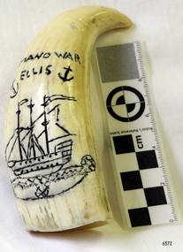 Flagstaff Hill Maritime Museum and Village
Craft - Scrimshaw, Late 20th century
The ship “Ellis” started life as the Clementina, launched in America in 1781. The vessel was first listed in Lloyd's Register in 1784 and under this name began serving as a slave ship sailing out of Liverpool. A Lloyd’s database records of slave-trading voyages by vessels from Liverpool makes it clear that Clementina was a slave trader. The next year Captain J. Elworthy sailed her to West Central Africa and St Helena. He transported his slaves to South Carolina. Then in 1785 Elworthy gathered slaves in the Bight of Biafra and the Gulf of Guinea Islands for delivery to Jamaica. In 1786 Bent & Co. purchased the Clementina and renamed her Ellis, presumably after the then owner Ellis Bent. She remained in the slave trade and In 1788 Captain John Ford sailed the now renamed Ellis to the Bight of Biafra and the Gulf of Guinea to gather slaves. He delivered this batch of slaves to the island of Grenada. The next year, 1789 the Ellis was almost completely rebuilt, and from the change in subsequent reports of her cargo loading or (burthen), she was enlarged. In 1791, Captain Joseph Matthews became master and sailed the Ellis to the Gold Coast then delivering his consignment of slaves to the island of St Vincent. During this voyage, some misfortune may have befallen Matthews because records show the Ellis command was transferred to Thomas Given. In 1792, Given sailed to the Bight of Biafra and the Islands in the Gulf of Guinea, again collecting slaves for delivery to Jamaica. There is a parallel record, also for 1793, that the Ellis under the command of Thomas Heart, undertook the same journey and with the same itinerary and cargo. In 1793, Bent & Co. decided to use the Ellis as a privateer with John Levingston as the master. After receiving a letter of "marque” on the 3rd of June 1793, that allowed any armed vessel to commit acts on the high seas which would otherwise have constituted piracy. Thus the Ellis began to operate as a combat ship under the endorsement of the British navy. The Ellis was three times captured first by the French frigate Gracieuse, under the command of Captain Chevillard on 22 July 1793. The French took her into service and renamed her as ”Elise”. Later that summer the Spanish captured her and in November ownership returned to the French who then renamed her the “Esperance”. On the 8th of June 1794, Esperance arrived in Jacmel, Saint-Domingue (present-day Haiti), from France with the official proclamation of the abolition of slavery. Leger-Felicite Sonthonax was one of the Civil Commissioners of Saint-Domingue and he had already unilaterally proclaimed the island for the French colony the year before amid a slave rebellion and attacks from British and Spanish forces. Ironically, Esperance also brought the news to the Civil Commissioners that the National Convention of France had impeached them on 16th July 1793 and ordered them to return promptly to France. On 8 January 1795, HMS Argonaut, under the command of Captain Alexander John Ball, captured Esperance while she was on the North America station. At this time the Esperance was armed with 22 guns (4 and 6-pounders) and had a crew of 130 men. She was under the command of Lieutenant de vaisseau De St. Laurent and had been out at sea for 56 days from Rochfort, bound for the American Chesapeake Bay area. The French ambassador to the United States registered a complaint with the President of the United States that Argonaut, by stating that by entering Lynnhaven bay, either before she captured Esperance or shortly thereafter, had violated a treaty between France and the United States. The French also accused the British of having brought the Esperance into Lynnhaven for refitting for a cruise. The British Consul replied that the capture had taken place some 10 leagues offshore as the bad weather had forced Argonaut and her prize to shelter within the Chesapeake area for some days, but that they had left as soon as practicable. Furthermore, Argonaut had paroled her French prisoners on arrival at Lynnhaven, and if she had entered American territorial waters solely to parole her French prisoners no one would have thought that objectionable. Royal Navy Service: Because the Esperance was captured in good order and sailed well, Rear Admiral George Murray, the British commander in chief of the North American station, put a British crew aboard and sent the Esperance out on patrol with HMS Lynx, under the command of John Poo Beresford, on 31st January. On 1st March the two vessels captured the Cocarde Nationale (or National Cockade), a privateer from Charleston, South Carolina, of 14 guns, six swivel cannons and a crew of 80 men. Esperance and the lynx went on to recaptured the ship Norfolk, of Belfast, and the brig George, of Workington. On 20 July, Esperance, in company with frigates Thetis and Hussar, intercepted the American vessel Cincinnatus, of Wilmington, sailing from Ireland to Wilmington. They pressed many men on board into service, narrowly missing the Irish revolutionary Wolfe Tone, who was on his way to Philadelphia. Esperance was formally commissioned in 1795 into the Royal Navy in August under the Command of Jonas Rose. On 4 May 1796 Esperance was sailing in company with HMS Spencer and Bonetta when they sighted a suspicious vessel. Spencer set off in chase while shortly thereafter Esperance saw two vessels, a schooner and a sloop, and she and Bonetta set off after them. Spencer sailed south by south-east and the other two British vessels sailed south-west by west, with the result that they lost sight of each other. Spencer captured the French gun-brig Volcan, while Bonetta and Esperance captured the French schooner Poisson Volant. The Esperance eventually arrived at Portsmouth on the 3rd of November 1797, the crew was paid off and on 31st May 1798 the Admiralty listed the Esperance for sale and she was sold in June 1798 for £600.The subject scrimshaw is a modern reproduction crudely done of a historic vessel and the scene is believed to be engraved onto a synthetic substance. Scrimshaw art crudely carved into non-natural material in the shape of a tooth. The line artwork is an image of a three-masted sailing ship with a poop deck, and anchors, are coloured black. Inscription is engraved into tooth.Engraved "Man o War Ellis" warrnambool, flagstaff-hill, flagstaff-hill-maritime-museum, maritime-museum, shipwreck-coast, flagstaff-hill-maritime-village, scrimshaw, ellis, esperance, clementina, elise, hms ship, man of war, leter of marque, privateer, slave ship, slavery, ellis bent, american war of inderpendance, marine art, marine artifact, whale tooth, ivory tooth, resin, plastic, craft, engraving, carving -
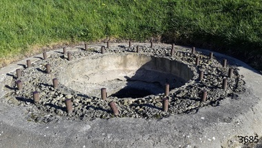 Flagstaff Hill Maritime Museum and Village
Gun Emplacement, 1890's
The Warrnambool Battery on Flagstaff Hill has embankments for 3 guns. Those on the left and right still have cannon in place but in the centre is an empty embankment, apart from this concrete ring with metal threaded studs. In 1898 a 5 inch breech loading gun (BL) was installed here. The gun had a hydro-pneumatic disappearing carriage (hence the sign on the concrete wall "5" BL HP").. This type of gun was faster to load and fire that the 80 pound RML’s installed on either side of it. Its arrival spelt the end of the 80 pound RML guns’ useful life, although they continued to be used for practice sessions. The 5 inch BL was the main defensive weapon of the Warrnambool Battery until the Battery was downgraded in importance. It was removed in 1904 and recalled to Melbourne in 1910. The gun emplacement ring is all that remains of the mounting for a 5 inch Armstrong rifled breech loading gun. HISTOR of the WARRNAMBOOL GUNS & CANNON In the years following the Crimean War (1854-1857J) there was a great concern in the Colony that Imperial Russia would attempt an invasion. Coastal defences in the colony of Victoria were greatly strengthened by the Government as a result. Warrnambool was originally protected by cannons at Cannon Hill, approximately 1 kilometer west of the Flagstaff Hill Fortifications. The cannons included two 1866 guns, both 80 Pound Rifled Muzzle Loaders (RML) purchased by Victoria’s Colonial Government. They were part of a shipment of 26 such guns sent from England in December 1866. They are registered as No. 23 (80cwt-2qr-0lbs) - Gun 1, and No.13 (81cwt-1qr-12lbs) - Gun 2. They were cast at the Royal Gun Factory, Woolwich Arsenal, in 1866 and have a 6.3 inch bore. Both barrels carry the Royal Cypher of Queen Victoria, Insignia of the Royal Engineers, within the Garter and Motto surmounted by the Crown, with the Royal Cypher of Queen Victoria within the Garter (letters in centre “VR”, motto “HONI SOIT QUI MAL Y PENSE”, "Shame be to him who thinks evil of it."). The guns were originally supplied with wooden carriages. (The Royal Arsenal at Woolwich, England, was established eleven years after the Restoration of King Charles II. It was the principal supplier of armaments to the British and Empire Governments. At the height of its operations during World War One the factory covered 1300 acres and employed very nearly 80,000 workers. Woolwich was the Headquarters of the Royal Artillery since the raising of that Regiment in 1716. The Arsenal was closed in the late 1960’s.) These two 80pdr cannons were transferred to the Warrnambool Garrison Artillery Battery Fortifications erected at Flagstaff Hill in 1887 as part of Victoria’s Coastal Defences. The original wooden carriages were subsequently replaced with the present iron garrison carriages in 1888. They are a “C” pivot. The ‘racers’ or curved track set into the floor of the gun emplacement (which enabled the guns to be traversed more quickly) are as specified for guns up to 10 inch, being of wrought iron 2.78 inches wide. A temporary third gun, now no longer on Flagstaff Hill’s site, was the 5 inch Rifled Breech Loading (BL) Armstrong gun mounted on an Elswick hydro pneumatic disappearing carriage and installed in this very concrete base or pad. The State of Victoria took over the ownership of the guns at the time of Australian Federation in 1901. In about 1901/1902 the Garrison Battery was converted to the Warrnambool Battery of the Australian Field Artillery (No 4 Field Battery). It was equipped with 4.7 inch naval guns mounted on field carriages. They were now a mobile unit but continued to use the Warrnambool Garrison area at Flagstaff Hill for practice. When the Fortifications were declared obsolete the two 80 Pounder RML were relocated to Cannon Hill in 1910. On the outbreak of World War One the 4.7 inch guns were recalled to Melbourne, and the Battery was disbanded. Most of the personnel probably re-enlisted in the local 4th Australian Light Horse Regiment. The two 80 Pounder RML were moved back to the Fortifications in 1973. They were both fully restored by Army First Year Apprentices at the Ordinance Factory in Bendigo in time for the centenary year of the fortifications in 1987. The guns are capable of firing 80 pound (32.3kg) armour piercing exploding shells 3.65kms out to sea. They were originally manned by volunteers before a paid Garrison was established. Now the Guns are again fired by volunteers on Special Event days. Since restoration the Gun Number 1 had been fired on a regular basis but Gun Number 2 hadn’t been fired since the mid 1990’s. In April 2015 Gun Number 2 was serviced in preparation for the firing of both cannons on the ANZAC Centenary commemorations on April 25th 2015. Other guns from the original Cannon Hill location were obsolete by the time the 1887 Warrnambool Garrison Artillery Battery was built. These guns are (1) a 32 Pounder Muzzle Loading Smooth Bore (SB) cast in 1813 at the famous Carron Foundry, number 80837 and now located in the Warrnambool Botanic Gardens. It is now mounted on a replica carriage due to the original carriage being in a fragile condition (the original carriage stored under cover at Flagstaff Hill). (2) a 68 Pounder Muzzle Loading Smooth Bore cast in 1861 at the equally august Low Moor Foundry, number 10310 and now located on the lawn area at the entrance to Flagstaff Hill Maritime Village. It is still mounted on its original wooden garrison carriage. Its wooden slide compressor mechanism is fragile and now kept in Flagstaff Hill’s storage. There are only seven 32 Pounder SB made by Carron and fifteen 68 Pounder SB made at Low Moor known to exist in the State of Victoria [references; Flagstaff Hill Maritime Village interpretation boards, information sheets and other documents; South Western Victoria Guns and Cannon report, May 2008, ref W/F/08] The Gun embankment is contained within the heritage listed Lady Bay Lighthouse Comples, on the Victorian Heritage Register VHR H1520. The gun emplacement base is evidence of the last defences installed on this stretch of coastline. The Warrnambool Garrison has been added to the Victorian Heritage Register H1250 “for its intact battery and guns, a strong reminder of Victoria’s wealth and determination to protect itself from the perceived threat of invasion in the 1880’s.” The City of Warrnambool is one of several custodians of a collection of artillery pieces of heritage significance at a state, national and international level. These pieces are directly related to the defence of south-west Victoria in the 19th century. The care and preservation come under the Heritage Act 1995. Gun emplacement; the remains of the mounting platform of a temporary third gun installed in 1898 in the centre of the battery. This consists of a circular concrete well or sump surrounded by two rings of mounting bolts, the inner of 10 and the outer of 20. The base once held a 5 inch Armstrong rifled breech loading gun with hydro-pneumatic disappearing. In the centre of the ring on the ground is a keyhole shaped space. The gun was removed in 1904. flagstaff hill, warrnambool, shipwrecked coast, flagstaff hill maritime museum, maritime museum, shipwreck coast, flagstaff hill maritime village, great ocean road, colonial defences, victoria’s coastal defences, warrnambool fortification, warrnambool garrison battery, warrnambool volunteer corps, ordinance, armaments, cannon hill fortifications, flagstaff hill fortifications, 4th australian light horse regiment, garrison gun, 5 inch breech loading gun, emplacement for hydro-pneumatic disappearing carriage, gun emplacement -
 Old Colonists' Association of Ballarat Inc.
Book, Facsimile of Address From the Old Colonists of Victoria to H.R.H. The Duke of Edinburgh K.G, 1869
Blue hard covered 35 page book with an address, a reponse from Prince Alfred, and a number of signatures.To his Rotal highness Prince Alfred Ernest Albert Duke of Edinburgh K.G. &c &c &c May it please Your Royal Highness. We the undersigned, being Colonists of Victoria wirh expressions of a Century and upwards venture to approach you Royal Highness with expressions of unaltered loyalty to Her Majesty's throne and person, and our very sincere and heart congratulations to your Royal Highnedd on your auspicious visit to his distant dependency of the British Empire. We can confiently assure your Royal Highness that however attractive Republicans Institutions may be to many young communitites generally Victoria is in the main free from the taint of any such prediliction. The loyalty and attachment to Monarchial Government of those numbered amonst her older Colonists have been strenghtened bu their enlarged and by the deep connection ever increasing with their ripening years that their material interests will be best protected by the perpetuation of the intimate connexion with the Great Empire over which Her Majesty rules - an Empire the Language, Laws, Customs and Institutions of which it is their privelige to inherit. We may be allowed to esteem the visit of your Royal Highness to these shores as of teh utmost importance, regarded from the Imperial as well as from a Colonial point of view. Your Royal Highness has now had an opportunity of satisfying yourself, and may bear testimony on your return to Europe that the Colonists of Victoria, although they have left their Mother COuntry, have not lost the spirit of enterprise, the energy, the self-reliance, the love of law and order which distinguish the British Race - and that in common with their fellow countrymen at home they possess qualities, the possessoin of which by her peple has made England great and glorious amongst the nations - while your presence here proves to the Colony at large, be especially to our Colonial born youth that Her Majesty 's solicitude for our welfare is unabted. Wish a sincere hope that the visit of your Royal Highness to the other COlonies of the Australian Group may be gratifying to you, and your ultimate return to the Royal Circle safe and attended with every happiness. We beg leave to remain, With the greatest respect, Your Royal Highness' Most humble and most obedient servants, Signature Date of arrival in the Colony. Edward Henty Novr 19th 1834 Francis Henty Decr 9th 1834 John Pascoe Fawkner Oct 9th 1835 Many ignatures follow including John Wilson Novr 1841 Joseph Bickett 27 September 1842 Theophilis Dredge January 1839 Archibald Fisken August 1839 Samuel Legge April 1841 David Coghill March 1838 Joseph L'Estrange 1849 December Thomas W. Wills Dec 1839 James Cuthbert November 1840 John Lamb May 1838 John Hogan November 1839 William Higgenbotham Born Oct 19th 1840 Richard Winter January 1840 Alexander Aitken Born Melbourne June 30 1842 William Cross Yuille February 1837 George Black Decr 1840 Peter Scott Sept 1840 Robert Hoddle March 1837 Henry Darlot September 1839 W. Bacchus 1837 C.B. Hutton Feby 17th 1842 H. Gerrard Feby 1839 Thomas P. Scott 10 August 1838 William Rutledge 19th Decr 1829 in Sydney, at Melbourne in July 1838 Rodk Urquhart March 1842 Thomas Black Septr 1842 J.B. Were November 1839 Thomas Anderson 1839 John Bull June 1842old colonists, prince alfred, address, edward henty, francis henty -
 Mission to Seafarers Victoria
Booklet - Manual, Sailing directions for Port Phillip, in the colony of Victoria including the ports of Melbourne and Geelong, 1854
Captain Charles Ferguson was born in Scotland in 1813. He was the Master of the "Rajah" from 1838 to 1850 on voyages from England to Australia and vice versa. He became the First Chief Harbour Master for the port of Melbourne in 1852 after being the first Harbour Master and Water Police Officer in Geelong for 12 months. On the 5th of April 1841, the Rajah sailed with James Donovan M.D. as Surgeon Superintendent, and the Rajah sailed from Woolwich with 180 female convicts. The Rajah arrived on the 19th of July in Hobart, with 179 females (one died during the voyage) and 10 children. Miss Kezia Elizabeth Hayter was the matron on board. On page 28 of the "Sailing directions for Port Phillip, in the colony of Victoria including the ports of Melbourne and Geelong", a mention is made of the Mariner's Hospital and Floating Church soon to be established. There were discussions to built the hospital in Williamstown but instead the Government decided to build it in Melbourne. The Harbour Master and a commiittee decided to use the water police hulk, Emily, left unsold in 1856, to create a floating church: the Bethel was open in July 1857 with Reverend Kerr Johnston as Chaplain. Latrobe wrote a letter to Captain Cole in 1869, a few months after learning his death : "To Captain George Ward Cole † [from a draft in another’s hand] Clapham House, Lewes, Sussex, January 28th, 1869. My dear Captain Cole, Last mail will have taken out the sad intelligence of the death of our excellent old friend, Captain Ferguson. This will have been a terrible blow to his children and to his friends in the colony, who may have held reason to expect his early return to his home, with a not unreasonable prospect of ultimate restoration to health and activity. In the course of last October I went up to town with one of my children, mainly with the purpose of finding my way to Pinner, where he and Mrs. Ferguson were staying with an intimate friend. I found him in excellent health and spirits, and enjoying the prospect of a speeding resumption of the service to which he had devoted his best days, and upon the furtherance of which his entire energy was still directed. A week or two later Captain and Mrs. Ferguson went to Dover for change of air, and being still under the impression received from the advisers by whom they had been guided during their residence at a hydropathic establishment at Matlock, felt encouraged to plan almost immediate return to the colony by the Jerusalem early in December. However, certain misgivings in the mind of a medical gentleman, then in England, under whose care Captain Ferguson had at one time placed himself in Williamtown, led them to consider it judicious before departure to take the advice of some surgeon of eminence in London. Accordingly they came up to town at the close of November. The first London practitioners they consulted shook their heads, and advised consultation with Sir Wm. Ferguson. The result was that amputation, without loss of time, was pronounced necessary. The rest is soon told. He received the painful intelligence with calmness and full resignation to God's will, and underwent the operation at King's College Hospital with exemplary firmness and Courage on the 28th of November. Perfect success seemingly attended it, and there seemed, humanly speaking, to be every prospect of a prompt cure and early convalescence; everything seemed in his favour. A few days later, however, all was clouded by symptoms of hospital fever (pyoe æm ia). This resisted all control, and finally carried him off on the 27th of December, just one month after the operation. He had lived a Christian life, and his death was the peaceful and resigned death of a Christian. It was a melancholy satisfaction to me to be able to join a few friends in following his remains to their resting place in one of the outlying London cemeteries on the last day of the year. You know Mrs Ferguson well, and will be prepared to hear me say that her whole conduct and demeanour throughout this period of suspense and bitter trial has been worthy of her high character and steadfast principle. Come what will, and happen what may, I have the fullest conviction that neither the widow nor the children will be forsaken, however doubtful and clouded the future may appear, in consequence of the irreparable loss which, they have sustained. And now, dear Captain Cole, it is possible that you may already have heard all this from other sources, but I have dictated it to you under strong impulse, for I feel assured that there is no member of the community in which you live who will more sincerely deplore the loss of Captain Ferguson on private grounds; at the same time that there is no one who, from long acquaintance with his official character and services, will be in a better position to estimate their real value or the loss which the colony has sustained. The circumstances in which Captain Ferguson's family are left not only demands the utmost display of sympathy and interest on the part of friends, but may call for decided and prompt action; therefore I cannot rest satisfied without discharging what I consider my duty, and seeking to strengthen your hands as far as I may in bringing the character of his long services before the existing colonial authorities. Of his private career previous to his entering the service of the Colonial Government in 1851 nothing need be said. Captain Ferguson was appointed as the Harbour Master at Geelong in April, 1851 – a few months before the separation of the colony from New South Wales. He there did excellent service in a variety of ways calculated to advance the interests of the port, and to introduce www.latrobesociety.org.au 27 order, where, from circumstances, but little order had hitherto prevailed. His was the first appointment of this class in that locality. The separation of the colony from New South Wales took place in the month of July following. Shortly after, the late Captain Bunbury resigned the Harbour Mastership of Port Phillip. Captain Ferguson was at once (February, 1852) appointed to succeed him, and from that time performed all duties of Chief Harbour Master of the colony. The previous year (May 1851) the first gold discoveries in New South Wales had taken place, and in the month of August those of our colony followed. At the time of Captain Ferguson’s taking charge of the Port of Melbourne their influence had begun to be fully felt, and in no department more seriously than in that of the Harbour Master. This is no place for statistical details, but they must bear me out in reminding you of a few facts connected with our late friend’s career. At the time of separation that department comprised only 30 individuals of all ranks, and when he took charge the number was much reduced. There were at that time, according to the returns, no fewer than 54 vessels, registering 26,785 tons, in Hobson’s Bay alone. The crews on arrival numbered 1,235 men. Of this number only 463 remained on board, 500 having deserted, and the rest having been discharged by arrangement or pure necessity. For the first six months after Captain Ferguson’s assumption of office as Harbour Master the duties of Police Magistrate and Chief of the Water Police were superadded, and how much labour they involved may be surmised from the fact that from 1st of April to the 31st July, 1852, four months only, no less than 236 marine cases were brought before the bench at Williamstown - sometimes as many as 30 in a day. A year later (March 1853) the returns show that the number of vessels in the harbour in Hobson’s Bay alone were 91, tonnage 43,754; and passing on to the still later returns of May, 1853, two years after Captain Ferguson’s assumption of office, we find from the records that the number of ships in port had increased to 129; tonnage, 63,292; crew on board on arrival, 2872, and at the date of report, 1628; the amount of desertions at that time having, however, proportionally diminished, in consequence of the abatement of the gold fever, caused by the non-success attendant upon the labours of thousands at the goldfields. The above numbers take no account of the large number of vessels and amount of tonnage lying at the wharves at Melbourne or elsewhere. From these figures alone it may be judged what must have been a struggle in which the Chief Harbour Master was engaged from the very outset to secure order, and answer the innumerable calls on every branch of his department, at the same time that there was for many months an almost complete impossibility of securing subordinate agency, such as boatmen, pilots, and police, at any price. But I may bear witness to the untiring diligence, energy, and self-devotion with which Captain Ferguson grappled with the difficulties of his position, and the seemingly insurmountable obstacles which stood in his way. Ashore and afloat he was always ready, showing the same directness of purpose, intelligence, and forgetfulness of self. He shunned no responsibility, and turned his hand from no work, whether within or beyond the ordinary scope of his duty, which the hard necessity of the times forced the Government to bring under his notice. Already in 1852, when the overflowing of our gaol and stockade rendered the adoption of other methods of restraint absolutely necessary, and addition to the existing buildings could not be thought of, it was Captain Ferguson who first suggested the employment of hulks; and it was with his personal assistance and supervision, and under his unflagging energy, that the three first of these – the Success, the President, and the Sacramento – were purchased, fitted up, and made available for the purpose in view, and the rules and regulations for the employment and safety of the men afloat and ashore prescribed and carried out. He carried the same energy into every branch of his department, and his influence was soon apparent. His subordinates of every class became actuated by his spirit. As time moved on, the range of his duties, both ordinary and extraordinary, increased. In the formation of the quarantine station at the heads, in the management if not the erection of lighthouses, sailing directions, port and wharf regulations, buoys, signal stations, www.latrobesociety.org.au 28 steam dredging &c., he was the main and most active agent. The whole pilot establishment and regulations, men, and vessels, were under his charge; and when I left the colony in May, 1854, the entire range of ports outside Port Phillip Heads from Point Lonsdale to Portland, as well as that of Geelong had felt the influence of his intelligent supervision and care. The entire department of Chief Harbour Master, which I have numbered at the period of separation about thirty individuals, then numbered 230. The character of Captain Ferguson’s unbroken service during the fourteen years which have elapsed since I left the colony must be well known to the Government and the people he has served so long and so faithfully. I confine myself to recalling to mind those earlier, and what must have been the hardest and most difficult, period – none can know how difficult but those who were in that fierce struggle for the maintenance of order under so many disadvantages; and on this subject I have spoken advisedly and with reason, for I may truly say he worked under my own eye. I had sincere regard for the man, and just pride in the qualities of his heart, head, and hand. Whatever mistakes may have been made by the Government of the colony in those hard and difficult times (and I am quite ready to admit that there were many, especially if the past is to be judged by the light of the present), I never have hesitated in believing that, in appointing Captain Ferguson to the office he has so long filled, it was the right man in the right place. I shall be heartily rejoiced to find that the Government and inhabitants of the colony admit that this has been the case, and to learn that they have not forgotten the strong claims of one who has served them so long and so faithfully, and who, removed by God’s providence, so to say, in the maturity of his powers, has left a widow and young family behind him. I have done, I leave you to make use of this communication, or any portion of it, which you may think judicious and called for. There may be among Ferguson’s friends those who may not be sorry to be reminded of facts. By-the-bye, I may mention as a proof how completely Captain Ferguson’s mind was engrossed by devotion to his public duty, that while in Dover, only ten days before the operation, he took an opportunity to drag himself up into the lantern of the S. Foreland Lighthouse, and made a most careful scrutiny of the whole apparatus and arrangement, with a view of the adoption of any hint for the perfection of those under his charge in the colony. And now, goodbye. I trust this will find you in good health, and in comparative vigour. Believe me ever, dear Captain Cole, Yours very truly, C. J. La Trobe"The attempt for a floating church was made as early as 1853 following similar examples in London like the Seamen's Hospital. Captain Ferguson was instrumental in the foundation of the Bethel Church.Digital copies of the 37 pages ; 22 cm.1854, hobsons bay, geelong, melbourne, williamstown, sandridge, mariner's hospital, floating church, seamen's hospital, captain charles ferguson (1813-1868), kezia elizabeth hayter (1818-1885), rajah quilt, prison hulks, water police, harbour master, harbor master, gaols -
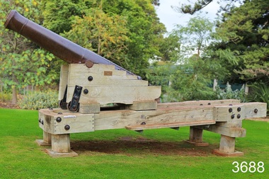 Flagstaff Hill Maritime Museum and Village
Weapon - Cannon, 1813
This 1813 cannon is classified as a carronade, having been made by the Carron Ironworks foundry in Stirling, Scotland in 1813. It is a large calibre, short range, gun mainly used on ships. The carronade model of cannon was first used when introduced into the British Royal Navy in the American War of the Revolution (1775-1883). This cannon was originally a 28pdr, 48cwt, 8ft gun. The date ‘1837’ on the barrel probably indicates the date that the Board of Ordinance accepted the change in size to a 32pdr. It may originally have been a naval gun and the conversion undertaken when it was brought ashore. It is very probably one of the 15 guns that are known to have constituted the defences of Victoria in 1860. This group of 32pdrs was the shorter model of the 4800width and 8ft length cannon and as such are different from the 32pdrs found in NSW. It was originally located on Cannon Hill in Warrnambool when it was the site of the Warrnambool Battery Western Artillery, formed in 1866. It was obsolete by the time of the 1887 fortifications, and was moved from the Warrnambool Fortifications to the Botanic Gardens in 1910, when the Fortifications were declared obsolete. HISTORIC INFORMATION ABOUT THE CANNON IN THE WARRNAMBOOL AREA In the years following the Crimean War (1854-1857J) there was a great concern in the Colony that Imperial Russia would attempt an invasion. Coastal defences in the colony of Victoria were greatly strengthened by the Government as a result. Warrnambool was originally protected by cannons at Cannon Hill, approximately 1 kilometer west of the Flagstaff Hill Fortifications. The cannons included two 1866 guns, both 80 Pound Rifled Muzzle Loaders (RML) purchased by Victoria’s Colonial Government. They were part of a shipment of 26 such guns sent from England in December 1866. They are registered as No. 23 (80cwt-2qr-0lbs) - Gun 1, and No.13 (81cwt-1qr-12lbs) - Gun 2. They were cast at the Royal Gun Factory, Woolwich Arsenal, in 1866 and have a 6.3 inch bore. Both barrels carry the Royal Cypher of Queen Victoria, Insignia of the Royal Engineers, within the Garter and Motto surmounted by the Crown, with the Royal Cypher of Queen Victoria within the Garter (letters in centre “VR”, motto “HONI SOIT QUI MAL Y PENSE”, "Shame be to him who thinks evil of it."). The guns were originally supplied with wooden carriages. (The Royal Arsenal at Woolwich, England, was established eleven years after the Restoration of King Charles II. It was the principal supplier of armaments to the British and Empire Governments. At the height of its operations during World War One the factory covered 1300 acres and employed very nearly 80,000 workers. Woolwich was the Headquarters of the Royal Artillery since the raising of that Regiment in 1716. The Arsenal was closed in the late 1960’s.) The two 80pdr cannons were transferred to the Warrnambool Garrison Artillery Battery Fortifications erected at Flagstaff Hill in 1887 as part of Victoria’s Coastal Defences. The original wooden carriages were subsequently replaced with the present iron garrison carriages in 1888. They are a “C” pivot. The ‘racers’ or curved track set into the floor of the gun emplacement (which enabled the guns to be traversed more quickly) are as specified for guns up to 10 inch, being of wrought iron 2.78 inches wide. A temporary third gun, now no longer on Flagstaff Hill’s site, was a 5 inch Rifled Breech Loading (BL) Armstrong gun mounted on an Elswick hydro pneumatic disappearing carriage It was faster to load and fire than the 80 pound RMLs and its arrival spelt the end of the older 80 pound guns’ useful life, apart from being used for practice sessions. The 5 inch BL gun was the main defensive weapon of the Warrnambool Battery until the Battery was downgraded in importance and the gun was recalled to Melbourne in 1910. The gun emplacement still remains in place set between the 2 80pdr cannon. The State of Victoria took over the ownership of the guns at the time of Australian Federation in 1901. In about 1901/1902 the Garrison Battery was converted to the Warrnambool Battery of the Australian Field Artillery (No 4 Field Battery). It was equipped with 4.7 inch naval guns mounted on field carriages. They were now a mobile unit but continued to use the Warrnambool Garrison area at Flagstaff Hill for practice. When the Fortifications were declared obsolete the two 80 Pounder RML were relocated to Cannon Hill in 1910. On the outbreak of World War 1 the 4.7 inch guns were recalled to Melbourne, and the Battery was disbanded. Most of the personnel probably re-enlisted in the local 4th Australian Light Horse Regiment. The two 80 Pounder RML were moved back to the Fortifications in 1973. They were both fully restored by Army First Year Apprentices at the Ordinance Factory in Bendigo in time for the centenary year of the fortifications in 1987. The guns are capable of firing 80 pound (32.3kg) armour piercing exploding shells 3.65kms out to sea. They were original manned by volunteers before a paid Garrison was established. Now the Guns are again fired by volunteers on Special Event days. Since restoration the Gun Number 1 had been fired on a regular basis but Gun Number 2 hadn’t been fired since the mid 1990’s. In April 2015 Gun Number 2 was serviced in preparation for the firing of both cannons on the ANZAC Centenary commemorations on April 25th 2015. Other guns from the original Cannon Hill location were obsolete by the time the 1887 Warrnambool Garrison Artillery Battery was built. These guns are (1) a 32 Pounder Muzzle Loading Smooth Bore (SB) cast in 1813 at the famous Carron Foundry, number 80837 and now located in the Warrnambool Botanic Gardens. It is now mounted on a replica carriage due to the original carriage being in a fragile condition (the original carriage stored under cover at Flagstaff Hill). (2) a 68 Pounder Muzzle Loading Smooth Bore cast in 1861 at the equally august Low Moor Foundry, number 10310 and now located on the lawn area at the entrance to Flagstaff Hill Maritime Village. It is still mounted on its original wooden garrison carriage. Its wooden slide compressor mechanism is fragile and now kept in Flagstaff Hill’s storage. There are only seven 32 Pounder SB made by Carron and fifteen 68 Pounder SB made at Low Moor known to exist in the State of Victoria Plaque attached to the carriage “This replica carriage was constructed by the Warrnambool Tritan Woodworkers club in conjunction with the generosity of local businesses and the Warrnambool community. The original carriage (circa 1860) was removed for restoration and is now located at Flagstaff Hill Maritime Village. The timber used for the replica carriage is Monterey Cypress, which was an early planting in the gardens. 2010 marked the centenary of the cannon’s relocation in the Warrnambool Botanic Gardens.” (Reference; Victorian Guns and Cannons, South Western Victoria Assessment, May 2008, item W/B/01; Flagstaff Hill Maritime Village datasheets and archives). There are only seven 32 Pounder SB made by Carron known to exist in the State of Victoria and this is one of them. On a world level, this cannon represents a high level of rarity. Further, as it has been modified (bored up) it is representative of the historical process of amending artillery in order to ensure a longer usefulness of each piece despite rapidly advancing artillery technology. The number of surviving carriages with traversing slides in this group in South Western Victoria is unique in Australia and probably in the World. Out of 10 such platforms surviving in Australia, the South Western Victorian group has half. Several survive around the world but probably not in such a large group. The wooden sliding compressor mechanism belonging to this cannon is extremely rare, and the only one in this South Western Victorian group of Guns and Cannons. As a whole, this cannon has undergone very little restoration or modification, giving it a high level of integrity. The City of Warrnambool is one of several custodians of a collection of artillery pieces of heritage significance at a state, national and international level. These pieces are directly related to the defence of south-west Victoria in the 19th century. The care and preservation come under the Heritage Act 1995. (Reference; Victorian Guns and Cannons, South Western Victoria Assessment, May 2008).Cannon, or carronade, 32pdr with wheels. Muzzle loading smooth bore (SB) cannon. Cannon has original wooden Burmese Teak carriage and slide with wrought iron fittings and iron wheels. Manufactured by Carron in Scotland, in 1813. It has been converted from a 28pdr. There is a loop for a rope on the cascabel, which was part of the original casting. Re-bored in 1837. Marks include Serial Number, Royal Cypher of King George III, broad arrow of proofing, and numbers to represent the weight. NOTE: The cannon is displayed in the Warrnambool Botanic Gardens and is mounted on a replica wooden carriage; the original wooden carriage is now stored under cover at Flagstaff Hill Maritime Village. This carriage has 4 wheels on swivel attachments and a central gear that allows the wheels to turn on rails. Pressed into left trunnion “80837 / CARRON / 1813”, cast on barrel“symbol (Royal Cypher of King George III”, “symbol (broad arrow of proofing)” and numbers “45-3-24 / 1837” . Cascable “CV” and marks with gradations from nought to three in quarters on each side, On the carriage the end of one of the main slide members carries the mark “W symbol (broad arrow) D” incised into the timber. Plaque attached to the carriage by the Warrnambool Tritan Woodworkers club, 2010, marking the centenary of the cannon’s relocation in the Warrnambool Botanic Gardens and the addition of the replica carriage. flagstaff hill, warrnambool, shipwrecked coast, flagstaff hill maritime museum, maritime museum, shipwreck coast, flagstaff hill maritime village, great ocean road, victoria’s coastal defences, warrnambool fortification, warrnambool garrison battery, ordinance, armaments, cannon hill fortifications, victorian colonial government, carron ironwroks foundary, 32pdr smooth bore cannon, 28pdr smooth bore cannon, 1813 cannon, carronade -
 Melton City Libraries
Photograph, Martha (Watson) Myers, 1907, c.1930 and 1953
Martha Watson was born on 17 October 1888 in Ballarat, Victoria, Australia as the first child of Robina (Ruby) WATSON. She died on 23 March 1976 in Geelong, Victoria, Australia. Memories of Martha by Valcia nee Twigg Lowrie, granddaughter of Arthur Watson. My memories and recollections as told to me my Grandmother ‘Mum’ Myers. As a child she had scarlet fever and did not attend school during the illness and missed a lot of school (Macarthur Street State School). When she was meant to return to school having fallen behind her classmates, confused and behind with the school work, she instead spent her time wandering around Lake Wendouree feeling too ashamed to attend school. Her uncle Arthur, born in 1874, whom she idealized, was a type of father/mentor figure who played and important part in her early life. He moved to Queensland in the early 1900’s and they did not meet again until he visited Melton in 1949, he died in 1954. He was a champion rower in Victoria and Queensland and a noted cyclist who rode in three Warrnambool to Melbourne races, and footballer. Her mother’s death certificate reveals her place of death as the Ballarat Hospital on 8th September 1903 aged 36. Martha was not told of the death of her mother, it was some time later when she found out her mother had died. She was greatly distressed when she eventually found out. The grief and the circumstance of her mothers death and her unfortunate life had a permanent effect on Martha’s life. Robina was buried in Open Ground at the New Cemetery Ballarat. Marjorie likened to this to the death of Mozart at the age of 35 who was also buried in a common grave. Martha also told me the stories about how as a child she played at the cemetery, taking the oranges placed as offerings on the Chinese graves and being chased away in fright when caught by a Chinese man. Her description left a vivid impression on my mind. The Burnbank street house was just across the road from the cemetery. The pieces of this story I had heard made sense when I visited the location in recent years. Martha’s described how Nanna would sing on the front verandah, and send her off to t get drink for her. This situation might help explain the reason for Martha’s strong aversion to alcohol. As a young girl it had been distressing to her. Nanna was a colourful and theatrical personality and danced with the Duke when he visited Ballarat. She was also known to have stated that she would marry a man who could give her a bucket of gold, possibly around the time after her first husband, Charles death, she had her young boy Edward to bring up. Martha was about 13 years old when Nanna Watson left Ballarat going to Queensland to visit her son Arthur. Martha slept that night afraid and alone in the empty house. The person who was meant to collect her did not come until the next day. She went to work for a family, a woman with children, they took most of the money that Nanna had left with Martha. There was a new baby in the house and the Scottish man in the house behaved suspiciously towards Martha. She was afraid of him and would hide from him under the bed. At this young age she managed to survive on her wits and sense of self preservation. It is not known how long she worked with this family. The place was from my impression, away from the town of Ballarat. Her very difficult formative years are testament to her strength of character and determination to succeed in life and ambition to provide the best opportunities for her own children. In 1905 Martha received a post card from Uncle Arthur in Brisbane addressed – c/o Mrs Styles 14 High Street Ballarat. Dolly Styles was a Ballarat friend and she kept in contact with her for many years. A letter reveals her living in Minyip in her older years. Martha is thought to have spent a few years working before she arrived in Melton. Miss Shebler hired Martha to help her in the care of her father and to assist with work in the Golden Fleece Hotel. Mr Shebler was a nice old man and mostly confined to his room and somewhat childlike as described by Martha. [The elderly Mr August Shebler died in February 1908]. Martha’s exact arrival in Melton is not known, but could be estimated as late 1906 to early 1907. In her room at the hotel she could hear the spring cart of Mr Minns going on the milk delivery rounds in the very early hours of the morning after coming across the creek from his house When she was 19, she married Frederick Thomas MYERS, son of Henri MIERS and Ann DOWLING, on 30 April 1908 ( Fitzroy, Victoria, Australia). Frederick Thomas MYERS and Martha Mary WATSON had the following children: 1. Frederick John Watson MYERS was born on 01 October 1908 in Melton, Victoria, Australia.He died on 07 February 2001.He married Mary June BATTYE on 18 September 1948 in Victoria, Australia. 2. Marjorie Gretchen MYERS was born on 21 February 1912 in Melton, Victoria, Australia.She died on 10 September 2004 in Frankston, Victoria, Australia.She married Herbert Vivian BUTLER on 07 January 1939 in Victoria, Australia. 3. Eva Edna MYERS was born on 15 October 1918 in Melton, Victoria, Australia.She died on 31 January 2008 in Bacchus Marsh, Victoria, Australia.She married Ernest Wesley BARRIE on 25 October 1941 in Melton, Victoria, Australia. 4. Arthur Bruce MYERS was born on 29 April 1925 in Melton, Victoria, Australia.He died on 26 March 2015 in Melbourne, Victoria, Australia.He married Olive Irene NORTON in April 1953 in Balliang, Victoria, Australia (or Church of Christ Footscray? (WB)). 5. Maxwell Douglas MYERS was born on 10 August 1927 in Melton, Victoria, Australia.He died on 03 May 2005 in Geelong, Victoria, Australia.He married Rosemary Rebecca BARRIE on 31 August 1951 in Melton, Victoria, Australia. Valcia nee Twigg Lowrie granddaughter of Arthur Watson, daughter of Mercia and Val Twigg did extensive research on the Marshall family of Lerwick Shetland Isle obtaining birth information of the Scottish forebears. She also got the birth/marriage and death certificates of the Ballarat connection of Robina’s husbands and children. Copies were sent to Edna and Wendy during the early 1990’s. Bruce and Irene also obtained certificates and Myers family information. Wendy applied for certificates at this time.Photographs of Martha (Watson) Myers taken at different times of her life -
 Eltham District Historical Society Inc
Photograph - Aerial Photograph, Landata, Eltham; Crown Allotment 15, Section 5, Parish of Nillumbik (Stokes Orchard Estate), Dec. 1945
Centred on present day Diosma Rd, Stokes Pl, Nyora Rd and Eucalyptus Rd Historic Aerial Imagery Source: Landata.vic.gov.au Aerial Photo Details: Project No :5 Project : MELBOURNE AND METROPOLITAN AREA PROJECT Run : 36 Frame : 60546 Date : 12/1945 Film Type : B/W Camera : EAG4 Flying Height : 10200 Scale : 6000 Film Number : 195 GDA2020 : 37°42'47"S, 145°09'56"E MGA2020 : 338306, 5824438 (55) Melways : 22 C4 (ed. 42) A History of the Development of Crown Allotment 15, Section 5, Parish of Nillumbik – Stokes Orchard Crown Allotment 15, Section 5, Parish of Nillumbik (CA15) is a square allotment of 158 acres or approximately a quarter of a square mile. It lies just beyond the eastern end of Pitt Street, south of Nyora Road to the northern end of Eucalyptus Road and extends east from Eucalyptus Road to Reynolds Road. The topography of CA15 is generally steep, sloping up to a hill near the centre of the land, the ridgeline passing through the properties along the southern side of Diosma Road. Eucalyptus Road is a straight north-south road with its northern end at the north west corner of CA15. Until the end of the 1970s this road was an un-named Government Road and was largely not open to traffic. With residential development in the 1970s the road was constructed, and the council allocated the name obviously in recognition of the predominant species of the local bushland. CA15 was purchased from the Crown by George D’Arley Boursiquot, a prominent Melbourne printer, on 28th October 1852. On November 23, 1922, former Member for Gippsland and Melbourne Real Estate Agent, Hubert Patrick Keogh purchased the allotment then sold it March 13, 1925, to local farmer, Robert David Taylor, a former Shire of Eltham Councillor (1911-1920) and Shire President (1919). Taylor had extensive land holdings stretching west towards Bible Street and Main Road. The Taylor home was situated at the top of the hill in Bible Street at present day 82 Bible Street. At the time of Taylor’s purchase in 1925, CA15 was subdivided into 48 lots that could be described as small rural properties or large residential lots. A typical lot size was one hectare or 2.5 acres. The subdivision created two roads, Nyora Road, and Diosma Road, each following an irregular alignment between Eucalyptus and Reynolds Roads. However, the lots were not sold off separately nor were the roads constructed. The land effectively remained as one parcel for many further years. Robert David Taylor died November 30, 1934, and probate was granted to his son of the same name, Robert David Taylor of Bible Street, Salesman and William McLelland Vance Taylor of 73 Emmeline Street, Northcote, Clerk, with the transfer of the land into their names on July 8, 1935. Frank Stokes worked as a qualified accountant at Kennons leather factory in Burnley, while living at 1 Thomas Street, Mitcham. He suffered from migraines and wanted to return to working the land (he had previously worked on farms and orchards since coming to Australia from England in 1926, both in WA and Vic.). He first travelled to the district by train in July 1942 to find land with the intention to establish an orchard. By chance he met Arthur Bird of Bird Orchard (bounded by Pitt Street, Eucalyptus Road, and Wattle Grove) and they got talking over their common interest. Arthur put Frank up for the night and pointed out the land, 158 acres- part of the Taylor Estate- £900, Crown Allotment 15, Section 5, Parish of Nillumbik (CA15) somewhat diagonally opposite Bird Orchard. Stokes applied through the Riverina Agency to purchase the land who in turn applied for permission from Canberra to sell as there was a new government regulation introduced during the Second World War banning land sales except for immediate production. Stokes obtained a loan on his Mitcham house of £600 @ 5% and paid £450 deposit with quarterly payments of £15 spread over 5 years. Stokes was assisted and advised by Arthur Bird who farmed the neighbouring orchard. In early 1943 Stokes took possession and would catch the train out to Eltham on Fridays after work and began building a hut on the corner of Nyora Road and the Government Road (Eucalyptus Road) for shelter and to lock up tools. He established an orchard on the central western part of the land through the centre of which ran a natural waterway (part of the present-day linear park) and was able to pay a neighbour (Hawkins) to help with clearing and fencing 25 acres, and with a horse and single furrowed plough, planted approximately 2,500 fruit trees - cherries, peaches, plums, almonds, pears, apricots and lemons as well as a few apples and oranges; a massive task. Aerial photographs from the 1940s through to the 1990s clearly show the orchard with most of the larger CA15 site remaining as natural bushland. A huge problem was hares and rabbits eating all the new buds off the tiny trees. As well as laying poison he painted the trees with a mixture of cow manure and lime, often working by moonlight. Procurement of wire and wire netting was difficult because of the war but after much effort he obtained a permit from the Agricultural Department for supplies in March 1944. In February 1945 Stokes applied for a permit to build a “packing shed” as no house building was allowed. It was to be 33 feet x 21 feet and cost £312. It was constructed mostly from second-hand materials, which were hard to obtain, especially iron for roofing. Stokes finished work at Kennons on October 31, 1945, and in March 1946 he sold the family home at Mitcham for £1,230 plus £170 for furniture. On May 15, 1946, title to the CA15 property was issued to Frank Howard Alfred Stokes, Orchardist and Gladys Ethel Stokes, Married Woman, both of Pitt Street, Eltham. The family of five then moved into the very unfinished “packing shed” at Eltham, which was a struggle to weatherproof. Eventually rooms were divided off and lined with hessian bags and whitewashed. Their income was firewood (cut and sold), selling rockery stones and cut Sweet Bursaria. (It was discovered during the 1940s that Sweet Bursaria contained the sunscreen compound Aesculin. The RAAF utilised this compound from Sweet Bursaria during WW2 for pilots and gunners.) The orchard’s first fruit sale was a half-case of Le Vanq peaches in December 1947 for the price of 8 shillings. In 1956 plans for house were drawn and Glen Iris bricks purchased (1956 Olympic Rings variant). The building of the house commenced in 1957 - 12 feet of original packing shed was removed – and was completed in 1959. Water was connected from newly built pressure storage on the property at the end of 1959 and the electricity connection for the first time at 3pm on April 29, 1960. The house remains to present day (somewhat modified) at 1 Nyora Road, home to Nyora Studio Gallery. On occasions, spare remnants of the 1956 bricks have been known to be unearthed in gardens on the estate as they were utilised by Frank Stokes to fill in rabbit holes. On May 26, 1950, a parcel of land was compulsorily acquired by the Melbourne and Metropolitan Board of Works on the hilltop to establish an easement for a high-level service reservoir to augment Eltham’s water supply. The project also included pipe tracks for the necessary water mains. The reservoir has now been superseded by higher level water tanks east of Reynolds Road and its former site is now a public reserve. On November 27, 1964, the State Electricity Commission served notice to compulsorily acquire a further parcel through the eastern part of the land for a major electricity transmission line that augmented supply from the La Trobe Valley to Melbourne. The easement was registered February 11, 1966. The easement was widened July 18, 1969 for a second transmission line to be constructed. In 1971 Melbourne Metropolitan Planning Scheme amendments adopted Nyora Road as the boundary between a residential zone to the north and a rural zone to the south. This determined the future development of the land. In the mid-1970s the Shire of Eltham divided the orchard into numerous rate-able parcel lots, the 48 lots having been established in 1925 and the subsequent rates assessment proved unsustainable for Stokes. He commenced selling lots outside the boundary of the orchard, north of Diosma and South of Nyora. However shortly later the land between Nyora and Diosma Roads and west of the electricity easement was sold and subdivided into residential lots, a housing development by Macquarie Builders and marketed as the Stokes Orchard Estate. New streets were created, and most were named after trees, although one, Stokes Place, commemorates the former owners. The development was undertaken in two stages; Stage 1 (1975) encompassing Scarlet Ash Court, Ironbark Close and Peppermint Grove bounded by Nyora and Eucalyptus roads and Stage 2 (1978) encompassing Stokes Place, Orchard Way, The Crest and The Lookout bound by Nyora and Diosma roads. The developer, Macquarie Builders went bankrupt shortly after the release of Stage 2 leaving many purchasers to fend for themselves and arrange for their own independent builders. There were also difficulties with sewerage for the land immediately south of Diosma Road and so the conventional residential lots were abandoned in favour of larger lots. The development of Orchard Way, The Crest and The Lookout did not proceed as planned and the proposed lots were incorporated into five-acre parcels instead. These included a low-density group housing development by the Graves family and the award winning Choong House (1983) with Gordon Ford developed garden immediately next door situated on the ridge of the hill nestled amongst the original bush, Eucalypt trees and Sweet Bursaria. In 1994, Nillumbik Shire Council applied Significant Environment and Significant Landscape overlays upon the properties on the south side of Diosma Road to ensure protection of this natural bush garden environment. With the arrival of the sewer along Diosma Road in the 1990s, most of these five-acre parcels have since been subdivided multiple times. The Choong house presently sits on a 2.7-acre property, which in 2022 Nillumbik Council nominated for Cultural Significance Heritage protection and is considered potentially significant at State level. The Stokes family were also associated with the Eltham Christian Church. In the 1970s this church had met in temporary premises in Eltham. Lots of the original 1925 subdivision remained south of Nyora Road and a number of these lots were utilized for the Eltham Christian School, which was established by the Eltham Christian Church in 1981. The school operated on this site until 2000. The premises are now used by The Vine Baptist Church. By the mid-1980s the whole of CA15 had been developed for residential and school purposes, except for the sections north of Diosma Road and between the transmission lines and Reynolds Road. Sewerage issues had been resolved for the section north of Diosma Road and in 1987 it was in the process of being subdivided into residential lots. The development coincided with the discovery of colonies of the rare and endangered Eltham Copper Butterfly on the site. This resulted in a community and political campaign to save the butterfly habitat. With the co-operation of the land developer the subdivision was altered to create two bushland reserves in the critical butterfly habitat areas. In the late 1980s the State Government was investigating options for establishing a metropolitan ring road link between Diamond Creek and Ringwood. The chosen route was adjacent to Reynolds Road and so this created a freeze on development of CA15 between Reynolds Road and the electricity easement. The ring road proposal was eventually abandoned, and this part of the land was subdivided into low density residential lots. Diosma Road has been discontinued at the electricity easement and the eastern part incorporated into View Mount Court with access from Reynolds Road. The whole of CA15 has now been developed for residential or associated purposes, ranging from conventional density to quite low density south of Nyora Road. Some remnants of the orchard remain, a few cherry trees on the Graves property and a lone apple tree in Stokes Place. The butterfly reserves comprise significant areas of remnant bushland. Linear reserves through the estate link with central Eltham via the Woodridge linear reserve and with Research along the electricity easement. CA15 as it exists today has a complicated history of rural use, Government acquisition, urban development, and community action. References: • “Stokes Orchard, an incomplete history”; Russell Yeoman with Doug Orford • Correspondence, Beryl Bradbury (nee Stokes) • Aerial Photographs, 1931-1991, Landata (landata.vic.gov.au) • Certificate of Title, Vol. 4930 Fol. 985900 • Plan Number LP 10859 aerial photo, diosma road, eltham copper butterfly, eucalyptus road, ironbark close, nyora road, peppermint grove, peter & elizabeth pidgeon collection, power transmission lines, reynolds road, scarlet ash court, stokes orchard estate, stokes place, woodridge estate, frank stokes -
 Eltham District Historical Society Inc
Photograph - Aerial Photograph, Landata, Eltham; Crown Allotment 15, Section 5, Parish of Nillumbik (Stokes Orchard Estate), Nov. 1931
Centred over present day Reynolds Road and Mount Pleasant Road, Eltham (including Diosma Rd, Stokes Pl, Nyora Rd and Eucalyptus Rd) Historic Aerial Imagery Source: Landata.vic.gov.au Aerial Photo Details: Project No :1931 Project : MALDON PRISON Run : 21 Frame : 3160 Date : 11/1931 Film Type : B/W Camera : F8 Flying Height : 11000 Scale : 18860 Film Number : 60 GDA2020 : 37°43'31"S, 145°10'20"E MGA2020 : 338912, 5823086 (55) Melways : 22 E8 (ed. 42) A History of the Development of Crown Allotment 15, Section 5, Parish of Nillumbik – Stokes Orchard Crown Allotment 15, Section 5, Parish of Nillumbik (CA15) is a square allotment of 158 acres or approximately a quarter of a square mile. It lies just beyond the eastern end of Pitt Street, south of Nyora Road to the northern end of Eucalyptus Road and extends east from Eucalyptus Road to Reynolds Road. The topography of CA15 is generally steep, sloping up to a hill near the centre of the land, the ridgeline passing through the properties along the southern side of Diosma Road. Eucalyptus Road is a straight north-south road with its northern end at the north west corner of CA15. Until the end of the 1970s this road was an un-named Government Road and was largely not open to traffic. With residential development in the 1970s the road was constructed, and the council allocated the name obviously in recognition of the predominant species of the local bushland. CA15 was purchased from the Crown by George D’Arley Boursiquot, a prominent Melbourne printer, on 28th October 1852. On November 23, 1922, former Member for Gippsland and Melbourne Real Estate Agent, Hubert Patrick Keogh purchased the allotment then sold it March 13, 1925, to local farmer, Robert David Taylor, a former Shire of Eltham Councillor (1911-1920) and Shire President (1919). Taylor had extensive land holdings stretching west towards Bible Street and Main Road. The Taylor home was situated at the top of the hill in Bible Street at present day 82 Bible Street. At the time of Taylor’s purchase in 1925, CA15 was subdivided into 48 lots that could be described as small rural properties or large residential lots. A typical lot size was one hectare or 2.5 acres. The subdivision created two roads, Nyora Road, and Diosma Road, each following an irregular alignment between Eucalyptus and Reynolds Roads. However, the lots were not sold off separately nor were the roads constructed. The land effectively remained as one parcel for many further years. Robert David Taylor died November 30, 1934, and probate was granted to his son of the same name, Robert David Taylor of Bible Street, Salesman and William McLelland Vance Taylor of 73 Emmeline Street, Northcote, Clerk, with the transfer of the land into their names on July 8, 1935. Frank Stokes worked as a qualified accountant at Kennons leather factory in Burnley, while living at 1 Thomas Street, Mitcham. He suffered from migraines and wanted to return to working the land (he had previously worked on farms and orchards since coming to Australia from England in 1926, both in WA and Vic.). He first travelled to the district by train in July 1942 to find land with the intention to establish an orchard. By chance he met Arthur Bird of Bird Orchard (bounded by Pitt Street, Eucalyptus Road, and Wattle Grove) and they got talking over their common interest. Arthur put Frank up for the night and pointed out the land, 158 acres- part of the Taylor Estate- £900, Crown Allotment 15, Section 5, Parish of Nillumbik (CA15) somewhat diagonally opposite Bird Orchard. Stokes applied through the Riverina Agency to purchase the land who in turn applied for permission from Canberra to sell as there was a new government regulation introduced during the Second World War banning land sales except for immediate production. Stokes obtained a loan on his Mitcham house of £600 @ 5% and paid £450 deposit with quarterly payments of £15 spread over 5 years. Stokes was assisted and advised by Arthur Bird who farmed the neighbouring orchard. In early 1943 Stokes took possession and would catch the train out to Eltham on Fridays after work and began building a hut on the corner of Nyora Road and the Government Road (Eucalyptus Road) for shelter and to lock up tools. He established an orchard on the central western part of the land through the centre of which ran a natural waterway (part of the present-day linear park) and was able to pay a neighbour (Hawkins) to help with clearing and fencing 25 acres, and with a horse and single furrowed plough, planted approximately 2,500 fruit trees - cherries, peaches, plums, almonds, pears, apricots and lemons as well as a few apples and oranges; a massive task. Aerial photographs from the 1940s through to the 1990s clearly show the orchard with most of the larger CA15 site remaining as natural bushland. A huge problem was hares and rabbits eating all the new buds off the tiny trees. As well as laying poison he painted the trees with a mixture of cow manure and lime, often working by moonlight. Procurement of wire and wire netting was difficult because of the war but after much effort he obtained a permit from the Agricultural Department for supplies in March 1944. In February 1945 Stokes applied for a permit to build a “packing shed” as no house building was allowed. It was to be 33 feet x 21 feet and cost £312. It was constructed mostly from second-hand materials, which were hard to obtain, especially iron for roofing. Stokes finished work at Kennons on October 31, 1945, and in March 1946 he sold the family home at Mitcham for £1,230 plus £170 for furniture. On May 15, 1946, title to the CA15 property was issued to Frank Howard Alfred Stokes, Orchardist and Gladys Ethel Stokes, Married Woman, both of Pitt Street, Eltham. The family of five then moved into the very unfinished “packing shed” at Eltham, which was a struggle to weatherproof. Eventually rooms were divided off and lined with hessian bags and whitewashed. Their income was firewood (cut and sold), selling rockery stones and cut Sweet Bursaria. (It was discovered during the 1940s that Sweet Bursaria contained the sunscreen compound Aesculin. The RAAF utilised this compound from Sweet Bursaria during WW2 for pilots and gunners.) The orchard’s first fruit sale was a half-case of Le Vanq peaches in December 1947 for the price of 8 shillings. In 1956 plans for house were drawn and Glen Iris bricks purchased (1956 Olympic Rings variant). The building of the house commenced in 1957 - 12 feet of original packing shed was removed – and was completed in 1959. Water was connected from newly built pressure storage on the property at the end of 1959 and the electricity connection for the first time at 3pm on April 29, 1960. The house remains to present day (somewhat modified) at 1 Nyora Road, home to Nyora Studio Gallery. On occasions, spare remnants of the 1956 bricks have been known to be unearthed in gardens on the estate as they were utilised by Frank Stokes to fill in rabbit holes. On May 26, 1950, a parcel of land was compulsorily acquired by the Melbourne and Metropolitan Board of Works on the hilltop to establish an easement for a high-level service reservoir to augment Eltham’s water supply. The project also included pipe tracks for the necessary water mains. The reservoir has now been superseded by higher level water tanks east of Reynolds Road and its former site is now a public reserve. On November 27, 1964, the State Electricity Commission served notice to compulsorily acquire a further parcel through the eastern part of the land for a major electricity transmission line that augmented supply from the La Trobe Valley to Melbourne. The easement was registered February 11, 1966. The easement was widened July 18, 1969 for a second transmission line to be constructed. In 1971 Melbourne Metropolitan Planning Scheme amendments adopted Nyora Road as the boundary between a residential zone to the north and a rural zone to the south. This determined the future development of the land. In the mid-1970s the Shire of Eltham divided the orchard into numerous rate-able parcel lots, the 48 lots having been established in 1925 and the subsequent rates assessment proved unsustainable for Stokes. He commenced selling lots outside the boundary of the orchard, north of Diosma and South of Nyora. However shortly later the land between Nyora and Diosma Roads and west of the electricity easement was sold and subdivided into residential lots, a housing development by Macquarie Builders and marketed as the Stokes Orchard Estate. New streets were created, and most were named after trees, although one, Stokes Place, commemorates the former owners. The development was undertaken in two stages; Stage 1 (1975) encompassing Scarlet Ash Court, Ironbark Close and Peppermint Grove bounded by Nyora and Eucalyptus roads and Stage 2 (1978) encompassing Stokes Place, Orchard Way, The Crest and The Lookout bound by Nyora and Diosma roads. The developer, Macquarie Builders went bankrupt shortly after the release of Stage 2 leaving many purchasers to fend for themselves and arrange for their own independent builders. There were also difficulties with sewerage for the land immediately south of Diosma Road and so the conventional residential lots were abandoned in favour of larger lots. The development of Orchard Way, The Crest and The Lookout did not proceed as planned and the proposed lots were incorporated into five-acre parcels instead. These included a low-density group housing development by the Graves family and the award winning Choong House (1983) with Gordon Ford developed garden immediately next door situated on the ridge of the hill nestled amongst the original bush, Eucalypt trees and Sweet Bursaria. In 1994, Nillumbik Shire Council applied Significant Environment and Significant Landscape overlays upon the properties on the south side of Diosma Road to ensure protection of this natural bush garden environment. With the arrival of the sewer along Diosma Road in the 1990s, most of these five-acre parcels have since been subdivided multiple times. The Choong house presently sits on a 2.7-acre property, which in 2022 Nillumbik Council nominated for Cultural Significance Heritage protection and is considered potentially significant at State level. The Stokes family were also associated with the Eltham Christian Church. In the 1970s this church had met in temporary premises in Eltham. Lots of the original 1925 subdivision remained south of Nyora Road and a number of these lots were utilized for the Eltham Christian School, which was established by the Eltham Christian Church in 1981. The school operated on this site until 2000. The premises are now used by The Vine Baptist Church. By the mid-1980s the whole of CA15 had been developed for residential and school purposes, except for the sections north of Diosma Road and between the transmission lines and Reynolds Road. Sewerage issues had been resolved for the section north of Diosma Road and in 1987 it was in the process of being subdivided into residential lots. The development coincided with the discovery of colonies of the rare and endangered Eltham Copper Butterfly on the site. This resulted in a community and political campaign to save the butterfly habitat. With the co-operation of the land developer the subdivision was altered to create two bushland reserves in the critical butterfly habitat areas. In the late 1980s the State Government was investigating options for establishing a metropolitan ring road link between Diamond Creek and Ringwood. The chosen route was adjacent to Reynolds Road and so this created a freeze on development of CA15 between Reynolds Road and the electricity easement. The ring road proposal was eventually abandoned, and this part of the land was subdivided into low density residential lots. Diosma Road has been discontinued at the electricity easement and the eastern part incorporated into View Mount Court with access from Reynolds Road. The whole of CA15 has now been developed for residential or associated purposes, ranging from conventional density to quite low density south of Nyora Road. Some remnants of the orchard remain, a few cherry trees on the Graves property and a lone apple tree in Stokes Place. The butterfly reserves comprise significant areas of remnant bushland. Linear reserves through the estate link with central Eltham via the Woodridge linear reserve and with Research along the electricity easement. CA15 as it exists today has a complicated history of rural use, Government acquisition, urban development, and community action. References: • “Stokes Orchard, an incomplete history”; Russell Yeoman with Doug Orford • Correspondence, Beryl Bradbury (nee Stokes) • Aerial Photographs, 1931-1991, Landata (landata.vic.gov.au) • Certificate of Title, Vol. 4930 Fol. 985900 • Plan Number LP 10859 aerial photo, diosma road, eltham copper butterfly, eucalyptus road, ironbark close, nyora road, peppermint grove, peter & elizabeth pidgeon collection, power transmission lines, reynolds road, scarlet ash court, stokes orchard estate, stokes place, woodridge estate, frank stokes -
 Eltham District Historical Society Inc
Photograph - Aerial Photograph, Landata, Eltham; Crown Allotment 15, Section 5, Parish of Nillumbik (Stokes Orchard Estate), Jan. 1951
Centred on present day Diosma Rd, Stokes Pl, Nyora Rd and Eucalyptus Rd Historic Aerial Imagery Source: Landata.vic.gov.au Aerial Photo Details: Project No :65 Project : MELBOURNE AND METROPOLITAN PROJECT NO. 2 Run : 8 Frame : 71 Date : 01/1951 Film Type : B/W Camera : EAG9 Flying Height : 12200 Scale : 12000 Film Number : 1419 GDA2020 : 37°43'14"S, 145°09'46"E MGA2020 : 338081, 5823608 (55) Melways : 22 C6 (ed. 42) A History of the Development of Crown Allotment 15, Section 5, Parish of Nillumbik – Stokes Orchard Crown Allotment 15, Section 5, Parish of Nillumbik (CA15) is a square allotment of 158 acres or approximately a quarter of a square mile. It lies just beyond the eastern end of Pitt Street, south of Nyora Road to the northern end of Eucalyptus Road and extends east from Eucalyptus Road to Reynolds Road. The topography of CA15 is generally steep, sloping up to a hill near the centre of the land, the ridgeline passing through the properties along the southern side of Diosma Road. Eucalyptus Road is a straight north-south road with its northern end at the north west corner of CA15. Until the end of the 1970s this road was an un-named Government Road and was largely not open to traffic. With residential development in the 1970s the road was constructed, and the council allocated the name obviously in recognition of the predominant species of the local bushland. CA15 was purchased from the Crown by George D’Arley Boursiquot, a prominent Melbourne printer, on 28th October 1852. On November 23, 1922, former Member for Gippsland and Melbourne Real Estate Agent, Hubert Patrick Keogh purchased the allotment then sold it March 13, 1925, to local farmer, Robert David Taylor, a former Shire of Eltham Councillor (1911-1920) and Shire President (1919). Taylor had extensive land holdings stretching west towards Bible Street and Main Road. The Taylor home was situated at the top of the hill in Bible Street at present day 82 Bible Street. At the time of Taylor’s purchase in 1925, CA15 was subdivided into 48 lots that could be described as small rural properties or large residential lots. A typical lot size was one hectare or 2.5 acres. The subdivision created two roads, Nyora Road, and Diosma Road, each following an irregular alignment between Eucalyptus and Reynolds Roads. However, the lots were not sold off separately nor were the roads constructed. The land effectively remained as one parcel for many further years. Robert David Taylor died November 30, 1934, and probate was granted to his son of the same name, Robert David Taylor of Bible Street, Salesman and William McLelland Vance Taylor of 73 Emmeline Street, Northcote, Clerk, with the transfer of the land into their names on July 8, 1935. Frank Stokes worked as a qualified accountant at Kennons leather factory in Burnley, while living at 1 Thomas Street, Mitcham. He suffered from migraines and wanted to return to working the land (he had previously worked on farms and orchards since coming to Australia from England in 1926, both in WA and Vic.). He first travelled to the district by train in July 1942 to find land with the intention to establish an orchard. By chance he met Arthur Bird of Bird Orchard (bounded by Pitt Street, Eucalyptus Road, and Wattle Grove) and they got talking over their common interest. Arthur put Frank up for the night and pointed out the land, 158 acres- part of the Taylor Estate- £900, Crown Allotment 15, Section 5, Parish of Nillumbik (CA15) somewhat diagonally opposite Bird Orchard. Stokes applied through the Riverina Agency to purchase the land who in turn applied for permission from Canberra to sell as there was a new government regulation introduced during the Second World War banning land sales except for immediate production. Stokes obtained a loan on his Mitcham house of £600 @ 5% and paid £450 deposit with quarterly payments of £15 spread over 5 years. Stokes was assisted and advised by Arthur Bird who farmed the neighbouring orchard. In early 1943 Stokes took possession and would catch the train out to Eltham on Fridays after work and began building a hut on the corner of Nyora Road and the Government Road (Eucalyptus Road) for shelter and to lock up tools. He established an orchard on the central western part of the land through the centre of which ran a natural waterway (part of the present-day linear park) and was able to pay a neighbour (Hawkins) to help with clearing and fencing 25 acres, and with a horse and single furrowed plough, planted approximately 2,500 fruit trees - cherries, peaches, plums, almonds, pears, apricots and lemons as well as a few apples and oranges; a massive task. Aerial photographs from the 1940s through to the 1990s clearly show the orchard with most of the larger CA15 site remaining as natural bushland. A huge problem was hares and rabbits eating all the new buds off the tiny trees. As well as laying poison he painted the trees with a mixture of cow manure and lime, often working by moonlight. Procurement of wire and wire netting was difficult because of the war but after much effort he obtained a permit from the Agricultural Department for supplies in March 1944. In February 1945 Stokes applied for a permit to build a “packing shed” as no house building was allowed. It was to be 33 feet x 21 feet and cost £312. It was constructed mostly from second-hand materials, which were hard to obtain, especially iron for roofing. Stokes finished work at Kennons on October 31, 1945, and in March 1946 he sold the family home at Mitcham for £1,230 plus £170 for furniture. On May 15, 1946, title to the CA15 property was issued to Frank Howard Alfred Stokes, Orchardist and Gladys Ethel Stokes, Married Woman, both of Pitt Street, Eltham. The family of five then moved into the very unfinished “packing shed” at Eltham, which was a struggle to weatherproof. Eventually rooms were divided off and lined with hessian bags and whitewashed. Their income was firewood (cut and sold), selling rockery stones and cut Sweet Bursaria. (It was discovered during the 1940s that Sweet Bursaria contained the sunscreen compound Aesculin. The RAAF utilised this compound from Sweet Bursaria during WW2 for pilots and gunners.) The orchard’s first fruit sale was a half-case of Le Vanq peaches in December 1947 for the price of 8 shillings. In 1956 plans for house were drawn and Glen Iris bricks purchased (1956 Olympic Rings variant). The building of the house commenced in 1957 - 12 feet of original packing shed was removed – and was completed in 1959. Water was connected from newly built pressure storage on the property at the end of 1959 and the electricity connection for the first time at 3pm on April 29, 1960. The house remains to present day (somewhat modified) at 1 Nyora Road, home to Nyora Studio Gallery. On occasions, spare remnants of the 1956 bricks have been known to be unearthed in gardens on the estate as they were utilised by Frank Stokes to fill in rabbit holes. On May 26, 1950, a parcel of land was compulsorily acquired by the Melbourne and Metropolitan Board of Works on the hilltop to establish an easement for a high-level service reservoir to augment Eltham’s water supply. The project also included pipe tracks for the necessary water mains. The reservoir has now been superseded by higher level water tanks east of Reynolds Road and its former site is now a public reserve. On November 27, 1964, the State Electricity Commission served notice to compulsorily acquire a further parcel through the eastern part of the land for a major electricity transmission line that augmented supply from the La Trobe Valley to Melbourne. The easement was registered February 11, 1966. The easement was widened July 18, 1969 for a second transmission line to be constructed. In 1971 Melbourne Metropolitan Planning Scheme amendments adopted Nyora Road as the boundary between a residential zone to the north and a rural zone to the south. This determined the future development of the land. In the mid-1970s the Shire of Eltham divided the orchard into numerous rate-able parcel lots, the 48 lots having been established in 1925 and the subsequent rates assessment proved unsustainable for Stokes. He commenced selling lots outside the boundary of the orchard, north of Diosma and South of Nyora. However shortly later the land between Nyora and Diosma Roads and west of the electricity easement was sold and subdivided into residential lots, a housing development by Macquarie Builders and marketed as the Stokes Orchard Estate. New streets were created, and most were named after trees, although one, Stokes Place, commemorates the former owners. The development was undertaken in two stages; Stage 1 (1975) encompassing Scarlet Ash Court, Ironbark Close and Peppermint Grove bounded by Nyora and Eucalyptus roads and Stage 2 (1978) encompassing Stokes Place, Orchard Way, The Crest and The Lookout bound by Nyora and Diosma roads. The developer, Macquarie Builders went bankrupt shortly after the release of Stage 2 leaving many purchasers to fend for themselves and arrange for their own independent builders. There were also difficulties with sewerage for the land immediately south of Diosma Road and so the conventional residential lots were abandoned in favour of larger lots. The development of Orchard Way, The Crest and The Lookout did not proceed as planned and the proposed lots were incorporated into five-acre parcels instead. These included a low-density group housing development by the Graves family and the award winning Choong House (1983) with Gordon Ford developed garden immediately next door situated on the ridge of the hill nestled amongst the original bush, Eucalypt trees and Sweet Bursaria. In 1994, Nillumbik Shire Council applied Significant Environment and Significant Landscape overlays upon the properties on the south side of Diosma Road to ensure protection of this natural bush garden environment. With the arrival of the sewer along Diosma Road in the 1990s, most of these five-acre parcels have since been subdivided multiple times. The Choong house presently sits on a 2.7-acre property, which in 2022 Nillumbik Council nominated for Cultural Significance Heritage protection and is considered potentially significant at State level. The Stokes family were also associated with the Eltham Christian Church. In the 1970s this church had met in temporary premises in Eltham. Lots of the original 1925 subdivision remained south of Nyora Road and a number of these lots were utilized for the Eltham Christian School, which was established by the Eltham Christian Church in 1981. The school operated on this site until 2000. The premises are now used by The Vine Baptist Church. By the mid-1980s the whole of CA15 had been developed for residential and school purposes, except for the sections north of Diosma Road and between the transmission lines and Reynolds Road. Sewerage issues had been resolved for the section north of Diosma Road and in 1987 it was in the process of being subdivided into residential lots. The development coincided with the discovery of colonies of the rare and endangered Eltham Copper Butterfly on the site. This resulted in a community and political campaign to save the butterfly habitat. With the co-operation of the land developer the subdivision was altered to create two bushland reserves in the critical butterfly habitat areas. In the late 1980s the State Government was investigating options for establishing a metropolitan ring road link between Diamond Creek and Ringwood. The chosen route was adjacent to Reynolds Road and so this created a freeze on development of CA15 between Reynolds Road and the electricity easement. The ring road proposal was eventually abandoned, and this part of the land was subdivided into low density residential lots. Diosma Road has been discontinued at the electricity easement and the eastern part incorporated into View Mount Court with access from Reynolds Road. The whole of CA15 has now been developed for residential or associated purposes, ranging from conventional density to quite low density south of Nyora Road. Some remnants of the orchard remain, a few cherry trees on the Graves property and a lone apple tree in Stokes Place. The butterfly reserves comprise significant areas of remnant bushland. Linear reserves through the estate link with central Eltham via the Woodridge linear reserve and with Research along the electricity easement. CA15 as it exists today has a complicated history of rural use, Government acquisition, urban development, and community action. References: • “Stokes Orchard, an incomplete history”; Russell Yeoman with Doug Orford • Correspondence, Beryl Bradbury (nee Stokes) • Aerial Photographs, 1931-1991, Landata (landata.vic.gov.au) • Certificate of Title, Vol. 4930 Fol. 985900 • Plan Number LP 10859 aerial photo, diosma road, eltham copper butterfly, eucalyptus road, ironbark close, nyora road, peppermint grove, peter & elizabeth pidgeon collection, power transmission lines, reynolds road, scarlet ash court, stokes orchard estate, stokes place, woodridge estate, frank stokes -
 Eltham District Historical Society Inc
Photograph - Aerial Photograph, Landata, Eltham; Crown Allotment 15, Section 5, Parish of Nillumbik (Stokes Orchard Estate), Feb. 1956
Centred on present day Diosma Rd, Stokes Pl, Nyora Rd and Eucalyptus Rd Historic Aerial Imagery Source: Landata.vic.gov.au Aerial Photo Details: Project No :250 Project : MELBOURNE OUTER SUBURBS PROJECT Run : 18 Frame : 94 Date : 02/1956 Film Type : B/W Camera : EAG9 Flying Height : 10000 Scale : 12000 Film Number : 1176 GDA2020 : 37°42'30"S, 145°09'44"E MGA2020 : 338008, 5824963 (55) Melways : 22 C3 (ed. 42) A History of the Development of Crown Allotment 15, Section 5, Parish of Nillumbik – Stokes Orchard Crown Allotment 15, Section 5, Parish of Nillumbik (CA15) is a square allotment of 158 acres or approximately a quarter of a square mile. It lies just beyond the eastern end of Pitt Street, south of Nyora Road to the northern end of Eucalyptus Road and extends east from Eucalyptus Road to Reynolds Road. The topography of CA15 is generally steep, sloping up to a hill near the centre of the land, the ridgeline passing through the properties along the southern side of Diosma Road. Eucalyptus Road is a straight north-south road with its northern end at the north west corner of CA15. Until the end of the 1970s this road was an un-named Government Road and was largely not open to traffic. With residential development in the 1970s the road was constructed, and the council allocated the name obviously in recognition of the predominant species of the local bushland. CA15 was purchased from the Crown by George D’Arley Boursiquot, a prominent Melbourne printer, on 28th October 1852. On November 23, 1922, former Member for Gippsland and Melbourne Real Estate Agent, Hubert Patrick Keogh purchased the allotment then sold it March 13, 1925, to local farmer, Robert David Taylor, a former Shire of Eltham Councillor (1911-1920) and Shire President (1919). Taylor had extensive land holdings stretching west towards Bible Street and Main Road. The Taylor home was situated at the top of the hill in Bible Street at present day 82 Bible Street. At the time of Taylor’s purchase in 1925, CA15 was subdivided into 48 lots that could be described as small rural properties or large residential lots. A typical lot size was one hectare or 2.5 acres. The subdivision created two roads, Nyora Road, and Diosma Road, each following an irregular alignment between Eucalyptus and Reynolds Roads. However, the lots were not sold off separately nor were the roads constructed. The land effectively remained as one parcel for many further years. Robert David Taylor died November 30, 1934, and probate was granted to his son of the same name, Robert David Taylor of Bible Street, Salesman and William McLelland Vance Taylor of 73 Emmeline Street, Northcote, Clerk, with the transfer of the land into their names on July 8, 1935. Frank Stokes worked as a qualified accountant at Kennons leather factory in Burnley, while living at 1 Thomas Street, Mitcham. He suffered from migraines and wanted to return to working the land (he had previously worked on farms and orchards since coming to Australia from England in 1926, both in WA and Vic.). He first travelled to the district by train in July 1942 to find land with the intention to establish an orchard. By chance he met Arthur Bird of Bird Orchard (bounded by Pitt Street, Eucalyptus Road, and Wattle Grove) and they got talking over their common interest. Arthur put Frank up for the night and pointed out the land, 158 acres- part of the Taylor Estate- £900, Crown Allotment 15, Section 5, Parish of Nillumbik (CA15) somewhat diagonally opposite Bird Orchard. Stokes applied through the Riverina Agency to purchase the land who in turn applied for permission from Canberra to sell as there was a new government regulation introduced during the Second World War banning land sales except for immediate production. Stokes obtained a loan on his Mitcham house of £600 @ 5% and paid £450 deposit with quarterly payments of £15 spread over 5 years. Stokes was assisted and advised by Arthur Bird who farmed the neighbouring orchard. In early 1943 Stokes took possession and would catch the train out to Eltham on Fridays after work and began building a hut on the corner of Nyora Road and the Government Road (Eucalyptus Road) for shelter and to lock up tools. He established an orchard on the central western part of the land through the centre of which ran a natural waterway (part of the present-day linear park) and was able to pay a neighbour (Hawkins) to help with clearing and fencing 25 acres, and with a horse and single furrowed plough, planted approximately 2,500 fruit trees - cherries, peaches, plums, almonds, pears, apricots and lemons as well as a few apples and oranges; a massive task. Aerial photographs from the 1940s through to the 1990s clearly show the orchard with most of the larger CA15 site remaining as natural bushland. A huge problem was hares and rabbits eating all the new buds off the tiny trees. As well as laying poison he painted the trees with a mixture of cow manure and lime, often working by moonlight. Procurement of wire and wire netting was difficult because of the war but after much effort he obtained a permit from the Agricultural Department for supplies in March 1944. In February 1945 Stokes applied for a permit to build a “packing shed” as no house building was allowed. It was to be 33 feet x 21 feet and cost £312. It was constructed mostly from second-hand materials, which were hard to obtain, especially iron for roofing. Stokes finished work at Kennons on October 31, 1945, and in March 1946 he sold the family home at Mitcham for £1,230 plus £170 for furniture. On May 15, 1946, title to the CA15 property was issued to Frank Howard Alfred Stokes, Orchardist and Gladys Ethel Stokes, Married Woman, both of Pitt Street, Eltham. The family of five then moved into the very unfinished “packing shed” at Eltham, which was a struggle to weatherproof. Eventually rooms were divided off and lined with hessian bags and whitewashed. Their income was firewood (cut and sold), selling rockery stones and cut Sweet Bursaria. (It was discovered during the 1940s that Sweet Bursaria contained the sunscreen compound Aesculin. The RAAF utilised this compound from Sweet Bursaria during WW2 for pilots and gunners.) The orchard’s first fruit sale was a half-case of Le Vanq peaches in December 1947 for the price of 8 shillings. In 1956 plans for house were drawn and Glen Iris bricks purchased (1956 Olympic Rings variant). The building of the house commenced in 1957 - 12 feet of original packing shed was removed – and was completed in 1959. Water was connected from newly built pressure storage on the property at the end of 1959 and the electricity connection for the first time at 3pm on April 29, 1960. The house remains to present day (somewhat modified) at 1 Nyora Road, home to Nyora Studio Gallery. On occasions, spare remnants of the 1956 bricks have been known to be unearthed in gardens on the estate as they were utilised by Frank Stokes to fill in rabbit holes. On May 26, 1950, a parcel of land was compulsorily acquired by the Melbourne and Metropolitan Board of Works on the hilltop to establish an easement for a high-level service reservoir to augment Eltham’s water supply. The project also included pipe tracks for the necessary water mains. The reservoir has now been superseded by higher level water tanks east of Reynolds Road and its former site is now a public reserve. On November 27, 1964, the State Electricity Commission served notice to compulsorily acquire a further parcel through the eastern part of the land for a major electricity transmission line that augmented supply from the La Trobe Valley to Melbourne. The easement was registered February 11, 1966. The easement was widened July 18, 1969 for a second transmission line to be constructed. In 1971 Melbourne Metropolitan Planning Scheme amendments adopted Nyora Road as the boundary between a residential zone to the north and a rural zone to the south. This determined the future development of the land. In the mid-1970s the Shire of Eltham divided the orchard into numerous rate-able parcel lots, the 48 lots having been established in 1925 and the subsequent rates assessment proved unsustainable for Stokes. He commenced selling lots outside the boundary of the orchard, north of Diosma and South of Nyora. However shortly later the land between Nyora and Diosma Roads and west of the electricity easement was sold and subdivided into residential lots, a housing development by Macquarie Builders and marketed as the Stokes Orchard Estate. New streets were created, and most were named after trees, although one, Stokes Place, commemorates the former owners. The development was undertaken in two stages; Stage 1 (1975) encompassing Scarlet Ash Court, Ironbark Close and Peppermint Grove bounded by Nyora and Eucalyptus roads and Stage 2 (1978) encompassing Stokes Place, Orchard Way, The Crest and The Lookout bound by Nyora and Diosma roads. The developer, Macquarie Builders went bankrupt shortly after the release of Stage 2 leaving many purchasers to fend for themselves and arrange for their own independent builders. There were also difficulties with sewerage for the land immediately south of Diosma Road and so the conventional residential lots were abandoned in favour of larger lots. The development of Orchard Way, The Crest and The Lookout did not proceed as planned and the proposed lots were incorporated into five-acre parcels instead. These included a low-density group housing development by the Graves family and the award winning Choong House (1983) with Gordon Ford developed garden immediately next door situated on the ridge of the hill nestled amongst the original bush, Eucalypt trees and Sweet Bursaria. In 1994, Nillumbik Shire Council applied Significant Environment and Significant Landscape overlays upon the properties on the south side of Diosma Road to ensure protection of this natural bush garden environment. With the arrival of the sewer along Diosma Road in the 1990s, most of these five-acre parcels have since been subdivided multiple times. The Choong house presently sits on a 2.7-acre property, which in 2022 Nillumbik Council nominated for Cultural Significance Heritage protection and is considered potentially significant at State level. The Stokes family were also associated with the Eltham Christian Church. In the 1970s this church had met in temporary premises in Eltham. Lots of the original 1925 subdivision remained south of Nyora Road and a number of these lots were utilized for the Eltham Christian School, which was established by the Eltham Christian Church in 1981. The school operated on this site until 2000. The premises are now used by The Vine Baptist Church. By the mid-1980s the whole of CA15 had been developed for residential and school purposes, except for the sections north of Diosma Road and between the transmission lines and Reynolds Road. Sewerage issues had been resolved for the section north of Diosma Road and in 1987 it was in the process of being subdivided into residential lots. The development coincided with the discovery of colonies of the rare and endangered Eltham Copper Butterfly on the site. This resulted in a community and political campaign to save the butterfly habitat. With the co-operation of the land developer the subdivision was altered to create two bushland reserves in the critical butterfly habitat areas. In the late 1980s the State Government was investigating options for establishing a metropolitan ring road link between Diamond Creek and Ringwood. The chosen route was adjacent to Reynolds Road and so this created a freeze on development of CA15 between Reynolds Road and the electricity easement. The ring road proposal was eventually abandoned, and this part of the land was subdivided into low density residential lots. Diosma Road has been discontinued at the electricity easement and the eastern part incorporated into View Mount Court with access from Reynolds Road. The whole of CA15 has now been developed for residential or associated purposes, ranging from conventional density to quite low density south of Nyora Road. Some remnants of the orchard remain, a few cherry trees on the Graves property and a lone apple tree in Stokes Place. The butterfly reserves comprise significant areas of remnant bushland. Linear reserves through the estate link with central Eltham via the Woodridge linear reserve and with Research along the electricity easement. CA15 as it exists today has a complicated history of rural use, Government acquisition, urban development, and community action. References: • “Stokes Orchard, an incomplete history”; Russell Yeoman with Doug Orford • Correspondence, Beryl Bradbury (nee Stokes) • Aerial Photographs, 1931-1991, Landata (landata.vic.gov.au) • Certificate of Title, Vol. 4930 Fol. 985900 • Plan Number LP 10859 aerial photo, diosma road, eltham copper butterfly, eucalyptus road, ironbark close, nyora road, peppermint grove, peter & elizabeth pidgeon collection, power transmission lines, reynolds road, scarlet ash court, stokes orchard estate, stokes place, woodridge estate, frank stokes -
 Eltham District Historical Society Inc
Photograph - Aerial Photograph, Landata, Eltham; Crown Allotment 15, Section 5, Parish of Nillumbik (Stokes Orchard Estate), Jan. 1962
Centred on present day Diosma Rd, Stokes Pl, Nyora Rd and Eucalyptus Rd Historic Aerial Imagery Source: Landata.vic.gov.au Aerial Photo Details: Project No :539 Project : MELBOURNE-GEELONG PROJECT Run : 5 Frame : 14 Date : 01/1962 Film Type : B/W Camera : RC5 Flying Height : 6000 Scale : 15840 Film Number : 1524 GDA2020 : 37°42'42"S, 145°09'51"E MGA2020 : 338177, 5824603 (55) Melways : 22 C4 (ed. 42) A History of the Development of Crown Allotment 15, Section 5, Parish of Nillumbik – Stokes Orchard Crown Allotment 15, Section 5, Parish of Nillumbik (CA15) is a square allotment of 158 acres or approximately a quarter of a square mile. It lies just beyond the eastern end of Pitt Street, south of Nyora Road to the northern end of Eucalyptus Road and extends east from Eucalyptus Road to Reynolds Road. The topography of CA15 is generally steep, sloping up to a hill near the centre of the land, the ridgeline passing through the properties along the southern side of Diosma Road. Eucalyptus Road is a straight north-south road with its northern end at the north west corner of CA15. Until the end of the 1970s this road was an un-named Government Road and was largely not open to traffic. With residential development in the 1970s the road was constructed, and the council allocated the name obviously in recognition of the predominant species of the local bushland. CA15 was purchased from the Crown by George D’Arley Boursiquot, a prominent Melbourne printer, on 28th October 1852. On November 23, 1922, former Member for Gippsland and Melbourne Real Estate Agent, Hubert Patrick Keogh purchased the allotment then sold it March 13, 1925, to local farmer, Robert David Taylor, a former Shire of Eltham Councillor (1911-1920) and Shire President (1919). Taylor had extensive land holdings stretching west towards Bible Street and Main Road. The Taylor home was situated at the top of the hill in Bible Street at present day 82 Bible Street. At the time of Taylor’s purchase in 1925, CA15 was subdivided into 48 lots that could be described as small rural properties or large residential lots. A typical lot size was one hectare or 2.5 acres. The subdivision created two roads, Nyora Road, and Diosma Road, each following an irregular alignment between Eucalyptus and Reynolds Roads. However, the lots were not sold off separately nor were the roads constructed. The land effectively remained as one parcel for many further years. Robert David Taylor died November 30, 1934, and probate was granted to his son of the same name, Robert David Taylor of Bible Street, Salesman and William McLelland Vance Taylor of 73 Emmeline Street, Northcote, Clerk, with the transfer of the land into their names on July 8, 1935. Frank Stokes worked as a qualified accountant at Kennons leather factory in Burnley, while living at 1 Thomas Street, Mitcham. He suffered from migraines and wanted to return to working the land (he had previously worked on farms and orchards since coming to Australia from England in 1926, both in WA and Vic.). He first travelled to the district by train in July 1942 to find land with the intention to establish an orchard. By chance he met Arthur Bird of Bird Orchard (bounded by Pitt Street, Eucalyptus Road, and Wattle Grove) and they got talking over their common interest. Arthur put Frank up for the night and pointed out the land, 158 acres- part of the Taylor Estate- £900, Crown Allotment 15, Section 5, Parish of Nillumbik (CA15) somewhat diagonally opposite Bird Orchard. Stokes applied through the Riverina Agency to purchase the land who in turn applied for permission from Canberra to sell as there was a new government regulation introduced during the Second World War banning land sales except for immediate production. Stokes obtained a loan on his Mitcham house of £600 @ 5% and paid £450 deposit with quarterly payments of £15 spread over 5 years. Stokes was assisted and advised by Arthur Bird who farmed the neighbouring orchard. In early 1943 Stokes took possession and would catch the train out to Eltham on Fridays after work and began building a hut on the corner of Nyora Road and the Government Road (Eucalyptus Road) for shelter and to lock up tools. He established an orchard on the central western part of the land through the centre of which ran a natural waterway (part of the present-day linear park) and was able to pay a neighbour (Hawkins) to help with clearing and fencing 25 acres, and with a horse and single furrowed plough, planted approximately 2,500 fruit trees - cherries, peaches, plums, almonds, pears, apricots and lemons as well as a few apples and oranges; a massive task. Aerial photographs from the 1940s through to the 1990s clearly show the orchard with most of the larger CA15 site remaining as natural bushland. A huge problem was hares and rabbits eating all the new buds off the tiny trees. As well as laying poison he painted the trees with a mixture of cow manure and lime, often working by moonlight. Procurement of wire and wire netting was difficult because of the war but after much effort he obtained a permit from the Agricultural Department for supplies in March 1944. In February 1945 Stokes applied for a permit to build a “packing shed” as no house building was allowed. It was to be 33 feet x 21 feet and cost £312. It was constructed mostly from second-hand materials, which were hard to obtain, especially iron for roofing. Stokes finished work at Kennons on October 31, 1945, and in March 1946 he sold the family home at Mitcham for £1,230 plus £170 for furniture. On May 15, 1946, title to the CA15 property was issued to Frank Howard Alfred Stokes, Orchardist and Gladys Ethel Stokes, Married Woman, both of Pitt Street, Eltham. The family of five then moved into the very unfinished “packing shed” at Eltham, which was a struggle to weatherproof. Eventually rooms were divided off and lined with hessian bags and whitewashed. Their income was firewood (cut and sold), selling rockery stones and cut Sweet Bursaria. (It was discovered during the 1940s that Sweet Bursaria contained the sunscreen compound Aesculin. The RAAF utilised this compound from Sweet Bursaria during WW2 for pilots and gunners.) The orchard’s first fruit sale was a half-case of Le Vanq peaches in December 1947 for the price of 8 shillings. In 1956 plans for house were drawn and Glen Iris bricks purchased (1956 Olympic Rings variant). The building of the house commenced in 1957 - 12 feet of original packing shed was removed – and was completed in 1959. Water was connected from newly built pressure storage on the property at the end of 1959 and the electricity connection for the first time at 3pm on April 29, 1960. The house remains to present day (somewhat modified) at 1 Nyora Road, home to Nyora Studio Gallery. On occasions, spare remnants of the 1956 bricks have been known to be unearthed in gardens on the estate as they were utilised by Frank Stokes to fill in rabbit holes. On May 26, 1950, a parcel of land was compulsorily acquired by the Melbourne and Metropolitan Board of Works on the hilltop to establish an easement for a high-level service reservoir to augment Eltham’s water supply. The project also included pipe tracks for the necessary water mains. The reservoir has now been superseded by higher level water tanks east of Reynolds Road and its former site is now a public reserve. On November 27, 1964, the State Electricity Commission served notice to compulsorily acquire a further parcel through the eastern part of the land for a major electricity transmission line that augmented supply from the La Trobe Valley to Melbourne. The easement was registered February 11, 1966. The easement was widened July 18, 1969 for a second transmission line to be constructed. In 1971 Melbourne Metropolitan Planning Scheme amendments adopted Nyora Road as the boundary between a residential zone to the north and a rural zone to the south. This determined the future development of the land. In the mid-1970s the Shire of Eltham divided the orchard into numerous rate-able parcel lots, the 48 lots having been established in 1925 and the subsequent rates assessment proved unsustainable for Stokes. He commenced selling lots outside the boundary of the orchard, north of Diosma and South of Nyora. However shortly later the land between Nyora and Diosma Roads and west of the electricity easement was sold and subdivided into residential lots, a housing development by Macquarie Builders and marketed as the Stokes Orchard Estate. New streets were created, and most were named after trees, although one, Stokes Place, commemorates the former owners. The development was undertaken in two stages; Stage 1 (1975) encompassing Scarlet Ash Court, Ironbark Close and Peppermint Grove bounded by Nyora and Eucalyptus roads and Stage 2 (1978) encompassing Stokes Place, Orchard Way, The Crest and The Lookout bound by Nyora and Diosma roads. The developer, Macquarie Builders went bankrupt shortly after the release of Stage 2 leaving many purchasers to fend for themselves and arrange for their own independent builders. There were also difficulties with sewerage for the land immediately south of Diosma Road and so the conventional residential lots were abandoned in favour of larger lots. The development of Orchard Way, The Crest and The Lookout did not proceed as planned and the proposed lots were incorporated into five-acre parcels instead. These included a low-density group housing development by the Graves family and the award winning Choong House (1983) with Gordon Ford developed garden immediately next door situated on the ridge of the hill nestled amongst the original bush, Eucalypt trees and Sweet Bursaria. In 1994, Nillumbik Shire Council applied Significant Environment and Significant Landscape overlays upon the properties on the south side of Diosma Road to ensure protection of this natural bush garden environment. With the arrival of the sewer along Diosma Road in the 1990s, most of these five-acre parcels have since been subdivided multiple times. The Choong house presently sits on a 2.7-acre property, which in 2022 Nillumbik Council nominated for Cultural Significance Heritage protection and is considered potentially significant at State level. The Stokes family were also associated with the Eltham Christian Church. In the 1970s this church had met in temporary premises in Eltham. Lots of the original 1925 subdivision remained south of Nyora Road and a number of these lots were utilized for the Eltham Christian School, which was established by the Eltham Christian Church in 1981. The school operated on this site until 2000. The premises are now used by The Vine Baptist Church. By the mid-1980s the whole of CA15 had been developed for residential and school purposes, except for the sections north of Diosma Road and between the transmission lines and Reynolds Road. Sewerage issues had been resolved for the section north of Diosma Road and in 1987 it was in the process of being subdivided into residential lots. The development coincided with the discovery of colonies of the rare and endangered Eltham Copper Butterfly on the site. This resulted in a community and political campaign to save the butterfly habitat. With the co-operation of the land developer the subdivision was altered to create two bushland reserves in the critical butterfly habitat areas. In the late 1980s the State Government was investigating options for establishing a metropolitan ring road link between Diamond Creek and Ringwood. The chosen route was adjacent to Reynolds Road and so this created a freeze on development of CA15 between Reynolds Road and the electricity easement. The ring road proposal was eventually abandoned, and this part of the land was subdivided into low density residential lots. Diosma Road has been discontinued at the electricity easement and the eastern part incorporated into View Mount Court with access from Reynolds Road. The whole of CA15 has now been developed for residential or associated purposes, ranging from conventional density to quite low density south of Nyora Road. Some remnants of the orchard remain, a few cherry trees on the Graves property and a lone apple tree in Stokes Place. The butterfly reserves comprise significant areas of remnant bushland. Linear reserves through the estate link with central Eltham via the Woodridge linear reserve and with Research along the electricity easement. CA15 as it exists today has a complicated history of rural use, Government acquisition, urban development, and community action. References: • “Stokes Orchard, an incomplete history”; Russell Yeoman with Doug Orford • Correspondence, Beryl Bradbury (nee Stokes) • Aerial Photographs, 1931-1991, Landata (landata.vic.gov.au) • Certificate of Title, Vol. 4930 Fol. 985900 • Plan Number LP 10859 aerial photo, diosma road, eltham copper butterfly, eucalyptus road, ironbark close, nyora road, peppermint grove, peter & elizabeth pidgeon collection, power transmission lines, reynolds road, scarlet ash court, stokes orchard estate, stokes place, woodridge estate, frank stokes -
 Eltham District Historical Society Inc
Photograph - Aerial Photograph, Landata, Eltham; Crown Allotment 15, Section 5, Parish of Nillumbik (Stokes Orchard Estate), Apr, 1963
Centred on present day Diosma Rd, Stokes Pl, Nyora Rd and Eucalyptus Rd Historic Aerial Imagery Source: Landata.vic.gov.au Aerial Photo Details: Project No :486 Project : MELBOURNE (1963) PROJECT Run : 6 Frame : 122 Date : 04/1963 Film Type : B/W Camera : RC8 Flying Height : 5100 Scale : 9600 Film Number : 1805 GDA2020 : 37°43'12"S, 145°09'32"E MGA2020 : 337723, 5823642 (55) Melways : 22 B6 (ed. 42) A History of the Development of Crown Allotment 15, Section 5, Parish of Nillumbik – Stokes Orchard Crown Allotment 15, Section 5, Parish of Nillumbik (CA15) is a square allotment of 158 acres or approximately a quarter of a square mile. It lies just beyond the eastern end of Pitt Street, south of Nyora Road to the northern end of Eucalyptus Road and extends east from Eucalyptus Road to Reynolds Road. The topography of CA15 is generally steep, sloping up to a hill near the centre of the land, the ridgeline passing through the properties along the southern side of Diosma Road. Eucalyptus Road is a straight north-south road with its northern end at the north west corner of CA15. Until the end of the 1970s this road was an un-named Government Road and was largely not open to traffic. With residential development in the 1970s the road was constructed, and the council allocated the name obviously in recognition of the predominant species of the local bushland. CA15 was purchased from the Crown by George D’Arley Boursiquot, a prominent Melbourne printer, on 28th October 1852. On November 23, 1922, former Member for Gippsland and Melbourne Real Estate Agent, Hubert Patrick Keogh purchased the allotment then sold it March 13, 1925, to local farmer, Robert David Taylor, a former Shire of Eltham Councillor (1911-1920) and Shire President (1919). Taylor had extensive land holdings stretching west towards Bible Street and Main Road. The Taylor home was situated at the top of the hill in Bible Street at present day 82 Bible Street. At the time of Taylor’s purchase in 1925, CA15 was subdivided into 48 lots that could be described as small rural properties or large residential lots. A typical lot size was one hectare or 2.5 acres. The subdivision created two roads, Nyora Road, and Diosma Road, each following an irregular alignment between Eucalyptus and Reynolds Roads. However, the lots were not sold off separately nor were the roads constructed. The land effectively remained as one parcel for many further years. Robert David Taylor died November 30, 1934, and probate was granted to his son of the same name, Robert David Taylor of Bible Street, Salesman and William McLelland Vance Taylor of 73 Emmeline Street, Northcote, Clerk, with the transfer of the land into their names on July 8, 1935. Frank Stokes worked as a qualified accountant at Kennons leather factory in Burnley, while living at 1 Thomas Street, Mitcham. He suffered from migraines and wanted to return to working the land (he had previously worked on farms and orchards since coming to Australia from England in 1926, both in WA and Vic.). He first travelled to the district by train in July 1942 to find land with the intention to establish an orchard. By chance he met Arthur Bird of Bird Orchard (bounded by Pitt Street, Eucalyptus Road, and Wattle Grove) and they got talking over their common interest. Arthur put Frank up for the night and pointed out the land, 158 acres- part of the Taylor Estate- £900, Crown Allotment 15, Section 5, Parish of Nillumbik (CA15) somewhat diagonally opposite Bird Orchard. Stokes applied through the Riverina Agency to purchase the land who in turn applied for permission from Canberra to sell as there was a new government regulation introduced during the Second World War banning land sales except for immediate production. Stokes obtained a loan on his Mitcham house of £600 @ 5% and paid £450 deposit with quarterly payments of £15 spread over 5 years. Stokes was assisted and advised by Arthur Bird who farmed the neighbouring orchard. In early 1943 Stokes took possession and would catch the train out to Eltham on Fridays after work and began building a hut on the corner of Nyora Road and the Government Road (Eucalyptus Road) for shelter and to lock up tools. He established an orchard on the central western part of the land through the centre of which ran a natural waterway (part of the present-day linear park) and was able to pay a neighbour (Hawkins) to help with clearing and fencing 25 acres, and with a horse and single furrowed plough, planted approximately 2,500 fruit trees - cherries, peaches, plums, almonds, pears, apricots and lemons as well as a few apples and oranges; a massive task. Aerial photographs from the 1940s through to the 1990s clearly show the orchard with most of the larger CA15 site remaining as natural bushland. A huge problem was hares and rabbits eating all the new buds off the tiny trees. As well as laying poison he painted the trees with a mixture of cow manure and lime, often working by moonlight. Procurement of wire and wire netting was difficult because of the war but after much effort he obtained a permit from the Agricultural Department for supplies in March 1944. In February 1945 Stokes applied for a permit to build a “packing shed” as no house building was allowed. It was to be 33 feet x 21 feet and cost £312. It was constructed mostly from second-hand materials, which were hard to obtain, especially iron for roofing. Stokes finished work at Kennons on October 31, 1945, and in March 1946 he sold the family home at Mitcham for £1,230 plus £170 for furniture. On May 15, 1946, title to the CA15 property was issued to Frank Howard Alfred Stokes, Orchardist and Gladys Ethel Stokes, Married Woman, both of Pitt Street, Eltham. The family of five then moved into the very unfinished “packing shed” at Eltham, which was a struggle to weatherproof. Eventually rooms were divided off and lined with hessian bags and whitewashed. Their income was firewood (cut and sold), selling rockery stones and cut Sweet Bursaria. (It was discovered during the 1940s that Sweet Bursaria contained the sunscreen compound Aesculin. The RAAF utilised this compound from Sweet Bursaria during WW2 for pilots and gunners.) The orchard’s first fruit sale was a half-case of Le Vanq peaches in December 1947 for the price of 8 shillings. In 1956 plans for house were drawn and Glen Iris bricks purchased (1956 Olympic Rings variant). The building of the house commenced in 1957 - 12 feet of original packing shed was removed – and was completed in 1959. Water was connected from newly built pressure storage on the property at the end of 1959 and the electricity connection for the first time at 3pm on April 29, 1960. The house remains to present day (somewhat modified) at 1 Nyora Road, home to Nyora Studio Gallery. On occasions, spare remnants of the 1956 bricks have been known to be unearthed in gardens on the estate as they were utilised by Frank Stokes to fill in rabbit holes. On May 26, 1950, a parcel of land was compulsorily acquired by the Melbourne and Metropolitan Board of Works on the hilltop to establish an easement for a high-level service reservoir to augment Eltham’s water supply. The project also included pipe tracks for the necessary water mains. The reservoir has now been superseded by higher level water tanks east of Reynolds Road and its former site is now a public reserve. On November 27, 1964, the State Electricity Commission served notice to compulsorily acquire a further parcel through the eastern part of the land for a major electricity transmission line that augmented supply from the La Trobe Valley to Melbourne. The easement was registered February 11, 1966. The easement was widened July 18, 1969 for a second transmission line to be constructed. In 1971 Melbourne Metropolitan Planning Scheme amendments adopted Nyora Road as the boundary between a residential zone to the north and a rural zone to the south. This determined the future development of the land. In the mid-1970s the Shire of Eltham divided the orchard into numerous rate-able parcel lots, the 48 lots having been established in 1925 and the subsequent rates assessment proved unsustainable for Stokes. He commenced selling lots outside the boundary of the orchard, north of Diosma and South of Nyora. However shortly later the land between Nyora and Diosma Roads and west of the electricity easement was sold and subdivided into residential lots, a housing development by Macquarie Builders and marketed as the Stokes Orchard Estate. New streets were created, and most were named after trees, although one, Stokes Place, commemorates the former owners. The development was undertaken in two stages; Stage 1 (1975) encompassing Scarlet Ash Court, Ironbark Close and Peppermint Grove bounded by Nyora and Eucalyptus roads and Stage 2 (1978) encompassing Stokes Place, Orchard Way, The Crest and The Lookout bound by Nyora and Diosma roads. The developer, Macquarie Builders went bankrupt shortly after the release of Stage 2 leaving many purchasers to fend for themselves and arrange for their own independent builders. There were also difficulties with sewerage for the land immediately south of Diosma Road and so the conventional residential lots were abandoned in favour of larger lots. The development of Orchard Way, The Crest and The Lookout did not proceed as planned and the proposed lots were incorporated into five-acre parcels instead. These included a low-density group housing development by the Graves family and the award winning Choong House (1983) with Gordon Ford developed garden immediately next door situated on the ridge of the hill nestled amongst the original bush, Eucalypt trees and Sweet Bursaria. In 1994, Nillumbik Shire Council applied Significant Environment and Significant Landscape overlays upon the properties on the south side of Diosma Road to ensure protection of this natural bush garden environment. With the arrival of the sewer along Diosma Road in the 1990s, most of these five-acre parcels have since been subdivided multiple times. The Choong house presently sits on a 2.7-acre property, which in 2022 Nillumbik Council nominated for Cultural Significance Heritage protection and is considered potentially significant at State level. The Stokes family were also associated with the Eltham Christian Church. In the 1970s this church had met in temporary premises in Eltham. Lots of the original 1925 subdivision remained south of Nyora Road and a number of these lots were utilized for the Eltham Christian School, which was established by the Eltham Christian Church in 1981. The school operated on this site until 2000. The premises are now used by The Vine Baptist Church. By the mid-1980s the whole of CA15 had been developed for residential and school purposes, except for the sections north of Diosma Road and between the transmission lines and Reynolds Road. Sewerage issues had been resolved for the section north of Diosma Road and in 1987 it was in the process of being subdivided into residential lots. The development coincided with the discovery of colonies of the rare and endangered Eltham Copper Butterfly on the site. This resulted in a community and political campaign to save the butterfly habitat. With the co-operation of the land developer the subdivision was altered to create two bushland reserves in the critical butterfly habitat areas. In the late 1980s the State Government was investigating options for establishing a metropolitan ring road link between Diamond Creek and Ringwood. The chosen route was adjacent to Reynolds Road and so this created a freeze on development of CA15 between Reynolds Road and the electricity easement. The ring road proposal was eventually abandoned, and this part of the land was subdivided into low density residential lots. Diosma Road has been discontinued at the electricity easement and the eastern part incorporated into View Mount Court with access from Reynolds Road. The whole of CA15 has now been developed for residential or associated purposes, ranging from conventional density to quite low density south of Nyora Road. Some remnants of the orchard remain, a few cherry trees on the Graves property and a lone apple tree in Stokes Place. The butterfly reserves comprise significant areas of remnant bushland. Linear reserves through the estate link with central Eltham via the Woodridge linear reserve and with Research along the electricity easement. CA15 as it exists today has a complicated history of rural use, Government acquisition, urban development, and community action. References: • “Stokes Orchard, an incomplete history”; Russell Yeoman with Doug Orford • Correspondence, Beryl Bradbury (nee Stokes) • Aerial Photographs, 1931-1991, Landata (landata.vic.gov.au) • Certificate of Title, Vol. 4930 Fol. 985900 • Plan Number LP 10859 aerial photo, diosma road, eltham copper butterfly, eucalyptus road, ironbark close, nyora road, peppermint grove, peter & elizabeth pidgeon collection, power transmission lines, reynolds road, scarlet ash court, stokes orchard estate, stokes place, woodridge estate, frank stokes -
 Eltham District Historical Society Inc
Photograph - Aerial Photograph, Landata, Eltham; Crown Allotment 15, Section 5, Parish of Nillumbik (Stokes Orchard Estate), Oct. 1968
Centred on present day Diosma Rd, Stokes Pl, Nyora Rd and Eucalyptus Rd Historic Aerial Imagery Source: Landata.vic.gov.au Aerial Photo Details: Project No :656 Project : MELBOURNE 1968 PROJECT Run : 13A Frame : 64 Date : 10/1968 Film Type : B/W Camera : RC8 Flying Height : 5100 Scale : 9600 Film Number : 2172 GDA2020 : 37°42'46"S, 145°10'01"E MGA2020 : 338430, 5824467 (55) Melways : 22 D4 (ed. 42) A History of the Development of Crown Allotment 15, Section 5, Parish of Nillumbik – Stokes Orchard Crown Allotment 15, Section 5, Parish of Nillumbik (CA15) is a square allotment of 158 acres or approximately a quarter of a square mile. It lies just beyond the eastern end of Pitt Street, south of Nyora Road to the northern end of Eucalyptus Road and extends east from Eucalyptus Road to Reynolds Road. The topography of CA15 is generally steep, sloping up to a hill near the centre of the land, the ridgeline passing through the properties along the southern side of Diosma Road. Eucalyptus Road is a straight north-south road with its northern end at the north west corner of CA15. Until the end of the 1970s this road was an un-named Government Road and was largely not open to traffic. With residential development in the 1970s the road was constructed, and the council allocated the name obviously in recognition of the predominant species of the local bushland. CA15 was purchased from the Crown by George D’Arley Boursiquot, a prominent Melbourne printer, on 28th October 1852. On November 23, 1922, former Member for Gippsland and Melbourne Real Estate Agent, Hubert Patrick Keogh purchased the allotment then sold it March 13, 1925, to local farmer, Robert David Taylor, a former Shire of Eltham Councillor (1911-1920) and Shire President (1919). Taylor had extensive land holdings stretching west towards Bible Street and Main Road. The Taylor home was situated at the top of the hill in Bible Street at present day 82 Bible Street. At the time of Taylor’s purchase in 1925, CA15 was subdivided into 48 lots that could be described as small rural properties or large residential lots. A typical lot size was one hectare or 2.5 acres. The subdivision created two roads, Nyora Road, and Diosma Road, each following an irregular alignment between Eucalyptus and Reynolds Roads. However, the lots were not sold off separately nor were the roads constructed. The land effectively remained as one parcel for many further years. Robert David Taylor died November 30, 1934, and probate was granted to his son of the same name, Robert David Taylor of Bible Street, Salesman and William McLelland Vance Taylor of 73 Emmeline Street, Northcote, Clerk, with the transfer of the land into their names on July 8, 1935. Frank Stokes worked as a qualified accountant at Kennons leather factory in Burnley, while living at 1 Thomas Street, Mitcham. He suffered from migraines and wanted to return to working the land (he had previously worked on farms and orchards since coming to Australia from England in 1926, both in WA and Vic.). He first travelled to the district by train in July 1942 to find land with the intention to establish an orchard. By chance he met Arthur Bird of Bird Orchard (bounded by Pitt Street, Eucalyptus Road, and Wattle Grove) and they got talking over their common interest. Arthur put Frank up for the night and pointed out the land, 158 acres- part of the Taylor Estate- £900, Crown Allotment 15, Section 5, Parish of Nillumbik (CA15) somewhat diagonally opposite Bird Orchard. Stokes applied through the Riverina Agency to purchase the land who in turn applied for permission from Canberra to sell as there was a new government regulation introduced during the Second World War banning land sales except for immediate production. Stokes obtained a loan on his Mitcham house of £600 @ 5% and paid £450 deposit with quarterly payments of £15 spread over 5 years. Stokes was assisted and advised by Arthur Bird who farmed the neighbouring orchard. In early 1943 Stokes took possession and would catch the train out to Eltham on Fridays after work and began building a hut on the corner of Nyora Road and the Government Road (Eucalyptus Road) for shelter and to lock up tools. He established an orchard on the central western part of the land through the centre of which ran a natural waterway (part of the present-day linear park) and was able to pay a neighbour (Hawkins) to help with clearing and fencing 25 acres, and with a horse and single furrowed plough, planted approximately 2,500 fruit trees - cherries, peaches, plums, almonds, pears, apricots and lemons as well as a few apples and oranges; a massive task. Aerial photographs from the 1940s through to the 1990s clearly show the orchard with most of the larger CA15 site remaining as natural bushland. A huge problem was hares and rabbits eating all the new buds off the tiny trees. As well as laying poison he painted the trees with a mixture of cow manure and lime, often working by moonlight. Procurement of wire and wire netting was difficult because of the war but after much effort he obtained a permit from the Agricultural Department for supplies in March 1944. In February 1945 Stokes applied for a permit to build a “packing shed” as no house building was allowed. It was to be 33 feet x 21 feet and cost £312. It was constructed mostly from second-hand materials, which were hard to obtain, especially iron for roofing. Stokes finished work at Kennons on October 31, 1945, and in March 1946 he sold the family home at Mitcham for £1,230 plus £170 for furniture. On May 15, 1946, title to the CA15 property was issued to Frank Howard Alfred Stokes, Orchardist and Gladys Ethel Stokes, Married Woman, both of Pitt Street, Eltham. The family of five then moved into the very unfinished “packing shed” at Eltham, which was a struggle to weatherproof. Eventually rooms were divided off and lined with hessian bags and whitewashed. Their income was firewood (cut and sold), selling rockery stones and cut Sweet Bursaria. (It was discovered during the 1940s that Sweet Bursaria contained the sunscreen compound Aesculin. The RAAF utilised this compound from Sweet Bursaria during WW2 for pilots and gunners.) The orchard’s first fruit sale was a half-case of Le Vanq peaches in December 1947 for the price of 8 shillings. In 1956 plans for house were drawn and Glen Iris bricks purchased (1956 Olympic Rings variant). The building of the house commenced in 1957 - 12 feet of original packing shed was removed – and was completed in 1959. Water was connected from newly built pressure storage on the property at the end of 1959 and the electricity connection for the first time at 3pm on April 29, 1960. The house remains to present day (somewhat modified) at 1 Nyora Road, home to Nyora Studio Gallery. On occasions, spare remnants of the 1956 bricks have been known to be unearthed in gardens on the estate as they were utilised by Frank Stokes to fill in rabbit holes. On May 26, 1950, a parcel of land was compulsorily acquired by the Melbourne and Metropolitan Board of Works on the hilltop to establish an easement for a high-level service reservoir to augment Eltham’s water supply. The project also included pipe tracks for the necessary water mains. The reservoir has now been superseded by higher level water tanks east of Reynolds Road and its former site is now a public reserve. On November 27, 1964, the State Electricity Commission served notice to compulsorily acquire a further parcel through the eastern part of the land for a major electricity transmission line that augmented supply from the La Trobe Valley to Melbourne. The easement was registered February 11, 1966. The easement was widened July 18, 1969 for a second transmission line to be constructed. In 1971 Melbourne Metropolitan Planning Scheme amendments adopted Nyora Road as the boundary between a residential zone to the north and a rural zone to the south. This determined the future development of the land. In the mid-1970s the Shire of Eltham divided the orchard into numerous rate-able parcel lots, the 48 lots having been established in 1925 and the subsequent rates assessment proved unsustainable for Stokes. He commenced selling lots outside the boundary of the orchard, north of Diosma and South of Nyora. However shortly later the land between Nyora and Diosma Roads and west of the electricity easement was sold and subdivided into residential lots, a housing development by Macquarie Builders and marketed as the Stokes Orchard Estate. New streets were created, and most were named after trees, although one, Stokes Place, commemorates the former owners. The development was undertaken in two stages; Stage 1 (1975) encompassing Scarlet Ash Court, Ironbark Close and Peppermint Grove bounded by Nyora and Eucalyptus roads and Stage 2 (1978) encompassing Stokes Place, Orchard Way, The Crest and The Lookout bound by Nyora and Diosma roads. The developer, Macquarie Builders went bankrupt shortly after the release of Stage 2 leaving many purchasers to fend for themselves and arrange for their own independent builders. There were also difficulties with sewerage for the land immediately south of Diosma Road and so the conventional residential lots were abandoned in favour of larger lots. The development of Orchard Way, The Crest and The Lookout did not proceed as planned and the proposed lots were incorporated into five-acre parcels instead. These included a low-density group housing development by the Graves family and the award winning Choong House (1983) with Gordon Ford developed garden immediately next door situated on the ridge of the hill nestled amongst the original bush, Eucalypt trees and Sweet Bursaria. In 1994, Nillumbik Shire Council applied Significant Environment and Significant Landscape overlays upon the properties on the south side of Diosma Road to ensure protection of this natural bush garden environment. With the arrival of the sewer along Diosma Road in the 1990s, most of these five-acre parcels have since been subdivided multiple times. The Choong house presently sits on a 2.7-acre property, which in 2022 Nillumbik Council nominated for Cultural Significance Heritage protection and is considered potentially significant at State level. The Stokes family were also associated with the Eltham Christian Church. In the 1970s this church had met in temporary premises in Eltham. Lots of the original 1925 subdivision remained south of Nyora Road and a number of these lots were utilized for the Eltham Christian School, which was established by the Eltham Christian Church in 1981. The school operated on this site until 2000. The premises are now used by The Vine Baptist Church. By the mid-1980s the whole of CA15 had been developed for residential and school purposes, except for the sections north of Diosma Road and between the transmission lines and Reynolds Road. Sewerage issues had been resolved for the section north of Diosma Road and in 1987 it was in the process of being subdivided into residential lots. The development coincided with the discovery of colonies of the rare and endangered Eltham Copper Butterfly on the site. This resulted in a community and political campaign to save the butterfly habitat. With the co-operation of the land developer the subdivision was altered to create two bushland reserves in the critical butterfly habitat areas. In the late 1980s the State Government was investigating options for establishing a metropolitan ring road link between Diamond Creek and Ringwood. The chosen route was adjacent to Reynolds Road and so this created a freeze on development of CA15 between Reynolds Road and the electricity easement. The ring road proposal was eventually abandoned, and this part of the land was subdivided into low density residential lots. Diosma Road has been discontinued at the electricity easement and the eastern part incorporated into View Mount Court with access from Reynolds Road. The whole of CA15 has now been developed for residential or associated purposes, ranging from conventional density to quite low density south of Nyora Road. Some remnants of the orchard remain, a few cherry trees on the Graves property and a lone apple tree in Stokes Place. The butterfly reserves comprise significant areas of remnant bushland. Linear reserves through the estate link with central Eltham via the Woodridge linear reserve and with Research along the electricity easement. CA15 as it exists today has a complicated history of rural use, Government acquisition, urban development, and community action. References: • “Stokes Orchard, an incomplete history”; Russell Yeoman with Doug Orford • Correspondence, Beryl Bradbury (nee Stokes) • Aerial Photographs, 1931-1991, Landata (landata.vic.gov.au) • Certificate of Title, Vol. 4930 Fol. 985900 • Plan Number LP 10859 aerial photo, diosma road, eltham copper butterfly, eucalyptus road, ironbark close, nyora road, peppermint grove, peter & elizabeth pidgeon collection, power transmission lines, reynolds road, scarlet ash court, stokes orchard estate, stokes place, woodridge estate, frank stokes -
 Eltham District Historical Society Inc
Photograph - Aerial Photograph, Landata, Eltham; Crown Allotment 15, Section 5, Parish of Nillumbik (Stokes Orchard Estate), Oct. 1970
Centred on present day Diosma Rd, Stokes Pl, Nyora Rd and Eucalyptus Rd Historic Aerial Imagery Source: Landata.vic.gov.au Aerial Photo Details: Project No :1148 Project : MELBOURNE 1970 PROJECT Run : 27 Frame : 192 Date : 10/1970 Film Type : B/W Camera : RC8 Flying Height : 5100 Scale : 9600 Film Number : 2366 GDA2020 : 37°42'45"S, 145°10'05"E MGA2020 : 338533, 5824496 (55) Melways : 22 D4 (ed. 42) A History of the Development of Crown Allotment 15, Section 5, Parish of Nillumbik – Stokes Orchard Crown Allotment 15, Section 5, Parish of Nillumbik (CA15) is a square allotment of 158 acres or approximately a quarter of a square mile. It lies just beyond the eastern end of Pitt Street, south of Nyora Road to the northern end of Eucalyptus Road and extends east from Eucalyptus Road to Reynolds Road. The topography of CA15 is generally steep, sloping up to a hill near the centre of the land, the ridgeline passing through the properties along the southern side of Diosma Road. Eucalyptus Road is a straight north-south road with its northern end at the north west corner of CA15. Until the end of the 1970s this road was an un-named Government Road and was largely not open to traffic. With residential development in the 1970s the road was constructed, and the council allocated the name obviously in recognition of the predominant species of the local bushland. CA15 was purchased from the Crown by George D’Arley Boursiquot, a prominent Melbourne printer, on 28th October 1852. On November 23, 1922, former Member for Gippsland and Melbourne Real Estate Agent, Hubert Patrick Keogh purchased the allotment then sold it March 13, 1925, to local farmer, Robert David Taylor, a former Shire of Eltham Councillor (1911-1920) and Shire President (1919). Taylor had extensive land holdings stretching west towards Bible Street and Main Road. The Taylor home was situated at the top of the hill in Bible Street at present day 82 Bible Street. At the time of Taylor’s purchase in 1925, CA15 was subdivided into 48 lots that could be described as small rural properties or large residential lots. A typical lot size was one hectare or 2.5 acres. The subdivision created two roads, Nyora Road, and Diosma Road, each following an irregular alignment between Eucalyptus and Reynolds Roads. However, the lots were not sold off separately nor were the roads constructed. The land effectively remained as one parcel for many further years. Robert David Taylor died November 30, 1934, and probate was granted to his son of the same name, Robert David Taylor of Bible Street, Salesman and William McLelland Vance Taylor of 73 Emmeline Street, Northcote, Clerk, with the transfer of the land into their names on July 8, 1935. Frank Stokes worked as a qualified accountant at Kennons leather factory in Burnley, while living at 1 Thomas Street, Mitcham. He suffered from migraines and wanted to return to working the land (he had previously worked on farms and orchards since coming to Australia from England in 1926, both in WA and Vic.). He first travelled to the district by train in July 1942 to find land with the intention to establish an orchard. By chance he met Arthur Bird of Bird Orchard (bounded by Pitt Street, Eucalyptus Road, and Wattle Grove) and they got talking over their common interest. Arthur put Frank up for the night and pointed out the land, 158 acres- part of the Taylor Estate- £900, Crown Allotment 15, Section 5, Parish of Nillumbik (CA15) somewhat diagonally opposite Bird Orchard. Stokes applied through the Riverina Agency to purchase the land who in turn applied for permission from Canberra to sell as there was a new government regulation introduced during the Second World War banning land sales except for immediate production. Stokes obtained a loan on his Mitcham house of £600 @ 5% and paid £450 deposit with quarterly payments of £15 spread over 5 years. Stokes was assisted and advised by Arthur Bird who farmed the neighbouring orchard. In early 1943 Stokes took possession and would catch the train out to Eltham on Fridays after work and began building a hut on the corner of Nyora Road and the Government Road (Eucalyptus Road) for shelter and to lock up tools. He established an orchard on the central western part of the land through the centre of which ran a natural waterway (part of the present-day linear park) and was able to pay a neighbour (Hawkins) to help with clearing and fencing 25 acres, and with a horse and single furrowed plough, planted approximately 2,500 fruit trees - cherries, peaches, plums, almonds, pears, apricots and lemons as well as a few apples and oranges; a massive task. Aerial photographs from the 1940s through to the 1990s clearly show the orchard with most of the larger CA15 site remaining as natural bushland. A huge problem was hares and rabbits eating all the new buds off the tiny trees. As well as laying poison he painted the trees with a mixture of cow manure and lime, often working by moonlight. Procurement of wire and wire netting was difficult because of the war but after much effort he obtained a permit from the Agricultural Department for supplies in March 1944. In February 1945 Stokes applied for a permit to build a “packing shed” as no house building was allowed. It was to be 33 feet x 21 feet and cost £312. It was constructed mostly from second-hand materials, which were hard to obtain, especially iron for roofing. Stokes finished work at Kennons on October 31, 1945, and in March 1946 he sold the family home at Mitcham for £1,230 plus £170 for furniture. On May 15, 1946, title to the CA15 property was issued to Frank Howard Alfred Stokes, Orchardist and Gladys Ethel Stokes, Married Woman, both of Pitt Street, Eltham. The family of five then moved into the very unfinished “packing shed” at Eltham, which was a struggle to weatherproof. Eventually rooms were divided off and lined with hessian bags and whitewashed. Their income was firewood (cut and sold), selling rockery stones and cut Sweet Bursaria. (It was discovered during the 1940s that Sweet Bursaria contained the sunscreen compound Aesculin. The RAAF utilised this compound from Sweet Bursaria during WW2 for pilots and gunners.) The orchard’s first fruit sale was a half-case of Le Vanq peaches in December 1947 for the price of 8 shillings. In 1956 plans for house were drawn and Glen Iris bricks purchased (1956 Olympic Rings variant). The building of the house commenced in 1957 - 12 feet of original packing shed was removed – and was completed in 1959. Water was connected from newly built pressure storage on the property at the end of 1959 and the electricity connection for the first time at 3pm on April 29, 1960. The house remains to present day (somewhat modified) at 1 Nyora Road, home to Nyora Studio Gallery. On occasions, spare remnants of the 1956 bricks have been known to be unearthed in gardens on the estate as they were utilised by Frank Stokes to fill in rabbit holes. On May 26, 1950, a parcel of land was compulsorily acquired by the Melbourne and Metropolitan Board of Works on the hilltop to establish an easement for a high-level service reservoir to augment Eltham’s water supply. The project also included pipe tracks for the necessary water mains. The reservoir has now been superseded by higher level water tanks east of Reynolds Road and its former site is now a public reserve. On November 27, 1964, the State Electricity Commission served notice to compulsorily acquire a further parcel through the eastern part of the land for a major electricity transmission line that augmented supply from the La Trobe Valley to Melbourne. The easement was registered February 11, 1966. The easement was widened July 18, 1969 for a second transmission line to be constructed. In 1971 Melbourne Metropolitan Planning Scheme amendments adopted Nyora Road as the boundary between a residential zone to the north and a rural zone to the south. This determined the future development of the land. In the mid-1970s the Shire of Eltham divided the orchard into numerous rate-able parcel lots, the 48 lots having been established in 1925 and the subsequent rates assessment proved unsustainable for Stokes. He commenced selling lots outside the boundary of the orchard, north of Diosma and South of Nyora. However shortly later the land between Nyora and Diosma Roads and west of the electricity easement was sold and subdivided into residential lots, a housing development by Macquarie Builders and marketed as the Stokes Orchard Estate. New streets were created, and most were named after trees, although one, Stokes Place, commemorates the former owners. The development was undertaken in two stages; Stage 1 (1975) encompassing Scarlet Ash Court, Ironbark Close and Peppermint Grove bounded by Nyora and Eucalyptus roads and Stage 2 (1978) encompassing Stokes Place, Orchard Way, The Crest and The Lookout bound by Nyora and Diosma roads. The developer, Macquarie Builders went bankrupt shortly after the release of Stage 2 leaving many purchasers to fend for themselves and arrange for their own independent builders. There were also difficulties with sewerage for the land immediately south of Diosma Road and so the conventional residential lots were abandoned in favour of larger lots. The development of Orchard Way, The Crest and The Lookout did not proceed as planned and the proposed lots were incorporated into five-acre parcels instead. These included a low-density group housing development by the Graves family and the award winning Choong House (1983) with Gordon Ford developed garden immediately next door situated on the ridge of the hill nestled amongst the original bush, Eucalypt trees and Sweet Bursaria. In 1994, Nillumbik Shire Council applied Significant Environment and Significant Landscape overlays upon the properties on the south side of Diosma Road to ensure protection of this natural bush garden environment. With the arrival of the sewer along Diosma Road in the 1990s, most of these five-acre parcels have since been subdivided multiple times. The Choong house presently sits on a 2.7-acre property, which in 2022 Nillumbik Council nominated for Cultural Significance Heritage protection and is considered potentially significant at State level. The Stokes family were also associated with the Eltham Christian Church. In the 1970s this church had met in temporary premises in Eltham. Lots of the original 1925 subdivision remained south of Nyora Road and a number of these lots were utilized for the Eltham Christian School, which was established by the Eltham Christian Church in 1981. The school operated on this site until 2000. The premises are now used by The Vine Baptist Church. By the mid-1980s the whole of CA15 had been developed for residential and school purposes, except for the sections north of Diosma Road and between the transmission lines and Reynolds Road. Sewerage issues had been resolved for the section north of Diosma Road and in 1987 it was in the process of being subdivided into residential lots. The development coincided with the discovery of colonies of the rare and endangered Eltham Copper Butterfly on the site. This resulted in a community and political campaign to save the butterfly habitat. With the co-operation of the land developer the subdivision was altered to create two bushland reserves in the critical butterfly habitat areas. In the late 1980s the State Government was investigating options for establishing a metropolitan ring road link between Diamond Creek and Ringwood. The chosen route was adjacent to Reynolds Road and so this created a freeze on development of CA15 between Reynolds Road and the electricity easement. The ring road proposal was eventually abandoned, and this part of the land was subdivided into low density residential lots. Diosma Road has been discontinued at the electricity easement and the eastern part incorporated into View Mount Court with access from Reynolds Road. The whole of CA15 has now been developed for residential or associated purposes, ranging from conventional density to quite low density south of Nyora Road. Some remnants of the orchard remain, a few cherry trees on the Graves property and a lone apple tree in Stokes Place. The butterfly reserves comprise significant areas of remnant bushland. Linear reserves through the estate link with central Eltham via the Woodridge linear reserve and with Research along the electricity easement. CA15 as it exists today has a complicated history of rural use, Government acquisition, urban development, and community action. References: • “Stokes Orchard, an incomplete history”; Russell Yeoman with Doug Orford • Correspondence, Beryl Bradbury (nee Stokes) • Aerial Photographs, 1931-1991, Landata (landata.vic.gov.au) • Certificate of Title, Vol. 4930 Fol. 985900 • Plan Number LP 10859 aerial photo, diosma road, eltham copper butterfly, eucalyptus road, ironbark close, nyora road, peppermint grove, peter & elizabeth pidgeon collection, power transmission lines, reynolds road, scarlet ash court, stokes orchard estate, stokes place, woodridge estate, frank stokes