Showing 902 items matching "bluestone"
-
 Uniting Church Archives - Synod of Victoria
Photograph, undated
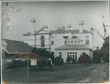
Otira was designed and built in 1887 by architect Mr Crouch, first Secretary of the Institute of Architects for Mr Henry Berry, founder of a successful wholesale grocery business. The house was acquired by the Methodist Church in 1923 for use as a home missionary training college. The house is of faced stone on a bluestone foundation. The large front door is surrounded by lead light windows surmounted by a fan light. The land on which the house stands has now been subdivided.B & W gloss photograph mounted on card of the rear of Otira, the Home Missionary Training College located at 73 Walpole Street Kew. Otira 73 Walpole Street Kew. Home MIssionaries Training College. otira, methodist home missionary training school walpole street kew, henry berr crouch -
 Uniting Church Archives - Synod of Victoria
Photograph, undated
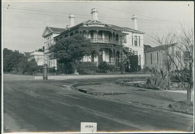
Otira was designed and built in 1887 by architect Mr Crouch, first Secretary of the Institute of Architects for Mr Henry Berry, founder of a successful wholesale grocery business. The house was acquired by the Methodist Church in 1923 for use as a home missionary training college. The house is of faced stone on a bluestone foundation. The large front door is surrounded by lead light windows surmounted by a fan light. The land on which the house stands has now been subdivided.B & W gloss photograph mounted on card of Otira, the Home Missionary Training College located at 73 Walpole Street Kew. The photograph was taken from the street.Otira 73 Walpole Street Kew. Home MIssionaries Training College. otira, methodist home missionary training college walpole street kew, henry berr crouch -
 Greensborough Historical Society
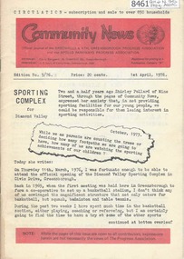
Newsletter, Greenhills and North Greensborough Progress Association, Community News: official journal of the Greenhills and Nth.Greensborough Progress Association and the Apollo Parkways Progress Association. 1st April, 1976. Edition No. 3/76, 01/04/1976
This edition includes a report on the The Apollo Parkways Progress Association's March 1976 meeting, Sporting complex for Diamond Valley, History in the district, 300 miles of park... the forestry concept, This and that, Functions of your local Health Department, School and Kinder news, Guide news, Battle of the bluestone, From the Council Chamber, Meet the natives, Diamond Valley Repertory, Apex Club in Greensborough. A digital copy of this Newsletter is available from Greensborough Historical Society. Newsletter, 28 p., illus.greenhills and north greensborough progress association, greenhills, apollo parkways progress association, apollo parkways -
 Ballarat Tramway Museum
Newspaper, The Courier Ballarat, "Historic Wall", 1953
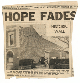
Yields information about a historical wall at the Ballarat Power station and its relationship to a previous land owner.Newspaper clipping from The Courier, 26/8/1953 of a photograph and caption of the bluestone wall at Ballarat A power station, noting it was a remnant of Fry's flour mill. Also notes when the power station foundation stone was laid. Item was contained within Reg Item 5507 - Foolscap binder with green covers, black binding edge and metal clips - see btm5507-list.pdf for actual location. Hi Res scan added 16-12-2015.power station -
 Glenelg Shire Council Cultural Collection
Painting, Greenmount, n.d
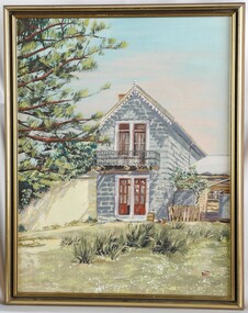
CEMA Art Collection Previously located in History HouseThe painting depicts a double storey bluestone building with a pair of red doors on both storeys. The top storey has a small balcony with black railing. To the right of the building is a single storey wooden building with two water tanks out the front. To the left of the building is a yellow wall and the edge of a tall Norfolk Pine. In the foreground is a grass area with clumps of tall grass. The background is a blue and grey sky. The work has a gold and black frame and exposed canvas.Front: DEB Back: (No inscriptions) -
 Eltham District Historical Society Inc
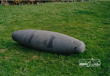
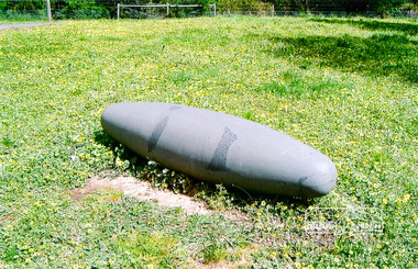
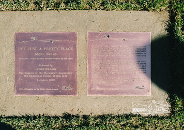
Photograph, Not Just a Pretty Place, Aleks Danko (2000), Lennister Farm, Eltham South, 2000c
Not Just a Pretty Place acknowledges the cultural significance of this site for the residents of Nillumbik Shire and for the Wurrundjeri community. Historically the confluence of rivers have particular importance as these were sites where rituals and ceremonies took place. The carved bluestone form presents an oversize river pebble that echoes the spirit of the water and draws attention to this location as a meeting place an landmark. Awarded the 2000 Nillumbik Art in Public Places Award and situated behind Lennister Farm near Yarra ParkColour photograph printaleks danko, eltham, lennister farm, yarra park -
 Eltham District Historical Society Inc
Photograph, Not Just a Pretty Place, Aleks Danko (2000), Lennister Farm, Eltham South, 2000c
Not Just a Pretty Place acknowledges the cultural significance of this site for the residents of Nillumbik Shire and for the Wurrundjeri community. Historically the confluence of rivers have particular importance as these were sites where rituals and ceremonies took place. The carved bluestone form presents an oversize river pebble that echoes the spirit of the water and draws attention to this location as a meeting place an landmark. Awarded the 2000 Nillumbik Art in Public Places Award and situated behind Lennister Farm near Yarra ParkColour photograph printaleks danko, eltham, lennister farm, yarra park -
 Sunbury Family History and Heritage Society Inc.
Photograph, c1910 - 1920s
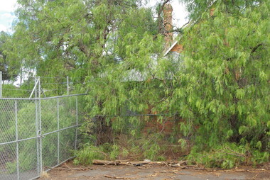
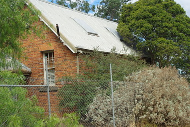
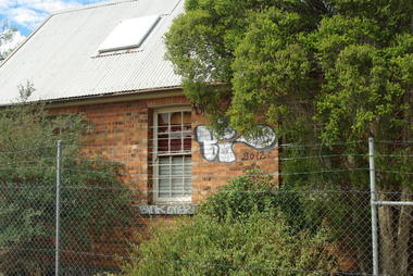
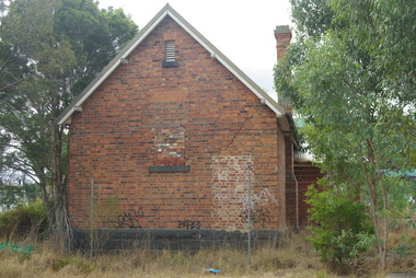
The photo is of the Sunbury State School No. 1002, which replaced an earlier building. The Federation style red-brick school was built in 1911 and was officially opened on 2nd May 1912. An extra room was added in 1945 to accommodate increased enrolment. In 1999 the school closed at the Stawell Street site and the students relocated to the former and refurbished bluestone Industrial School in Jacksons Hill. The former red-brick school building is now part of the Sunbury Community Health Centre complex.Many former and present-day residents in Sunbury have attended this school over the years.A black and white photograph of a small school building. It is a federation style building with brick walls and a tiled roof.sunbury state school no. 1002. -
 Bendigo Historical Society Inc.
Photograph - BENDIGO HISTORICAL SOCIETY COLLECTION: RUINS OF MIA MIA HOTEL
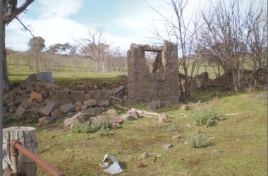
Colour photograph of bluestone ruins of former Mia Mia Hotel, Mia Mia. Part of one wall standing with window opening. Bare trees in background and on side. Burke and Wills Expedition travelled through this region and allegedly visited the Mia Mia Hotel. The Burke and Wills expedition passed through Mia Mia in 1860 on their journey across Australia from Melbourne to the Gulf of Carpentaria. They arrived on Saturday, 25 August 1860 and made Camp VI at Mia Mia.buildings, commercial, mia mia hotel -
 Bendigo Historical Society Inc.
Photograph - BENDIGO HISTORICAL SOCIETY COLLECTION: BURKE AND WILLS CAIRN BARNADOWN
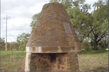
Colour photograph of bluestone fireplace erected at Barnadown to commemorate the camp site of the Burke and Wills expedition.The stone fireplace is a memorial to the Burke and Wills Expedition which camped near here. It was erected by the Waranga Shire Council to commemorate the centenary of the Victorian Exploring Expedition`s passage through the Barnadown district in 1860. A plaque on the structure reads: 'Burke and Wills Centenary. The party camped near this spot on 28th August 1860 on its outward journey. Erected by the Shire of Waranga 1960'.exploration, terrestrial, burke and wills -
 Bendigo Historical Society Inc.
Photograph - BENDIGO HISTORICAL SOCIETY COLLECTION: REDESDALE BRIDGE
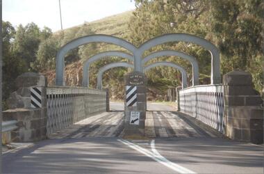
Colour photograph of the Redesdale bridge over the Campaspe River at Redesdale. The Redesdale Bridge is one of the oldest iron lattice-truss bridges in Victoria, Australia. The Redesdale Bridge is a wrought iron and timber structure with bluestone abutments, located over the Campaspe River near the town of Redesdale. Image taken from Redesdale side of bridge showing two lane design. Plaque on bridge in centre of divided road reads ' Shire of Metcalfe'. Photo taken during a BHS tour, possibly 1990's.bridge -
 Bendigo Historical Society Inc.
Photograph - RAILWAYS COLLECTION: PHOTO OF A SKETCH OF 'JACKSON CREEK VIADUCT OPENING
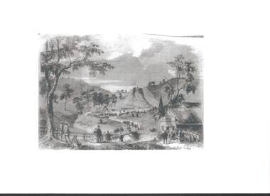
Railways collection -photo of a sketch of 'Jackson Creek Viaduct Opening (Courtesy ARHS Vic Division Inc.)'. The Jackson Creek Viaduct is a bridge about 24 miles from Melbourne and is 80 feet high being constructed of Footscray Bluestone piers and abutments and wrought iron girders. The girders were made in England and delivered to the colony by the time the the piers were ready to receive them. The laying of the foundation stone of this viaduct marked the opening of the line to Sunbury on 13 January 1859.photo, 'jackson creek viaduct -
 Surrey Hills Historical Society Collection
Photograph, Preparing to leave for the St George's Church of England Sunday School picnic, Mont Albert Road, 1922, 1922
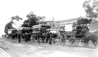
The drags would have been leaving St George's Church of England in Mont Albert Road. The foundation stone for St George's Church of England, Mont Albert was laid in 1886 on land donated by Edward Dyer and the first service was preached in January 1887. From 1904 until 1907 it was known as Holy Trinity, Surrey Hills. The original church was weatherboard and replaced by a brick one in the Gothic Revival style which was designed by local architect George J V Blackburne, who also designed the Wesleyan School at Surrey Hills. The building was partly funded by donations, profits from a bazaar and concert, and other people donated furnishings. The church had boundaries along Mont Albert Road and St Georges Road. In 1998 the Church was sold and converted into a complex of units. Its current address is 19 St Georges Avenue, Mont Albert. The annual Sunday School picnic was held at Hampton and drags were the usual mode of transport. 'Lugano' was built in 1893 for William Wilson, a prominent stonemason and importer of marble fireplaces. In 1903 it became the home of William Holmes who was Chief Electrical Engineer for the Victorian Railways. He designed the electrification of the Melbourne suburban network. 'Lugano' stayed in the Holmes family until the 1930s. The annual Sunday School picnic was held at at a variety of locations and drags were the usual mode of transport. Donor information is that this was taken as the congregation prepared to depart for at Hampton on the picnic held on 25/2/1922. There are 2 copies: the original donated print and an enlargement. The original was mounted on card with photo mounts along with 506, 871, 872, and 873. It measures 13 cm x 9 cm.Black and white photo of 4 'drags' (horse-drawn hooded carriages) lined up in Mont Albert Road near the corner of St George's Avenue, in readiness for departure for the Sunday School picnic. The carriages are loaded with people and decorated with flags. The front carriage has a material sign attached to the side; the top line of writing is not decipherable, but the bottom one reads "SURREY HILLS". Four men stand in the road, which has bluestone curb and channelling. In the background is 'Lugano'.On rear in ink: "S.S. picnic to Hampton / 25th. Feb. 1922" and in a different hand in biro: "At Mont Albert. St George's Church"churches, holy trinity church, anglican church, sunday schools, picnics, lugano, horse-drawn vehicles, william wilson, willaim holmes, st george's church of england, mont albert, mont albert road -
 Ballarat Heritage Services
Photograph - Image - Colour, Clare Gervasoni, Ercildoun Workers Cottage, 2008, 10/05/2008
The photograph was taken during an opening on Ballarat Heritage Weekend. Colour image of a brick workers building on the Ercildoun property established by squatters the Learmonth Brothers. architecture, garden, bluestone, ballarat heritage weekend, ercildoun, ercildoune, workers cottage, squatter, settlement -
 Ballarat Heritage Services
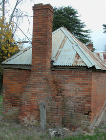
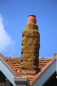
Photograph - Digital photographs, L.J. Gervasoni, Port Fairy Primary School Chimney, 2016
Digital images of chimnies at Port Fairy Primary School port fairy, state school, school, primary school, victoria, education, bluestone, heritage, chimney -
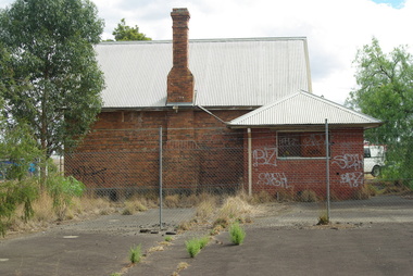
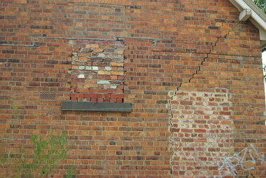
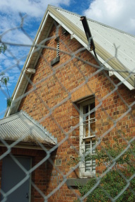
 Greensborough Historical Society
Photograph - Digital Image, Bundoora Primary School Bu1915 (old building) 1, 18/03/2014
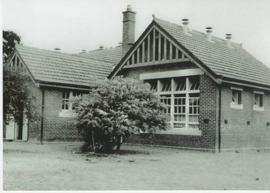
Bundoora Primary School No.1915 was constructed in 1877 of brick on a bluestone base with an iron roof and small porch. The school consisted of a single room with the dimensions 30 feet by 18 feet. It was a small rural school and in use for over 100 years. Today it sits abandoned at the intersection of Plenty Road and the Metropolitan Ring Road. The School has a Victorian Heritage Overlay (no H062) Photograph by Marilyn Smith 2014. Update: The old building has been incorporated into a childcare facility.Digital copy of colour photograph. bundoora primary school, bundoora state school -
 Greensborough Historical Society
Photograph - Digital Image, Bundoora Primary School Bu1915 (old building) 2, 18/03/2014
Bundoora Primary School No.1915 was constructed in 1877 of brick on a bluestone base with an iron roof and small porch. The school consisted of a single room with the dimensions 30 feet by 18 feet. It was a small rural school and in use for over 100 years. Today it sits abandoned at the intersection of Plenty Road and the Metropolitan Ring Road. The School has a Victorian Heritage Overlay (no H062) Photograph by Marilyn Smith 2014. Update: The old building has been incorporated into a childcare facility.Digital copy of colour photograph. bundoora primary school, bundoora state school -
 Greensborough Historical Society
Photograph - Digital Image, Bundoora Primary School Bu1915 (old building) 3, 18/03/2014
Bundoora Primary School No.1915 was constructed in 1877 of brick on a bluestone base with an iron roof and small porch. The school consisted of a single room with the dimensions 30 feet by 18 feet. It was a small rural school and in use for over 100 years. Today it sits abandoned at the intersection of Plenty Road and the Metropolitan Ring Road. The School has a Victorian Heritage Overlay (no H062) Photograph by Marilyn Smith 2014. Update: The old building has been incorporated into a childcare facility.Digital copy of colour photograph. bundoora primary school, bundoora state school -
 Greensborough Historical Society
Photograph - Digital Image, Bundoora Primary School Bu1915 (old building) 4, 18/03/2014
Bundoora Primary School No.1915 was constructed in 1877 of brick on a bluestone base with an iron roof and small porch. The school consisted of a single room with the dimensions 30 feet by 18 feet. It was a small rural school and in use for over 100 years. Today it sits abandoned at the intersection of Plenty Road and the Metropolitan Ring Road. The School has a Victorian Heritage Overlay (no H062) Photograph by Marilyn Smith 2014. Update: The old building has been incorporated into a childcare facility.Digital copy of colour photograph. bundoora primary school, bundoora state school -
 Greensborough Historical Society
Photograph - Digital Image, Bundoora Primary School Bu1915 (old building) 5, 18/03/2014
Bundoora Primary School No.1915 was constructed in 1877 of brick on a bluestone base with an iron roof and small porch. The school consisted of a single room with the dimensions 30 feet by 18 feet. It was a small rural school and in use for over 100 years. Today it sits abandoned at the intersection of Plenty Road and the Metropolitan Ring Road. The School has a Victorian Heritage Overlay (no H062) Photograph by Marilyn Smith 2014. Update: The old building has been incorporated into a childcare facility.Digital copy of colour photograph. bundoora primary school, bundoora state school -
 Greensborough Historical Society
Photograph - Digital Image, Bundoora Primary School Bu1915 (old building) 6, 18/03/2014
Bundoora Primary School No.1915 was constructed in 1877 of brick on a bluestone base with an iron roof and small porch. The school consisted of a single room with the dimensions 30 feet by 18 feet. It was a small rural school and in use for over 100 years. Today it sits abandoned at the intersection of Plenty Road and the Metropolitan Ring Road. The School has a Victorian Heritage Overlay (no H062) Photograph by Marilyn Smith 2014. Update: The old building has been incorporated into a childcare facility.Digital copy of colour photograph. bundoora primary school, bundoora state school -
 Greensborough Historical Society
Photograph - Digital Image, Bundoora Primary School Bu1915 (old building) 7, 18/03/2014
Bundoora Primary School No.1915 was constructed in 1877 of brick on a bluestone base with an iron roof and small porch. The school consisted of a single room with the dimensions 30 feet by 18 feet. It was a small rural school and in use for over 100 years. Today it sits abandoned at the intersection of Plenty Road and the Metropolitan Ring Road. The School has a Victorian Heritage Overlay (no H062) Photograph by Marilyn Smith 2014. Update: The old building has been incorporated into a childcare facility.Digital copy of colour photograph. bundoora primary school, bundoora state school -
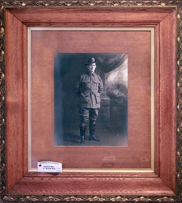 City of Moorabbin Historical Society (Operating the Box Cottage Museum)
Photograph - Alonzo Box in Army Uniform c1915, Unrecorded, c1915
Alonzo Box was the nephew of William and Elizabeth Box who resided in the Cottage 1865 - 1913. He was the 9th child of John Box 1841 - 1913 and Martha Sheldrake Box who lived in Oakleigh, Alonzo enlisted in the Army and landed at Gallipoli 25/41915. After the evacuation to Egypt he served in France and Flanders and returned to Melbourne February 1918. Alonzo was a pavier / pitcher who was employed to lay the bluestone drains for the roads and sewerage channels in Moorabbin Shire - a skilled and well paid occupation. Alonzo Box was the 9th child of John Box ,who emigrated to Australia in 1854 with his parents, George and Mary Box , and siblings who included William Box. Alonzo enlisted in the 1st AIF and landed at Gallipoli 25/4/1915. After the evacuation to Egypt he served in France and Flanders before returning to Melbourne in February 1918. He married Mary Closter in June 1918. His elder sister Rebecca, who was a missionary in China, sent a bolt of hand embroidered Chinese silk to Mary for her Wedding Dress. This unique dress is on display at Box Cottage Museum and is recorded on the Australian Dress Register 2015.A large photograph in a wooden frame of Alonzo Box 1881-1958 in 1st AIF Army Uniform c 1915box william, box elizabeth, box alonzo, box mary, closter mary, moorabbin, brighton, bentleigh, ormond, mckinnon, market gardeners, pioneers, early settlers, paviers, roads, sewers, world war 1914-1918, anzac, gallipoli, uniforms australian army, box john, sheldrake martha -
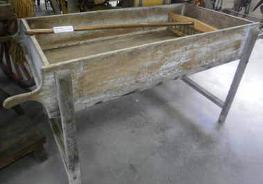 Cheese World Museum
Table, Cheddar cheese table
Believed to have come from Tooram where it was used for cheese making. Tooram commenced cheese manufacture in the mid 19th century in a purpose-built bluestone factory beside the homestead. It was initially set up by Pierce and a long article in the Warrnambool Standard describes the factory and its processes. Cheese production continued through changes of ownership until the 1930s when the Uebergangs ceased making cheese on site. The table was auctioned at Panmure and purchased by 'Flapper' Clarke of Panmure who donated it to the museum in 2012.Rectangular wooden table with trough top, two rounded handles at either end and four legs with stays at either end; has been lime washed on the outside.rural industry, agriculture, food technology, dairying, food processing, allansford, tooram, panmure, cheese making, clarke -
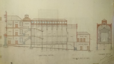 Unions Ballarat
Plan - Photograph: Trades Hall building architects' design, 1886
Original architects' drawings for the construction of Trades Hall, Ballarat. November 5th 1886 the building committee called for tenders for the erection of a Trades Hall on the following conditions. The amount to be expended to be no more than £3,000; bluestone foundations; the front of the building to be of Grampians freestone and walls of brick. Building to be 3 storeys high, containing 14 rooms with a hall capable of seating 600 persons, roof to be of slate and workmanship and material to be of the best quality. The design submitted by Messrs James and Piper was accepted subject to amendment.Relevance to the history of Trades Hall, Ballarat.Paper - architects' plans.btlc, ballarat regional trades and labour council, ballarat trades and labour council, ballarat trades hall, eight hours anniversary committee, james and piper, architects' drawings, building -
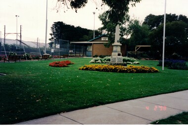 Whitehorse Historical Society Inc.
Photograph, Blackburn War Memorial
Built after World War 1, the monument originally stood on the corner of Whitehorse & Railway Roads before being moved to Morton Park on 20th April 1969. The memorial was erected in memory of those from the district who were killed during WW1. Those who lost their lives in WW2 were added on the other side of the memorial as well as plaques commemorating later conflicts. The monument is a grey granite obelisk on a single stepped bluestone base on a concrete platform.Coloured photograph of a war memorial surrounded by flower gardens. Blackburn Tennis Club , rooms & courts on the left.blackburn war memorial, war memorials -
 Bendigo Historical Society Inc.
Document - 257 & 267 View Street Two Terrace house
A miner from the Hustler's Hill mine struck a rich vein of gold and suggested George Lansell should buy all available share and enter into a partnership with him. The resulting fortune allowed the miner to build these substantial cottages of bluestone and named them Mt Pleasant House and View Hill House. They were later known as Bellyache Terrace. No 267 was eventually sold to G H Tatchell, solicitor. It was then bought by his son Charles Tatchell and remained in the family until 1939.A paper detailing the history of the two terrace house at 257 & 267 View Street. 1 Page. view street, house, goldfield -
 Eltham District Historical Society Inc
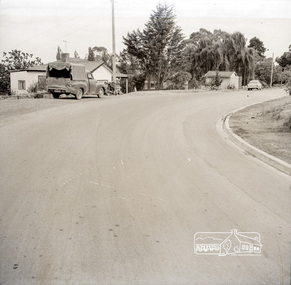
Photograph, Near 145 Mountainview Road, Briar Hill, early to mid 1960s, 1960s
Work is under way at the house one down from the bend where two piles of bluestone are gathered; possibly for terrace edging of the driveway and footpath. These images were from a strip of negatives, most likely taken by a Shire of Eltham employee so the works could have been part of council operations. Many streets in the shire have stonework edges for gardens abutting footpaths where the roads have been cut into the terrain. Much of this stone masonry work was undertaken for the council by C.J. Watson and Sons.Roll of medium format 120 6x6 black and white negative film, 1 stripbriar hill, c.j. watson and sons, fx holden, mountainview road, side-car, motorcycles -
 St Kilda Historical Society
Photograph, St Kilda Library alterations 1993-94 - images collection, 1994
St Kilda Library was designed in 1971 by Enrico Taglietti (1926-2019). It was to be constructed in two stages. Stage 1 was completed in 1973. Stage 2 as designed by Taglietti did not proceed. Instead, alterations were designed in 1992-93 by Ashton Raggatt McDougall Architects (ARM). In 1993-94, the floor area of the library was enlarged to include a new entry and disabled ramp and a pedestrian thoroughfare between Carlisle and Duke streets. The original entry was blocked and a bluestone 'book' wall was constructed west of the new entry.colour photograph unmountedSK Libraryst kilda library, enrico taglietti, arm architects