Showing 14542 items matching "bridge-playing"
-
 Eltham District Historical Society Inc
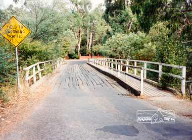
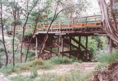
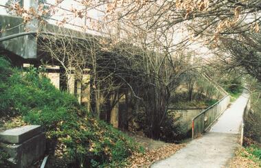
Photograph, Diamond Street Bridge, Eltham
Three colour photographs showing Diamond Street Bridge over Diamond Creek, Eltham prior to reconstructioneltham, diamond street, bridges, diamond creek -
 Eltham District Historical Society Inc
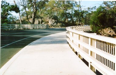
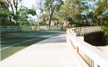
Photograph, Diamond Street Bridge, Eltham
Five colour photographs showing Diamond Street Bridge over Diamond Creek, Eltham after reconstructiondiamond street, eltham, bridges, diamond creek -
 Stawell Historical Society Inc
Photograph, New Halls Gap Bridge
Digital Print: View of Part of the New Halls Gap Bridge, near the curve heading toward Stawell -
 Stawell Historical Society Inc
Photograph, New Halls Gap Bridge
Digital Print: View of Part of the New Halls Gap Bridge, near the curve heading toward Stawell -
 Whitehorse Historical Society Inc.
Photograph, Bridge Work Deep Creek Road, 1/02/2002 12:00:00 AM
Coloured Photo of last Span being put into place on Bridge over Deep Creek Road, Mitcham.deep creek road, mitcham. -
 Buninyong & District Historical Society
Photograph - Photo of Original Photograph, Wal Larsen, B/W photo of Victoria St Bridge, Ballarat, over Buninyong Railway line, in June 1940, June 1940
Railway and surrounds in 1940.B/W photo of Victoria St Bridge, Ballarat, over Buninyong Railway line, in June 1940buninyong, railway, bunny, cutting, victoria st., bridge -
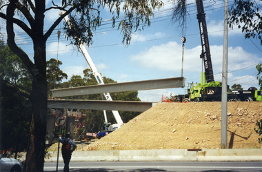
![Photographs [Series], Noel Kelly, Chandler Highway Bridge Construction, 11/07/2018](/media/collectors/550653872162f11fb04854aa/items/5c2f52bd21ea670d20783d9e/item-media/5c2f53b221ea670d2079233e/item-fit-380x285.jpg) Kew Historical Society Inc
Kew Historical Society IncPhotographs [Series], Noel Kelly, Chandler Highway Bridge Construction, 11/07/2018
A selection of photographs taken in July/August 2018 recording work on the old and new Chandler Highway Bridges.chandler highway bridge, noel kelly, railway viaduct - river yarra -
 Lakes Entrance Historical Society
Book, Davidson, Rachael, The Nicholson River Railway Bridge, 2004
Research, interpretation and management recommendations for the Nicholson River Railway Bridge, East Gippsland, Victoria, by a Forestec student.bridges, transport -
Lakes Entrance Historical Society
Book, Van der Heyden Becky, Calulu Mitchell River Bridge, 2004
Research interpretation and management recommendations for the Calulu Mitchell River Bridge, near Bairnsdale, Victoria by a Forestec Studentbridges, waterways, settlers -
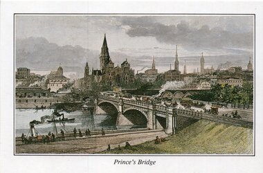 Melbourne Tram Museum
Drawing - Illustration, St Paul's Cathedral, "Engraving of Prince's Bridge and St Paul's Cathedral, Melbourne 1889", 1992
Illustration - colour engraving printed onto white card, titled "Princes Bridge" showing the planned St Paul's Cathedral, Flinders St Station, Princes bridge with cable trams and the Yarra River with steam powered boats. On rear - "Engraving of Prince's Bridge and St Paul's Cathedral, Melbourne 1889" with a note that it was drawn before the completion of the cathedral the design shows in that intended by the Architect, William Butterfield and that it was from the collection of St Paul's Cathedral.trams, tramways, yarra river, st pauls cathedral, melbourne, greetings cards -
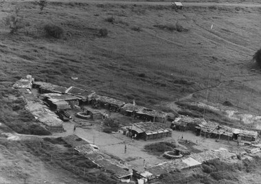 National Vietnam Veterans Museum (NVVM)
Photograph, Gibbons, Denis, National Route 23 Bridge
Denis Gibbons (1937 – 2011) Trained with the Australian Army, before travelling to Vietnam in January 1966, Denis stayed with the 1st Australian Task Force in Nui Dat working as a photographer. For almost five years Gibbons toured with nine Australian infantry battalions, posting compelling war images from within many combat zones before being flown out in late November 1970 after sustaining injuries. The images held within the National Vietnam Veterans Museum make up the Gibbons Collection. A black and white photograph of a South Vietnamese Regional Outpost on Vietnams National Route 23 built near a bridge built by Engineers of 1 Australian Task Force Base, Nui Dat. The Vietnamese Regional Force soldiers had the responsibility for protecting the bridge against attack.photograph, south vietnamese regional force, national route 23, 1st atf base, nui dat, gibbons collection catalogue, engineers, 1st australian task force, denis gibbons -
 National Vietnam Veterans Museum (NVVM)
Photograph, Gibbons, Denis, Bridge Building
Denis Gibbons (1937 – 2011) Trained with the Australian Army, before travelling to Vietnam in January 1966, Denis stayed with the 1st Australian Task Force in Nui Dat working as a photographer. For almost five years Gibbons toured with nine Australian infantry battalions, posting compelling war images from within many combat zones before being flown out in late November 1970 after sustaining injuries. The images held within the National Vietnam Veterans Museum make up the Gibbons Collection. A black and white photograph of Engineers from 17 Construction Squadron, build a bridge across on of the many creeks and streams which had been previously destroyed by NVA/VietCong forces and some as long ago as the war with the French. These bridges were built with solid steel foundations.photograph, 17 const sqn, nva/vc, gibbons collection catalogue, engineers, nva/vietcong, denis gibbons -
![Newspaper Clipping - Digital Image, End of Plenty Bridge 1968 [Bluestone Bridge Greensborough], 16/04/1968](/media/collectors/4f729f5697f83e03086015b8/items/5eb3aa9d21ea670b94feceb5/item-media/5eb3acc621ea670b9400fd28/item-fit-380x285.jpg) Greensborough Historical Society
Greensborough Historical SocietyNewspaper Clipping - Digital Image, End of Plenty Bridge 1968 [Bluestone Bridge Greensborough], 16/04/1968
Removal of the bluestone bridge over the Plenty River in 1968. Photograph shows workmen removing the steel girders which covered the centre span. Pioneer Reserve is also mentioned.News clipping, black and white text and image.plenty river greensborough, bluestone bridge greensborough, pioneer reserve greensborough -
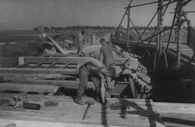
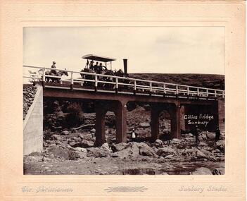 Hume City Civic Collection
Photograph
Chris. Christiansen was a barber in Sunbury. He also ran a photographic studio from 1892 - 1916. His business was situated on the corner of Evans and Brook Streets. The Gillies Bridge is Situated on the Wildwood Road just off the Lancefield Road.A mounted sepia photograph of the Gillies Bridge at Sunbury. Across the bridge there are three men on a steam roller and one man behind on horseback. There are four men standing across the creek bed. The mounting is cream, 2 cm wide with silver writing under the photo. Cream mounting - 2 cm wide with silver inscriptionsGILLIES BRIDGE / SUNBURY / CHR. CHRISTIANSEN /gillies bridge, wildwood bridge, bridges, horses, christiansen, chris, photographers, animals, steam rollers, sunbury, men, clothing and dress, george evans collection -
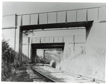
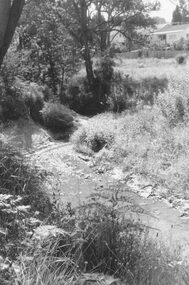 Ringwood and District Historical Society
Photograph, Mullum Creek, 50 yards west of bridge in Ringwood Street Ringwood. May 1971
Writing on back of small photograph reads, "May 1971. Mullum Creek, 50 yards west of bridge in Ringwood St." Enlargement reads, "Mullum Creek looking west from bridge in Ringwood St. July 1972". -
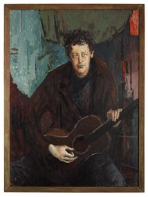 The Dunmoochin Foundation
Oil Painting, Portrait of Brian Mooney, 1965
Portrait of a seated man with dark curly hair and brown jacket playing a guitar against an abstract multi-coloured background. Signed and dated lower right 'Clifton Aug 65'.clifton pugh, painting, portrait, brian mooney, guitar -
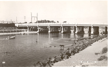 Chelsea & District Historical Society Inc
Photograph - Patterson River, Rail and Road Bridge, Carrum
The first bridge over the river was built in the early 1880's, prior to this it was a pontoon bridge. In 1927 a concrete bridge was built to replace the wooden bridge.Black and white photo of Patterson River, taken from Beauty Point, Carrum Victoria. patterson river, chelsea, patterson river bridge, carrum bridge, beach, leisure, beauty point, boats -
 Upper Yarra Museum
Negative Photographic Reproduction, A tramway bridge under construction, 1910 Mr Hansen & Andy
A tramway bridge under construction, 1910 Mr Hansen & Andy Negative Black white. Scanned at 600 dpitramway bridge construction curved hand winch mr hanson andy 1910 -
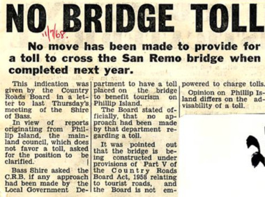 Phillip Island and District Historical Society Inc.
Newspaper Clipping, No Bridge Toll, 11/7/1968
Article from a collection of newspaper clippings from October 1968 to July 1971Newspaper article about no move made to provide for a toll to cross the San Remo bridge when completed in 1969.phillip island, san remo bridge, bridge toll -
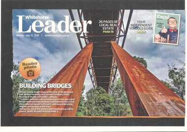 Whitehorse Historical Society Inc.
Article, Burwood Link Pedestrian Bridge, 2018
Sketch map of location of potteries in the area bounded by Middleborough, Springfield, Mitcham Roads and Burwood Highway.Photograph of the Burwood Link Pedestrian Bridge at Gardiners Creek Reserve provided by Whitehorse Leader reader Aisling Keogh.Sketch map of location of potteries in the area bounded by Middleborough, Springfield, Mitcham Roads and Burwood Highway.deakin university burwood campus, burwood link pedestrian bridge, gardiners creek reserve -
![Photographs [Series], Noel Kelly, Chandler Highway Bridge Construction, August 2018, 07/08/2018](/media/collectors/550653872162f11fb04854aa/items/5c2f545421ea670d20799ebb/item-media/5c2f54c721ea670d207a1d1c/item-fit-380x285.jpg) Kew Historical Society Inc
Kew Historical Society IncPhotographs [Series], Noel Kelly, Chandler Highway Bridge Construction, August 2018, 07/08/2018
The second of a series of photographs taken in July/August 2018 recording work on the old and new Chandler Highway Bridges.chandler highway bridge -
Lakes Entrance Historical Society
Book, Barned, Kim, Tambo Upper Low Level Bridge, 2003
Research, interpretation and management recommendations for the Tambo Upper Low Level Bridge, East Gippsland,Victoria, by a Forestec student.bridges, waterways, natural disasters -
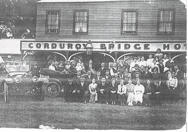 Buninyong & District Historical Society
Photograph - Copy of original photograph, Corduroy Bridge Hotel, Clarendon around 1914, Corduroy Bridge Hotel, Clarendon around 1914
BuildingsB&W copy of original photograph, Corduroy Bridge Hotel, Clarendon around 1914. Burnt down in 1916. -
Phillip Island and District Historical Society Inc.
Photograph
Phillip Island suspension Bridge built 1938/1940 - demolished 1970. Part of an album compiled and donated by Mrs Helen Jansson.Print of Phillip Island Suspension Bridge. Aerial view showing Jetties at left with sweep of sandy beaches middle to top left.No. 1. Phillip Island Bridge, Victoria. Airapy Photolocal history, photography, photographs, slides, film, civil engineering, bridges, jetties, phillip island suspension bridge, black & white photograph, mrs. helen jansson, suspension bridges, phillip island -
 Ringwood and District Historical Society
Photograph, Mullum Creek from bridge in Warrandyte Rd. Looking east, 1972
Written on backing sheet, "Mullum Creek from bridge in Warrandyte Rd. Looking east, 1972" -
 Ringwood and District Historical Society
Photograph, Mullum Creek from bridge in Warrandyte Rd. Looking east, 1973
Written on backing sheet, "Mullum Creek from bridge in Warrandyte Rd. Looking east, 1973". -
 Ringwood and District Historical Society
Photograph, Bridge over Mullum Creek under construction, Oliver Street. 1963
2 photographsWritten on back of photograph, "Bridge over Mullum Creek, Oliver Street. 17/11/1963" -
 Ringwood and District Historical Society
Photograph, Warrandyte Road Bridge over Mullum Mullum Creek, Ringwood 1986
Written on back of photograph, "3.8.86. Ringwood. Warrandyte Road Bridge over Mullum Mullum Creek". -
 Ringwood and District Historical Society
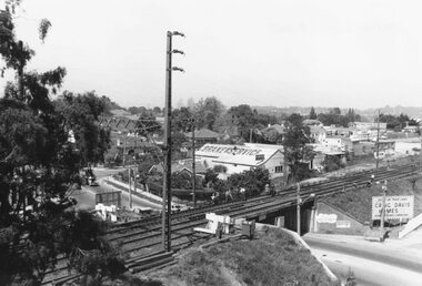
Photograph, View from Ringwood Clocktower overlooking Wantirna Road railway bridge and Thanet Street corner - Dec. 1969
Black and white photographWritten on back of photograph: "Wantirna Rd bridge. from clocktower, 1969". Thanet Street corner. -
 Ringwood and District Historical Society
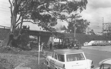
Photograph, Maroondah Highway West, Ringwood- 1965. Wantirna Road bridge widening
Black and white photograph (2 copies)Written below one photograph: "Wantirna Road railway bridge- preparing to widen underpass, 1965.