Showing 8357 items matching "bridges"
-
 Marysville & District Historical Society
Document (Item) - Transcription of a newspaper article, New Bridge Named After Former Shire Councillor, 1965
A transcription of a newspaper article of the naming of the F.J. Barton Bridge in Marysville in Victoria.A transcription of a newspaper article of the naming of the F.J. Barton Bridge in Marysville in Victoria.marysville, victoria, fj barton, steavenson river, healesville shire council, fred barton, thomas barton, fj barton bridge -
 Marysville & District Historical Society
Photograph (item) - Colour photograph, 15-11-03
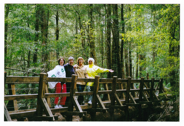
A colour photograph of a bridge that leads to Big Tree near Cambarville in Victoria.A colour photograph of a bridge that leads to Big Tree near Cambarville in Victoria. It was, at one stage, known to be the tallest hardwood tree in the world standing at 92 meters (301ft, 6 inches). However, it was reduced to 84 meters by a wind storm in 1959. It is a mountain ash. There is a walking track through the forest to the Big Tree.A weekend at Marysville 15-11-03 Catherine Pat Natasha & Normabig tree, mountain ash, cambarville, victoria, photograph -
Marysville & District Historical Society
Document (Item) - Heritage Report, Biosis Research Pty Ltd, Heritage Report-Dismantling of Wilks Creek Brdige Deck Marysville, Unknown
A heritage report on the dismantiling of the Wilks Creek Bridge deck in Marysville in Victoria.A heritage report on the dismantiling of the Wilks Creek Bridge deck in Marysville in Victoria. The Wilks Creek Bridge is a former timber and bluestone road bridge on the Yarra Track, and is located just off the Black Spur route, between Narbethong and Marysville, Victoria, Australia. It was built in 1870 to the design of colonial Public Works Department engineer Clement Wilks as part of the construction of a new road to the Woods Point and Jordan Goldfields. Like many bridges of the period, it had a timber superstructure employing squared beams supported by struts and straining pieces, on cut bluestone abutments. The bridge was remodelled around 1900 by engineer John Monash of the famous bridge-engineering firm of Monash and Anderson. It was last used for heavy vehicular traffic in 1980 following the realignment of Marysville Road, and was left to decay until its demolishment in 2008. All timber traces of the bridge were destroyed in the 2009 Black Saturday fires. The handcrafted bluestone masonry wingwalls and abutments, especially shaped to receive timber struts, rate among the earliest of its kind surviving intact in Victoria.wilks creek bridge, yarra track, narbethong, marysville, victoria, clement wilks, wood's point goldfields, jordan goldfields, john monash, monash and anderson, 2009 black saturday bushfires -
 Marysville & District Historical Society
Photograph (Item) - Colour tinted photograph, 1878-1904
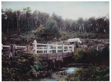
A copy of an early colour tinted photograph of a wooden bridge in Marysville in Victoria.A copy of an early colour tinted photograph of a wooden bridge in Marysville in Victoria. This photograph was taken by Nicholas John Caire between 1878 and 1904. Nicholas John Caire was born in 1837 in Guernsey. He arrived in Adelaide about 1860 along with his parents who encouraged his early interest in photography. He opened a studio in Adelaide in 1867 after traveling extensively throughout the Gippsland taking photographs. After marrying in 1870 he moved to Talbot in Victoria until 1876 when he opened a studio in the Royal Arcade in Melbourne. After 1885 Nicholas John Caire gave up his city work and made his home in South Yarra and devoted the rest of his life to outdoor photography, specializing in the bush, the gullies, and the mountains of south-eastern Victoria. nicholas john caire, marysville, victoria -
 Federation University Historical Collection
Book - Report, Report of Royal Commission into the Failure of West Gate Bridge, 1971, 1971
... bridges ....1) Foolscap soft brown covered report on the failure of the Westgate Bridge over the Yarra River. .2) Document relatng to the collapse of the Westgate Bridgewestgate bridge, bridges, royal commission, c.h. rixon, west gate, engineering -
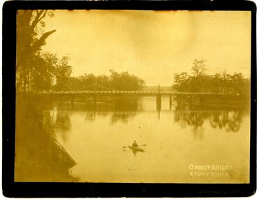
 Orbost & District Historical Society
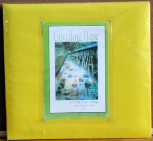
album, Walcott, Judy, Unveiling Hope on McKillops Bridge, 2005
This album was donated to the Orbost & District Historical Society after the death of Judy Walcott, a long-time member. The veiling of McKillops bridge was a 'Year of the Outback' event. The event was organised by Orbost resident, Sr Helen Barnes RSJ. to show solidarity with rural people. The local community transformed the bridge into "a symbol of communal love and hope", when its sides were draped with hundreds of personal messages. McKillop's Bridge, located high in the Snowy Mountains, is named after George McKillop, a pioneering explorer of the area. The bridge is a vital link for isolated farming communities living beyond the Bonang highway.This album is a useful reference tool.A large photo album with a bright yellow cover and 19 plastic sleeves. It contains photographs, newspaper clippings, brochures , maps and an invitation to the veiling of McKillops Bridge on 8th August 2002. It also contains the history of McKillops Bridge.On inside cover - left hand side - "To Marie with Best Wishes from Judy Walcott 8/8/2005"mckillops-bridge album -
 Port of Echuca
Photograph - Black and white photograph, Late 1970s
Relates to a series of 5 photos:P000094-P000098 of the front of the Bridge Hotel on the corner of Murray esplanade and Hopwood gardens. These photos, taken about 1976, were before the Port Restoration Scheme renovated the hotel. The Bridge Hotel was built by Henry Hopwood in 1858. This and the Bond Store were Echuca's first 2 brick buildings. Named from Hopwood's nearby pontoon bridge. The building was bought be The Council in 1970. Restored and reopened in 1975.The Bridge Hotel is an important part of Echuca's settlement and development. It was originally built by Henry Hopwood, the European founder of Echuca, in 1859. Hopwood built the hotel to provide accommodation to people using his punts across the Campaspe and Murray rivers that area central to the landscape of the Port. The hotel was situated on the land between both rivers and punts and provided for a variety of levels of accommodation from grand rooms to very basic rooms. At the time of the photos the hotel was 120 years old and became an important part of the Port of Echuca tourism. Black and white photograph of the Bridge Hotel , showing western wing before restoration.Stamped on the reverse "Gazemore Studio, D. G. Gay, 18 Frances Street Echuca 3625.bridge hotel, echcua, port restoration scheme, bridge hotel restoration, echuca -
 Orbost & District Historical Society
photograph, late 19th - early 20th century
Frank Richardson 1877-1950 was a sawmiller at Tabbara and helped build and run paddle steamer "Curlip"as engineer.This item is an early pictorial record of the old Snowy River bridge at Orbost.A large b/w photograph of the Snowy River bridge at Orbost. In the foreground there is a man in a small canoe with paddles. The photograph is pasted onto a black buff card. 2606.2 is a copy of the original used for display.On front : "Eastwood Bros, Bairnsdale, Orbost Bridge over Snowy River".photograph-snowy-river-bridge eastwood-bros -
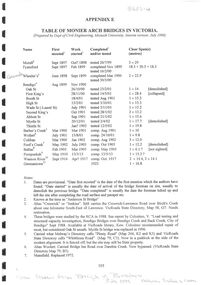 Bendigo Historical Society Inc.
Document - Table of Monier Arch Bridges in Victoria
In 1867, Frenchman Joseph Monier patented the use of metal reinforced concrete for use in horticultural troughs. Francois Hennebique expanded this idea into a general construction technique including for the construction of bridges with the first bridge built in 1875. In Victoria, Monash and Anderson, representatives of the Australian patent holders and later Victorian patent holders. The Bendigo Monier Bridges were built between 1901 and 1902. Monash's contribution was not in the actual technology but in the promotion and defence of the new technology that was faced by much doubt and scepticism.Single A4 sheet, Appendix E, photocopied from "The Monier Bridges of Bendigo" Includes dates and specifications of Victorian Monier Arched Bridges. Prepared by the Dept of Civil Engineering, Monash University. July 1988monier bridges, engineering -
 Port Fairy Historical Society Museum and Archives
Photograph, 1950
Rosebrook bridge opening - 1950PhotographOpening of Rosebrook Bridge Princes Highway, by the chairman of the C.R.B. Mr D.V. Davison? om thursday the 15th of June 1950 Bluestone abuttments of old bridge washed away by floods in 1946 in the foregroundnew rosebrook bridge - opening, 1950, bridge, opening -
 Buninyong & District Historical Society
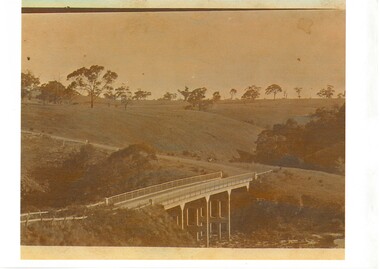
Photograph - Sepia photograph of original, Leigh Grand Junction Bridge, Leigh Grand Junction Bridge
Bridges, reinforced concrete construction by C.C.P.WilsonSepia photo, Photo of concrete bridge spanning gully, rolling landscape with scattered trees. leigh grand junction bridge, c.c.p. wilson -
 Orbost & District Historical Society
black and white photographs, November 1976
All of these photographs were taken prior to 25th November, 1876, the official opening and crossing of the current Snowy River Bridge. Gary Downey, an Orbost Apeian, did a "De Groot" and crossed the bridge on horseback prior to the official cars crossing the bridge to signal the opening of the new structure. There was a closing ceremony for the old bridge with a group arriving in a 1927 Chrysler, owned by Apexian, Peter Dreverman. This was watched by groups of school students. Some of the Apex members, including Jim Duggan, Noel Smart and Pat Hall, dressed in formal attire to speak to the audience.This event was organised by the Apex Club of Orbost.The Apex Club of Orbost was a volunteer service club which contributed to the Orbost community. A declining population has led to the demise of many social groups in the area.Ten black / white photographs related to the unofficial opening of the Snowy River Bridge at Orbost. snowy-river-bridge-1976 apex-club-orbost ceremony -
![Fern Bridge Gully, Black Spur / [by] Nicholas Caire, circa 1876](/media/collectors/550653872162f11fb04854aa/items/577b4c16d0cdd10948c8afab/item-media/577b4c75d0cdd10948c8ebe0/item-fit-380x285.jpg) Kew Historical Society Inc
Kew Historical Society IncPhotograph, Anglo-Australasian Photographic Company, Fern Bridge Gully, Black Spur, c. 1876
Nicholas Caire was born on Guernsey in the Channel Islands in 1837. He arrived in Adelaide with his parents in about 1860. In 1867, following photographic journeys in Gippsland, he opened a studio in Adelaide. From 1870 to 1876 he lived and worked in Talbot in Central Victoria. In 1876 he purchased T. F. Chuck's studios in the Royal Arcade Melbourne. In 1885, following the introduction of dry plate photography, he began a series of landscape series, which were commercially successful. As a photographer, he travelled extensively through Victoria, photographing places few of his contemporaries had previously seen. He died in 1918. Reference: Jack Cato, 'Caire, Nicholas John (1837–1918)', Australian Dictionary of Biography.An original, rare photograph from the series 'Views of Victoria: General Series' by the photographer, Nicholas Caire (1837-1918). The series of 60 photographs that comprise the series was issued c. 1876 and reinforced a neo-Romantic view of the Australian landscape to which a growing nationalist movement would respond. Nicholas Caire was active as a photographer in Australia from 1858 until his death in 1918. His vision of the Australian bush and pioneer life had a counterpart in the works of Henry Lawson and other nationalist poets, authors and painters.Views of Victoria (General Series), No.22 / ‘Fern Bridge Gully, Black Spur’ / Albumen silver photograph mounted on boardInscription on reverse: 'Fern Bridge Gully is situated near the summit of the Black Spur, about two miles from Fernshawe. Here the foliage is exceedingly dense, so much so as to exclude daylight in many places. This stream has derived its name from the fact of the Bridge having been constructed of large massive fern tree. The stream which flows beneath the Bridge is one of the sources of the River Watt.’nicholas caire (1837-1918), australia - landscape photography -
 Phillip Island and District Historical Society Inc.
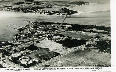
Photograph - Post Card, 1954
One of a collection of photographs donated by Daryl JohnsBlack & White photograph of aerial view over water and land. Newhaven in foreground and San Remo at rear of suspension bridge."The Rose Series P.14000. Aerial view showing Newhaven, San Remo & Suspension Bridge." Airspy Photo.phillip island, newhaven, san remo, daryl johns -
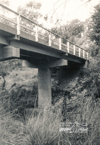
 Eltham District Historical Society Inc
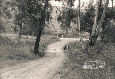
Photograph, Mittons Bridge, 1972c
... bridges ...Black and white photograph of Mittons Bridge over Diamond Creek c.1972bridges, mittons bridges, diamond creek, st andrews -
 Eltham District Historical Society Inc
Photograph, Old Warrandyte Bridge
... bridges ...Postcard showing old timber trestle Warrandyte Bridge over Yarra Riverbridges, yarra river, warrandyte, kangaroo ground road -
 Eltham District Historical Society Inc
Photograph, Watsons Creek Bridge, Christmas Hills, 1970c
... bridges ...Black and white photograph of bridge over Watsons Creek, Christmas Hills (Clintons Road?) c.1970bridges, watsons creek, christmas hills -
 Lakes Entrance Historical Society
Photograph, 2008
... Bridges ...Date made August 2008|This is the after paired photograph used in the 150 year Lakes Entrance 1858-2008 display held in 2008.Colour photograph of the approach to the North Arm bridge. Boats moored at jetties in the background. Lakes Entrance Victoriabridges, township, room display -
Lakes Entrance Historical Society
Book, Van der Heyden Becky, Calulu Mitchell River Bridge, 2004
... Bridges ...Research interpretation and management recommendations for the Calulu Mitchell River Bridge, near Bairnsdale, Victoria by a Forestec Studentbridges, waterways, settlers -
 Hume City Civic Collection
Photograph, Early 1970s
In the early 1970s the eastern approach to Sunbury was changed. The stone bridge spanning the Jacksons Creek was replaced by a wider concrete structure and dangerous curves were taken out of the road. The area on the LHS of the photograph including the two arched stone bridge has been incorporated into a public picnic area.A black and white panoramic view of the eastern approach to Sunbury and the Sunbury township before the road was widened and straightened and the new bridge was built. There are two cars in the foreground. One is approaching the bridge and the other is leaving Sunbury.macedon street, macedon street road bridge, jacksons creek, sunbury township, george evans collection -
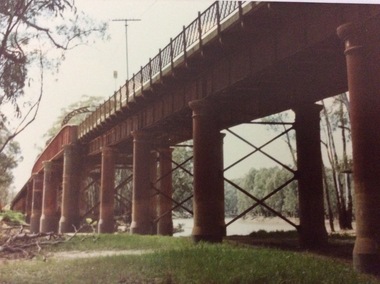 Port of Echuca
A rectangular coloured photograph, 1970?
This photograph shows the Echuca Moama bridge crossing the Murray River in the early 1970's. This photograph shows the Echuca Moama bridge in the early 1970's. It shows one of the rounded arches on the bridge. The rounded arches were the original arches and were at one stage replaced by square arches, but then replaced again by rounded arches.A rectangular coloured photograph of the Echuca Moama bridge taken from the Victorian bank, sometime in the early 1970's. One round bridge arch can be seen and a tall electricity pole can also be seen on top of the bridge. The vegetation on the Victorian bank is short and cropped. Some dead branches lie on the ground in the left foreground.There are none.echuca moama bridge, murray river, victorian bank -
Clunes Museum
Document - DOCUMENT SALE OF BRIDGE, 5.4.1877
DOCUMENT - TRANSFER OF GRUNDEMANNS BRIDGE [NOW CALLED NELSONS BRIDGE] FROM NATIONAL BANK AND MR. EVANS THOMAS TO BOROUGH OF CLUNES. DATED 23 MARCH 1877AN OFFICIAL DOCUMENT- INDENTURE BETWEEN NATIONAL BANK OF AUSTRALIA AND EVANS THOMAS OF CLUNES AND MAYOR AND COUNCILORS AND BURGEYES OF BOROUGH OF CLUNES FOR THE ABSOLUTE SALE OF BRIDGE OVER BULLAROOK CREEK IN THE BOROUGH KNOWN AS GRUNDERMANNS BRIDGE IN 1877. FOR 100. [100 POUNDS] TO CLUNES BOROUGH + COUNCILdocument, bridge - sale, bullarook creek, evan thomas, grundemanns bridge, nelsons bridge -
Glenelg Shire Council Cultural Collection
Photograph - Photograph - Bridgewater Construction, n.d
Port of Portland Authority ArchivesFront: Back- Margin ruled in pencil, diagonal in pencil. 'C' 4x2 1/4 - Pencil 'Bridgewater road bridge 29/3/57 looking s.s.w'- written in blue biro. 'Otway Street Bridge - Pencilport of portland archives, otway street bridge, bridgewater road bridge construction -
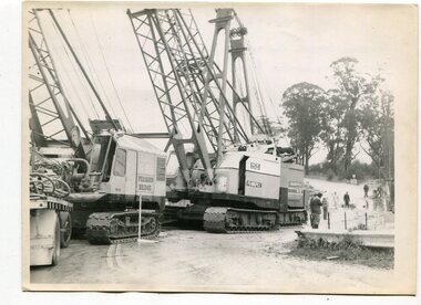 Orbost & District Historical Society
black and white photographs, 1974 - 1976
Construction of the roadway embankment between the bridges across the Snowy River flood plains at Orbost commenced in January 1974 and was completed in November 1976. Pearsons were the bridge contractors for the construction of the Princes Freeway and bridges across the river flood plains at Orbost. Heavy rains and floods held up progress.These photographs are of the construction of a major structure in Orbost. The opening of this Snowy River Bridge was an important development in the accessibility to the township of Orbost.Four black / white photographs of construction sites. 3241.1 is of three cranes and other machinery with six persons. 3241.2 is of workmen working on flooded site. 3241.3 is a photograph of the early stages of construction of a bridge looking towards the township. 3241.4 shows the construction of a roadway between the bridges.construction-snowy-river-bridge bridge-orbost -
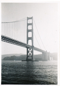 Mission to Seafarers Victoria
Photograph - Photograph, Black and White, Allan Charles Quinn, The Golden Gate (The Entrance to San Francisco Bay), 4 December 1949
This photograph is part of series depicting Allan Quinn's travels through San Francisco in 1949. This photograph shows the Golden Gate Bridge.This is a photograph from the Allan Charles Quinn collection which is a collection of letters and photograph depicting aspects of life at sea for a young man in the era immediately following World War II.A black and white photograph of the Golden Gate Bridge, in San Francisco.Reverse: 4-12-49 handwritten in blue ink, K9 /B handwritten in pencil sideways below.allan-quinn, photograph, san-francisco, golden-gate-bridge, 1949 -
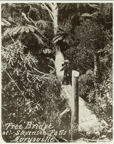 Marysville & District Historical Society
Photograph (item) - Black and white photograph, Tree Bridge at Stevenson Falls Marysville, Unknown
An early black and white photograph of a tree bridge at Steavenson Falls in Marysville in Victoria.An early black and white photograph of a tree bridge at Steavenson Falls in Marysville in Victoria. The Steavenson Falls are named after the Victorian Assistant Commissioner of Roads and Bridges, John Steavenson who arrived in Victoria in the early 1860s.tree bridge, stevenson falls, steavenson falls, waterfalls, marysville, victoria, john steavenson -
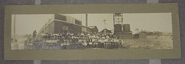 National Wool Museum
Photograph
Photograph showing panoramic view of Collins Mill, Bridge Street, Geelong, and staff.Photograph showing panoramic view of Collins Mill, Bridge Street, Geelong, and staff.This photograph was given to us when Museum of Vic was here/...and not answering by letter if he wanted it returned/ Sept 88 Allan Green/284 Shannon Ave/ NEWTOWN/ Poste Restarte (?)/Wakefield/ W. YOEKSHIRE/ ENGLANDwoollen mills - history textile industry - history textile mills - staff textile mills - history, collins bros mill pty ltd, woollen mills - history, textile industry - history, textile mills - staff, textile mills - history -
Lakes Entrance Historical Society
Book, Barned, Kim, Tambo Upper Low Level Bridge, 2003
... Bridges ...Research, interpretation and management recommendations for the Tambo Upper Low Level Bridge, East Gippsland,Victoria, by a Forestec student.bridges, waterways, natural disasters -
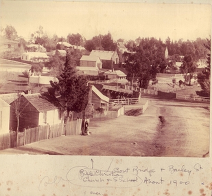 Clunes Museum
Photograph, 1900
GOVERNMENT BRIDGE AND BUILDINGS OF CLUNESSEPIA PHOTOGRAPH OF CLUNES BUILDINGS AND GOVERNMENT BRIDGE.TAKEN IN CRESWICK ROAD, SHOWING BIBLE CHRISTIAN CHURCH IN BAILEY STREET ABOUT 1900.GOVERNMENT BRIDGE AND BAILEY ST. BIBLE CHRISTIAN CHURCH AND SUNDAY SCHOOL. ABOUT 1900local history, photography, photographs, bridges and buildings -
 Phillip Island and District Historical Society Inc.
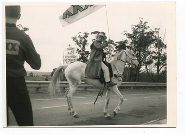
Newspaper clippings, 21/05/1938
... bridges ...Article in The Countryman 21/05/1938Article on need for a bridge to connect Phillip Island with the Mainland.local history, documents, newspapers, bridges, phillip island, black & white newspaper clipping