Showing 1795 items matching "bushfires or Black Saturday or wildfire or Ash Wednesday fires"
-
 Marysville & District Historical Society
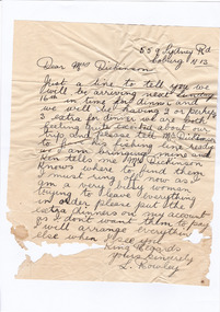
Letter (item) - Hand written letter, L. Rowley, Unknown
... 2009 black saturday bushfires... dickinson 2009 black saturday bushfires letter l. rowley A digital ...A digital copy of a hand written letter confirming the time of arrival of guests to Marysville House. Marysville House was built in the late 1920s by Arthur Dickinson.A digital copy of a hand written letter confirming the time of arrival of guests to Marysville House. Marysville House was built in the late 1920s by Arthur Dickinson.marysville, victoria, australia, marysville house, arthur james dickinson, grace dickinson, arnold spooner, eileen marie spooner, eileen marie dickinson, grace sweetland, eric dowdle, elsie may denton, elsie may dickinson, peter dickinson, linda dickinson, 2009 black saturday bushfires, letter, l. rowley -
 Marysville & District Historical Society
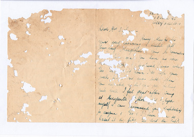
Letter (item) - Hand written letter, Unknown
... 2009 black saturday bushfires... dickinson linda dickinson 2009 black saturday bushfires letter ...A digital copy of a hand written letter thanking Mrs Dickinson for an unknown gift she sent after a couple stayed at Marysville House. Marysville House was built in the late 1920s by Arthur Dickinson.A digital copy of a hand written letter thanking Mrs Dickinson for an unknown gift she sent after a couple stayed at Marysville House. Marysville House was built in the late 1920s by Arthur Dickinson.marysville, victoria, australia, marysville house, arthur james dickinson, grace dickinson, arnold spooner, eileen marie spooner, eileen marie dickinson, grace sweetland, eric dowdle, elsie may denton, elsie may dickinson, peter dickinson, linda dickinson, 2009 black saturday bushfires, letter -
 Marysville & District Historical Society
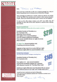
Ephemera (Item) - Accommodation voucher, KERAMI GUEST HOUSE, 2005
... 2009 black saturday bushfires... amberview cottages accommodation voucher 2009 black saturday ...An accommodation voucher which was offered to guests by Kerami Guest House for stays at the guest house or the adjoining cottages from June 2005 until July 2006.An accommodation voucher which was offered to guests by Kerami Guest House for stays at the guest house or the adjoining cottages from June 2005 until July 2006.marysville, victoria, australia, kerami guest house, amberview cottages, accommodation, voucher, 2009 black saturday bushfires -
 Marysville & District Historical Society
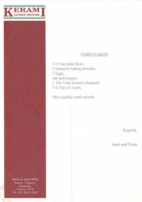
Ephemera (Item) - Recipe, Unknown
... 2009 black saturday bushfires... accommodation corn cakes recipe 2009 black saturday bushfires A recipe ...A recipe for corn cakes which was typed onto a sheet of Kerami Guest House stationary. Kerami Guest House was situated in Marysville.A recipe for corn cakes which was typed onto a sheet of Kerami Guest House stationary. Kerami Guest House was situated in Marysville.marysville, victoria, australia, kerami guest house, accommodation, corn cakes recipe, 2009 black saturday bushfires -
 Marysville & District Historical Society
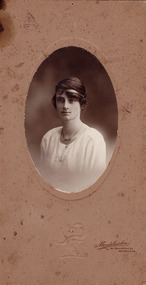
Photograph (Item) - Sepia photograph, Unknown
... 2009 black saturday bushfires... dickinson linda dickinson 2009 black saturday bushfires photograph ...A digital copy of a sepia photograph of Eilleen Dickinson Spooner, the sister of Arthur Dickinson, who build Marysville House in the late 1920s.A digital copy of a sepia photograph of Eilleen Dickinson Spooner, the sister of Arthur Dickinson, who build Marysville House in the late 1920s.Eilleen Dickinson/ Spoonermarysville, victoria, australia, marysville house, arthur james dickinson, grace dickinson, arnold spooner, eileen marie spooner, eileen marie dickinson, grace sweetland, eric dowdle, elsie may denton, elsie may dickinson, peter dickinson, linda dickinson, 2009 black saturday bushfires, photograph -
 Marysville & District Historical Society
Photograph (Item) - Black and white photograph, Unknown
... 2009 black saturday bushfires... dickinson peter dickinson linda dickinson 2009 black saturday ...A digital copy of a black and white photograph of the Dickinson Family from Marysville.A digital copy of a black and white photograph of the Dickinson Family from Marysville.marysville, victoria, australia, marysville house, arthur james dickinson, grace dickinson, arnold spooner, eileen marie spooner, eileen marie dickinson, grace sweetland, eric dowdle, elsie may denton, elsie may dickinson, peter dickinson, linda dickinson, 2009 black saturday bushfires, photograph -
 Marysville & District Historical Society
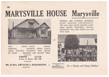
Ephemera (Item) - Accommodation booklet advertisement, Broadbent's Official Road Guides Company, MARYSVILLE HOUSE Marysville, Unknown
... 2009 black saturday bushfires... dickinson 2009 black saturday bushfires advertisement accommodation ...An advertisement for Marysville House near Marysville which was taken from a Broadbent's accommodation guide. Marysville House was built in the late 1920s by Arthur Dickinson.An advertisement for Marysville House near Marysville which was taken from a Broadbent's accommodation guide. Marysville House was built in the late 1920s by Arthur Dickinson.marysville, victoria, australia, marysville house, arthur james dickinson, grace dickinson, arnold spooner, eileen marie spooner, eileen marie dickinson, grace sweetland, eric dowdle, elsie may denton, elsie may dickinson, peter dickinson, linda dickinson, 2009 black saturday bushfires, advertisement, accommodation, broadbent's accommodation guide -
 Marysville & District Historical Society
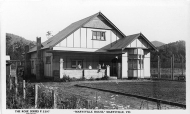
Postcard (Item) - Black and white postcard, Rose Stereograph Company, "MARYSVILLE HOUSE," MARYSVILLE, VIC, 1913-1967
... 2009 black saturday bushfires... dickinson linda dickinson 2009 black saturday bushfires rose ...A digital copy of a black and white postcard of Marysville House that was produced by the Rose Stereograph Company as a souvenir of Marysville.A digital copy of a black and white postcard of Marysville House that was produced by the Rose Stereograph Company as a souvenir of Marysville.THE ROSE SERIES P. 2297/ COPYRIGHT POST CARD The "Rose" Series/ De Luxe A Real Photograph/ Produced in Australia Published by the Rose Stereograph Co./ Armadale, Victoria. Dear Mum + Dad,/ I am coming home/ on Wednesday. I/ don't know what/ bus yet. I am coming/ home under sufference./ I know you (illegible)/ miss me an awful/ lot. (illegible) is/ sick she has/ diary. Mum I (illegible)marysville, victoria, australia, marysville house, arthur james dickinson, grace dickinson, arnold spooner, eileen marie spooner, eileen marie dickinson, grace sweetland, eric dowdle, elsie may denton, elsie may dickinson, peter dickinson, linda dickinson, 2009 black saturday bushfires, rose stereograph company, rose series, p. 2297, postcard, souvenir -
 Marysville & District Historical Society
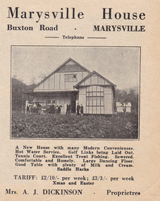
Ephemera (Item) - Accommodation booklet advertisement, Marysville House, Unknown
... 2009 black saturday bushfires... dickinson linda dickinson 2009 black saturday bushfires ...A digital copy of an advertisement for Marysville House near Marysville. Marysville House was built in the late 1920s by Arthur Dickinson.A digital copy of an advertisement for Marysville House near Marysville. Marysville House was built in the late 1920s by Arthur Dickinson.marysville, victoria, australia, marysville house, arthur james dickinson, grace dickinson, arnold spooner, eileen marie spooner, eileen marie dickinson, grace sweetland, eric dowdle, elsie may denton, elsie may dickinson, peter dickinson, linda dickinson, 2009 black saturday bushfires, advertisement -
 Marysville & District Historical Society
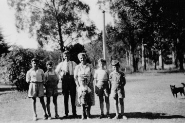
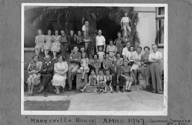
Photograph (Item) - Black and white photograph, Leonard Snowden Studios, 25-12-1947
... 2009 black saturday bushfires... dickinson peter dickinson linda dickinson 2009 black saturday ...A digital copy of a black and white photograph of a group of people staying at Marysville House taken on Christmas Day in 1947. Marysville House was build in the late 1920s by Arthur Dickinson.A digital copy of a black and white photograph of a group of people staying at Marysville House taken on Christmas Day in 1947. Marysville House was build in the late 1920s by Arthur Dickinson.marysville, victoria, australia, marysville house, arthur james dickinson, grace dickinson, arnold spooner, eileen marie spooner, eileen marie dickinson, grace sweetland, eric dowdle, elsie may denton, elsie may dickinson, peter dickinson, linda dickinson, 2009 black saturday bushfires, photograph -
 Marysville & District Historical Society
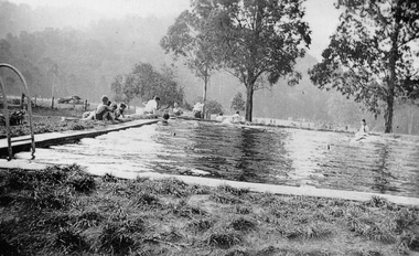
Photograph (Item) - Black and white photograph, Unknown
... 2009 black saturday bushfires... dickinson peter dickinson linda dickinson 2009 black saturday ...A digital copy of a black and white photograph of the swimming pool at Marysville House. Marysville House was built in the late 1920s by Arthur Dickinson.A digital copy of a black and white photograph of the swimming pool at Marysville House. Marysville House was built in the late 1920s by Arthur Dickinson.marysville, victoria, australia, marysville house, arthur james dickinson, grace dickinson, arnold spooner, eileen marie spooner, eileen marie dickinson, grace sweetland, eric dowdle, elsie may denton, elsie may dickinson, peter dickinson, linda dickinson, 2009 black saturday bushfires, photograph, swimming pool -
 Marysville & District Historical Society
Photograph (Item) - Black and white photograph, Unknown
... 2009 black saturday bushfires... dickinson peter dickinson linda dickinson 2009 black saturday ...A digital copy of a black and white photograph of the swimming pool at Marysville House. Marysville House was built in the late 1920s by Arthur Dickinson.A digital copy of a black and white photograph of the swimming pool at Marysville House. Marysville House was built in the late 1920s by Arthur Dickinson.marysville, victoria, australia, marysville house, arthur james dickinson, grace dickinson, arnold spooner, eileen marie spooner, eileen marie dickinson, grace sweetland, eric dowdle, elsie may denton, elsie may dickinson, peter dickinson, linda dickinson, 2009 black saturday bushfires, photograph, swimming pool -
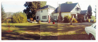 Marysville & District Historical Society
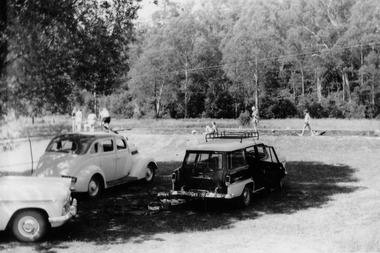
Photograph (Item) - Colour panoramic photograph, Unknown
... 2009 black saturday bushfires... dickinson 2009 black saturday bushfires photograph A digital copy ...A digital copy of a colour panoramic photograph of Marysville House. Marysville House was built in the late 1920s by Arthur Dickinson.A digital copy of a colour panoramic photograph of Marysville House. Marysville House was built in the late 1920s by Arthur Dickinson.marysville, victoria, australia, marysville house, arthur james dickinson, grace dickinson, arnold spooner, eileen marie spooner, eileen marie dickinson, grace sweetland, eric dowdle, elsie may denton, elsie may dickinson, peter dickinson, linda dickinson, 2009 black saturday bushfires, photograph -
 Marysville & District Historical Society
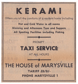
Newspaper (Item) - Newspaper advertisement, KERAMI, Unknown
... 2009 black saturday bushfires... accommodation corn cakes recipe 2009 black saturday bushfires ...A newspaper advertisement regarding Kerami Guest House in Marysville.A newspaper advertisement regarding Kerami Guest House in Marysville.marysville, victoria, australia, kerami guest house, accommodation, corn cakes recipe, 2009 black saturday bushfires -
 Marysville & District Historical Society
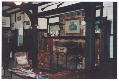
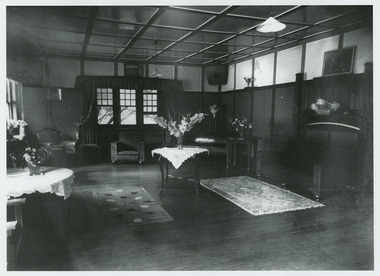
Photograph (Item) - Colour photograph, 1996
... 2009 black saturday bushfires... accommodation 2009 black saturday bushfires photograph 1996 A colour ...A colour photograph of a room in the interior of Kerami Guest House taken in 1996. Kerami Guest House was located in Marysville.A colour photograph of a room in the interior of Kerami Guest House taken in 1996. Kerami Guest House was located in Marysville.1996marysville, victoria, australia, kerami guest house, accommodation, 2009 black saturday bushfires, photograph -
 Marysville & District Historical Society
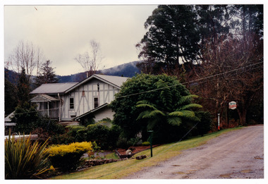
Photograph (Item) - Colour photograph, 1996
... 2009 black saturday bushfires... accommodation 2009 black saturday bushfires photograph 1996 A colour ...A colour photograph of Kerami Guest House taken in 1996. Kerami Guest House was located in Marysville.A colour photograph of Kerami Guest House taken in 1996. Kerami Guest House was located in Marysville.1996marysville, victoria, australia, kerami guest house, accommodation, 2009 black saturday bushfires, photograph -
 Marysville & District Historical Society
Photograph (Item) - Black and white photograph, Unknown
... 2009 black saturday bushfires... black saturday bushfires photograph A black and white photograph ...A black and white photograph of a room in the interior of Kerami Guest House. Kerami Guest House was located in Marysville.A black and white photograph of a room in the interior of Kerami Guest House. Kerami Guest House was located in Marysville.marysville, victoria, australia, kerami guest house, accommodation, 2009 black saturday bushfires, photograph -
 Marysville & District Historical Society
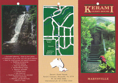
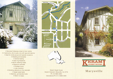
Ephemera (Item) - Information brochure, KERAMI GUEST HOUSE, Unknown
... 2009 black saturday bushfires... accommodation 2009 black saturday bushfires information brochure ...An information brochure regarding Kerami Guest House in Marysville.An information brochure regarding Kerami Guest House in Marysville.marysville, victoria, australia, kerami guest house, accommodation, 2009 black saturday bushfires, information brochure -
 Marysville & District Historical Society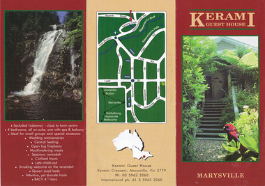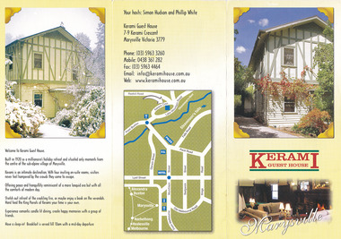
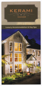
Flyer (Item) - Information flyer, Unknown
... 2009 black saturday bushfires... victoria australia kerami guest house accommodation 2009 black ...An information flyer regarding Kerami Manor in Marysville.An information flyer regarding Kerami Manor in Marysville.marysville, victoria, australia, kerami guest house, accommodation, 2009 black saturday bushfires, information flyer -
 Marysville & District Historical Society
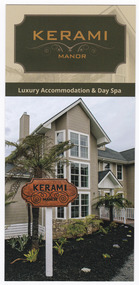
Flyer (Item) - Information flyer, Unknown
... 2009 black saturday bushfires... victoria australia kerami guest house accommodation 2009 black ...An information flyer regarding Kerami Manor in Marysville.An information flyer regarding Kerami Manor in Marysville.marysville, victoria, australia, kerami guest house, accommodation, 2009 black saturday bushfires, information flyer -
 Marysville & District Historical Society
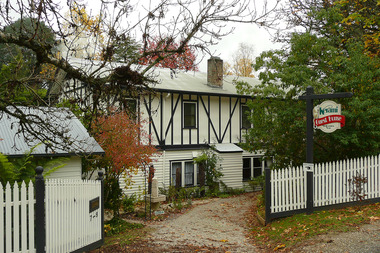
Photograph (Item) - Colour photograph, Unknown
... 2009 black saturday bushfires... house accommodation 2009 black saturday bushfires photograph ...A digital copy of a colour photograph of Kerami Guest House in Marysville.A digital copy of a colour photograph of Kerami Guest House in Marysville.marysville, victoria, australia, kerami guest house, accommodation, 2009 black saturday bushfires, photograph -
 Marysville & District Historical Society
Magazine (item) - Magazine article, Emily Friedel, Saladin's Story, 2021
... 2009 black saturday bushfires... australian cup dr peter crooke sally crooke dean crooke 2009 black ...A magazine article on the history of Saladin Lodge in Narbethong that appeared in the Murrindindi Guide of Autumn 2021.A magazine article on the history of Saladin Lodge in Narbethong that appeared in the Murrindindi Guide of Autumn 2021.narbethong, victoria, australia, saladin lodge, accommodation, events, conferences, catering, cafe, produce store, b&b accommodation, information flyer, kim rycroft, john robert crooke, aspendale racecourse, saladin, 1872 australian cup, dr peter crooke, sally crooke, dean crooke, 2009 black saturday bushfires -
 Marysville & District Historical Society
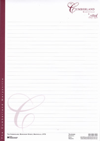
Ephemera (item) - Notepad, THE CUMBERLAND MARYSVILLE & villa day spa, Unknown
... 2009 black saturday bushfires... accommodation notepad 2009 black saturday bushfires villa day spa ...A notepad from The Cumberland guest house in Marysville. The notepad was produced for the use of guests staying at the guest house.A notepad from The Cumberland guest house in Marysville. The notepad was produced for the use of guests staying at the guest house.marysville, victoria, australia, the cumberland guest house, accommodation, notepad, 2009 black saturday bushfires, villa day spa -
 Marysville & District Historical Society
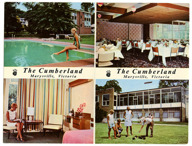
Postcard (item) - Colour postcard, The Cumberland Marysville, Victoria, Unknown
... 2009 black saturday bushfires... black saturday bushfires villa day spa postcard souvenir ...A digital copy of a colour postcard from The Cumberland guest house in Marysville.A digital copy of a colour postcard from The Cumberland guest house in Marysville.The Cumberland Marysville, Victoria Fine foods, a selection of wines, spirits, liqueurs, ales. In winter, warmth; summer, air-conditioning./ An excellent and varied menu is planned to meet the appetites sharpened by the invigorating mountain air. There are lounges to sit back in/ and enjoy the gentle art of doing nothing. Cards? A separate lounge is provided. Table Tennis? Of course. In the basement, billiards./ Outdoors there are tennis courts, bowls, croquet, and an inviting filtered pool./ At night, the soft comfort of deeply sprung beds in the privacy of your own suite; or family rooms if you wish./ Very little has been overlooked for your comfort at The Cumberland. Phone Marysville 3, or book at all leading holiday bureaux. 1428-31marysville, victoria, australia, the cumberland guest house, accommodation, 2009 black saturday bushfires, villa day spa, postcard, souvenir -
 Marysville & District Historical Society
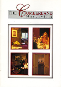
Booklet (item) - Conference booklet, THE CUMBERLAND Marysville, Unknown
... 2009 black saturday bushfires... accommodation 2009 black saturday bushfires villa day spa conference ...A digital copy of a conference booklet outlining the accommodation and facilities available at The Cumberland guest house in Marysville.A digital copy of a conference booklet outlining the accommodation and facilities available at The Cumberland guest house in Marysville.marysville, victoria, australia, the cumberland guest house, accommodation, 2009 black saturday bushfires, villa day spa, conference booklet