Showing 1588 items
matching farming.
-
 Department of Energy, Environment and Climate Action
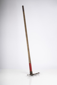
Rakehoe (McLeod Tool)
Bushfire perimeter rather than bushfire area is the main control problem for firefighters on the ground. A conundrum rapidly compounded by spot fires. A small 5 ha fire can be nearly 1 km around the perimeter. That's a long way to build a control line by hand in rough bush. Dry firefighting techniques by hand were mostly confined to “knocking down” or “beating out” the flames, as well as "digging out". Digging or raking a “mineral earth” trail down to bare dirt proved most effective in forest fuels which, unlike grass, tend to retain heat and smoulder. Early tools were whatever happened to be close at hand. They were simple and primitive and included shovels, slashers, axes, hoes, beaters and rakes. A cut branch to beat the flames was often the only thing available. Farming and logging tools, developed over centuries of manual labour, and readily available at local hardware stores came into use, but little thought was given to size, weight, and balance. For years foresters experimented with combination tools. In about 1952 fire beaters and other implements were being replaced with Rakuts. However, its believed the now common Rakehoe is an Australian variation of the American McLeod Tool which was developed in 1905 by forest ranger Malcolm McLeod of the Sierra National Forest. The late Athol Hodgson advised that predecessors, Reg Torbet who had been the Chief Fire Officer for the Forests Commission from 1948-1956, along with his QLD counterpart Clive Price, went in late 1951 as Australian delegates on a 10 week fire study tour of Nth America organised by the United Nations. They came back with a couple of McLeod tools from Canada. Cam MacLeod (different spelling) had been the Head of Fire Research for the Canadian Forest Service at the time and had supplied them. The tools were ideal for deciduous forests in the eastern provinces and Clive arranged to have them manufactured in QLD. The Rakho, as it was then spelled, was first issued to FCV crews 65 years ago in 1955-56. The American Pulaski had been trialled, but never found favour with Australian firefighters.Rakhoeforests commission victoria (fcv), hand tools, forest harvesting, bushfire -
 Department of Energy, Environment and Climate Action
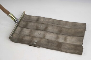
Fire beater (canvas)
Bushfire perimeter rather than bushfire area is the main control problem for firefighters on the ground. A conundrum rapidly compounded by spot fires. A small 5 ha fire can be nearly 1 km around the perimeter. That's a long way to build a control line by hand in rough bush. Dry firefighting techniques by hand were mostly confined to “knocking down” or “beating out” the flames, as well as "digging out". Digging or raking a “mineral earth” trail down to bare dirt proved most effective in forest fuels which, unlike grass, tend to retain heat and smoulder. Early tools were whatever happened to be close at hand. They were simple and primitive and included shovels, slashers, axes, hoes, beaters and rakes. A cut branch to beat the flames was often the only thing available. Farming and logging tools, developed over centuries of manual labour, and readily available at local hardware stores came into use, but little thought was given to size, weight, and balance. For years foresters experimented with combination tools. In about 1952 fire beaters and other implements were being replaced with Rakuts. However, its believed the now common Rakehoe is an Australian variation of the American McLeod Tool which was developed in 1905 by forest ranger Malcolm McLeod of the Sierra National Forest. The late Athol Hodgson advised that predecessors, Reg Torbet who had been the Chief Fire Officer for the Forests Commission from 1948-1956, along with his QLD counterpart Clive Price, went in late 1951 as Australian delegates on a 10 week fire study tour of Nth America organised by the United Nations. They came back with a couple of McLeod tools from Canada. Cam MacLeod (different spelling) had been the Head of Fire Research for the Canadian Forest Service at the time and had supplied them. The tools were ideal for deciduous forests in the eastern provinces and Clive arranged to have them manufactured in QLD. The Rakho, as it was then spelled, was first issued to FCV crews 65 years ago in 1955-56. The American Pulaski had been trialled, but never found favour with Australian firefighters.Fire Beater (canvas) 1930s designforests commission victoria (fcv), hand tools, forest harvesting, bushfire -
 Department of Energy, Environment and Climate Action
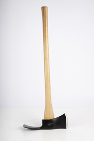
Pulaski
Bushfire perimeter rather than bushfire area is the main control problem for firefighters on the ground. A conundrum rapidly compounded by spot fires. A small 5 ha fire can be nearly 1 km around the perimeter. That's a long way to build a control line by hand in rough bush. Dry firefighting techniques by hand were mostly confined to “knocking down” or “beating out” the flames, as well as "digging out". Digging or raking a “mineral earth” trail down to bare dirt proved most effective in forest fuels which, unlike grass, tend to retain heat and smoulder. Early tools were whatever happened to be close at hand. They were simple and primitive and included shovels, slashers, axes, hoes, beaters and rakes. A cut branch to beat the flames was often the only thing available. Farming and logging tools, developed over centuries of manual labour, and readily available at local hardware stores came into use, but little thought was given to size, weight, and balance. For years foresters experimented with combination tools. In about 1952 fire beaters and other implements were being replaced with Rakuts. However, its believed the now common Rakehoe is an Australian variation of the American McLeod Tool which was developed in 1905 by forest ranger Malcolm McLeod of the Sierra National Forest. The late Athol Hodgson advised that predecessors, Reg Torbet who had been the Chief Fire Officer for the Forests Commission from 1948-1956, along with his QLD counterpart Clive Price, went in late 1951 as Australian delegates on a 10 week fire study tour of Nth America organised by the United Nations. They came back with a couple of McLeod tools from Canada. Cam MacLeod (different spelling) had been the Head of Fire Research for the Canadian Forest Service at the time and had supplied them. The tools were ideal for deciduous forests in the eastern provinces and Clive arranged to have them manufactured in QLD. The Rakho, as it was then spelled, was first issued to FCV crews 65 years ago in 1955-56. The American Pulaski had been trialled, but never found favour with Australian firefighters.Pulaski Fire Tool Combines an axe and a grubbing hoe. Digging end and cutting end with short wooden handleforests commission victoria (fcv), hand tools, forest harvesting, bushfire -
 Forests Commission Retired Personnel Association (FCRPA)
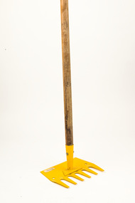
Rakehoe, McLeod Tool (American)
Bushfire perimeter rather than bushfire area is the main control problem for firefighters on the ground. A conundrum rapidly compounded by spot fires. A small 5 ha fire can be nearly 1 km around the perimeter. That's a long way to build a control line by hand in rough bush. Dry firefighting techniques by hand were mostly confined to “knocking down” or “beating out” the flames, as well as "digging out". Digging or raking a “mineral earth” trail down to bare dirt proved most effective in forest fuels which, unlike grass, tend to retain heat and smoulder. Early tools were whatever happened to be close at hand. They were simple and primitive and included shovels, slashers, axes, hoes, beaters and rakes. A cut branch to beat the flames was often the only thing available. Farming and logging tools, developed over centuries of manual labour, and readily available at local hardware stores came into use, but little thought was given to size, weight, and balance. For years foresters experimented with combination tools. In about 1952 fire beaters and other implements were being replaced with Rakuts. However, its believed the now common Rakehoe is an Australian variation of the American McLeod Tool which was developed in 1905 by forest ranger Malcolm McLeod of the Sierra National Forest. The late Athol Hodgson advised that predecessors, Reg Torbet who had been the Chief Fire Officer for the Forests Commission from 1948-1956, along with his QLD counterpart Clive Price, went in late 1951 as Australian delegates on a 10 week fire study tour of Nth America organised by the United Nations. They came back with a couple of McLeod tools from Canada. Cam MacLeod (different spelling) had been the Head of Fire Research for the Canadian Forest Service at the time and had supplied them. The tools were ideal for deciduous forests in the eastern provinces and Clive arranged to have them manufactured in QLD. The Rakho, as it was then spelled, was first issued to FCV crews 65 years ago in 1955-56. The American Pulaski had been trialled, but never found favour with Australian firefighters.First used in 1955Rakehoe Combination of a heavy-duty six-toothed (each 9cm long) rake with a large, sturdy (25cm) hoe.bushfire, forests commission victoria (fcv) -
 Eltham District Historical Society Inc
Photograph - Digital Photograph, Alan King, Original Kangaroo Ground Primary School No. 2105 building, Eltham-Yarra Glen Road, Kangaroo Ground, 28 December 2007
Kangaroo Ground's first school began in 1851 with 22 pupils from the district's ten families. It was a single room school located further south on the site, which also served as a Presbyterian church. The first teacher was Andrew Ross. The school building was used as a Post Office between 1854 and 1858 and during 1857 also served as a Court of Petty Sessions. With a growing farming community, a new building was warranted and the original Sate School No. 352 was closed and a new building, State School No. 2105 was oipened October 1, 1878. A residence for Head Teacher Henry Wallace School was erected in 1879 attached to the left of the school building. That residence is now home to the Andrew Ross Museum, which opened in 1993. Covered under Heritage Overlay, Nillumbik Planning Scheme. Published: Nillumbik Now and Then / Marguerite Marshall 2008; photographs Alan King with Marguerite Marshall.; p35 In a corner of the Kangaroo Ground Primary School playground stands an old weatherboard building. This structure, attached to the former teacher’s weatherboard residence facing Main Road, first served as a school in 1878. The former residence, built in 1879, houses the Andrew Ross Museum, which opened in 1993. It is named after the school’s first teacher,1 who also founded The Evelyn Observer newspaper, which began on the site in 1873. Later the printing presses were moved to brick newspaper offices by the Kangaroo Ground Hotel, which became the Shire of Eltham offices. However Kangaroo Ground’s first school began in 1851 for 22 pupils from the district’s ten families, in a slab building further south on this site. Andrew Harkness and other settlers campaigned for the building, which was built on half an acre (0.2ha) donated by local farmer, James Donaldson. Builder was Samuel Furphy, father of the novelist Joseph.2 The single room measuring 30 feet x 18 feet (9m x 5.5m), was unlined and the green slabs shrank, allowing the wind and rain entry through cracks except when they were stuffed with paper.3 The building served as a Presbyterian church as well as a school, where fees were 18 pence a week for education. Young men also attended evening classes there in winter. At one stage, a corner of the room was curtained off for the schoolmaster’s living space, and the platform, which was used for sleeping, was also the pulpit during church services. Teacher Andrew Ross also took church services when the minister was unable to attend, which happened frequently as he had long distances to travel on the bad roads. In 1857 the school building was also used as the Court of Petty Sessions, and from 1854 until 1858, it served as a post office. During the gold rush fossickers on their way to the Caledonia Diggings at Queenstown (now St Andrews) prospected the district, but did not remain long, as the fields were not rich in gold. But the farming community grew, until by 1878 the population warranted the building of State School No 2105 – the present one-roomed tongue-and-groove lined building measuring 49 feet x 18 feet (15m x 5.5m), to accommodate 60 children. The old school, No 352, was closed, and the new one opened on October 1, with Henry Wallace as head teacher, assisted by work mistress Annie Johnston. Early teachers included Messrs Smith, Hamilton and Prosser, with sewing teachers Misses Sweeney, Limerock and Oliver. In the early 1920s a small room was built on the front veranda of the teacher’s residence, and used as a State Savings Bank agency until about 1934. In 1928 the schoolroom’s three-tiered floor was replaced by a flat floor and teacher’s platform (which has since been removed). A half-glassed partition wall then divided the large room into two rooms in which the old style form-type desks were replaced with dual desks. The small playground, surrounded by pine trees and a picket fence, was extended in 1931 with an additional acre or so (0.4 ha) of land. During World War Two the school faced closure because of a fall to seven in the enrolment, but by 1946 it had increased again to 45. Mr Eric Morgan was head teacher and Mrs Margaret Banks was assistant head teacher, a position she held for ten years. In 1955, under the head teacher Mr V Gardiner, who taught there for 13 years, the school won a prize for the best-kept garden and school ground in the inspectorate. A district subdivision increased the enrolment in 1968 to 65 and a bus service was established. After the hall which had been used for lessons was demolished late that year, the pupils met in the original fire brigade meeting room (now the tennis club, diagonally opposite the general store). The new school building with a storeroom and staffroom was built in 1974.This collection of almost 130 photos about places and people within the Shire of Nillumbik, an urban and rural municipality in Melbourne's north, contributes to an understanding of the history of the Shire. Published in 2008 immediately prior to the Black Saturday bushfires of February 7, 2009, it documents sites that were impacted, and in some cases destroyed by the fires. It includes photographs taken especially for the publication, creating a unique time capsule representing the Shire in the early 21st century. It remains the most recent comprehenesive publication devoted to the Shire's history connecting local residents to the past. nillumbik now and then (marshall-king) collection, kangaroo ground, andrew ross museum, eltham-yarra glen road, kangaroo ground primary school no. 2105, kangaroo ground state school, state school no. 2105 -
 The Beechworth Burke Museum
Audio - Oral History, Jennifer Williams, Max Suter, 29 June 2000
Mr Max Sutor was born in South Australia. He first began his work as a marine engineer at the Mildura Irrigation Trusts, moving later to the Melbourne Harbour Trusts. After a number of years as an engineer, he moved into farming at Gippsland and joined the prison service several years after during the late 1960s. He was first stationed at Morwell River Prison in South Gippsland, transferring to McLeod Prison in 1972 and finally to Beechworth in 1974 as senior prison and stores officer. He would assist in the organisation, obtaining and distribution of food and medication to prisoners. The prison, at the time, was of medium security and held high security prisoners, with an estimated amount of 108 prisoners to 23 staff. Mr Suter showed a great push in showing humility towards prisoners, wanting to avoid animosity against them by never looking at their records to treat them equally. His choice of kind behaviour towards prisoners had clearly influenced their own, especially during manual labor. The prison had worked cooperatively with a local farm, having their prisoners assist in the farm work. Attitudes inevitably changed positively for several prisoners. Whilst he held no control over their actions at the farm, he still became well trusted and liked amongst the prisoners, as they would continue to go to him for assistance and questions. Mr Suter had also worked as an instigator of finding drugs within each prison he has worked within. This led him to study the variations, and being a member of the Parents and Citizens Association at the high school his children attended, as well as Community Service Director of a Rotary club, he wanted to educate parents in guidance for those unsure on how to conduct actions against such behaviours. From his first seminar, a police surgeon told him that three drug users were found by their parents. This oral history recording was part of a project conducted by Jennifer Williams in the year 2000 to capture the everyday life and struggles in Beechworth during the twentieth century. This project involved recording seventy oral histories on cassette tapes of local Beechworth residents which were then published in a book titled: Listen to what they say: voices of twentieth century Beechworth. These cassette tapes were digitised in July 2021 with funds made available by the Friends of the Burke.Mr Max Suter's account on his time and experience as a senior prison officer at Beechworth Prison is historically and socially significant for the cultural heritage of the region. His recounts of his time working within the prison and out in local parent and community associations held a positive effect on the awareness and behaviours of the Beechworth area, and provides detailed information on the duties and complications working in a 20th century rural prison, as well as the lack of local awareness from adults with young influential children. This oral history account is socially and historically significant as it is a part of a broader collection of interviews conducted by Jennifer Williams which were published in the book 'Listen to what they say: voices of twentieth-century Beechworth.' While the township of Beechworth is known for its history as a gold rush town, these accounts provide a unique insight into the day-to-day life of the town's residents during the 20th century, many of which will have now been lost if they had not been preserved.This is a digital copy of a recording that was originally captured on a cassette tape. The cassette tape is black with a horizontal white strip and is currently stored in a clear flat plastic rectangular container. It holds up 40 minutes of recordings on each side.Max Suterlisten to what they say, beechworth, oral history, burke museum, max suter, beechworth prison, farming, drug awareness -
 Melton City Libraries
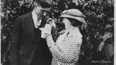
Photograph, Tom and May Barrie, 1935
Ferris Road–Ferris Lane family farm of John and Elizabeth Ferris until 1939, until daughter Marion married Thomas Linsday Barrie. Marion Elizabeth nee Ferris born 29th of August 1914 -died 5th of June 1990 SUMMARY - Thomas Lindsay Barrie 1914 – 1990 A life long resident of Melton Son of Jessie and Charles Ernest Barrie of Darlingsford Melton Married Marion Ferris at Christ Church Melton on 11th May 1939. They lived on the family farm at Ferris Road Melton. They had one son, Ian who has continued in farming in Melton. He served the community in the following – Shire of Melton Councillor Member for 32 years 1941 – 1970 Elected as Councillor for Melton South 1970 – 1973 Councillor for Rockbank 1943 – 1944 Shire President for three terms 1958 – 1959 ditto 1964 – 1965 ditto Council Representative: Bacchus Marsh High School and Western Suburbs Municipalities. Representative on delegation to prevent Melton post primary students being sent to Deer Park prior to the establishment of Melton High School. Melton Bush Fire Brigade 1941 Member Melton Bush Fire Brigade Registered No. 425 1942 1942 2nd Lieutenant 1943 – 1944 4th Lieutenant Country Fire Authority Rural Services Award 1963 20 Years Long Service Badge Scots Presbyterian Church Melton Member of the Board of Management 1947 – 1969 information from Annual Reports note more research needed at Uniting Church Archives Tom farmed the family property with his father and brothers, and later the Ferris Road property which continued with his son Ian. His childhood interest in horses began with the draft horses kept at the bluestone stable and barn at Darlingsford. When the stables were empty in the late 1980s visit, he vividly recalled the names of the horses he had handled in his youth. When the draft horse became obsolete with the introduction of tractors and trucks this interest continued with the breeding and training of harness racers. Darlingsford Drafts and Ponies. Order of Stalls Clydesdales – Dick, Dolly, Flower, Nugget, Blossom, Lofty, Prince. Roger, Rose, Violet, Don, Beauty, Baldy, Diamond. Cart and Mounts Creamy, Digger, Popsy Couple at Francis McGregor Barrie and Linda Willaton's wedding at Sunshine Methodist Church 20th April 1935?local identities -
 Flagstaff Hill Maritime Museum and Village
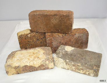
Ceramic - Clay Bricks, Circa 1838
These bricks are a sample of “5000 house bricks from London” carried by the CHILDREN as ballast, and intended for the Portland Bay settlement of her owners Henty Bros. Flagstaff Hill divers recovered them from Childers Cove in February 1974, and noted, “These bricks are the major feature of the wreck site. Subsequent notes indicate “The hull structure has broken up, leaving few visible remains, except for piles of house bricks intended for the Hentys of Portland”. According to Lloyds Shipping Register 1837-1839, the CHILDREN was built in 1825 at Liverpool and operated by owners Gordon & Co, of London, London registered number 123/1837; James Henty then bought her in 1837 as a three-masted barque of 254 tons, with a hull of “part pitch pine, felt sheathed” and “coppered 1837”. Launceston registered number 6/1837; in 1838 the CHILDREN, under her master Captain H. Browne, completed a successful round trip from Launceston to London (carrying wool and whale oil loaded in Portland), returning in late November of that year (carrying general cargo including the house bricks). On the 11th of January 1839, the CHILDREN sailed from Launceston for Adelaide, with 24 passengers, 14 crew, and an awkward mixed cargo, including 1500 sheep, 8 bullocks, 7 horses, and farming implements, and six whaleboats with associated whaling gear. One account states that when the CHILDREN “put out from port she was light and badly ballasted”. The vessel immediately encountered four days of hurricane-force storms, eventually clearing on the early morning of the 14th to “west force 10”, but too late to take accurate measurements of the sun or stars to establish their position relative to the coast. The CHILDREN collided with a limestone stack at the entrance of Childers Cove, and the seas smashed her into pieces within half an hour. All the cargo and 16 lives were lost (including 8 children). The Hentys contributed £150 towards a fund for the 22 survivors at a memorial service held in Launceston later that year. It was a major financial setback for the Hentys, but one from which they recovered. In a submission to the Governor of New South Wales dated 24 March 1840, the Hentys summarised their work over the previous six years of settlement: “Six stations have been occupied, one at Portland Bay…three at the open country about 60 miles inland called ‘Merino Downs’…They have erected two houses at Portland Bay and two others at Merino Downs”.These bricks are significant as a sample of 5000 house bricks carried from London as ballast by the Children and were intended for the Portland Bay settlement of her owners James Henty & Co. The CHILDREN was one of the first vessels to be lost in the Western District of Victoria, east of Warrnambool, on January 14th 1838, breaking up within twenty minutes. The wreck is also significant as one of the first vessels to have been lost in the Western District of Warrnambool and as such is registered on the Victorian Heritage Register S116.Five ‘house bricks from London’, some with white marine encrustation, recovered from the wreck of the ship CHILDREN. The bricks are oblong shaped and constructed of a blue-coloured and coarse-grained conglomerate. One brick is higher, shorter and narrower, than the other four bricks.Nonewarrnambool, shipwreck coast, flagstaff hill, shipwrecked coast, flagstaff hill maritime village, flagstaff hill maritime museum, shipwreck artefact, maritime museum, london house bricks, children shipwreck, james henty and co, henty brothers, childers cove, early shipowreck -
 8th/13th Victorian Mounted Rifles Regimental Collection
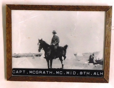
Photograph - McGrath, 1918 circa
William 'Lauchie' McGrath, an accountant with Australian Mercantile Land & Finance (AML&F), enlisted in AIF in September 1914. He was posted to 8th Light Horse regiment with the No 268 and rank of trooper. He rose through the ranks, serving at Gallipoli, Egypt and Palestine reachin the rank of Captain/Adjutant of the regiment. The 8th Light Horse Regiment AIF was raised at Broadmeadows Victoria in September 1914 under the command of Lieutenant Colonel Alexander White and formed part of the 3rd Light Horse Brigade. The regiment served at Gallipoli where in a courageous but ill-fated charge at the Nek on 7 August 1915 it suffered horrendous casualties including Lieutenant Colonel White. Rebuilt in Egypt under the command of Lieutenant Colonel Leslie Maygar VC the regiment went on the serve throughout the Middle East Campaign. Colonel Maygar died of wounds at Beersheba when the regiment was attacked by enemy aircraft while waiting to follow up the successful charge of the 4th LH Brigade on 30 October 1917. The 8th Light Horse AIF was disbanded in 1919, but soon after re-raised as the 8th (Indi) Light Horse in the Citizen Military Forces, superseding 16th (Indi) Light Horse. McGrath wrote the History of the regiment (See 3091.901) Following his return to Australia he took up farming in the Upper Murray, On 10 February 1924, a community picnic was being held at a creek below his Jingellic homestead when a maniac armed with a rifle came out of the scrub and proceeded to shoot indiscriminately int the party. No reason was ever given but it was presumed that he wanted to kill one man who was not among the five he hit. McGrath got the women and children into the creek and organised the other wounded - he had already been hit in the chest - into cover before running over open ground for his rifle in the house. In all he stopped five bullets but the gunman bolted once McGrath appeared with his own weapon.Some weeks later he was captured getting milk from a dairy and declared insane. One of the five victims died that day, one some months later, one had to use a stick for the rest of his life and McGrath was forced to give up the farm and return to his old job as an accountant. He was awarded the silver medal of the Royal Humane Society of NSW and the silver medal of the Royal Shipwreck Relief & Humane Society of NSW. The latter body felt the water in the creek made it appropriate to also make the award. McGrath enlisted again in World War Two, serving firstly as 2/ic Broadmeadows Camp and later 2/ic the Officer Commanding 12th Garrison Battalion. Framed black and white photograph of mounted officer with tents in background.Across lower edge of frame "Capt. McGrath. MC.. MID. 8th Australian Light Horse"mcgrath, 8th, light horse, garrison, royal humane society nsw -
 Melton City Libraries
Document, West Melton: A preview of tomorrow, c.1969
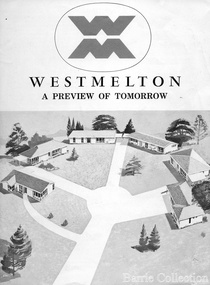
"In April 1969, the first major residential development in Melton began with the release of 148 homes for purchase. This was the first stage of a staggered release of a planned 30,000 homes for 100,000 people by 1990. The development, called Westmelton Satellite City, was described as ‘a preview of tomorrow’.101 It was the first estate built in a ‘modern’ style, with curved streets, and dozens of culs de sac. Westmelton was also the first major development in Victoria to build all the supply lines to the houses – including electricity and telephone lines – underground. The six different home designs in Westmelton were ‘specially designed for the future’, and with allotments ten feet wider than regulations required, there was plenty of ‘space for gracious living’ and for a family swimming pool. The developers of this new estate were active in promoting Westmelton as a new community within the Shire of Melton. By 1971, the Westmelton City News reported that Ian McIntosh, General Manager of Westmelton, had given away $100,000 on behalf of the company ‘to aid community projects’. This included a $72,000 donation towards building a community centre in Westmelton, and $25,000 for the shire’s Olympic-sized swimming pool. Ian McIntosh and his family moved to Melton and Ian said he was ‘very much aware of the needs of [the] Westmelton community’. By the end of 1971, Westmelton was home to 100 new families. The modern residences were obviously an appealing drawcard, but so was the country feel that characterised Melton. Mrs C. Allen, described as a ‘housewife’, said she and her husband chose to move to Westmelton because of ‘the quality homes ... and we both love the clean, fresh, natural environment that surrounds us’. Similarly, Mr W. Coxhead, insurance consultant, moved to Westmelton because of the ‘clean, fresh country air’. Accountant Mr B. Swanton echoed their sentiments, describing Westmelton as ‘far enough away from the industrial pollution carried over Melbourne suburbs by prevailing westerly winds’. The new development attracted an increasing number of young, professional couples and families, representing the beginning of a significant shift from the predominantly rural and farming community of the district’s past. The Westmelton development had four different ‘neighbourhoods’ designed to cater to a variety of different lifestyle needs. Westmelton was the first to be established, followed by Brookfield, which offered ‘superb land in a rustic setting’. Brookfield Acres offered ‘wide open spaces with lots of room for a pool and even a tennis court’ on huge one-acre blocks, while Westlake was an innovative development with ‘different sized homesites’ and ‘lakeside living’.Westmelton was the first of many residential developments that would come to play a huge role in shaping the shire in the decades to follow".A marketing brochure for the Westmelton Satellite City developmentlocal significant events, council -
 Wodonga & District Historical Society Inc
Furniture - Secretaire with Bookcase - the Watson Family of Wodonga
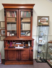
This secretaire once stood proudly in the de Kerilleau homestead at Wodonga. The homestead had been built for William Huon, son of the early pastoralist Paul Huon, in 1870 and named after the family's ancestral estate in France. The original lease of the Wodonga Run was granted to Paul Huon as No. 202 on 7th February 1837, about a year after his cousin Charles Huon had squatted on the land. Kenneth Darnton Watson bought de Kerilleau homestead in 1922 where the Watson family lived for three generations, caring for the land and serving the Wodonga community. Kenneth, his son Ian Darnton Watson and his grandson John Kenneth Darnton Watson all served on the Wodonga Council. John Kenneth Darnton Watson was born on 28 August 1960 in Wodonga. After completing his primary schooling locally, he boarded at Geelong College from 1973. John joined the rowing crews, starting in the 8th VIII crew and reaching the 1st VIII crew in 1978. He received multiple House colours awards for cross country, athletics and rowing and received School colours for rowing. On completion of his schooling, John spent some time jackarooing before studying farm management at Marcus Oldham College. He then returned home to de Kerilleau, Wodonga to manage the family property. In 1984 John married Christine Honybun, daughter of David Lewis Honybun and Marian Josephine Edkins. John and Christine had three sons. John was community minded and involved in a number of local organisations such as Apex and agricultural societies. He was elected to Wodonga City Council in 1997, serving until 2004. Due to increased pressure on available land to cater for the growth of Wodonga, some of the property was sold and in 2003 John donated 200 ha of Huon Hill ‘s western slopes to the City of Wodonga. After this time, he moved away from farming to become a Hungry Jack's franchisee. In 2009, the hard decision was made to sell de Kerilleau and John and his family moved into Wodonga. After sadly losing Christine to cancer in 2017, John became a member and Deputy Chairperson of the Albury Wodonga Regional Cancer Centre Trust Fund Board and Ambassador for the Sunshine Walk. Tragically after his own cancer battle, John Kenneth Darnton Watson passed away on 24 August 2023, aged 62 years following a life of service to the Wodonga community.This item is significant because it was owned by a prominent Wodonga family and came from a Historic Homestead in WodongaA secretaire with bookcase made of cedar. The bottom section has two cupboards with shelves. These doors support the desk when it is fully opened. Above this section is one large drawer, the front of which opens by pressing a small internal button on each side. The open drawer reveals a desk with a leather writing mat and several compartments. The desk is topped by a book shelf with 3 adjustable shelves. It has lockable glass doors.watson family wodonga, de kerilleau homestead, john watson -
 Wodonga & District Historical Society Inc
Decorative object - Silver Tray from John Kenneth Darnton Watson, Wodonga
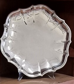
This silver tray was donated by the family of John Watson and was used when they lived in de Kerilleau Homestead for three generations. de Kerilleau Homestead was built for William Huon, son of the early pastoralist Paul Huon, in 1870 and named after the family's ancestral estate in France. The original lease of the Wodonga Run was granted to Paul Huon as No. 202 on 7th February 1837, about a year after his cousin Charles Huon had squatted on the land. Kenneth Darnton Watson bought de Kerilleau homestead in 1922 where the Watson family lived for three generations, caring for the land and serving the Wodonga community. Kenneth, his son Ian Darnton Watson and his grandson John Kenneth Darnton Watson all served on the Wodonga Council. John Kenneth Darnton Watson was born on 28 August 1960 in Wodonga. After completing his primary schooling locally, he boarded at Geelong College from 1973. John joined the rowing crews, starting in the 8th VIII crew and reaching the 1st VIII crew in 1978. He received multiple House colours awards for cross country, athletics and rowing and received School colours for rowing. On completion of his schooling, John spent some time jackarooing before studying farm management at Marcus Oldham College in Geelong, Victoria. He then returned home to de Kerilleau, Wodonga to manage the family property. In 1984 John married Christine Honybun, daughter of David Lewis Honybun and Marian Josephine Edkins. John and Christine had three sons. John was community minded and involved in a number of local organisations such as Apex and agricultural societies. He was elected to Wodonga City Council in 1997, serving until 2004. Due to increased pressure on available land to cater for the growth of Wodonga, some of the property was sold and in 2003 John donated 200 ha of Huon Hill‘s western slopes to the City of Wodonga. After this time, he moved away from farming to become a Hungry Jack's franchisee. In 2009, the hard decision was made to sell de Kerilleau and John and his family moved into Wodonga. After sadly losing Christine to cancer in 2017, John became a member and Deputy Chairperson of the Albury Wodonga Regional Cancer Centre Trust Fund Board and Ambassador for the Sunshine Walk. Tragically after his own cancer battle, John Kenneth Darnton Watson passed away on 24 August 2023, aged 62 years following a life of service to the Wodonga community.This item is significant because it was owned by a prominent Wodonga family and came from a Historic Homestead in WodongaA circular silver tray with an embossed design around the outer edge.watson family wodonga, de kerilleau homestead, john watson, peter charlesworth -
 Melton City Libraries
Photograph, Charles Ernest Barrie and family, 1906
Photograph was taken on the 23rd of August 1906, the day of Jessie May Lang and Charles Ernest Barrie's wedding. Held at the Methodist Church Melton. UMMARY – Charles Ernest Barrie d.1931 Born 1871 Ballarat d 1931 This document is has been compiled by Wendy Barrie daughter of Ernest (Bon) and Edna Barrie and granddaughter of Charles E and Jessie M Barrie. My grandfather was well known in the district and was mostly referred to as Ernie. He shared the same initials as his second son Edgar. His three eldest sons lived and farmed in Melton for their entire lives. His descendants are still associated with farming, engineering and earthmoving in Melton. Ernie Barrie operated a travelling Chaff Cutter in the St Arnaud area where his parents William and Mary Ann had taken up land at Coonooer West in 1873. Ernie commenced his working life with a team of bullocks and a chaff cutter. The earliest connection he had with Melton was in 1887. By the beginning of the 20th century Ernie and his father William and brothers, William, Samuel, James Edwin,[Ted] Robert, Arthur and Albert have been associated with farming and milling in the Melton district. In the early 1900’s Ernie and his brother Ted were in partnership in a Chaff cutting and Hay processing Mill on the corner of Station and Brooklyn road Melton South. The mill was managed by William for a time. By 1906 Charles Ernest and James Edwin were in partnership in the Station Road mill when a connecting rail line across Brooklyn Road for a siding was constructed to the Melton Railway Station. In 1911 the Mill’s letterhead shows C.E. BARRIE Hay Pressing and Chaff Cutting Mills. Melton Railway Station. Telephone No 1 Melton. This Mill as sold to H S K Ward in 1916 and stood until 1977 when it burnt down in a spectacular fire. Ernie built a house at Melton South beside the Chaff Mill at Station Road in 1906 and married Jessie May Lang in August at the Methodist Church. Jessie’s father was Thomas Lang. He came to Melton in 1896 and was the Head Teacher at Melton State School No 430 until he retired in 1917. They had 9 children with 8 surviving to adulthood. Jessie and Ernie had 6 sons and 3 daughters. All the children lived at Darlingsford. In April 1910 the family left Melton for a brief period and moved to a farm in Trundle in NSW. They returned to Melton and purchased Darlingsford in May 1911. For a time during WW1 they lived at Moonee Ponds near the Lang grandparents at Ascot Vale. Mary and Bon attended Bank St State School. The children developed diphtheria in 1916 and their youngest boy, Cecil died of complications. Mary and Bon were taken to Fairfield Hospital and both recovered. At the end of the war influenza broke out the family returned to Darlingsford and shared the home for a short while with the Pearcey family who had been working the farm. By 1922 the family had and grown and Edgar, Tom, Horace, Jessie, Joyce and Jim were living a Darlingsford. Ernie continued during the 1920’s working the farm and attend his many civic and community commitments. Two 8 clydesdale horse teams were used to work the land which meant early rising for the horses to be fed and harnessed to commence the days work. In 1916 Ernie also became involved in a Chaff Mill on the corner of Sunshine and Geelong Road West Footscray, which at the time was being run by John Ralph Schutt. It was known an Schutt Barrie. A flour mill was added at a later stage. Other Schutt and Barrie mills were situated at Parwan and Diggers Rest. Another mill was situated beside the railway line at Rockbank. The Footscray mill ceased operation in 1968. Ernie spent a lot of time and energy at the Parwan Mill and travelling around Parwan and Balliang farms, where he came to know many of the families in the district. Ernies commitment to the civic development to the Melton and district was extensive, he was involved with a number of large events during the 1920’s such as the Melton Exhibitions and the 1929 Back to Melton Celebrations. He was a member of the Australian Natives Association at the turn of the century. He was Chairman of the School Committee at Melton State School 430 and the Melton South State School in thw1920s. He donated the land for a Hall for Melton South in 1909, known as Exford Hall and later in 1919 renamed Victoria Hall. The Hall was demolished in 1992. He was a Councillor, JP, and Vice President and President of the Melton Mechanics Institute Hall Committee in 1915- 1916. He was a member of the Methodist Church and later the Scots Presbyterian Church. He was Superintendent of the Sunday School of the Methodist Church to 1910 and later Scots Presbyterian Church until 1931. This is reflected in the theme of children in the stained glass window which was dedicated in his memory by his wife Jessie as a gift to the Scots Church. Charles Ernest Barrie made many generous donations to many charities who supported young people and children. In 1918 Jessie and Ernie made the first donation to a very prominent Victorian charity whose work still continues. Yooralla. In July 1931 Ernie’s untimely death was a major blow to the family and the Melton community. To this day people still vividly recall the day they lined the streets for his funeral. The day of the funeral is recalled as the day Melton stood as two of their prominent citizens who tragically died on the same day. Charles Ernest Barrie with his parents and brothers at the front of the mill house in Melton Southlocal identities -
 Bendigo Historical Society Inc.
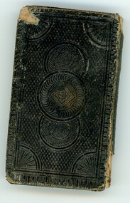
Book - HOSKING AND HUNKIN COLLECTION: BIBLE, 1800s
HOSKING AND HUNKIN COLLECTION: Small Bible inside envelope. On Binder: New Testament Inside front cover: This Book Belongs to Ellen Nancarrow November 8th 1857 Redruth Coomb Inside second page: This is a present given to Emily Hoskong by her Aunt Helen a a token of Love November 1860. Bible Details: The New Testament of our Lord and Saviour Jesus Christ translated out of the original Greek and with the former translations diligently compared and revised, by his Majestiy's special Command appointed to be read in Churches. Oxford prineted at the Univerity Press for the British and Froreign Bible Society, instituted in London in the year 1804; and sold to Subscribers at the Society house Earl Street, Blackfriers, London. Diamond's 48's 1856. Cum Privilegio Note inside BibleBible given to Emily Hosking (m. Emmanuel Hunkin) from her aunt Ellen (Nancarrow) Redruth Coomb. 8 Nov 1860 prior to sailing to Victoria. Nancarrow = Valley of the Stags. On front of envelope: Her New Testament a precious possesion. Bible given to Emily Hosking (b. 12-2-1854 d. 22-5-1905) by her mother's sister Ellen Nancarrow (b 17 Mar 1827 husband Wm Hosking m. 1853 Rev. John Cornwall Wm. D. 10 July 1914) in 1860 8th Nov before leaving for Australia. Liven and mined at Eaglehawk, Vic. Then Rushworth area (farming) Emblen Hosking nee Nanacarrow RedruthCoomb Cornwall b. 6/3/1831 d. 20/5/1895 Gobarup. Rear of envelope: Yellow and black stickers (Women with flowers and Man with Scythe, and St. Piran's) written on 'Cornish Patron Saint's day - 5th March. Address Label: Ms Betty Night, 29 Gilbertson Street Essendon Vic 3040 Separate page of Notes: A note in the front of Hymn Book Emily Hosking born 12/2/1854 married 1873 her book. A reward - The Bible Christian Sabbath School, Sailors Gully June 29th 1868. Hyms - Bible Christian 2nd edition 1890. Bible Christian Book Room 26 Paxxxx Road E.C. Mrs E. Hunkin Eaglehawk B.C. Church January 21st (18) 94 Husband Emmanuel Huskin born 21/1/1852 - collection of hymns Wesley hymns Emmanuel Hunkin. 2. A collection of hymns Emmanuel Hunkin, Eaglehawk Bendigo.book -
 Eltham District Historical Society Inc
Painting, Audrey Cahn, Old Bakery, York Street, Eltham, May 1974
Painted for the Shire of Eltham Historical Society by Audrey Cahn, a member of our Society for many years and Vice President till 1978. Audrey was the sister of the late Charis Palling, founding president of our Society. She had remained a member for many years although she had moved from her family home at Warrandyte to live with her daughter in New South Wales. Audrey had been blind for some years but maintained a local interest by having our Newsletter read to her. Audrey's associations with Warrandyte started because her father Professor Osbourne had bought 60 acres in 1904. " Gold mining was beginning to die out and Warrandyte was a decaying area. Land was cheap because of the lack of transport and the soil was poor for farming” Audrey said. Audrey first attended school in the city at the Church of England Girls Grammar School and was always a bit rebellious. “If I felt some restrictions were unfair or some judgement unjust, I resented it”. Audrey got into Agricultural Science at Melbourne University and in 1928 was the second women to get such a degree. Audrey married in 1926, and later divorced Leslie Cahn an architect. They had twin daughters whom she left with her parents in Warrandyte while she studied dietetics during the depression. She found employment as a microbiologist at the Kraft/Walker Milk and Cheese Factory in Drouin - she drove home at weekends to see her daughters who were then at boarding school. During the war Audrey was in charge of catering at the Heidelberg Military Hospital – again the appointment of a women caused some unrest. She was in the army for more than 4 years and achieved the rank of General which-made her the most highly-ranked-woman at the hospital. After the war she became a senior lecturer in Dietetics at Melbourne University, again being aware of the limitations her gender brought to promotion possibilities. During her time at the university, she undertook a series of studies in nutritional biochemistry. Of especial note is the analysis of common dietary foods so that the composition and calorific value, the data that was needed for inclusion in Food tables - that professional sports people and weight-watchers so avidly follow today! She was an early proponent of the need to reduce fat intake and to substitute saturated fats with polyunsaturated fatty acids. In the 1950's Audrey and fellow workers established norms for the growth of Australian children to be compared with British and American children. Over 17 years they concluded that Australian children were overweight and inactive - what is new! She bought a cottage in Warrandyte as her home. In 1968 she retired to further develop her other interests as a potter and painter. Audrey was a foundation member of the group of potters that set up Potters Cottage. Audrey died in 2008 aged 102. (Ref:Newsletter No. 185 March 2009)art, artwork, audrey cahn, eltham, old bakery, york street -
 Flagstaff Hill Maritime Museum and Village
Functional object - Nail, circa 1825
Nails such as this solid copper nail were forged by blacksmiths. A nail of this length could have been used for the ship's decking. It was recovered from the shipwreck of the barque Children. The Children wrecking: The barque Children was one of the first vessels to be lost in the Western District the vessel was wrecked to the east of Warrnambool on 14th January 1838. When it ran ashore in hurricane-force winds, 22 passengers and crew were fortunate to escape being battered to death on the rocks. The Children broke up within 20 minutes, sweeping sixteen of those on board to their deaths. After eleven days, the survivors, all of whom were injured, were rescued and taken to Portland. According to Lloyd's Shipping Register 1837-1839, the Children was built in 1825 at Liverpool and operated by owners Gordon & Co, of London. Registration number 123/1837, James Henty then bought her in 1837 as a three-masted barque of 254 tons, with a hull of “part pitch pine, felt sheathed” and “coppered in 1837” at Launceston registered number 6/1837. In 1838 the Children, under her master Captain H. Browne, completed a successful round trip from Launceston to London (carrying wool and whale oil loaded in Portland), returning in late November of that year carrying a general cargo including house bricks used for ballast. On the 11th of January 1839, the Children sailed from Launceston for Adelaide, with 24 passengers, 14 crew, and an awkward mixed cargo, including 1500 sheep, 8 bullocks, 7 horses, and farming implements, and six whaleboats with associated whaling gear. One account states that when the Children were “put out from port she was light and badly ballasted”. The vessel immediately encountered four days of hurricane-force storms, eventually clearing on the early morning of the 14th. However, it was too late to take accurate measurements of the sun or stars to establish their position relative to the coast. The Children collided with a limestone stack at the entrance of Childers Cove, and the seas smashed her into pieces within half an hour. All the cargo and 16 lives were lost including 8 children. The Henty brothers contributed £150 towards a fund for the 22 survivors at a memorial service held in Launceston later that year. It was a major financial setback for James Henty and his brothers, but one from which they recovered. In a submission to the Governor of New South Wales dated 24 March 1840, the Henty’s summarised their work over the previous six years of establishing the Portland settlement stating. “Six stations have been occupied, one at Portland Bay three at the open country about 60 miles inland called ‘Merino Downs’ They have erected two houses at Portland Bay and two others at Merino Downs”.This nail is significant as part of the vessels original fixtures. The Children was delivering cargo intended for the Portland Bay settlement of her owners the James Henty brothers The wreck is also significant as one of the first vessels to have been lost in the Western District of Warrnambool. As a result the shipwreck of the Children is registered with the Victorian Heritage Register S116. Ship's nail, copper, with a washer attached. The nail has a round head, solid round shank and a flat end. It is bent, twisted and has indentations in the centre section. The nail was recovered from the wreck of the CHILDREN.warrnambool, flagstaff-hill-maritime-museum, shipwreck-coast, shipwreck artefact, the children, nail, copper nail, ship's nail, children shipwreck -
 Melton City Libraries
Photograph, Charles Ernest and Jessie Barrie with family, Unknown
This document is has been compiled by Wendy Barrie daughter of Ernest (Bon) and Edna Barrie and granddaughter of Charles E and Jessie M Barrie. I was born in during WW 11 and the first child of my generation to live on the ‘ Darlingsford’ property at Melton. My grandfather was well known in the district and was mostly referred to as Ernie. He shared the same initials as his second son Edgar. His three eldest sons lived and farmed in Melton for their entire lives. His descendants are still associated with farming, engineering and earthmoving in Melton. Ernie Barrie operated a travelling Chaff Cutter in the St Arnaud area where his parents William and Mary Ann had taken up land at Coonooer West in 1873. Ernie commenced his working life with a team of bullocks and a chaff cutter. The earliest connection he had with Melton was in 1887. By the beginning of the 20th century Ernie and his father William and brothers, William, Samuel, James Edwin,[Ted] Robert, Arthur and Albert have been associated with farming and milling in the Melton district. In the early 1900’s Ernie and his brother Ted were in partnership in a Chaff cutting and Hay processing Mill on the corner of Station and Brooklyn road Melton South. The mill was managed by William for a time. By 1906 Charles Ernest and James Edwin were in partnership in the Station Road mill when a connecting rail line across Brooklyn Road for a siding was constructed to the Melton Railway Station. In 1911 the Mill’s letterhead shows C.E. BARRIE Hay Pressing and Chaff Cutting Mills. Melton Railway Station. Telephone No 1 Melton. This Mill as sold to H S K Ward in 1916 and stood until 1977 when it burnt down in a spectacular fire. Ernie built a house at Melton South beside the Chaff Mill at Station Road in 1906 and married Jessie May Lang in August at the Methodist Church. Jessie’s father was Thomas Lang. He came to Melton in 1896 and was the Head Teacher at Melton State School No 430 until he retired in 1917. They had 9 children with 8 surviving to adulthood. Jessie and Ernie had 6 sons and 3 daughters. All the children lived at Darlingsford. In April 1910 the family left Melton for a brief period and moved to a farm in Trundle in NSW. They returned to Melton and purchased Darlingsford in May 1911. For a time during WW1 they lived at Moonee Ponds near the Lang grandparents at Ascot Vale. Mary and Bon attended Bank St State School. The children developed diphtheria in 1916 and their youngest boy, Cecil died of complications. Mary and Bon were taken to Fairfield Hospital and both recovered. At the end of the war influenza broke out the family returned to Darlingsford and shared the home for a short while with the Pearcey family who had been working the farm. By 1922 the family had and grown and Edgar, Tom, Horace, Jessie, Joyce and Jim were living a Darlingsford. Ernie continued during the 1920’s working the farm and attend his many civic and community commitments. Two 8 clydesdale horse teams were used to work the land which meant early rising for the horses to be fed and harnessed to commence the days work. In 1916 Ernie also became involved in a Chaff Mill on the corner of Sunshine and Geelong Road West Footscray, which at the time was being run by John Ralph Schutt. It was known an Schutt Barrie. A flour mill was added at a later stage. Other Schutt and Barrie mills were situated at Parwan and Diggers Rest. Another mill was situated beside the railway line at Rockbank. The Footscray mill ceased operation in 1968 Ernie spent a lot of time and energy at the Parwan Mill and travelling around Parwan and Balliang farms, where he came to know many of the families in the district. Ernies commitment to the civic development to the Melton and district was extensive, he was involved with a number of large events during the 1920’s such as the Melton Exhibitions and the 1929 Back to Melton Celebrations. He was a member of the Australian Natives Association at the turn of the century. He was Chairman of the School Committee at Melton State School 430 and the Melton South State School in thw1920s. He donated the land for a Hall for Melton South in 1909, known as Exford Hall and later in 1919 renamed Victoria Hall. The Hall was demolished in 1992. He was a Councillor, JP, and Vice President and President of the Melton Mechanics Institute Hall Committee in 1915- 1916. He was a member of the Methodist Church and later the Scots Presbyterian Church. He was Superintendent of the Sunday School of the Methodist Church to 1910 and later Scots Presbyterian Church until 1931. This is reflected in the theme of children in the stained glass window which was dedicated in his memory by his wife Jessie as a gift to the Scots Church. Charles Ernest Barrie made many generous donations to many charities who supported young people and children. In 1918 Jessie and Ernie made the first donation to a very prominent Victorian charity whose work still continues. Yooralla. In July 1931 Ernie’s untimely death was a major blow to the family and the Melton community. To this day people still vividly recall the day they lined the streets for his funeral. The day of the funeral is recalled as the day Melton stood as two of their prominent citizens who tragically died on the same day. Their eldest daughter Mary had married Keith Robinson in 1930 and had just moved to Heatherdale Toolern Vale with their year old baby son. Bon the eldest son was 22, Edgar 18, Tom 16, Horace 15, Jessie and Joyce 10 and Jim 8 years old. A heavy burden of responsibility fell on the shoulders of the two eldest children, Mary particularly for her mother and Bon stepped in assuming head of the family for his mother, brothers and sisters living at the Darlingsford homestead. In the early 1930’s the three eldest sons took on many of the Civic and Church commitments which their father had held. This community involvement extended well into the 1980s. In 1941 Bon married Edna Myers and they moved into a house shifted from Harkness Lane to Harkness Lane on the eastern section of the Darlingford property. Edgar married Margaret Hodgkinson a Primary school teacher at Melton in 1949 and they lived in the Darlingsford house. Earlier Tom married May Ferris and lived on the eastern side of Ferris Lane in the Ferris home. Bon , Edgar and Tom often operated as a team effort, in particular at harvest time when a larger team of workers was needed. The three farms cultivated wheat, barley and oats and supplied the Mill with sheafed hay. They continued using horse teams until mechanisation in the 1940’s made the horses redundant. By the 1960s their five sons continued with farming. Many loads of hay were transported to the Mill in Footscray. Well into the 1960s hired harvest hands along with agricultural university students were involved in bringing in he harvest. Stacking was an art form in itself and Tom held the expertise for building and shaping the sides and roof. The stacks built in the district each had their own unique shape and could be recognized by their builders. The Barrie brothers developed a mechanical fork lift for picking up complete stooks and moving them to be loaded to the elevator to build the haystack. The prototype built by Bill Gillespie was attached to a Bedford truck. Later refinements in a collaborative effort with the Gillespie brothers a multi pronged fork was attached to the front of tractor which was hydraulically operated to raise each stook onto trucks to be transported to the site of the haystacks. This method of handling sheaves significantly reduced laborious pitchforking individual sheaves. This invention was soon taken up by farmers far and wide and was a common sight in the district at harvest time in the stacking season. I recall visiting farmers calling in at the house at Ferris Road farm to inspect this break through invention. The Clydesdale horse teams were used into the 1940s but by the 1950s the Barries’ farms were fully mechanised. When the demand for sheafed hay declined other crops were introduced these included barley, lucerne, wheat and peas. Sheep were added to the mix in the 1950s in an attempt to keep the farms more viable. In the 1970s part of the Barrie’s farms were facing a major disruption with the impending compulsorily acquisition of a strip of land for the construction the freeway bypass, which divided access between the Darlingsford homestead with those on Ferris Lane. Charles Ernest Barrie and Jessie May Lang's children: 1. Mary Ena BARRIE was born on 07 October 1907. She died on 29 April 1999. 2. Ernest Wesley BARRIE was born on 29 April 1909 in Ascot Vale, Victoria, Australia.He died on 25 December 1985 in Melton, Victoria, Australia. 3. Cecil William BARRIE was born on 23 February 1911.He died on 25 May 1916. 4. Charles Edgar BARRIE was born on 01 June 1913.He died on 06 October 1975. 5. Thomas Lindsay BARRIE was born on 25 November 1914.He died on 14 September 1990 in Melton, Victoria, Australia. 6. William Horace BARRIE was born on 11 October 1915.He died on 19 December 1950. 7. Jessie Maud BARRIE was born on 06 November 1920 in Bacchus Marsh, Victoria, Australia.She died on 26 February 1994. 8. Dorothy Joyce BARRIE was born on 06 November 1920 in Bacchus Marsh, Victoria, Australia.She died on 18 March 2003.. 9. James Edward BARRIE was born on 17 January 1922 in Bacchus Marsh, Victoria, Australia.He died on 23 August 2004Family Photo with Edgar, Tom, Mary, Ernest (Bon), Horace, Jim, Charles Ernest, Jessie and Joycelocal identities -
University of Melbourne, Burnley Campus Archives
Album - Black and white and colour slides, Teaching Horticulture, 1952-1969
Large collection of slides used for teaching Horticulture. Difficult to identify whether they were taken at Burnley. Labelled and numbered 1-2501. Some dated but spread over 1950's to 1960's. Also 57 slides similar to 1-50 labelled but not numbered. Some photographs have been catalogued elsewhere. Missing numbers have been mixed up with other photographs. 1-50 Mostly fungal diseases. 57 slides not numbered - fungal diseases. 1-29 Mostly mosses. 31-41 Mostly liverworts and hornworts. 43-60 Ferns. 61-73 selaginella. 75-84 Ferns 85-114 Gymnosperms 115-1236 Miscellaneous 117-141 Angiosperms 142-294 Biology 296-307 Orchidaceae 311-316 Acacias 796-841 Trees 866-889 Roses 955-984 Eucalyptus 1009-1046 Greenhouse. 1052-1086, 1097-1152 Propagating fruit trees. 1087-1090 Cacti. 1154-1187 Planting and pruning principles. 1196-1218 Orchard, Nursery. 1211 June 1956. 1215 8/3/57. 1228-1258 Orchard Management. 1263-1345 Crafting and reworking. 1346-1373 Bulk handling. 1390-1400 Leaf scorch. 1424-1472 Vegetables.1473-1512 Potatoes, Research farm Toolangi 2/54. 1514-1686 Garden Design. 1688-1695 Cow Paddock, and in flood. 1958, Students. 1795-1798 P.R.I. 1928-32.1831-1838 Beaumaris Feb 1958.1840-1846 P. Vejjajiva's Farewell 23.2.1958. Pruning Day 2/7/60. 19777-1990 Genetics. 1991-2018 Weeds. 2020-2-50 Erosion. 2023 10/65 and soil conservation. 2072-2136 Fertilizers. 2144-2149 Rhizobia 1950's. 2155-2157 Lime. 2160-2228 Plough, Cultivators, etc. 2246-2296 Tatura 12/59. 2301-2237 Beef and Dairy Cattle. 2338-2354 Sheep. 2355-2372 Crops. 2357-2363 1952. 2364 1958. 2373-2397 Fodder conservation 1952-1956. 2398-2411 Fences. 2398-2406 11/52. 2418-2248 Longerenong Field day 1964. 2451-2455 Boom Sprayer 1960. Glasshouse Wagga Agric College Oct 69. Apr 84 M3 16-18 Cultivator? 2458-2483 Hydraulics,Power Farming Dec 1966-Mar 1967. 2487-2488 Hydrasulics Vane Pump Construction. 2491-2500 Mechanics. 2501 Rack Shaker. Extra 13 Pond life. Some slides see B18.0001: 1676, 1684, some between 1711-1792, 1881, some between 1911-1953.Not scanned yet.teaching, horticulture, greenhouse, propagation, pruning, cacti, planting, orchard nursery, orchard management, grafting and reworking, potatoes, toolangi, garden design, lagoon paddock, beaumaris excursion, p.vejjajiva, lagoon paddock in flood, fungal diseases, genetics, weeds, erosion, fertilizers, rhyzobia, lime, cultivation, tatura, cattle, sheep, crops, fodder, fences, hydraulics, mechanics, longerenong, cow paddock, plough, cultivator, boom sprayer, wagga agricultural college, vane pump -
 Flagstaff Hill Maritime Museum and Village
Functional object - Urinal, circa 1825
It is probable that the urinal was situated in the forward part of the ship rather than the stern, being one of two placed on either side of the deck and housed immediately adjacent to the doors into for-castle, or crew sleeping quarters. The toilets on maritime vessels were (and still are) called the ‘heads’, after the sanitation arrangements common until the end of the eighteenth century. The name was given to the ‘head’ of the ship, forward of the forecastle and around the beak or bowsprit. These first lavatories were floored with grating or nets so the force of the sea could wash them clean, and they were always used on the lee or non-weather side so the effluent fell directly into the water rather than back on board. The Children wrecking: The barque Children was one of the first vessels to be lost in the Western District the vessel was wrecked to the east of Warrnambool on 14th January 1838. When it ran ashore in hurricane-force winds, 22 passengers and crew were fortunate to escape being battered to death on the rocks. The Children broke up within 20 minutes, sweeping sixteen of those on board to their deaths. After eleven days, the survivors, all of whom were injured, were rescued and taken to Portland. According to Lloyd's Shipping Register 1837-1839, the Children was built in 1825 at Liverpool and operated by owners Gordon & Co, of London. Registration number 123/1837, James Henty then bought her in 1837 as a three-masted barque of 254 tons, with a hull of “part pitch pine, felt sheathed” and “coppered in 1837” at Launceston registered number 6/1837. In 1838 the Children, under her master Captain H. Browne, completed a successful round trip from Launceston to London (carrying wool and whale oil loaded in Portland), returning in late November of that year carrying a general cargo including house bricks used for ballast. On the 11th of January 1839, the Children sailed from Launceston for Adelaide, with 24 passengers, 14 crew, and an awkward mixed cargo, including 1500 sheep, 8 bullocks, 7 horses, and farming implements, and six whaleboats with associated whaling gear. One account states that when the Children were “put out from port she was light and badly ballasted”. The vessel immediately encountered four days of hurricane-force storms, eventually clearing on the early morning of the 14th. However, it was too late to take accurate measurements of the sun or stars to establish their position relative to the coast. The Children collided with a limestone stack at the entrance of Childers Cove, and the seas smashed her into pieces within half an hour. All the cargo and 16 lives were lost including 8 children. The Henty brothers contributed £150 towards a fund for the 22 survivors at a memorial service held in Launceston later that year. It was a major financial setback for James Henty and his brothers, but one from which they recovered. In a submission to the Governor of New South Wales dated 24 March 1840, the Henty’s summarised their work over the previous six years of establishing the Portland settlement stating. “Six stations have been occupied, one at Portland Bay three at the open country about 60 miles inland called ‘Merino Downs’ They have erected two houses at Portland Bay and two others at Merino Downs”.This urinal is significant as part of the vessels original fittings he Children was delivering cargo intended for the Portland Bay settlement of her owners the James Henty brothers The wreck is also significant as one of the first vessels to have been lost in the Western District of Warrnambool. As a result the shipwreck of the Children is registered with the Victorian Heritage Register S116. A lead urinal with a rounded back at the top splash plate with an attached semi-circular receptacle or basin (20cm deep and projecting forward 30cm). At the sides are flanges with bolt holes connecting to a ship's wall. The urinal is drained by a funnel-shaped outlet also made of lead, reducing from a 10cm radius to a joined 5 cm pipe. The urinal was recovered from the wreck of the CHILDREN.Noneflagstaff hill, warrnambool, flagstaff-hill, flagstaff-hill-maritime-museum, shipwreck-coast, shipwreck artefact, the children, lead ship’s plumbing, crew urinal, the ‘heads’, ship plumbing, james henty, portland bay, urinal, ship's urinal -
 Ballarat Heritage Services
Photograph - Colour, Knowth and New Grange, Ireland, World Heritage Centre
The Megalithic Passage Tombs of Newgrange, Knowth, Dowth, Fourknocks, Loughcrew and Tara are located in the present day County Meath in Ireland's Ancient East. The Boyne Valley Mounds at Newgrange, Knowth and Dowth were built around 3200BC making them older than Stonehenge in England and the Pyramids of Giza in Egypt. Built by Neolithic farming communities about 5000 years ago, the passage tombs have clear astronomical alignments such as the Winter Solstice Sunrise at Newgrange and the Equinox Sunrise at Loughcrew. Judging from the splendour and magnificence of Newgrange and Knowth it is likely that these temples of the ancestors were places of astrological, spiritual, religious and ceremonial importance, much as present day cathedrals are places of worship where dignitaries may be laid to rest. There is a lively debate about whether these wonderful megalithic structures were built primarily as burial tombs, sacred temples or astronomical observatories. While passage tomb is the traditional description for Newgrange and similar structures, chambered cairn or passage mound are the descriptions favoured by those who consider the passage tomb description too narrow. The large stones surrounding and inside the Passage Tombs are decorated with Megalithic Art such as spirals, concentric circles, triangles, zigzags and images which have been interpreted as the sun, moon and the human face. Irish passage tombs tend to occur in clusters traditionally described as a Necropolis or cemetery. The Boyne cluster includes Newgrange, Knowth, Dowth and Townleyhall. The other great clusters in County Meath are on the hills around Loughcrew. The ancient Boyne Valley passage tomb mounds at Newgrange, Knowth and Dowth have been designated World Heritage Site status by UNESCO and attract 200,000 visitors per year. The sites and Visitor Centre are managed by the OPW (Office of Public Works). Newgrange is best known for the illumination of its passage and chamber by the winter solstice sun. The site is open to the public with controlled access to the passage and chamber. Tours of Newgrange start at the Brú na Bóinne Visitor Centre located near the village of Donore, Co. Meath. Knowth has two passages and is surrounded by seventeen satellite cairns. The site is open to the public; however there is no public access to the interior passages and chambers. Tours of Knowth also start at the Brú na Bóinne Visitor Centre. Dowth is the only one of the three large Brú na Bóinne Passage Tombs which is not accessible from the Visitor Centre situated on the south bank of the river. Visitors to Dowth must drive directly to the site on the north bank, a couple of miles from the Slane / Drogheda road. Fourknocks with its short passage leading into a wide pear shaped chamber is in similar style to Tombs in Portugal. Just inside the main chamber to the left of the entrance is one of the few representations of a human face from the Neolithic Period in ancient Ireland. Entrance to Fourknocks Megalithic Passage Tomb. Megalithic Art - Loughcrew, Co. Meath Loughcrew Cairns form the largest complex of Megalithic structures in Ireland. The Cairns contain symbolic engravings similar in style to Newgrange. Like other Passage Tombs in ancient Ireland, they have clear astrological alignments.Tara was the seat of the High Kings of Ireland in the first millennium A.D. however Tara is also the site of a Passage Tomb known as the Mound of the Hostages that was built about 2,500 B.C. knowth, newgrange, megalith, ireland, world heritage, neolithic -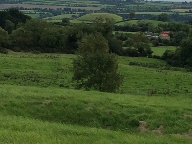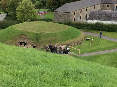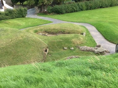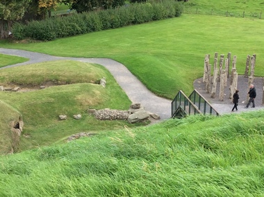
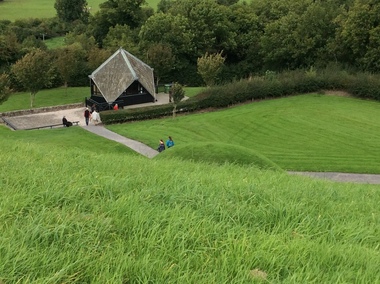 Ballarat Heritage Services
Photograph - Photograph - Colour, Knowth and New Grange, Ireland, World Heritage Centre, 2017
The Megalithic Passage Tombs of Newgrange, Knowth, Dowth, Fourknocks, Loughcrew and Tara are located in the present day County Meath in Ireland's Ancient East. The Boyne Valley Mounds at Newgrange, Knowth and Dowth were built around 3200BC making them older than Stonehenge in England and the Pyramids of Giza in Egypt. Built by Neolithic farming communities about 5000 years ago, the passage tombs have clear astronomical alignments such as the Winter Solstice Sunrise at Newgrange and the Equinox Sunrise at Loughcrew. Judging from the splendour and magnificence of Newgrange and Knowth it is likely that these temples of the ancestors were places of astrological, spiritual, religious and ceremonial importance, much as present day cathedrals are places of worship where dignitaries may be laid to rest. There is a lively debate about whether these wonderful megalithic structures were built primarily as burial tombs, sacred temples or astronomical observatories. While passage tomb is the traditional description for Newgrange and similar structures, chambered cairn or passage mound are the descriptions favoured by those who consider the passage tomb description too narrow. The large stones surrounding and inside the Passage Tombs are decorated with Megalithic Art such as spirals, concentric circles, triangles, zigzags and images which have been interpreted as the sun, moon and the human face. Irish passage tombs tend to occur in clusters traditionally described as a Necropolis or cemetery. The Boyne cluster includes Newgrange, Knowth, Dowth and Townleyhall. The other great clusters in County Meath are on the hills around Loughcrew. The ancient Boyne Valley passage tomb mounds at Newgrange, Knowth and Dowth have been designated World Heritage Site status by UNESCO and attract 200,000 visitors per year. The sites and Visitor Centre are managed by the OPW (Office of Public Works). Newgrange is best known for the illumination of its passage and chamber by the winter solstice sun. The site is open to the public with controlled access to the passage and chamber. Tours of Newgrange start at the Brú na Bóinne Visitor Centre located near the village of Donore, Co. Meath. Knowth has two passages and is surrounded by seventeen satellite cairns. The site is open to the public; however there is no public access to the interior passages and chambers. Tours of Knowth also start at the Brú na Bóinne Visitor Centre. Dowth is the only one of the three large Brú na Bóinne Passage Tombs which is not accessible from the Visitor Centre situated on the south bank of the river. Visitors to Dowth must drive directly to the site on the north bank, a couple of miles from the Slane / Drogheda road. Fourknocks with its short passage leading into a wide pear shaped chamber is in similar style to Tombs in Portugal. Just inside the main chamber to the left of the entrance is one of the few representations of a human face from the Neolithic Period in ancient Ireland. Entrance to Fourknocks Megalithic Passage Tomb. Megalithic Art - Loughcrew, Co. Meath Loughcrew Cairns form the largest complex of Megalithic structures in Ireland. The Cairns contain symbolic engravings similar in style to Newgrange. Like other Passage Tombs in ancient Ireland, they have clear astrological alignments.Tara was the seat of the High Kings of Ireland in the first millennium A.D. however Tara is also the site of a Passage Tomb known as the Mound of the Hostages that was built about 2,500 B.C. Colour photograph of Knowth and New Grange, Ireland, World Heritage Centreknowth, newgrange, megalith, ireland, world heritage, neolithic -
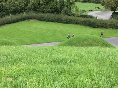 Ballarat Heritage Services
Photograph - Colour, Knowth and New Grange, Ireland, World Heritage Centre
The Megalithic Passage Tombs of Newgrange, Knowth, Dowth, Fourknocks, Loughcrew and Tara are located in the present day County Meath in Ireland's Ancient East. The Boyne Valley Mounds at Newgrange, Knowth and Dowth were built around 3200BC making them older than Stonehenge in England and the Pyramids of Giza in Egypt. Built by Neolithic farming communities about 5000 years ago, the passage tombs have clear astronomical alignments such as the Winter Solstice Sunrise at Newgrange and the Equinox Sunrise at Loughcrew. Judging from the splendour and magnificence of Newgrange and Knowth it is likely that these temples of the ancestors were places of astrological, spiritual, religious and ceremonial importance, much as present day cathedrals are places of worship where dignitaries may be laid to rest. There is a lively debate about whether these wonderful megalithic structures were built primarily as burial tombs, sacred temples or astronomical observatories. While passage tomb is the traditional description for Newgrange and similar structures, chambered cairn or passage mound are the descriptions favoured by those who consider the passage tomb description too narrow. The large stones surrounding and inside the Passage Tombs are decorated with Megalithic Art such as spirals, concentric circles, triangles, zigzags and images which have been interpreted as the sun, moon and the human face. Irish passage tombs tend to occur in clusters traditionally described as a Necropolis or cemetery. The Boyne cluster includes Newgrange, Knowth, Dowth and Townleyhall. The other great clusters in County Meath are on the hills around Loughcrew. The ancient Boyne Valley passage tomb mounds at Newgrange, Knowth and Dowth have been designated World Heritage Site status by UNESCO and attract 200,000 visitors per year. The sites and Visitor Centre are managed by the OPW (Office of Public Works). Newgrange is best known for the illumination of its passage and chamber by the winter solstice sun. The site is open to the public with controlled access to the passage and chamber. Tours of Newgrange start at the Brú na Bóinne Visitor Centre located near the village of Donore, Co. Meath. Knowth has two passages and is surrounded by seventeen satellite cairns. The site is open to the public; however there is no public access to the interior passages and chambers. Tours of Knowth also start at the Brú na Bóinne Visitor Centre. Dowth is the only one of the three large Brú na Bóinne Passage Tombs which is not accessible from the Visitor Centre situated on the south bank of the river. Visitors to Dowth must drive directly to the site on the north bank, a couple of miles from the Slane / Drogheda road. Fourknocks with its short passage leading into a wide pear shaped chamber is in similar style to Tombs in Portugal. Just inside the main chamber to the left of the entrance is one of the few representations of a human face from the Neolithic Period in ancient Ireland. Entrance to Fourknocks Megalithic Passage Tomb. Megalithic Art - Loughcrew, Co. Meath Loughcrew Cairns form the largest complex of Megalithic structures in Ireland. The Cairns contain symbolic engravings similar in style to Newgrange. Like other Passage Tombs in ancient Ireland, they have clear astrological alignments.Tara was the seat of the High Kings of Ireland in the first millennium A.D. however Tara is also the site of a Passage Tomb known as the Mound of the Hostages that was built about 2,500 B.C. knowth, newgrange, megalith, ireland, world heritage, neolithic -
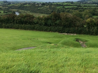 Ballarat Heritage Services
Photograph - Colour, Knowth and New Grange, Ireland, World Heritage Centre
The Megalithic Passage Tombs of Newgrange, Knowth, Dowth, Fourknocks, Loughcrew and Tara are located in the present day County Meath in Ireland's Ancient East. The Boyne Valley Mounds at Newgrange, Knowth and Dowth were built around 3200BC making them older than Stonehenge in England and the Pyramids of Giza in Egypt. Built by Neolithic farming communities about 5000 years ago, the passage tombs have clear astronomical alignments such as the Winter Solstice Sunrise at Newgrange and the Equinox Sunrise at Loughcrew. Judging from the splendour and magnificence of Newgrange and Knowth it is likely that these temples of the ancestors were places of astrological, spiritual, religious and ceremonial importance, much as present day cathedrals are places of worship where dignitaries may be laid to rest. There is a lively debate about whether these wonderful megalithic structures were built primarily as burial tombs, sacred temples or astronomical observatories. While passage tomb is the traditional description for Newgrange and similar structures, chambered cairn or passage mound are the descriptions favoured by those who consider the passage tomb description too narrow. The large stones surrounding and inside the Passage Tombs are decorated with Megalithic Art such as spirals, concentric circles, triangles, zigzags and images which have been interpreted as the sun, moon and the human face. Irish passage tombs tend to occur in clusters traditionally described as a Necropolis or cemetery. The Boyne cluster includes Newgrange, Knowth, Dowth and Townleyhall. The other great clusters in County Meath are on the hills around Loughcrew. The ancient Boyne Valley passage tomb mounds at Newgrange, Knowth and Dowth have been designated World Heritage Site status by UNESCO and attract 200,000 visitors per year. The sites and Visitor Centre are managed by the OPW (Office of Public Works). Newgrange is best known for the illumination of its passage and chamber by the winter solstice sun. The site is open to the public with controlled access to the passage and chamber. Tours of Newgrange start at the Brú na Bóinne Visitor Centre located near the village of Donore, Co. Meath. Knowth has two passages and is surrounded by seventeen satellite cairns. The site is open to the public; however there is no public access to the interior passages and chambers. Tours of Knowth also start at the Brú na Bóinne Visitor Centre. Dowth is the only one of the three large Brú na Bóinne Passage Tombs which is not accessible from the Visitor Centre situated on the south bank of the river. Visitors to Dowth must drive directly to the site on the north bank, a couple of miles from the Slane / Drogheda road. Fourknocks with its short passage leading into a wide pear shaped chamber is in similar style to Tombs in Portugal. Just inside the main chamber to the left of the entrance is one of the few representations of a human face from the Neolithic Period in ancient Ireland. Entrance to Fourknocks Megalithic Passage Tomb. Megalithic Art - Loughcrew, Co. Meath Loughcrew Cairns form the largest complex of Megalithic structures in Ireland. The Cairns contain symbolic engravings similar in style to Newgrange. Like other Passage Tombs in ancient Ireland, they have clear astrological alignments.Tara was the seat of the High Kings of Ireland in the first millennium A.D. however Tara is also the site of a Passage Tomb known as the Mound of the Hostages that was built about 2,500 B.C. knowth, newgrange, megalith, ireland, world heritage, neolithic