Showing 650 items matching "footpaths"
-
 Port Melbourne Historical & Preservation Society
Plan - Boundary Street from Quinn Street to Evans Street, Engineering Department, Town of Port Melbourne, 1893 - 1919
Plan of Boundary Street from Quinn Street to Evans Street 1893.engineering - roads streets lanes and footpaths -
Port Melbourne Historical & Preservation Society
Plan - Clark Street between Poolman Street and Graham Street, Port Melbourne, Engineering Department, Town of Port Melbourne, 1893 - 1919
Plan of Clark Street between Poolman and Graham Streets 1893.engineering - roads streets lanes and footpaths -
Port Melbourne Historical & Preservation Society
Plan - Evans Street from Ingles Street to Boundary Street, Engineering Department, Town of Port Melbourne, 1893 - 1919
Plan of Evans Street from Ingles Street to Boundary Street Loan no 5 1893.engineering - roads streets lanes and footpaths -
Port Melbourne Historical & Preservation Society
Plan - Williamstown Road from Farrell Street to Derham Street, 1893 - 1919
Plan of Williamstown Road from Farrell Street to Derham Street 1893.engineering - roads streets lanes and footpaths -
Port Melbourne Historical & Preservation Society
Plan - Metalling, watertables, channelling and asphalte paths, Engineering Department, Town of Port Melbourne, 1893 - 1919
Type sections for metalling, watertables, channelling and asphalte (tarpaved) paths. Loan No.5 1893.engineering department - city of port melbourne, engineering - roads, streets, lanes, and footpaths. -
Port Melbourne Historical & Preservation Society
Plan - Williamstown Road from Farrell Street to Derham Street, Engineering Department, Town of Port Melbourne, 1893 - 1919
Plan of Williamstown Road, from Farrell Street to Derham Street. Loan No.5.engineering - roads streets lanes and footpaths -
Port Melbourne Historical & Preservation Society
Plan - Proposed crossing, Rouse Street at Nott Street, George Kelly, Borough Surveyor, 27 Oct 1864
Place of Proposed Crossing in Rouse Street (Corner Nott Street) PlanGeo. Kelly, Cr.(?), Borough Surveyor, Sandridge, 27-10-1864engineering - roads streets lanes and footpaths, george kelly -
Port Melbourne Historical & Preservation Society
Plan - Pickles Street from Sandridge Road to Spring Street/Tribe Street, Borough of Sandridge, 23 Jul 1880
Plan of Pickles Street, from Sandridge (City) Road to Spring Street/Tribe Street.engineering - roads streets lanes and footpaths -
Port Melbourne Historical & Preservation Society
Plan - Johnson Street from Graham Street to Danks Street, Borough of Port Melbourne, 25 Jul 1890
Plan of Johnson Street, from Graham Street to Danks Street. (including Drainage Sections)Michael Minahan (?) Contractor, 25-7-1890engineering - roads streets lanes and footpaths, michael minahan -
Port Melbourne Historical & Preservation Society
Plan - Danks Street from Pickles Street to Esplanade East, Town of Port Melbourne, 28 Feb 1893
Plan of Danks Street, from Pickles Street to Esplanade East and bearing the seal of the Borough of Port Melbourne as well as agreement to contract to carry out works.A.V. Heath (Town Surveyor):Michael Minahan (?) (Contractor):J.J. Bartlett (Mayor):Prohasky (Councillor):E.C. Crockford (Town Clerk):W. Harrison (Witness)engineering - roads streets lanes and footpaths, engineering - fences, local government - borough of port melbourne, arthur victor heath, james john bartlett, william henry prohasky, edward c crockford, town clerks, w harrison, michael minahan -
Port Melbourne Historical & Preservation Society
Plan - Path, Bay Street and Crockford Street, Municipality of Sandridge, 8 Oct 1861
Path works, west side of Bay Street and Crockford Street (both sides) bearing Seal of Municipality of Sandridge.Frederick William Ball, Muncipal Surveyor: Kellyengineering - roads streets lanes and footpaths, local government - borough of sandridge, frederick william bull, kelly (surveyor) -
Port Melbourne Historical & Preservation Society
Plan - Heath Street, Port Melbourne, Borough of Sandridge, Mar 1864
Plan of longitudinal and cross sections of proposed works in Heath Street.M. Tierney:Denis Sullivan:Thos. P. Warren:Geo. Kelly (Borough Surveyor)engineering - roads streets lanes and footpaths, m tierney, denis sullivan, thomas p warren, george kelly -
Port Melbourne Historical & Preservation Society
Plan - Lyons Street, Port Melbourne, Borough of Sandridge, 9 Oct 1877
Plan of Lyons Street, showing longitudinal section, ground plan and transverse section.Minehan, Michael:Clark, Edward C (Town Clerk)engineering - roads streets lanes and footpaths, michael minahan, edward clark, town clerks -
Port Melbourne Historical & Preservation Society
Plan - Pathworks, Heath Street, Port Melbourne, Borough of Sandridge, 16 Feb 1861
Plan - Pathworks Heath StreetFrederick Wm. Bull Municipal Surveyor Sandridgeengineering - roads streets lanes and footpaths, frederick william bull -
 Port Melbourne Historical & Preservation Society
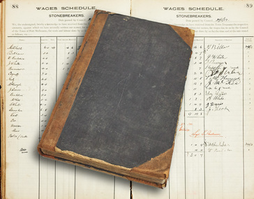
Book - Stonebreakers wages, Port Melbourne Council, 1911 - 1919
Wages schedule for StoneBreakers, for work and labour done for the Town of Port Melbourne Council from 31 Oct 1911 to 11 Feb 1919. Many signatures by the workerslocal government - town of port melbourne, workers, engineering - roads streets lanes and footpaths -
 Port Melbourne Historical & Preservation Society
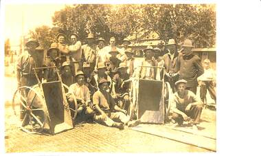
Photograph - "Susso" workers, Port Melbourne, 1930s
Percy MAY is the father of John MAY (ex Pres of PMHPS)Sepia copy photograph of "susso" workers in the 1930s in Port Melbourne. Hatless man in back row is Percy MAY. There are two large wheelbarrows at front of photo - road building. Also a policeman on right.workers, engineering - roads streets lanes and footpaths, police, percy allan may -
 Port Melbourne Historical & Preservation Society
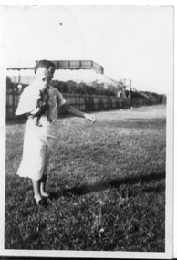
Photograph - Fred Nicholson and his mother, bridge over railway at Boundary Street, Port Melbourne, 1938
Photo showing bridge over railway at Boundary St. Fred Nicholson and his mother, 1938.families, engineering - roads streets lanes and footpaths, fred nicholson, boundary street -
Port Melbourne Historical & Preservation Society
Plan - Concept, Boulevard upgrade at Sandridge Beach, existing conditions, 2003
Plans. Existing conditions. Concept for the Boulevard upgrade at Sandridge Beach. Dated October 2003local government - city of port melbourne, engineering - roads streets lanes and footpaths -
Port Melbourne Historical & Preservation Society
Plan - Concept, Boulevard upgrade at Sandridge Beach, traffic treatment, 2003
Plans. Traffic treatment. Concept for the Boulevard upgrade at Sandridge Beach. Dated October 2003local government - city of port melbourne, engineering - roads streets lanes and footpaths -
Port Melbourne Historical & Preservation Society
Plan - Concept, Boulevard upgrade at Sandridge Beach, landscape, 2003
Plans. Landscape concept for the Boulevard upgrade at Sandridge Beach. Dated October 2003local government - city of port phillip, engineering - roads streets lanes and footpaths -
Port Melbourne Historical & Preservation Society
Document - Memo, Department of Public Works re Williamstwon Short Road, 12 Sep 1887
Items 598.01-.04 originally pinned togetherFoolscap, printed single page copy of Dept of Public Works memo re Williamstown Short Road, dated 12 Sept 1887; original memo dated 19.8.1887. Includes costs of grading road.engineering - roads streets lanes and footpaths, edward clark, town clerks, william thwaites -
Port Melbourne Historical & Preservation Society
Letter - Department of Public Works to Town Clerk re Williamstown Road, 15 Mar 1888
Letter from Department of Public Works 15 March 1888 to Town Clerk Port Melbourne re Williamstown RoadNotes by E.C. Clark in marginengineering - roads streets lanes and footpaths, edward clark, town clerks -
Port Melbourne Historical & Preservation Society
Letter - Town Clerk, Williamstown to Town Clerk, Port Melbourne re Williamstown Road grant deputation, 22 Mar 1888
Items 598.01-.04 originally pinned togetherLetter from Town Clerk Williamstown 22 March 1888 to Town Clerk Port Melbourne to confirm attendance at deputation re Williamstown Road grantengineering - roads streets lanes and footpaths, edward clark, town clerks -
Port Melbourne Historical & Preservation Society
Document - Notice, Attendance at deputation to Public Work re Williamstown Road grant, Edward Clark, Town Clerk, 26 Mar 1888
Items 598.01-.04 originally pinned togetherSmall (4 pg) notice printed front only, inviting attendance at deputation to Public Works re Williamstown Road grant on 27.3.1888'(Copy)' in ink at topengineering - roads streets lanes and footpaths, edward clark, town clerks -
Port Melbourne Historical & Preservation Society
Archive - File, Safer Routes to Shops in Port Melbourne, 2000 - 2001
This project involved community representatives in the identification of unsafe points on the route between Wintringham Hostel and Bay Street, in particular for elderly and disabled people. The intention of the project was to improve coordination between departments of Council viz. Health & Safety with Infrastructure. The lack of coordination that was a legacy of contracting-out was evident throughout the project.File of documents, reports, correspondence, photos relating to the project "Safer Routes to Shops in Port Melbourne" (between Wintringham Hostel and Bay Street) 2000-2001engineering - roads streets lanes and footpaths, matt rodda, jim hillis, perce mcguire white, perce white -
Port Melbourne Historical & Preservation Society
Document - Blueprint, portable stonebreaker, Austral Oitis Engineering Company, 1913
Blueprint of portable stonebreaker designed 1913 by Australia Otis Engineering of South Melbourneengineering - roads streets lanes and footpaths, business and traders, austral otis engineering co pty ltd, stonebreaker -
Port Melbourne Historical & Preservation Society
Plan - Proposed Lorimer Street realignment, City of Port Melbourne, 28 Oct 1938
Printed map of City of Port Melbourne with proposed Lorimer Street realignment marked in red and blue.Pencilled lower right: Proposed realignment Lorimer St Also 'Request by Council under Sec 523 L. Getch' : (Getel?)engineering - roads streets lanes and footpaths, l getel, l getch -
Port Melbourne Historical & Preservation Society
Plan - Ingles Street, Port Melbourne, 12 Jan 1866
Plans for Ingles Street showing both ground plan and longitudinal and traverse sections at Station Place, Heath, Nott and Bay Streets.Signed by surveyor Chas. Clay and James Bibby plus Thomas (Reek) Warren as witness to latter sig. Also a no: 355/H1 added later.engineering - roads streets lanes and footpaths, charles clay, thomas (reek) warren, james bibby -
Port Melbourne Historical & Preservation Society
Legal record - Contract, construction of Williamstown Short Road, Port Melbourne, 13 Nov 1896
Contract for the construction of Williamstown Short Road and part of Graham Streetengineering - roads streets lanes and footpaths, rumpt bros & ebeling, town of port melbourne, town of williamstown -
Port Melbourne Historical & Preservation Society
Letter - Department of Lands and Survey re proclaimation of Beach Street, Sandridge, Department of Lands and Survey, 16 Mar 1861
Handwritten letter on blue foolscap laid paper, from Dept of Lands and Survey 16.3.1861, directing attention to proclamation in Government Gazette re Beech Street (sic) Sandridgelocal government - borough of sandridge, engineering - roads streets lanes and footpaths