Showing 1051 items
matching government house melbourne
-
 Bendigo Historical Society Inc.
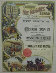
Document - COUNTRY FIRE BRIGADES CERTIFICATE, 1895
Certificate awarded to Temperance Fire Brigade Bendigo from the Country Fire Brigade's Board Victoria for second prize in Discipline Certificate - Brigades Classed D and Upwards. Printed on stiff paper with illustrations of horse drawn fire vehicles and firemen. Markings - Sands & McDougall Limited, Melbourne.organization, government, bendigo fire brigade -
 Bendigo Historical Society Inc.
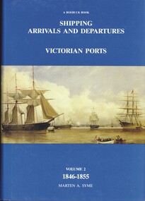
Book - SHIPPING ARRIVALS AND DEPARTURES VICTORIAN PORTS VOLUME 2 1846-1855, 1987
Compiled from newspaper reports, customs and other Government records and records of other Colonial ports, the list documents the arrival of vessels containing assisted and unassisted immigrants before and during the gold rush, the intra-colonial trading voyages, the growth in overseas trade from Melbourne and Geelong in wool, tallow skins and gold dust and the surge of activity flowing from the discovery of gold in Victoria in 1852.Marten A Symevictoria, history, shipping, shipping, transport, port phillip history, family history. -
 Bendigo Historical Society Inc.
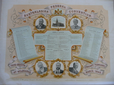
Document - AUSTRALASIAN FEDERAL CONVENTION CERTIFICATE, 1898
Paper certificate commemorating the Australian Federal Convention with photograph of State Premiers and names of participants, presented to Mrs. George Lansell of Bendigo by F. C. Mason, Speaker, Melbourne. Markings - 'Presented to Mrs. George Lansell, Bendigo, by F C Mason (Frederick Conway Mason), Speaker, Melbourne, Victoria.' 'Robert S. Brain, Government Printer, Melbourne.' 'L. (Ludwig) Lang del and lith.'person, individual, george lansell -
 Bendigo Historical Society Inc.
Map - JACK FLYNN COLLECTION: TARNAGULLA, 13/05/1922
Map: Parish of Tarnagulla . This Item is in very poor condition.By Authority, A. J. Mullen, Government Printer, Melbourne. Lithographed at the Department of Lands and Survey, Melbourne by W. J. Butsonmap, gladstone, parish plan, tarnagulla -
 Bendigo Historical Society Inc.
Map - JACK FLYNN COLLECTION: SALISBURY, 1965
Map: Parish of Salisbury, County of Bendigo. Parish plan.By Authority A. C. Brooks Government Printer, Melbourne. Drawn and Reproduced at the Department of Lands and Survey, Melbourne.map, bendigo, parish plan, salisbury -
 Bendigo Historical Society Inc.
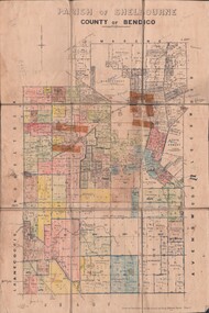
Map - JACK FLYNN COLLECTION: SHELBOURNE, 11/02/1937
Map: Parish of Shelbourne, County of Bendigo. Parish plan.By Authority, H. J.Green, Government Printer. Drawn and Reproduced at the Dept, of Lands and Survey, Melbourne, Victoria.map, bendigo, parish plan, shelbourne -
 Bendigo Historical Society Inc.
Map - JACK FLYNN COLLECTION: TOWNSHIP OF STANHOPE, December 1950
Map: Township of Stanhope, Parish of Girgarre, County of Rodney. Parish plan.By Authority J. J. Gourley, Government Printer, Melbourne. Drawn and Reproduced at the Dept, of Lands and Survey, Melbourne, Victoria.map, rodney, township, stanhope -
 Bendigo Historical Society Inc.
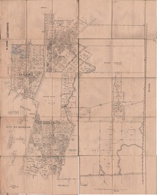
Map - JACK FLYNN COLLECTION: SANDHURST SHEET 6, January 1947
Map: Parish of Sandhurst Sheet 6. County of Bendigo. Parish plan.By Authority J. J. Gourley, Government Printer, Melbourne. Drawn and Reproduced at the Dept, of Lands and Survey, Melbourne, Victoria.map, bendigo, parish plan, sandhurst sheet 6 -
 Bendigo Historical Society Inc.
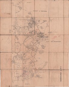
Map - JACK FLYNN COLLECTION: SANDHURST SHEET 2, January 1947
Map: Parish of Sandhurst Sheet 2, County of Bendigo. Parish plan.By Authority J. J. Gourley, Government Printer, Melbourne. Drawn and Reproduced at the Dept, of Lands and Survey, Melbourne, Victoria.map, bendigo, parish plan, sandhurst sheet 2 -
 Bendigo Historical Society Inc.
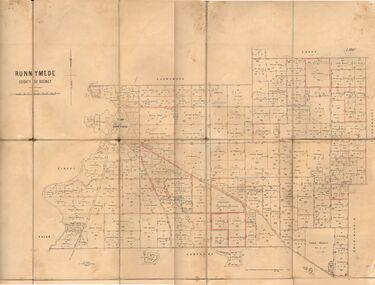
Map - JACK FLYNN COLLECTION: RUNNYMEDE, June 1946
Map: Parish of Runnymede, County of Rodney. Parish plan.By Authority: J.J. Goourley, Government Printer, Melbourne. Drawn and Reproduced at the Lands and Servey, Melbourne, Victoria. June, 1946.map, rodney, parish plan, runnymede -
 Bendigo Historical Society Inc.
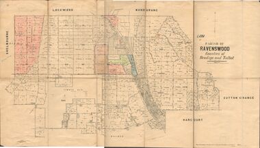
Map - JACK FLYNN COLLECTION: RAVENSWOOD, 12/12/1922
Map: Parish of Ravenswood, Counties of Bendigo and Talbot. Parish plan.By Authority A.J. Mullet Government Printer Melbourne. Photo Lithographed at the Department of lands and Survey, Melbourne by W.J. Butsonmap, bendigo, parish plan, ravenswood -
 Bendigo Historical Society Inc.
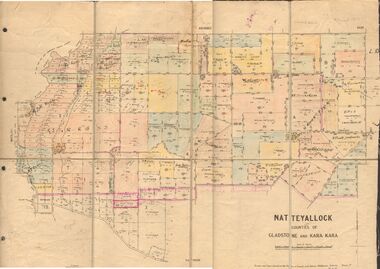
Map - JACK FLYNN COLLECTION: NATTE YALLOCK, 22/06/1937
Map: Parish of Natte Yallock, Counties of Gladstone and Kara Kara. Parish plan.By Authority H.J. Green Government Printer Melbourne. Drawn and Reproduced at the Depart., of Lands and Survey, Melbourne, Victoria.map, gladstone, parish plan, natte yallock -
 Bendigo Historical Society Inc.
Map - JACK FLYNN COLLECTION: MUSKERRY, 1962
Map: Parish of Muskerry, County of Rodney. Parish plan.By Authority: A.C. Brooks, Government Printer, Melbourne. Drawn and reproduced at the Department of Lands and Survey, Melbournemap, rodney, parish plan, muskerry -
 Bendigo Historical Society Inc.
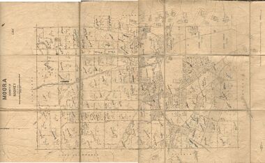
Map - JACK FLYNN COLLECTION: MOORA, 9/10/22
Map: Parish of Moora, County of Rodney. Parish plan.By Authority A.J. Mullet Government Printer Melbourne. Photo Lithographed at the Dept, of Lands and Survey, Melbourne by W.J. Butson. 3.10.22map, rodney, parish plan, moora -
 Bendigo Historical Society Inc.
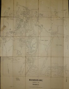
Map - JACK FLYNN COLLECTION: MANDURANG SHEET 2, March 1947
Map: Parish of Mandurang, Sheet 2, County of Bendigo. Parish plan.By Authority J.J.Gourley Government Printer Melbourne. Drawn and Produced at the Dept, of Lands and SurveyMelbourne, Victoria. March 1947.map, bendigo, parish plan, mandurang -
 Bendigo Historical Society Inc.
Map - JACK FLYNN COLLECTION: HAYANMI, March 1953
Map: Parish of Hayanmi, County of Bendigo. Parish plan.By Authority: W.M. Houston, Government Printer. Drawn and reproduced at the Dept, of Lands and Survey, Melbourne, Victoriamap, bendigo, parish plan, hayanmi -
 Bendigo Historical Society Inc.
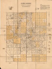
Map - JACK FLYNN COLLECTION: GIRGARRE, 14/10/1943
Map: Parish of Girgarre , County of Rodney. Parish plan. Same map as 10100.20 but in poorer condition.By Authority, H.E.Daw, Government printer Melbourne. Drawn and Reproduced at the Dept, of Lands and Survey, Melbourne, Victoriamap, rodney, girgarre, girgarre, county of rodney -
 Bendigo Historical Society Inc.
Map - JACK FLYNN COLLECTION: GIRGARRE, 14/10/1943
Map: Parish of Girgarre. County of Rodney. Parish plan.By Authority, H.E. Daw, Government Printer Melbourne. Drawn and produced at the Dept of Lands and Survey, Melbourne, Victoria. 14.10.1943map, rodney, parish plan, girgarre, county of rodney -
 Bendigo Historical Society Inc.
Map - JACK FLYNN COLLECTION: GIRGARRE, 1957
Map: Township of Girgarre, Parish of Kyabram, County of Rodney. Parish plan.By Authority: W. M. Houston, Government Printer, Melbourne. Drawn and reproduced at the Department of Lands and Survey, Melbourne.map, rodney, township, girgarre -
 Bendigo Historical Society Inc.
Map - JACK FLYNN COLLECTION: ECHUCA NORTH, November 1953
Map: Echuca North, County of Rodney. Parish plan.By Authority: W.M. Houston, Government Printer. Drawn and Reproduced at the Dept., of Lands and Survey Melbourne, Victoria. November 1953map, rodney, parish plan, echuca north rodney -
 Bendigo Historical Society Inc.
Map - JACK FLYNN COLLECTION: BURNEWANG, 17/09/1918
Map: Parish of Burnewang, County of Rodney. Parish plan.By Authority, H. J. Green, Acting Government Printer Melbourne. Photo Lithographed at the Department of Lands and Survey, Melbourne by W. J. Butson.map, rodney, parish plan, burnewang, rodney -
 Bendigo Historical Society Inc.
Map - JACK FLYNN COLLECTION: BONN, 16/07/1919
Map: Parish of Bonn, County of Rodney. Parish plan.By Authority A. J. Mullett. Government Printer, Melbourne. Photo Lithographed at the Department of Lands and Survey. Melbourne by W. J. Butson.map, rodney, parish plan, bonn, rodney -
 Bendigo Historical Society Inc.
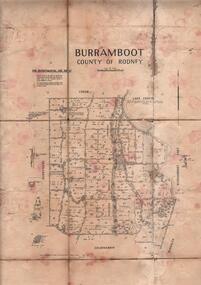
Map - JACK FLYNN COLLECTION: BURRUMBOOT, August 1951
Map: Parish of Burrumboot, County of Rodney. Parish plan.By Authority J.J. Gourley, Government Printer Melbourne. Drawn and Reproduced at the Dept of Lands and Survey, Melbourne, Victoria. August 1951map, rodney, parish plan, burrumboot, rodney -
 Bendigo Historical Society Inc.
Map - JACK FLYNN COLLECTION: BEALIBA, 15/09/1931
Map: Parish of Bealiba, County of Gladstone. Parish plan.By Authority H.J. Green, Government Printer. Photo Lithographed at the Government of Lands and Survey Melbourne. 15.9.31map, gladstone, parish plan, bealiba, gladstone -
 Bendigo Historical Society Inc.
Map - JACK FLYNN COLLECTION: ARCHDALE, 15/01/1936
Map: Parish of Archdale, County of Gladstone. Parish plan. The Allotments have been coloured in with pencil.By Authority H.J. Green, Government Printer Melbourne. Drawn and Reproduced at the Dept, of Lands and Survey, Melbourne, Victoria. 15/01/36map, gladstone, parish plan, archdale , gladstone -
 Bendigo Historical Society Inc.
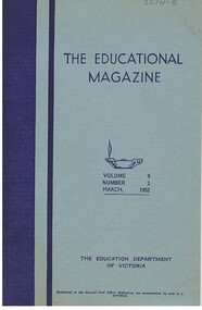
Magazine - NORMAN PENROSE COLLECTION: THE EDUCATIONAL MAGAZINE, 1952
Document. Norman Penrose collection: light blue cover with dark blue spine and a vertical blue stripe. Contains information for teachers and articles relating to teaching. The Educational Magazine Volume 9, Number 2, March 1952.The Education Department of Victoria. By Authority: J.J. Gourley, Government Printer, Melbourne.government, state, educational magazine, norman penrose collection, the educational magazine -
 Bendigo Historical Society Inc.
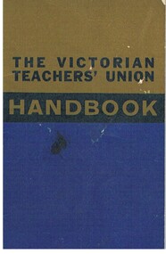
Document - NORMAN PENROSE COLLECTION: THE VICTORIAN TEACHERS' UNION HANDBOOK, 1965
Document. Norman Penrose collection: the Victorian Teacher's Union Handbook 1965 edition. Contains information, rates of pay, etc for teachers. Blue book, with khaki at the top and a darker background behind 'Handbook'.Victorian Treachers Union 20 Bank Place, Melbourne. Printed by Mylund Press Pty Ltd., 289 Bank St., S. Melb., Vic.government, state, victorian teachers union handbook, norman penrose collection, the victorian teachers' union handbook'. -
 Bendigo Historical Society Inc.
Map - JACK FLYNN COLLECTION: COHUNA, 1963
Map: Photocopy of parish plan showing Cohuna and a portion of the Gunbower Creek.By Authority. A.C. Brooks Government Printer, Melbourne. Drawn and Reproduced at the Department of Lands and Survey, Melbourne.1963.map, gunbower, parish plan, cohuna , gunbower creek -
 Bendigo Historical Society Inc.
Map - JACK FLYNN COLLECTION: KARA KARA, 1932
Map: County of Kara Kara, map sheet showing the whole of the County of Kara Kara and all of the Parishes within. Scale 2 miles to 1 inch.By Authority: W.M. Houston, Government Printer Melbourne. Department of Lands and Survey, Melbourne, 1958map, kara kara, county, kara kara -
 Bendigo Historical Society Inc.
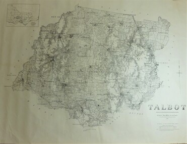
Map - JACK FLYNN COLLECTION: TALBOT, 1937
Map: County of Talbot, map sheet showing the whole of the County of Talbot and all of the Parishes within. Scale 2 Miles to 1 inch.By Authority: A.C. Brooks, Government Printer, Melbourne. Department of Lands and Survey Melbourne. 1959map, talbot, county, talbot