Showing 2059 items
matching hawthorn east
-
 Bialik College
Photograph (Item) - Tapestry photographs, 1997 Tapestry unveiling photographs
... Bialik College 429 Auburn Road Hawthorn East 3123 melbourne ...In 1997, Bialik College students of Grades 4, 5 and 6 co-designed with a weaver, Cresside Collette, a large tapestry depicting Bialik students holding hands and the school motto 'Step forth with courage'. Images of this important message and community moment are held by the Bialik archive. If you have materials or stories about Bialik life and culture that you wish to please contact us at [email protected]. weaving, artwork, bialik college, judaism, jewish school, primary school -
Bialik College
Photograph (Item) - Shakespeare Grove 1963 to 1998 celebrations
... Bialik College 429 Auburn Road Hawthorn East 3123 melbourne ...Shakespeare Grove 1963 to 1998 celebrations occurred after Bialik kindergarten was moved to the Auburn Road location. The photographs show children, staff, and community members at various events, such as singing and viewing displays of children's work from various years at the junior school. For inquiries or access contact [email protected] date print 29 November 1998school, jewish school, bialik college, photographs., celebration, shakespeare grove -
Bialik College
Photograph (Item) - Various primary school incursions
... Bialik College 429 Auburn Road Hawthorn East 3123 melbourne ...Two photographs show that, in 1993, 8 February, a few students actively participated in an incursion where they were shown, and allowed to touch, a small swordfish snout, a taxidermy seal and the skull of an unidentified creature. On 28 October 1993 Senior Citizens came to Bialik for a visit. Three photographs capture the moment a beekeeper brought in a hive and shared protective gear with children. For inquiries or access contact [email protected] side on some images have brief descriptions. 1993 Senior Citizens Visit Bialik in red pen. Sense of wider community is written in black pen on the reverse of the images of the beekeeper. school, jewish school, bialik college, photographs., incursion, animals, community outreach, senior citizens -
Bialik College
Photograph (Item) - Family and friends skill share
... Bialik College 429 Auburn Road Hawthorn East 3123 melbourne ...These photographs capture the moments when parents, carers and friends of children attending Bialik came into the school to share their skills. Images show some people cooking in a classroom. Most of the photographs show upper-level primary school children being instructed in a wood-work room. c 1992-1993 For inquiries or access contact [email protected] date marking: 20 August 1992 and 9 August 19931990s, 1992, 1993, school, jewish school, bialik college, photographs. -
Bialik College
Photograph (Item) - School Musical misc and Hans Christian Anderson, nd
... Bialik College 429 Auburn Road Hawthorn East 3123 melbourne ...No date, estimated to be the L1990s, E2000s, showing various students in multiple musical performances. One is named as Hans Christian Anderson with primary school children. For inquiries or access contact [email protected], jewish school, bialik college, photographs., musical -
Bialik College
Photograph (Item) - Kinder Farm Visits, c1990s
... Bialik College 429 Auburn Road Hawthorn East 3123 melbourne ...Approximately 1990s various kinder classes from Bialik attended a farm. Children are showing holding a chicken and feeding sheep. For inquiries or access contact [email protected], jewish school, bialik college, photographs., excursion, kindergarten -
 Bialik College
Photograph (Item) - Grade Four Camp, nd, Regional Victoria
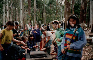
... Bialik College 429 Auburn Road Hawthorn East 3123 melbourne ...Primary school aged children attend a school camp in regional Victoria. Some images are of a riverboat and others at Sovereign Hill heritage park. Other images were taken in a forest environment as students cook on bbq. For inquiries or access contact [email protected] side of some of the photographs have 'grade 4 camp' or 'g4' inscribed in blue pen. 1990s, 2000s, camp, school, jewish school, bialik college, photographs. -
Bialik College
Photograph (Item) - Grade 5 camp, c1990s
... Bialik College 429 Auburn Road Hawthorn East 3123 melbourne ...Estimated to be 1990s of a grade five camp. Students and teachers are shown relaxing in a shared indoor space, a beachside space, and a few individual images. For inquiries or access contact [email protected] side of the images have inscriptions 'Jean Year 5 Camp', 'tired teachers on year five camp', and lists students from 5D. 1990s, camp, grade 5, school, jewish school, bialik college, photographs. -
Bialik College
Photograph (Item) - Various school year events, named, 1990s-2000s
... Bialik College 429 Auburn Road Hawthorn East 3123 melbourne ...These photographs show a variety of year levels, across the 1980s and 1990s, children and staff partaking in foundational community activities at Bialik. From a French Soiree, to fruit and milk sharing in kinder classes, these images capture the core, repetitive, activities that occur in a typical Bialik school year. For inquiries or access contact [email protected] reverse sides show, in order of appearance: Bet with students for Riding 6 kms Backwards Day, Students teach teachers, curriculum, accepting others, fostering school community (milk & fruit kinder), dramatic play curriculum teaching, Soiree, Succot?, curriculum, Yr 10s Play for kinder, kinder visit from police man, dramatic play, Holocaust Day, bike day kinder, breakfast at school, Yr 3 and Year 8 Writing Workshop, curriculum reading party. 1980s, 1990s, school, jewish school, bialik college, photographs -
Bialik College
Photograph (Item) - Special friends and buddies
... Bialik College 429 Auburn Road Hawthorn East 3123 melbourne ...Primary school level children partake in 'special friends' and 'buddy system' events. The children involved are from Prep, Grade 2 and Grade 6. Activities took place in the school yard and school library. No date listed, possibly late 1990s to mid-2000s. For inquiries or access contact [email protected] side of the photographs state brief descriptions like, Prep/Year 2 buddy system, special friends PS, Special friends prep-6, special friends cross age group learningprimary school, school, jewish school, bialik college, photographs -
Bialik College
Photograph (Item) - Bialik Excursions, post-1990s
... Bialik College 429 Auburn Road Hawthorn East 3123 melbourne ...Photographs are from various excursions that Bialik students attended. They range from upper school students in urban environments to primary school in regional spaces. Children are seen getting on and off buses, lined up as a group and in the Channel 9 tech spaces. For inquiries or access contact [email protected] photographs have brief inscriptions on the reverse, excursion, channel 9. Digital stamp on one image 8 November 1993school, jewish school, bialik college, photographs, excursion -
Bialik College
Photograph (Item) - Bnei Mitzvah 1993
... Bialik College 429 Auburn Road Hawthorn East 3123 melbourne ...Images of students involved with Bialik's Bnei Mitzvah Program. In 1993 the program was organised together with Jewish Welfare and National Council of Jewish Women. Photo taken outside Caulfield Synagogue where our students were invited to the NCJW senior citizens group's meeting. For inquiries or access contact [email protected] larger images have 'bnei mitzvah' inscribed on the back. The smaller image inscription states Bnei Mitzvah Program 1993 (black pen) Josie. This program is organised together with Jewish Welfare and National Council of Jewish Women. Photo taken outside Caulfield Synagogue where our students were invited to the NCJW senior citizens group's meeting (blue pen). bnei mitzvah, jewish culture, school, jewish school, bialik college, photographs -
Bialik College
Photograph (Item) - Bialik Staff
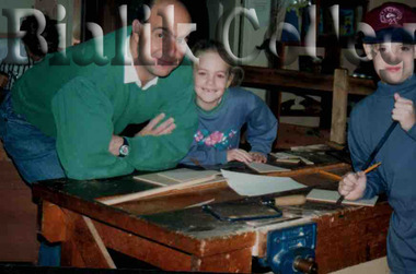
... Bialik College 429 Auburn Road Hawthorn East 3123 melbourne ...Various photographs showing the variety of skills held by Bialik teachers, including and beyond the classroom and office. One is a teacher with a piglet, another playing a clarinet, some working in an office space, and others working with students. For inquiries or access contact [email protected] inscriptions, in order of appearance: Teachers with special skill.teaching, staff, professionals, school, jewish school, bialik college, photographs -
 Bialik College
Photograph (Item) - The community and parents of Bialik
... Bialik College 429 Auburn Road Hawthorn East 3123 melbourne ...The community of parents, grandparents, family and friends offer much support to students. These photographs, ranging from the late 1980s to early 2000s, show the generations and groups that partake in moments of classroom visits, a wedding, working bees, and festival days . For inquiries or access contact [email protected] images have inscriptions on the reverse, such as: school community, electives parent involvement, parents inclusion, electives parent participation, parents house, Parents' night L-R Rodney Nissen Michael Warren, L-R Alan & Karen Kozica, Susie Cohen, support, mother on duty (no name).family, community, school, jewish school, bialik college, photographs -
Bialik College
Photograph (Item) - Integration and inclusion processes
... Bialik College 429 Auburn Road Hawthorn East 3123 melbourne ...The photographs were taken c1980s to 2000s. They show children working together in formalised co-operative programs within the school. Integration, inclusion, electives, co-operative learning, assessment, non-english speaking, older and younger, Gruelle teaching strategy, unique skills of teacher, in-services science, mixed ability teaching and working as a team, support child working with a group, and Yooralla Disability awareness are a scope of events recorded. Mostly primary school aged children, the photographs captured moments of speeches, creative play, dramatic performances, sharing food and outside play. One digital date stamp shows this as being taken 4 February, 1993. For inquiries or access contact [email protected] images have an inscription on the reverse in a range of handwriting types. Some examples are: integration, inclusion, electives, co-operative learning, assessment, non-english speaking, older and younger, Gruelle teaching strategy, unique skills of teacher, inservices science, mixed ability teaching and working as a team, support child working with a group, Yooralla Disability awareness. One digital date stamp shows this as being taken 4 February, 1993classroom, outdoor, school, jewish school, bialik college, photographs, 1990s, 1980s, 2000s -
Bialik College
Photograph (Item) - Kinder Days
... Bialik College 429 Auburn Road Hawthorn East 3123 melbourne ...Kinder children at Bialik are shown at various events, partaking in sand play, birthday celebrations, and reading time. c1993 For inquiries or access contact [email protected], 1993, school, jewish school, bialik college, photographs -
Bialik College
Photograph (Item) - Oliver , the musical, school Camp c1993, Oliver, the musical, school Camp c1993
... Bialik College 429 Auburn Road Hawthorn East 3123 melbourne ...C1993 Bialik students performed the musical, Oliver. Part of the creation and preparation period involved a multi-grade creative camp. A range of inscriptions that are on the back of many photographs show the diverse activities that took place as a Music teacher developed the character of Fargin, Shabbat at musical camp, aerobics and numerous cross age activities. For inquiries or access contact [email protected] range of inscriptions appear on the back of many photographs in blue pen, Teachers on Camp-Jean, Music teacher developing a character for "Oliver"- Fargin. Older and younger children together. Musical camp school common, musical rehearsal, Shabbat at musical camp, Oliver Camp, Year 4 taking aerobics at Oliver camp, First Aid at Oliver Camp, Simulation activity Oliver camp, Cross age activity, Year 4 teacher at Oliver camp. school, jewish school, bialik college, photographs., performing arts, musical -
Bialik College
Photograph (Item) - Grade six camp c1990s-2000s; Music Ensemble 2000, Grade six camp c1990s-2000s
... Bialik College 429 Auburn Road Hawthorn East 3123 melbourne ...A large group of grade six students are together on a beach, near the scrub going inland. A camp event, many of the students are playing in the edges of the water. No date is listed or indicated clearly. Music Ensemble 2000 contain group photographs of students in music department with staff. There are no names included. For inquiries or access contact [email protected] image reverse side has in blue pen written Year 6 school campbeach, camp, grade 6, 1990s, school, jewish school, bialik college, photographs -
Bialik College
Photograph (Item) - Bialik in the 1990s
... Bialik College 429 Auburn Road Hawthorn East 3123 melbourne ...Various events that occurred at the Bialik primary school levels from 1992-1994. Children are seen in dress-ups of superheroes and pirates, wearing winter clothes, doing actions as a group, playing twister, painting and playing group sports. For inquiries or access contact [email protected] photographs have minimal to no inscriptions on them. The digital marks indicate they were taken in various months from 1992 to 1994school, jewish school, bialik college, photographs, primary school, 1990s, 1992, 1993, 1994 -
Bialik College
Photograph (Item) - Puppets in the classroom
... Bialik College 429 Auburn Road Hawthorn East 3123 melbourne ...Bialik children are shown moving large puppets around the classroom, guided by two older women, possibly teachers or helpers. No date is indicated, but clothing indicates late 1990s to early 2010s.For inquiries or access contact [email protected] on one photograph, written in black penart and design department, school, jewish school, bialik college, photographs -
Bialik College
Photograph (Item) - PJ Day in the Primary School
... Bialik College 429 Auburn Road Hawthorn East 3123 melbourne ...Lower primary school children pose for photographs dressed in their nightclothes. No names or dates. For inquiries or access contact [email protected] has no-context 'S.'dress-up, school, jewish school, bialik college, photographs -
Bialik College
Photograph (Item) - Speech delivery, c1993
... Bialik College 429 Auburn Road Hawthorn East 3123 melbourne ...Upper school children stand alone, or in pairs, at the front of the classroom. They look to be delivering a speech or talk. Some are dressed in uniform, others in more formal wear.No date or other details are available. [email protected], jewish school, bialik college, photographs -
Bialik College
Photograph (Item) - Bialik junior school 1994
... Bialik College 429 Auburn Road Hawthorn East 3123 melbourne ...Photographs that were taken in association with the 1994 school year at Bialik, showing students at incursions, excursions, singing, dancing, doing classroom work, playing outside, and in music classes. For inquiries or access contact [email protected] and year, 1994music, excursion, 1990s, 1994, incursion, animals, clowns, schoolwork, bialik -
Bialik College
Plaque - In appreciation 10th anniversary concert
... Bialik College 429 Auburn Road Hawthorn East 3123 melbourne ...In appreciation 10th anniversary concert, no further details. Please contact [email protected] to request access to this record. concert, bialik, judaism -
Bialik College
Functional object (Collection), Yom Ha'atzmaut 2000s
... Bialik College 429 Auburn Road Hawthorn East 3123 melbourne ...3 cd-rom labeled Yom Ha'atzmaut 2000syom ha'atzmaut, judiasm, bialik college, jewish lifeyom ha'atzmaut, judiasm, bialik college, jewish life -
Bialik College
Photograph (Item) - Photographs of class room teaching via set programs
... Bialik College 429 Auburn Road Hawthorn East 3123 melbourne ...c1990s education programs as run at Bialik at primary school grade levels. For access or queries contact [email protected], bialik, students, classroom -
Bialik College
Photograph (item) - Years 5 and 6 Soccer Team, 1996, 1996
... Bialik College 429 Auburn Road Hawthorn East 3123 melbourne ...Years 5 and 6 Soccer Team, 1996. Please contact [email protected] to request access to this record.sport, 1990s -
Bialik College
Photograph (item) - Years 7 and 8 Touch Football Premiers, 1996, 1996
... Bialik College 429 Auburn Road Hawthorn East 3123 melbourne ...Years 7 and 8 Touch Football Premiers, 1996. Please contact [email protected] to request access to this record.sport, 1990s -
Bialik College
Photograph (item) - Years 7 and 8 EIS Touch Football Team 1996, 1996
... Bialik College 429 Auburn Road Hawthorn East 3123 melbourne ...Years 7 and 8 EIS Touch Football Team, 1996. Please contact [email protected] to request access to this record.sport, 1990s -
Bialik College
Photograph (item) - Years 7 and 8 Boys Handball Team, 1996, 1996
... Bialik College 429 Auburn Road Hawthorn East 3123 melbourne ...Years 7 and 8 Boys Handball Team, 1996. Please contact [email protected] to request access to this record.sport, 1990s