Showing 969 items
matching homesteads
-
 Wodonga & District Historical Society Inc
Functional object - Large Pinking Shears, Comete Ninci, 1948
Pinking shears or scissors were a valuable accessory for any professional or home dressmaker. Pinking shears have serrated edges and they leave trimmed fabric with a decorative edge as well as preventing the fabric from fraying. The words under the trademark "Marque Depose" mean trademark pending. These pinking shears were owned by Mrs. Betty Sheather of Gordon Street, Wodonga, Victoria. Betty was the daughter of James and Elizabeth Fletcher. Her father had many jobs including carriage cleaner with Victoria Railways at Wodonga and her mother was at House Creek State School No. 2266. Betty worked in Arnold's Store, the store of Costelloe & Smith as well as the Bethanga Park homestead as well as Drummonds at Walwa and the Hotel at Ebden. As a younger woman she lived with the Whan family at Stonleigh which was then a rope factory.Betty was a keen golfer and belonged to a club which played at the Wodonga Racecourse and was a member of the Bandiana Golf Club. These shears were owned by a well-known member of Wodonga and were representative of dressmaking implements used in the mid 1900s.Large vintage Comete Pinking Shears / zigzag scissors produced in Italy from metal alloy.On outer side of blade : NINCI COMETE 1948. Beside central hinge in ring shape: COMETE/ITALY/NINCI/ MARQUE DEPOSE.pinking shears, dressmaking -
 Federation University Historical Collection
Document - Documents, History of the Coghill Family
History of the Coghill Family from the 1700s.Typed and handwritten papers relating to the Coghill Family. Part ot the handwritten history "The Coghill Family - 13-9-40 Statement by Mr Henry Holmes of Essendon" includes the following: (Page 1) "The original Captain Coghill owned Glendaruel and Glendonald Stations (the homestead of the latter was Andrew Munro's original home.) He had five sons and two daughters ... William Coghill Jnr, a son of Captain Coghill married Miss Catherine Dorothy Holmes. They had no family and they adopted William and Henry Holmes, their nephews, who were the sons of Edward Carer Holmes, brother of Mrs William Coghill Jnr. ... (Page 2 - does not run on from page1)coghill, pioneer family, land settlement in victoria, new south wales, captain john coghill, donald john coghill, will of william coghill senior, indenture agreement, david coghill, william baldwin, talbot, elizabeth coghill, margaret coghill, christina coghill, george coghill, helen coghill, john coghill, catherine dorothy holmes -
 Mt Dandenong & District Historical Society Inc.
Photograph, The Valley of the Harmony Vale Settlement c1910, 1973
Scene looking across the valley of Harmony Vale from Barbers Road. c1910. Photograph copied by John Lundy-Clarke in 1973. This photograph has a detailed inscription on the back handwritten by John Lundy-Clarke in 1974.The valley of the Harmony Vale settlement on the Olinda Creek from Barbers Road. "Shiloah" on far left centre. John William Richardson's home among trees left of centre. Homestead Harmony Vale above log yard (see below) and among orchard trees. Child Bros sawmill and log yard with logs among trees above flat cultivation right of centre. Bert Childs home beyond "Harmony Vale". Lucas' "Glenrivers" is in gully above main clearing centre top left. Frank Childs home among trees centre of picture. Taken about 1910 by Rose Series. Copied 1974 JLC.kalorama, harmony vale, olinda creek, barbers road, shiloah, sawmill, child, bert child, glenrivers -
 Ringwood and District Historical Society
Document, An excerpt of the account book from Charles Newman 1860-1893, including marriage certificate of Mary Ann Newman, daughter of Charles, to Edward Richard Crosswell
An excerpt of the account book from Charles Newman 1860-1893, including marriage certificate of Mary Ann Newman, daughter of Charles, to Edward Richard Crosswell on 13 July 1865 at St Paul’s Church, Melbourne. Major Charles Newman (1795-1866) had one of the first pastoral holdings east of Melbourne in the 1830s. It was located around the confluence of the Yarra River and the Mullum Mullum (or Deep) Creek. The family built the historic, and heritage-listed, Pontville Homestead, constructed in the 1840s and still there today. Caroline Madden, who married Nicholas Madden, one--time owner of the Coach & Horses Hotel, was the daughter of Edward Crosswell. -
 Phillip Island and District Historical Society Inc.
Photographs, mid 2008
A collection of photographs donated by Meg Davis (nee McHaffie) relating to the Lonely Grave site in Ventnor and the McHaffie family.A collection of 8 coloured photographs relating to Capt. Grossard's Grave Site and the McHaffie family. 272-01. Photograph of Fiona McCarthy and Julie Box planting a Norfolk Pine at the Lonely Grave, Grossard Point, Ventnor, Phillip Island 272-02. Photograph of Fiona McCarthy and Meg Davis planting a Norfolk Pine at the Lonely Grave, Grossard Point, Ventnor, Phillip Island 272-03. Photograph of the Lonely Grave Memorial Plaque re Capt Grossard's accidental death. 272-04. Photograph of a Memoral Plaque commemorating the first settlement on Phillip Island by the McHaffie family 272-05. Photograph closeup of the above Memoral Plaque. 272-06. Photograph of the Memorial Plaque of the Gravesite of Capt. W. P. Grossard who died 17th December 1868. 272-07. Photograph closeup of the above. 272-08. Photograph of a brown glazed pot supposed to be from the McHaffie homestead site in Ventnor, Phillip Island.capt grossard, the lonely grave at grossard point, mchaffie family, meg davis, julie box, fiona mccarthy -
 Orbost & District Historical Society
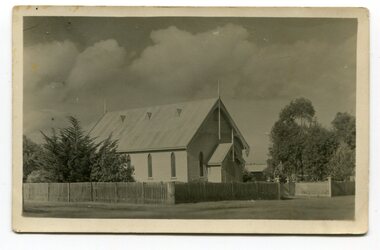
black and white photograph, Empire Post Cards, C 1940s
"The first Presbyterian Church service was conducted at the Orbost Station Homestead in 1885, during a visit by Sir William Clarke, who was accompanied by two ministers. The organist was resident Grace Jennings Carmichael. Services were later held in Mr J. W. Borland’s shop and the Mechanics Hall. In 1887, the land on which the church now stands was purchased from Mr James Hossack snr, for £50 ($100). The trustees were Mr John, Peter and Hugh Cameron, Mr John A Watt and Mr James Hossack Jnr. Timber from Richardson’s Tabbara Mill was used by builder Mr R. P. Cameron and at a cost of £311.3.7 ($622) the church was opened January 9th 1898." (from Newsletter 90 Margaret Smith) In 1928 the Sunday School hall was added to the church. Mr R.P. Cameron was the contractor for both the manse and the church. The first communion service was held on July 17 1892. the Presbyterian Church was commenced in Orbost in 1855 when the Reverend Chas Attwood was settled in pastoral charge.This is a pictorial record of the Presbyterian Church in Orbost as it was in the mid 20th century. It is now the Orbost Uniting Church hall, known as St Andrews Hall,A black /white postcard photograph of the Orbost Presbyterian Church, a wooden structure with a wooden picket fence at the front and trees on right and left sides. on back - " H Gap, Presbyterian Church Orbost"presbyterian-church-orbost religion -
 Eltham District Historical Society Inc
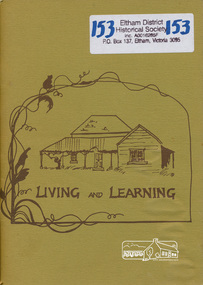
Book, Clipper Press, Living and Learning, 1977
Shire of Eltham Living and Learning Centre is located at 739 Main Road, Eltham. The purpose of the Centre is: To provide an opportunity to come together individually and in groups in an atmosphere of equality, sharing their skills and experiences in order to improve the quality of their living. Tutors are not paid and fees are not charges on the understanding that the idea of sharing and co-operating spreads and everyone enjoys the results. This book was compiled by volunteers involved at the centre recording feelings, views of their experiences within the groups at the centre. It includes recipes, poems, stories and sketches, some of local scenes. It also includes an early history of the Centre compiled by the first Co-ordinator. Subjects include enrolment day, bee keeping, Bridge Club,Carpentry and woodcarving, looking and sharing, creative dancing, crochet, dressmaking, film making, Friends of the Creek, Diamond Creek, accessibility, hair cutting, herb gardening, home handyman skills, homestead cooking, living with goats, native plants, North Riding Project, gardening, painting, playhouse, play reading, puppetry, sculpture, spinning, weaving, winemaking and yoga. This book is significant in documenting the early history of the Eltham Living and Learning centre including the concepts of community co-operation and life-long learning for adults. It connects the current users of the Centre and the wider community with this local history which is part of the character represented in the twentieth century history of the Eltham area. Softcover [64] p.eltham living and learning centre, co-operative, education -
 Glen Eira Historical Society
Document - Christian Family
Six documents on the Christian Family. Nine typed pages by Robert Trumble dated 08/02/1974. Extracts taken from two books written by him about the Christian family in Australia. Three pages about Thomas Christian and Myoora from Caulfield Historical Society Newsletter April/June 1974. Handwritten notes on Thomas and Violet Christian from 1886-1891, possibly taken from Rate Books, unsigned and undated. Handwritten information from the Public Record Office Victoria giving extract of register of Wills, Vol.W1, page 39 Christian, Thomas. Unsigned and undated. Photocopied UK incoming passenger list dated 28/04/1899 showing Mrs. Christian, eight children and maid on the ship Wakool, from Ancestry.com.au Newspaper item dated 26/01/2013 from the Saturday Age mentioning Coolart Homestead, late Victorian mansion, owned at one stage by Tom Luxton who was married to Gertrude Christian.christian thomas, christian violet mary, christian dorothy, christian emily, barclay frank, baker blanch miss, christian florence, trumble hugh, christian arthur james, christian may, player charles dr., llaneast, house names, player janet, player alison, player dorothy, myoora, christian gertrude, christian grace, richards henry caselli, richards harry, trumble robert, trumble kathleen, christian dorothy, dandenong road, caulfield, luxton thomas j., trumble ken, christian edgar john, emery irene, the golden age of cricket, the trumble family in australia, dunstan john r., o’donnell j., caulfield historical society, alma road, hawthorn road, dandenong road, craigellachie, orrong road, p.c. day dawn, p.c. gold mining company ltd., charters towers, mines and mining, gold mining, balconies, verandahs, cast iron work, towers, stained glass, mansions, ievers william, pfeiffer frederick, newmann violet mary, lloyd john charles, architects, brooke family, servants, stairs, teacher work, cellars, flats, slate tiles, roofs, chimneys, fireplaces, land subdivision, coach houses, reed henderson and smart (architects), wills, ships, wakool, henderson anketell -
 Southern Sherbrooke Historical Society Inc.
Information folder - Glen Park
Folder containing information pertaining to the history of Glen Park homestead, Menzies Creek. Contents: -two pages photocopied from "That Little Train" by Peter Cuffley, showing four photos of Glen Park homestead and a short history of Edwin Johns at Glen Park (2 copies of each) -articles, "No. 861's full steam ahead again", photo shows Col Rees with Coonara Community School students, and "Living the dream" re. engine no. 861. On verso, "A Family Reunited", article by Emerald Tourist Railway re. locomotives, and "Colin just loves steam locomotion" re. engine no. 861. -4 letters, from Puffing Billy Railway, in support of Col Rees. -Letter, dated 19 June 1996, from Emerald Tourist Railway, re. appeal for restoration of Garratt engine. On verso, copy of certificate awarded to Col Rees for donation to appeal. -Letter, 1 June 1998, re. Garrett appeal. On verso, certificate awarded to Col & Kellie Rees for donation to appeal. -Aerial photo showing proposed property boundaries of Glen Park subdivision. -Aerial photo showing existing property boundaries of Glen Park. NB. last four items provided to society by Col Rees in support of subdivision. -Memorandum dated 2 May 2000 from Graham Whitt, Shire of Yarra Ranges, to Shire Service Centres, re proposed division of Glen Park land. -Fax, dated 13 June 2000, from Southern Sherbrooke Historical Society to Shire of Yarra Ranges, re. intention to make submission. -Letter, dated 14 June 2000, acknowledging receipt of above fax. -Submission, dated 18 June 2000, from Southern Sherbrooke HS, expressing concern re. proposed subdivision of Glen Park. -Fax, dated 27 June 2000, from Dianne Kueffer to Susan Heywood-Downard, Agenda Item 2 of the Yarra Ranges Planning Committee Agenda 14 March 2000, including detailed description of proposed subdivision and map. -Letter, dated 7 July 2000, Shire to Society, re. discussion of Glen Park subdivision by council. -Letter, dated 7 July 2000, Society to Shire, re. withdrawal of objection subject to certain conditions. -Letter, dated 14 July 2000, Shire to Society, re. council resolution to allow subdivision of Glen Park. -Letter, dated 24 October 2000, Shire to Society, stating that amendment to Planning Scheme allowing subdivision was approved by council and gazetted on 19 October 2000. -seven A3 sheets, showing house and property plans for new constructions proposed for Lot 1 of Glen Park subdivision. -diagram, hand-drawn (by Col Rees?) on lined A4 sheet, showing proposed development. -A1 sheet, Plan of feature survey of Lot 2 Blackhill Rd, Selby, dated 12 April 2000, showing contours, vegetation, proposed location of buildings, etc. -Glen Park Homestead and Cyprus Avenue, document prepared for the Shire Of Yarra Ranges by Helen Lardner Conservation & Design P/L, June 2003edwin johns, breen family, col & kellie rees, puffing billy -
 Eltham District Historical Society Inc
Slide, "Kangaroo Hall" (c.1843-1969), Donaldsons Road, Kangaroo Ground, which was destroyed during the January 8, 1969 bushfire; c.1975, 1975c
Built by James and Isabella Donaldson at the centre of their 1 square mile property southwest of the present day Presbyterian Church. The Donaldsons first arrived in Port Phillip on 17 December 1841. Their first house was a bark hut which was replaced by this substantial brick home around the mid 1840s. James Donladson died 1856. Kangaroo Ground Presbyterian Church http://kgpc.pcvic.org.au/history-2.html Pictures of the farm and homestead (rented by Mr E. Hobson) were published in The Weekly Times, 18 March 1911, p27 1911 'MR. E. HOBSON'S FARM AT KANGAROO GROUND.', Weekly Times (Melbourne, Vic. : 1869 - 1954), 18 March, p. 27. , viewed 29 Feb 2020, http://nla.gov.au/nla.news-article222243528 A letter from Mr Hobson published in the following edition clarified that he only rented the property and that the owner was Mr John Donaldson of Sandringham 1911 'KANGAROO GROUND.', Weekly Times (Melbourne, Vic. : 1869 - 1954), 25 March, p. 47. , viewed 29 Feb 2020, http://nla.gov.au/nla.news-article22224117935 mm colour positive transparency Mount - Agfacolor Service (Blue)bushfire, donaldson home, donaldsons road, isabella donaldson, james donaldson, kangaroo ground, kangaroo hall, victorian bushfires - 1969 -
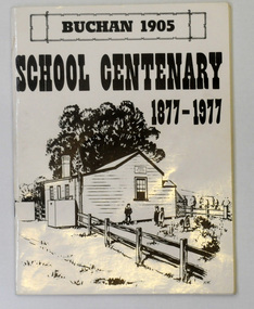 Orbost & District Historical Society
letter book, James Yeates & Sons (Printing) Pty Ltd, 1977
This book was prepared for the Buchan School centenary. In the Buchan District itinerant teaching was conducted in buildings with log walls and a bark roof typical of the mid 19th century. Not until 1878 was the first State school built on the same general site as the present school, on the Orbost Rd, ⅓ of a mile from the bridge over the Buchan River. This original school building must have been constructed from high quality timber, because it still serves as the shelter pavilion. On 11th of July 1878 William Scott opened the first school of approximately 40 pupils ranging from Grade 1 - 8. A larger weatherboard school was erected in 1914. A residence was provided for the HT in 1934 and in 1956 a second classroom erected and attached to the 1914 building. Unfortunately, all records of the Committee were lost in a fire when the homestead of Alex Cameron, then serving as Committee Secretary, was burnt to the ground, but it is well known to local citizens that Frank Moon, local prospector, explorer and discoverer of the famous Buchan Limestone Caves, attended school at SS1905 Buchan. (ref SCHOOLS EAST GIPPSLAND - John Phillips)This book is a useful research tool on the history of Buchan.Two copies of a 273 pp paper covered booklet. The cover is white with the title in black print. On the front is a sketch of an old school building. On the back is a black/white photograph of children running downhill. A book on the history of the Buchan school no.1905. Includes photographs, maps and lists of school students and staff.book buchan-history buchan-school -
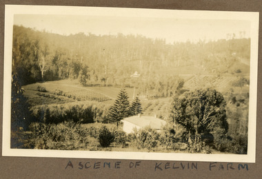 Mt Dandenong & District Historical Society Inc.
Photograph
Most likely a scene of 'Mt Calvin', the homestead built by John William (Willie) Richardson for his wife Jeanie Green of Wandin. The house was built c1898 The Rowse family purchased the house and 60 acres when Willie and Jeanie Richardson with their 3 children moved to Brisbane. The Rowse family farmed the 60 acres for 35 years and the house was demolished in 1938. The photograph is from the album of Ivy May Child. Ivy May Child (1910 – 1989) was the daughter of Arthur Edward (Ted) Child (1878 – 1964) and Ethel May Madden (1888 – 1970). Ted Child was the son of Matthew Francis Child (1839 – 1933) and Martha Jeeves (1857 – 1926). He was the grandson of one of the early pioneers Francis Child. Ivy grew up on the family property on Childs Road and took many photographs. Most of these are glued into her photo album. The album covered the years from c1927 – 1932. Ivy married Henry William Burgess (1906 – 1968) in 1944. The photographs remain in their original state in the album with individual copies made. Black and white photograph with a house in the foreground looking over cultivated fields with treed hills in the background. A building is visible in the centre in the distance.Written below the photograph in the album" A SCENE OF KELVIN FARMmt calvin, kelvin farm, calvin farm, richardson, rowse, jeanie richardson, john william richardson, willie richardson -
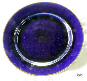
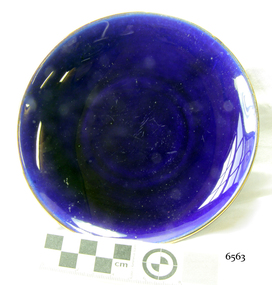 Flagstaff Hill Maritime Museum and Village
Ceramic - Saucer, 1920s
This saucer is part of a four-piece place setting, comprising a teacup, saucer and plates, from a tea set. The tea set was given by Eva Carmichael, one of only two survivors of the ship Loch Ard which was wrecked near Port Campbell in 1878, to Jane Shields, the young woman who supported Eva during her recovery from the ordeal. Ms Shields was Eva’s close companion while she was convalescing at Glenample Homestead. The friendship between the two women continued after Eva Carmichael returned to her home in Britain, became Mrs Townsend, and had three sons. Jane Shields also married, becoming Mrs John Osborne and bearing four daughters and two sons. n 1926-27, almost forty-eight years after the shipwreck, one of Jane’s daughters (Ella Marie Schulz nee Osborne) visited Eva in England. Eva gave her the tea set to take back home to her mother. Jane died in 1932 and her tea set was inherited by her daughters, who divided it between themselves, a four-piece place setting for each of them. This blue ceramic tea set, comprising a teacup, saucer and two plates, is of high significance as it is closely connected to the wreck of the Loch Ard, and one of only two survivors, Eva Carmichael. Memorabilia connected to Eva Carmichael are precious and rare. The Loch Ard shipwreck is significant for Victoria and is registered on the Victorian Heritage Register (S 417). Flagstaff Hill has a varied collection of artefacts from Loch Ard and its collection is significant for being one of the largest accumulations of artefacts from this notable Victorian shipwreck. The collection gives a snapshot of history, enabling us to interpret the story of this tragic event and the lives of the people involved. The collection is also archaeologically significant as it represents aspects of Victoria's shipping history that allow us to interpret Victoria's social and historical themes of the time. The collection's historical significance is that it is associated unfortunately with the worst and best-known shipwreck in Victoria's history.Saucer; this saucer is part of a ceramic tea set place setting, comprising a cup, saucer and two plates of slightly different sizes. The saucer is royal blue with a gold rim.warrnambool, maritime-museum, flagstaff-hill-maritime-village, loch ard, shipwreck, tea set, ceramic, flagstaff hill, flagstaff hill maritime museum and village, shipwreck coast, great ocean road, royal blue china, eva carmichael, jane shields, glenample, place setting, saucer, ceramic tea set -
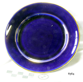 Flagstaff Hill Maritime Museum and Village
Ceramic - Plate, 1920s
This plate is part of a four-piece place setting, comprising a teacup, saucer and plates, from a tea set. The tea set was given by Eva Carmichael, one of only two survivors of the ship Loch Ard which was wrecked near Port Campbell in 1878, to Jane Shields, the young woman who supported Eva during her recovery from the ordeal. Ms Shields was Eva’s close companion while she was convalescing at Glenample Homestead. The friendship between the two women continued after Eva Carmichael returned to her home in Britain, became Mrs Townsend, and had three sons. Jane Shields also married, becoming Mrs John Osborne and bearing four daughters and two sons. In 1926-27, almost forty-eight years after the shipwreck, one of Jane’s daughters (Ella Marie Schulz nee Osborne) visited Eva in England. Eva gave her the tea set to take back home to her mother. Jane died in 1932 and her tea set was inherited by her daughters, who divided it between themselves, a four-piece place setting for each of them. This blue china tea set, comprising a teacup, saucer and two plates, is of high significance as it is closely connected to the wreck of the Loch Ard, and one of only two survivors, Eva Carmichael. Memorabilia connected to Eva Carmichael are precious and rare. The Loch Ard shipwreck is significant for Victoria and is registered on the Victorian Heritage Register (S 417). Flagstaff Hill has a varied collection of artefacts from Loch Ard and its collection is significant for being one of the largest accumulations of artefacts from this notable Victorian shipwreck. The collection gives a snapshot of history, enabling us to interpret the story of this tragic event and the lives of the people involved. The collection is also archaeologically significant as it represents aspects of Victoria's shipping history that allow us to interpret Victoria's social and historical themes of the time. The collection's historical significance is that it is associated unfortunately with the worst and best-known shipwreck in Victoria's history. Plate; this plate is part of a ceramic tea set place setting, comprising a cup, saucer and two plates of slightly different sizes. The plate is a royal blue colour with a gold rim.flagstaff hill, warrnambool, flagstaff hill maritime museum and village, shipwreck coast, great ocean road, ceramic tea set, plate, tea set, royal blue china, eva carmichael, jane shields, glenample, loch ard, place setting, coffee cup plate -
 Flagstaff Hill Maritime Museum and Village
Ceramic - Plate, 1920s
This plate is part of a four-piece place setting, comprising a teacup, saucer and plates, from a tea set. The tea set was given by Eva Carmichael, one of only two survivors of the ship Loch Ard which was wrecked near Port Campbell in 1878, to Jane Shields, the young woman who supported Eva during her recovery from the ordeal. Ms Shields was Eva’s close companion while she was convalescing at Glenample Homestead. The friendship between the two women continued after Eva Carmichael returned to her home in Britain, became Mrs Townsend, and had three sons. Jane Shields also married, becoming Mrs John Osborne and bearing four daughters and two sons. In 1926-27, almost forty-eight years after the shipwreck, one of Jane’s daughters (Ella Marie Schulz nee Osborne) visited Eva in England. Eva gave her the tea set to take back home to her mother. Jane died in 1932 and her tea set was inherited by her daughters, who divided it between themselves, a four-piece place setting for each of them. This blue china tea set, comprising a teacup, saucer and two plates, is of high significance as it is closely connected to the wreck of the Loch Ard, and one of only two survivors, Eva Carmichael. Memorabilia connected to Eva Carmichael are precious and rare. The Loch Ard shipwreck is significant for Victoria and is registered on the Victorian Heritage Register (S 417). Flagstaff Hill has a varied collection of artefacts from Loch Ard and its collection is significant for being one of the largest accumulations of artefacts from this notable Victorian shipwreck. The collection gives a snapshot of history, enabling us to interpret the story of this tragic event and the lives of the people involved. The collection is also archaeologically significant as it represents aspects of Victoria's shipping history that allow us to interpret Victoria's social and historical themes of the time. The collection's historical significance is that it is associated unfortunately with the worst and best-known shipwreck in Victoria's history.Plate; this plate is part of a ceramic tea set place setting, comprising a cup, saucer and two plates of slightly different sizes. The plate is a royal blue colour with a gold rim.flagstaff hill, warrnambool, flagstaff hill maritime museum and village, shipwreck coast, great ocean road, ceramic tea set, plate, tea set, royal blue china, eva carmichael, jane shields, glenample, loch ard, place setting -
 Ringwood and District Historical Society
Mixed media - Video, RDHS Guest Speaker Presentation - "Heathmont 2020 Highlights" - Gerry Robinson and Peter Le Get
Digitised video (1.11GB). Duration: 20 minutes. Recorded March, 2021. (Video is available for viewing at Ringwood & District Historical Society Archives by appointment)Presenters: Gerry Robinson and Peter Le Get of Heathmont History Group (HHG) look back over developments in the area over the previous year. HEATHMONT HIGHLIGHTS FOR 2020 Summary - "Of course for 2020 the Covid 19 virus dominated. Other finalists included roadworks on Bedford Road corner, new Wards for MCC and their elections, 100th birthday and death of Rita James, opening of Milk & Wine Co. café replacing Barclays, election of Kylie Spears as Mayor, closure of Heathmont Medical Centre, demolition of Miller homestead in Coven Avenue, final edition of Maroondah Leader local newspaper, opening of HE Parker Sports pavilion, 50 more bollard arts, and the ugliness of the former Anglican Church and other local sites." -
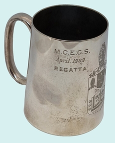 Wodonga & District Historical Society Inc
Functional object - Silver Mug - K. D. Watson, Wodonga
This cup was awarded to Kenneth Darnton Watson when he was a boarder and competitive rower whilst completing his secondary education. Kenneth Darnton Watson was born at Bendigo on 24 May 1893 to George Darnton Watson and Adelaide Nora Holmes. He was educated at Melbourne Church of England Grammar School, being selected as School Captain in 1913 and a member of the Head of the River rowing team. After finishing school, he worked as a jackaroo on Wanganella Station and later at Mt. Widderin, Skipton, Victoria. When WW1 was declared, Kenneth enlisted and after initial training at Maribyrnong, Victoria he left Australia as 2nd Lieutenant with 7th Australian Field Artillery Brigade, to disembark at Plymouth on July 10, 1916. He took part in the Battles of Messines, Menin Road, Polygon Wood and Passchendaele Ridge in 1917. For his efforts in Passchendaele Ridge on 17th December he was awarded the Military Cross "for conspicuous gallantry and devotion to duty." In 1918 he took part in the Battles of Villers-Bretonneux, Hamel and Amiens. He returned to Australia in November 1919 and was discharged on 20th January 1920. In 1922, Kenneth Darnton Watson came to Wodonga where he purchased de Kerilleau Homestead, consisting of 2,500 acres, from Mr George Gordon. The two storey brick homestead had been built by William Huon in 1870. On 30th May 1924, he married Phyllis Emily Lenore Austin and they had four children, Ian Darnton 1925, Robert Darnton 1926 Rosemary McPherson 1929 and Faith Holmes 1931. On the land Kenneth worked hard, building fences, cattle, sheep and horse yards, and farmed Corriedale sheep, Shorthorn cattle and horses. he was an innovative farmer, introducing modern methods of top dressing at de Kerilleau by means of an aircraft. He was also a dedicated community man. He was a member of both Albury and Wodonga Show Committees, Murray Valley Development League, No.1 Region, Graziers' Association of Southern Riverina, Albury Legacy Club, Wodonga RSL, and Wodonga Turf Club including terms as President on several of these organisations. Kenneth was also a Warden of St. Luke's Church of England, Wodonga. Kenneth served as Wodonga Shire President from 1929 to 1931, and was again elected to Council from 1943 to 1945. A most respected and valued member of the local community, Kenneth Darnton Watson died on the 4th of October 1951, aged 58. Lenore Watson lived at de Kerilleau until her death on 15th June 1984. Both are buried in Wodonga.These images are significant because they record the service of a prominent member of the Wodonga community.A silver mug awarded to K D Watson as a rowing trophy in April 1909. It features the shield of Melbourne Church of England Grammar School (M.C.E.G.S.), as well as his name and the event for which it was awarded.View 1: M.C.E.G.S. April 1909 Regatta View 2: Crest of MECEGS featuring motto "Ora et Labora" View 3: BOARDERS FOUR K. D. WATSON 3kenneth darnton watson, watson family wodonga, wodonga community members -
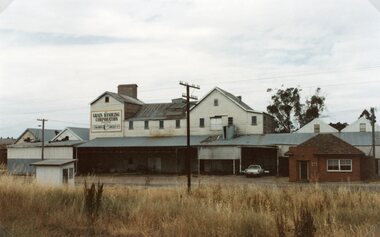 Stawell Historical Society Inc
Photograph, Wimmera Flour Mill during Demolition -- Coloured
Various colour photos of Wimmera Flour Mill at time it was being demolished. Note roof being dismantled. Rail line in foreground. Willaim Frayne founded the Wimmera Flour Mill on a site in Taylor Street (beside the railway line) Stawell 1876. When Willian Frayne dies 1899 his son George took over the mill. The mill continued to be a propriety company until early 1966, when it was sold to the Victorian Mill Owners. The sale was forced because of the lack of export markets. A factor which affected most country mills. The Victorian Oat Growers Pool took over on July 1st, 1967. Trading under the name of Wimmera Flower Mill as a subsidiary company. Later years it sold clipped and graded seed, oats, stockfeed for poultry, pigs and dairy cattle and all types of crushed grain. The original Frayne homestead still stands behind where the Mill stood facing Frayne Street. In 2007 during our "Collection Review" the four smaller colour photos, which were donated by Mr. Mick Walsh, 52 Patrick St Stawell were very similar to the bigger photo in the file 139.6e.139-6 a-d & e Coloured photographs showing various views of the Wimmera Flour Mill or Grain Handling Corporation building in progress of being demolished. There is a red brick building with a tiled roof in these coloured photos. The rail line is shown in foreground of 139-6 e. Our records on the data base show 139-6e to be a black & white photo but the same photo in the office folder is an enlarged colour photograph. Grain Handing Corporation stawell industry -
 Mt Dandenong & District Historical Society Inc.
Photograph, Post Office and 'Mountjoy', Mt. Dandenong North, 1913
Rose Series post card #182Copy of Rose Series postcard #182 showing Kalorama Gap in 1913. Haystacks in foreground with Mountjoy Guest House and Beulah Tea Rooms/Mt Dandenong North Post Office in centre. This photograph has a detailed inscription on the back handwritten by John Lundy-Clarke in 1974.Kalorama Gap in 1913 The elm trees are in the centre of the picture. One of these is really two as two suckers of the further tree were twisted together by Fred Jeeves in 1898 and grew as one tree. The other was planted in 1880. The shop is the shop of Mrs Eliza Hand and daughter Florence. The closed in far end of the verandah was the Mount Dandenong North Post Office. The large house is “Mountjoy” owned and run by the Jeeves Family from 1908 till 1943. It was built in 1905 by the Paynters who sold to Ellis Jeeves in 1908.He moved his line of coaches from “Kalorama” his old homestead and housed the horses in a line of stables behind “Mountjoy”. Price’s house, which contained their shop, the first one on the mountain, opened 1906, can be seen faintly behind the pine tree opposite the bend in the road, which was the main road then and now is Ridge Road. The Price’s house just shows in two tiny pieces, one on each side of the pine tree half way up. The house to the right of and high up the pine tree is Walker’s cottage which exists today opposite Jack Kidd’s home at the far edge of Lt 2 Village Settlement and was between Main Road and Barbers Road which runs down the left behind the elms. Walker’s homestead can be seen near left edge of picture 2/3 way up. The roof of the Methodist Church shows among trees left of picture. This, like Mrs Hand’s shop was built on portions separated from Isaac Jeeves’ Selection “C” known as Jeeves Saddle. kalorama gap, five ways, mountjoy, john lundy-clarke, beulah tea rooms, post office, fred jeeves, paynter, jeeves, frederick jeeves, price, walker, jack kidd -
 Orbost & District Historical Society
black and white photograph, 1930 - 1940
This photograph shows three generations of the Russell family in Orbost. On the left is John Russell with his son Bill Russell and his wife Ede and their son Ian. John Russell Senior was a blacksmith, wheelwright, farmer and chairman of the Orbost Butter Factory, makers of Sunny South Butter (today part of Murray Goulburn Co Ltd). Bill was born at Orbost in 1893, the youngest son of John and Elizabeth Maud (nee Clarke). Upon his father’s retirement he took over the homestead part of the holding, 1,000 acres of river flats and hill land. He was involved in dairying and was also a successful beef cattle breeder and maize grower. He was elected to the Orbost Shire Council in 1929 and shortly afterwards was President for 18 months (from May 1930 to August 1931). He served a further term as President in 1934-35. He represented the South riding. He was chairman of the Bean Board and a well-known horse and show judge and a member of the Royal Agricultural Society. He was an elocutionist of some note and a member of the committee of management of the Orbost Hospital. He was also a prominent member and Past Master of the Masonic Lodge and a Justice of the Peace. He served as president of the Orbost Golf Club and assisted with the preparation and layout of the present Orbost Golf course. This item is associated with the Russell family, early settlers in the Orbost district.A black / white photograph of a family. A lady is in the middle with a man on each side and a young boy in front. They are standing outside a house in the garden.on back - "3 generations, Johnny Russell, Ede & Bill Russell & Ian Russell"russell-family-orbost -
Federation University Historical Collection
Document - Reports, Martin Westbrooke, Nanya Station
Nanya Station, owned and managed by the University of Ballarat (now Federation University Australia), was purchased with assistance from the Department of Environment and Heritage Government Caring for our Country program. Nanya Station is located in the Scotia country, west of the Darling Ana-Branch in far western New South Wales and consists of the Nanya Western Lands Pastoral Lease 3281 – Perpetual Leasehold Lot 1244 in Deposited Plan 762778, Parish of Winnebaga, County of Tara and part of Lot 1242 County of Windeyer. Nanya is within the tribal area of the Danggali Aboriginal people, a sub-group of the Barkindji. Many Aboriginal sites have been recorded adjacent to major rivers in the region providing evidence that these areas supported a large population. The Scotia region has one of the shortest stock grazing histories of western NSW. Along with five other Scotia properties, Nanya was created as a pastoral lease in 1927. The first European settlement on the land followed exploration of the area by Sturt and Eyre. In 1854, the Lake Victoria lease which encompassed this area comprised 465,000ha.included Scotia blocks 1, 2, 3 and 4, Amoskeag and Winnebaga which formed the area known as the Scotia. It was described as a region of thick mallee scrub, interspersed with bluebush flats and Belah woodland. In the 1920s artesian water was found and the dry Scotia country was surveyed and divided into six Homestead leases allocated by ballot (Withers 1989). All properties were approximately 30,000ha, with a recommended stocking level of 3,000 sheep. Winnebaga (renamed Nanya) was taken up by Gordon Cumming. He initially dug a dam near the southeast corner of the property. A larger ground tank and rudimentary dwelling at the site of the present complex was later established. An adjacent area was cleared and cropped to provide feed for the horses used in digging the earth tanks. The ruins of the original building are located between the shearing shed and Homestead Tank. A cottage was built in the 1930s and a more substantial Red Gum framed homestead in the early 1950s. The lease was held by Mr Gordon Cumming until 1984 when it was purchased by Mr Norm Scadding as an extension to the adjacent lease, Belvedere. It was sold in 1995 to Mr Rob Taylor of Waikerie then in 1999 to BeMax Pty. Ltd., a sand mining company. These last three owners all permitted use of the property by the University for teaching and research. The Centre for Environmental Management at the University of Ballarat had been involved in studies of flora and fauna in western New South Wales since 1988. Studies became concentrated on the Scotia region with its variety of intact ecosystems due to a short pastoral history. Of particular significance is a system of natural salt lakes of which the most extensive is the Scotia Discharge Complex located on Nanya Station. An extensive vegetation survey of the Scotia region Westbrooke et al. 1998) highlighted the significance of the area both in terms of the range of communities in relatively intact condition and the occurrence of species and communities of restricted distribution. Nearly 400 species were recorded of which nine had either not previously been recorded or have restricted distribution in western NSW. Twenty-two plant communities occur on Nanya Station of which two, Halosarcia lylei low open shrubland and Hemichroa diandra/Halosarcia/Frankenia low open shrubland, are dominated by species not previously recorded from NSW. H. lylei and Acacia loderi shrublands are listed as endangered under the NSW Threatened Species Conservation Act. As noted, the area has a relatively short grazing history and, due to the presence of large areas of mallee with a Triodia understorey and restricted water supplies, stocking rates have been low. The diversity of ecosystems in relatively intact condition and extensive areas of old growth mallee made Nanya a highly significant refuge for biological diversity. This factors led to the purchase of Nanya Station by the University of Ballarat in 2004 with the assistance of the Department of Environment and Heritage for the purposes of conservation, research and education. In 2010 the southern paddocks of Nagaella Station (10,000ha.) which lie along the northern boundary, were purchased with the assistance of Lower Murray Darling Catchment Management Authority and added to the Nanya lease to provide complete protection for the communities of the Nanya Discharge Complex and further high quality Malleefowl habitat. Four digital reports documents relating to Federation University's Nanya Station, Western New South Walesnanya station, scotia country, pastoral lease, winnebaga county, darling ana-branch, martin westbrooke, environmental education, nagaella station, lower murray darling catchment management authority, conservation research education, ian gribble, pat prevett, ian henderson, danggali