Showing 1101 items
matching information map
-
 Ballarat Tramway Museum
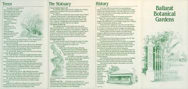
Pamphlet, City of Ballarat, "Ballarat Botanical Gardens", April 1985
The pamphlet provides information about the "Ballarat Botanical Gardens" - its history, trees, notable areas and Statuary. Includes a map which has references back to the text. Dated April 1985Yields information about the Ballarat's Botanical Gardens within in which the tramway museum operates.Pamphlet - 4 fold DL printed green ink.city of ballarat, lake wendouree, ballarat botanical gardens, botanical gardens, map -
 Ballarat Tramway Museum
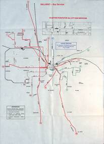
Map - Public Transport Map - Bus, Ministry of Transport, Ballarat, Bendigo & Geelong, 1977
Set of three maps, c1977 show the bus routes for each of Ballarat, Bendigo and Geelong along with railways. Provides information on each route, summary timetables, who operated the route and places of interest. Published by the Ministry of Transport in conjunction with the Transport Regulation Board, Bus Proprietors Association and VicRail. By comparison with the posters issued at the time of tram closure, can see the changes made to the routes in each city. See item 6813 for Ballarat, 6812 for Geelong, and 6814 for Bendigo.Demonstrates a public transport map published by the Ministry of Transport.Set of three 10 fold maps printed in colour to pocket size.On each map "7/77" in ink.buses, maps, ballarat, bendigo, geelong, timetables, railways -
 Ballarat Tramway Museum
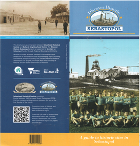
Pamphlet, Sebastopol Historical Society, "Discover Historic Sebastopol", 2024
"Discover Historic Sebastopol" - a guide to historic sites in Sebastopol. Has a map of locations or sites of interest, introduction, includes notes on trams, Royal Mail Hotel and the last tram. Published by Sebastopol Historical Society and the Ballarat Neighbourhood Centre with design by Peter Lambert Design.Yields information about the history of the Sebastopol district.Pamphlet - 36 pages, colour stapled, DL size.sebastopol, local history, tramways -
 Ballarat Tramway Museum
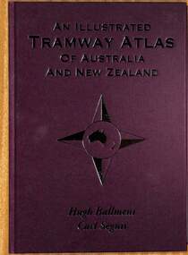
Book, Hugh Ballment and Carl Segnit, "An Illustrated Tramway Atlas of Australia and New Zealand", 2018
Yields information about the extent and cities that had street tramway systems in Australia and New Zealand and in particular Ballarat.Book - hard cover, 9 sewn sections, full paper bound front covers, 120 pages, gloss paper printed in full colour titled "An Illustrated Tramway Atlas of Australia and New Zealand" with a table of contents by Hugh Ballment and Carl Segnit published by Transit Australia, 2018. Has a preface and acknowledgements, lists 23 Australian and 9 New Zealand cities that had public street tramway systems. Gives maps of the Tramway Museums at the time, trams on public displays and tramway museums that have closed. The Map for the Ballarat Tramway Museum line in Wendouree Parade is not correctly shown.trams, tramways, atlas, australian tramways, ballarat, maps, geelong, bendigo -
 Bendigo Historical Society Inc.
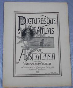
Journal - Picturesque Atlas of Australasia
The Picturesque Atlas of Australasia was released in 42 supplements between 1886 and 1889 and attracted over 50,000 subscribers. Produced by the Picturesque Atlas Publishing Company in Wynyard Square, Sydney. The company was established in 1885. Edited by Andrew Garran. For detailed information search the website of the National Library of Australia. Thirty-three parts. Volume 9 to Volume 42. Volumes 1 - 8 and 28 are missing. Light tan coloured covers have a printed central rectangular double border. The title and publication information and illustrations are printed inside the border. The illustrations included are Captain Cook, a sailing ship and a sprig of wattle. The pages include many black and white illustrations. Volume 16 Separate map of Fiji. This Volume covers Bendigo as one of Victoria's country towns Volume 27 Includes separate Railway, Postal and telegraph map of Queensland. Volume 42 This last Volume contains a Miscellaneous section at the back with an Editorial Postscript and two maps - Australia and The Solar System.australasia, flora and fauna, subscription, history, exploration -
 Bendigo Historical Society Inc.
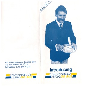
Ephemera - "Bendigo Bus" new routes, 1960 -1970s
BHS CollectionGlossy Brochure introducing "Bendigo Bus" new routes. Map of the new routes and information hotline.history, bendigo, merle lummis collection, bendigo bus -
 Bendigo Historical Society Inc.
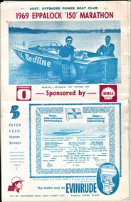
Document - AULSEBROOK COLLECTION: 1969 EPPALOCK '150' MARATHON BOOKLET, 1969
Aulsebrook Collection: 1969 Eppalock '150' Marathon Booklet -large booklet cover (a) - (which is loose), -8 page inside stapled booklet -booklet filled with various advertisements, lists of officials (b), comments/articles from people involved, information about the types of races, lsits of people involved, map of race, -
 Ballarat Tramway Museum
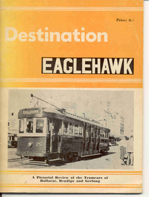
Book, Traction Publications et al, "Destination Eaglehawk", 1965
Details the history of the SEC Provincial TramcarsBook, 48 pages, "Destination Eaglehawk", with card covers, printed, with photographs, brief review of history of Ballarat, Bendigo and Geelong SECV Tramcars with some notes on the tramway systems themselves. No maps. Published by Traction Publications Canberra 1965, dedicated to Wal Jack.non-fictionDetails the history of the SEC Provincial Tramcarstramcars, ballarat, geelong, bendigo, provincial tramways -
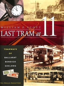 Ballarat Tramway Museum
Book, William. F. Scott, "Last Tram at Eleven - Tramways of Ballarat, Bendigo Geelong", 2008
Extensive history on the foundation of the three Victorian Provincial tramways, operations, tramcar lists and relationship to their private operation and power stations.. Foreword by Professor Weston Bate Yields detailed information about the history of the three SEC Provincial systems, in particular the construction history and their tramcars.Book - 212 pages on art paper with a gloss finish applied to photographs, sewn with glued end papers, folded dust jacket or cover titled "Last Tram at Eleven - Tramways of Ballarat, Bendigo Geelong". Written by William F Scott, published by Full Parallel Productions 2008. Has a cloth book mark. Has a Table of Contents, Index, many photographs, maps, liststramway history, ballarat, bendigo, geelong, tramcars, trams -
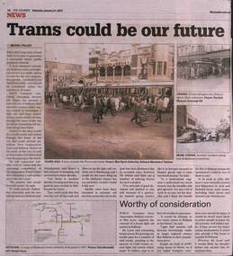 Ballarat Tramway Museum
Newspaper, The Courier Ballarat, "Trams could be our future", 21/1/2017
Article by Michael Pollock reporting on a letter to the City of Ballarat about a proposal by Mr Jeff Moran of AWTY Transort Consultants about building a light rail system to serve Ballarat growth areas. Outlines possible routes. Was supported by Mr Bob Lever of the local PTUA. Has photos of a large crowd joining bogie trams outside the Provincial Hotel and two photos of tram accidents. along with a map of the SEC System.Yields information about a proposal to provide light rail to Ballarat.Newspaper cutting from The Courier, Ballarat, 21/1/2017 titled "Trams could be our future".trams, tramways, tram revival, light rail, ballarat, tramway proposals -
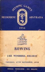 Ballarat Tramway Museum
Programme, 1956 Olympic Games, Rowing Programme Lake Wendouree, Ballarat
The 1956 Melbourne Olympics saw the rowing events held on Lake Wendouree Ballarat. This was only set of events held outside Melbourne Region. The Programme, lists the scoreboard abbreviations, the Games Committee, map of the course, Rowing events Committee and Council, Officials, each event, finalists, names position, previous winners, transport services, though did not include Ballarat trams and on the rear cover a simplified programme of events and a map and list of competition venues. Cover printed by Sands McDougall Pty Ltd Melbourne with text by Alex King & Sons Pty Ltd Ballarat. Two contestants of interest are Murray Riley and Mervyn Wood who came 3rd in the double sculls. Wood became the NSW police commissioner in 1977 and Riley was a corrupt NSW Policemen and after leaving the police force became highly involved in the Nugan Hand Bank which was highly involved in drug trafficing, and crime syndicates. See reference.Yields information about the Rowing Events on Lake Wendouree in 1956. The trams were an important transport service to and from central Ballarat for this event.Book - 20 pages, centre stapled, titled "1956 Olympic Games, Melbourne Official Rowing Programme Lake Wendouree, Ballarat" and printed specifically for Tuesday 27 November 1956.All event results have been filled in with the list of countries and their times.olympic games, transport, ballarat, rowing, lake wendouree, events -
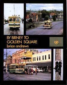 Ballarat Tramway Museum
Book, Brian Andrews, "By Birney to Golden Square", 1973
Features both black and white and colour photographs, including tickets, photos along each route, Charing Cross, depot, notes on the rolling stock with an aerial photograph of Bendigo with the tram routes marked in and a fold out detailed map of Bendigo and its track layout.Yields information about the Bendigo tramways operated by the SEC in a photographic and text format.Book, 78 pages including card cover, printed on gloss paper, titled "By Birney to Golden Square", written by Brian Andrews, published by Southern Cross Traction, Kensington Park SA. Sub-titled "The last last years of Bendigo's tramways", 1973. trams, tramways, bendigo, sec tramways, maps -
 Ballarat Tramway Museum
Document - Manuscript, Peter J Barry, "Signalling and Operations on the Tramway System in Bendigo", April 1990
Draft of an article with notes/additions by Keith Kiings on the signalling system and tramcar operations in Bendigo. Looks at the basic services, crossing loops, signalling, following movements (Bendigo used a white disc on the tram to indicate a following tram, Ballarat did not use this system), short workings, reversals, observations of actual workings. Includes a map drawn by Keith Kings in 1972. Published in the September 1990 issue of Somersault, by the Signalling Record Society of Victoria.Yields information about the operation of the Bendigo tramway system using the Forest City Signalling system.Six A4 pages of a draft of an article by Peter Barry and correspondence to Keith Kings re "Signalling and Operations on the Tramway System in Bendigo, April 1990.tramways, trams, bendigo, signalling, forest city, operations, crossing loops, srsv -
 Ballarat Tramway Museum
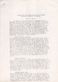
Archive - Notes on Fort Collins Municipal Railway, Wal Jack, c1950
Wal Jack kept extensive notes on railways and tramways around the world, provided by his correspondents and research. This sheet gives details of the Fort Collins Municipal Railway in Colorado USA. The 7.5mile system operated a small fleet of Birney type tramcars. Includes a map of the system. Bickarts were Ballarat Watchmakers and Jewellers.Yields information about type of work undertaken by Wal Jack.Orange colour quarto sheet on the rear of Bickarts' letterhead providing Notes on Fort Collins Municipal Railwayletters, wal jack, archive, usa, records, bickarts, fort collins, birney tramcars -
 Ballarat Tramway Museum
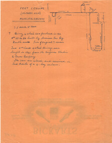
Drawing, Coventry City Corp Tramways
Wal Jack had an extensive range of correspondents throughout Australia and the world who often provided him with detailed drawings and notes on various tramway systems. Drawing shows the various lines, crossing loops, depots, routes with numbers and the location of bomb damage during 1940 air raids. The gauge of the system was 3'6". The Wikipedia reference reports that the system was closed as a result of extensive damage during the air raids. Not known who prepared the drawing.Yields information about Wal Jack's correspondents and their extensive work.Drawing - red and black ink on quarto paper, Coventry tramway system.letters, wal jack, drawings, maps, coventry, uk. -
 Ballarat Tramway Museum
Drawing - Map or Plan, Wanganui Tramways NZ, 1945
Wal Jack had an extensive range of correspondents throughout Australia and the world who often provided him with detailed drawings and notes on various tramway systems. Drawing shows the various lines both railways and tramways, crossing loops, locations and features of the Wanganui NZ tramway system in 1945. Drawn by an unknown person; has an initial in the bottom right hand corner.Yields information about Wal Jack's correspondents and their extensive work.Drawing - red and black ink, colour pencil on foolscap paper of Wanganui Tramways NZ 1945letters, wal jack, drawings, maps, wanganui nz -
 Ballarat Tramway Museum
Drawing - Plan and notes, Wal Jack, Auckland NZ tramways, 1945
Wal Jack had an extensive range of correspondents throughout Australia and the world who often provided him with detailed drawings and notes on various tramway systems. This set of notes on the Auckland tramway system, both the main city, Auckland Tramway Board and the north shore - Takapuna Tramway and Ferry Co shows the various routes, locations and terminals. The hand written sheets provide opening dates of the various routes and gives the total miles and number of cars as at 31-3-1945. Based on the handwriting, prepared by Wal Jack himself.Yields information about Wal Jack's extensive recording and research work.Set of two drawings - black, red and blue ink on quarto size paper and two sheets of notes on the Auckland tramway system c1945.letters, wal jack, drawings, maps, auckland, takapuna nz -
 Ballarat Tramway Museum
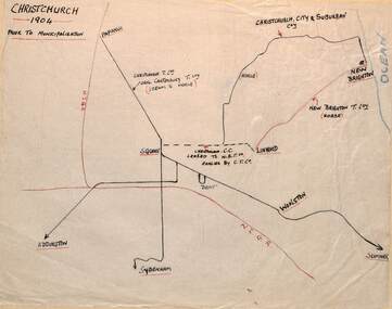
Drawing - Christchurh NZ - Plan and Notes, Wal Jack, 1947
Wal Jack had an extensive range of correspondents throughout Australia and the world who often provided him with detailed drawings and notes on various tramway systems. This set of notes on the Christchurch tramway system, provides details of the tram system prior to being taken over by the City and afterwards. Plan dated 30-6-1947. The hand written sheets provide details of the routes and the rolling stock. Based on the handwriting, prepared by Wal Jack himself. Yields information about Wal Jack's extensive recording and research work.Set of two drawings - black, red and blue ink on quarto size paper and three sheets of notes on the Christchurch tramway system 1947tramways, christchurch nz, wal jack, drawings, maps, tramcars -
 Ballarat Tramway Museum
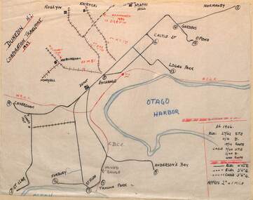
Drawing - Dunedin NZ - Plan and Notes, Wal Jack, 1946
Wal Jack had an extensive range of correspondents throughout Australia and the world who often provided him with detailed drawings and notes on various tramway systems. This set of notes on the Dunedin tramway system, provides details of the tram system during 1946 and the rolling stock. Based on the handwriting, prepared by Wal Jack himself. Yields information about Wal Jack's extensive recording and research work.Drawing - black, red and blue ink or colour pencil on quarto size paper and one sheet of notes on the Dunedin NZ tramway system 1946.tramways, wal jack, drawings, maps, tramcars, dunedin nz -
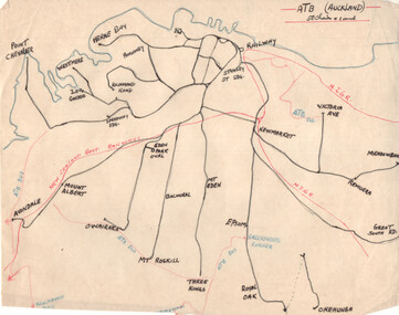
 Ballarat Tramway Museum
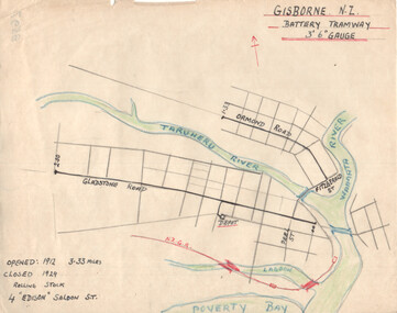
Drawing - Gisborne NZ - Battery Tramway - plan, Wal Jack, c1946
Wal Jack had an extensive range of correspondents throughout Australia and the world who often provided him with detailed drawings and notes on various tramway systems. This drawing shows the small battery-powered (four) tramcar system in Gisborne NZ. Shows the NZ rail line, rivers and the length of each route, and the dates of operation. Based on the handwriting, prepared by Wal Jack himself. Yields information about Wal Jack's extensive recording and research work.Drawing - black, red and blue ink or colour pencil on quarto size paper of the Gisborne NZ tramway system.tramways, wal jack, drawings, maps, tramcars, gisborne nz -
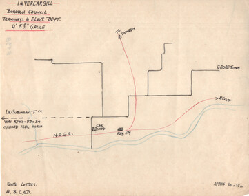 Ballarat Tramway Museum
Drawing - Invercargill NZ - Plan and Notes, Wal Jack, 1947
Wal Jack had an extensive range of correspondents throughout Australia and the world who often provided him with detailed drawings and notes on various tramway systems. This set of notes on the Invercargill tramway system, provides details of the tram system and a list of the rolling stock and track length. Based on the handwriting, prepared by Wal Jack himself. Yields information about Wal Jack's extensive recording and research work.Drawing - black, red and blue ink or colour pencil and a second sheet, both on quarto paper providing details of the Invercargill NZ tramway system.tramways, wal jack, drawings, maps, tramcars, invercargill -
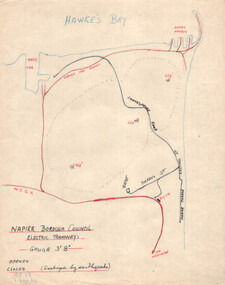 Ballarat Tramway Museum
Drawing - Napier NZ - Plan and Notes, Wal Jack, c1947
Wal Jack had an extensive range of correspondents throughout Australia and the world who often provided him with detailed drawings and notes on various tramway systems. This set of notes on the Napier NZ tramway system provides details of the tram system and a list of the rolling stock. Notes that the system was destroyed by an earthquake, but he did not know the opening and closing dates at the time of preparation. The reference states that the system operated from 1913 to 1931. Based on the handwriting, prepared by Wal Jack himself. Yields information about Wal Jack's extensive recording and research work.Drawing - black, red and blue ink or colour pencil and a second sheet, both on quarto paper providing details of the Napier NZ tramway system.tramways, wal jack, drawings, maps, tramcars, napier -
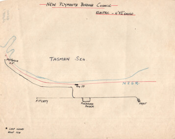 Ballarat Tramway Museum
Drawing - New Plymouth NZ - Plan and Notes, Wal Jack, c1947
Wal Jack had an extensive range of correspondents throughout Australia and the world who often provided him with detailed drawings and notes on various tramway systems. This set of notes on the New Plymouth NZ tramway system provides details of the tram system and a list of the rolling stock. Based on the handwriting, prepared by Wal Jack himself. Yields information about Wal Jack's extensive recording and research work.Drawing - black, red and blue ink or colour pencil and a second sheet, both on quarto paper providing details of the New Plymouth NZ tramway system.tramways, wal jack, drawings, maps, tramcars, new plymouth nz -
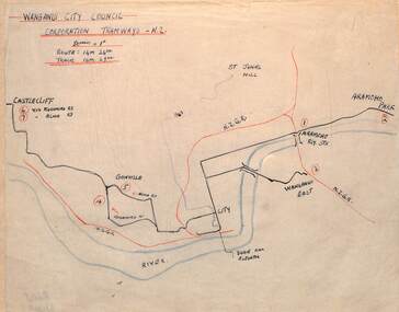 Ballarat Tramway Museum
Drawing - Wanganui NZ - Plan and Notes, Wal Jack, 12/1946
Wal Jack had an extensive range of correspondents throughout Australia and the world who often provided him with detailed drawings and notes on various tramway systems. This set of notes on the Wanganui tram system and a list of the rolling stock dated Dec. 1946. The typed foolscap sheet listing the trams or rolling stock gives details on each tram. May have been used to prepare Wal's list. Map and the handwritten list of trams, based on the handwriting, prepared by Wal Jack himself. The typed list may have been prepared by others. Yields information about Wal Jack's extensive recording and research work.Drawing - black, red and blue ink or colour pencil, one hand written sheet and one double sided typed carbon copy foolscap sheet with ink notes over poor sections of type.tramways, wal jack, drawings, maps, tramcars, wanganui -
 Ballarat Tramway Museum
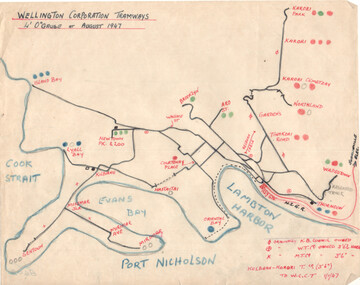
Drawing - Wellington NZ - Plan and Notes, Wal Jack, August 1947
Wal Jack had an extensive range of correspondents throughout Australia and the world who often provided him with detailed drawings and notes on various tramway systems. This set of notes on the Wellington NZ tram system provides a list of tramcars, track layout and general notes. Dated August 1947. Based on the handwriting, prepared by Wal Jack himself. Yields information about Wal Jack's extensive recording and research work.Drawing - black, red and blue ink or colour pencil and two quarto sheets hand made.tramways, wal jack, drawings, maps, tramcars, wellington nz -
 Ballarat Tramway Museum
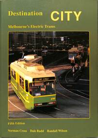
Book, Traction Publications, "Destination City" fifth edition, 1993
Includes brief description of each type, photographs and a summary history, including the Victorian Railway's trams. Has many photographs of the various tramcars associated with relevant text. On front cover is a photo of Z3 at the Burwood terminus. Written by Norm Cross, Dale Budd and Randall Wilson as editors, published by Transit Australia Publishing. Has two maps, north and south of Melbourne, printed on the inside card covers. Published 1993. Yields information up to 1993 about Melbourne's tramcars.Book - "Destination City" with subtitle "Melbourne's Electric Trams" - 128 A4 pages + card card, printed on gloss paper - 7 sections, perfect bound, describes Melbourne's tram car fleet. mmtb, tramways, tramcars, melbourne, vr trams, destination city -
 Ballarat Tramway Museum
Book, Keith Kings, "Bendigo's Vintage Talking Trams"
Book - "Bendigo's Vintage Talking Trams" - Edited by Keith Kings tells the story of Bendigo's trams from the battery tram days through to the operation by the Bendigo Trust. Includes the script of the Talking tram (Nov. 1996) and the tram fleet at the time. Has a table of contents, editor's notes and a colour map of the trip with script or talking points.Yields information about Bendigo's trams and that of the Bendigo Trust operations and fleet.Book - A5 landscape, 100 pages + card covers centre stapled, with some colour pages.bendigo, musuems, bendigo trust, keith kings, trams, tramways -
 Ballarat Tramway Museum
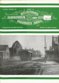
Book, Dean Filgate, "A Brief History of The Melbourne Brunswick and Coburg Tramways Trust", 1999
Book - titled "A Brief History of The Melbourne Brunswick and Coburg Tramways Trust", MBCTT, written by Bob Prentice and edited by Dean Filgate. Published by Tramway Publications 1999. Provides details on the formation of the Trust, appointments, financials, track and overhead construction, power supply, street lighting, depot and offices, opening, map, tickets, staff, operation statistics, extensions, and rolling stock. Illustrated with many photographs including a photograph of the Trust Tramways Band.Yields information about the tramways built by "The Melbourne Brunswick and Coburg Tramways Trust"Book - 24 pages including heavy card covers, titled "A Brief History of The Melbourne Brunswick and Coburg Tramways Trust", centre stapled.trams, tramways, mbctt, tramways band, coburg, construction -
 Ballarat Tramway Museum
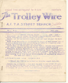
Magazine, Australian Electric Traction Association (AETA), "The Trolley Wire", Vol 1, No. 6, "The Trolley Wire", Vol 3, No. 5, Jul. 1952
Yields information about Sydney trams in the early 1950s and demonstrates means of publishing information of the era.105.1 - Spirit duplicated magazine, 8 quarto pages, single sided - " The Trolley Wire", Vol 1, No. 6, July 1952, stapled down along the left hand side. Has items on Brisbane, with map, Brisbane news, Sydney news, Gladesville to Lane Cove proposed tramway and Western Suburbs Destination Roll, 1947 - 1950. 105.2 - Spirit duplicated magazine, 9 quarto pages, single sided - " The Trolley Wire", Vol 3, No. 5, 20th May 1954, stapled down along the left hand side. Has notes on association matters, map of tramways in the Moore Park area, Drummoyne Bridge and Iron Cove tram lines, Easter workings, Sydney news. See Reg Item 5685 for other Vol 1 issues and Reg Item 5686 for Vol. 2 issues. Scan with care.Vol 3, No. 5 has pencil inscription of "H.Matthews"trams, tramways, tramway news, history, sydney, brisbane -
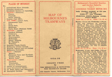 Ballarat Tramway Museum
Map, Melbourne and Metropolitan Tramways Board (MMTB), "MMTB Map of Melbourne Tramways 1934-5", 1934
Demonstrates methods of giving information to visitors to Melbourne and yields information about tram services at the time in Melbourne.Very small pocket sized timetable and map book, consisting of 2 octavo cards stapled and folded into 12 pages consisting of three pages of bus and tram round trips, 3 center pages for map of electric and cable trams, route numbers and interest points. Map printed in 4 colours. 4 pages index to routes and first and last trams to City and from City. Also gives points where suburban routes are intersected by City routes. One page devoted to places of interest. All printing in black with red headings and highlights.trams, tramways, mmtb map, mmtb, timetables, tourist trips, map