Showing 700 items
matching mt dandenong road
-
 Mt Dandenong & District Historical Society Inc.
Photograph, Mount Dandenong Primary School 1997, 1997
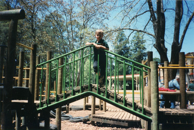
... Community Hall 42 Falls Road Mt Dandenong yarra-valley ...Miss Bell (1900 – 1984) The ‘Miss Bell Playground’ was named after Miss Rebecca Adelaide Bell, a retired teacher who regularly helped out at Mt Dandenong Primary school for 8 years. Born in NSW, Miss Bell had taught in several states and had fond memories of holidays spent at ‘Mountjoy’ in the Dandenong Ranges. When she retired Miss Bell built a home in Jeeves Avenue where she lived out the rest of her life with her Siamese cats. Miss Bell helped the children with reading, grammar spelling and history. She really cared about the children and her school visits brought her a lot of happiness. Student standing on section of play equipment in Miss Bell Playground 1997.mount dandenong, mt dandenong school, miss bell, rebecca adelaide bell, school, playground -
 Mt Dandenong & District Historical Society Inc.
Photograph, Mount Dandenong Primary School 1997, 1997
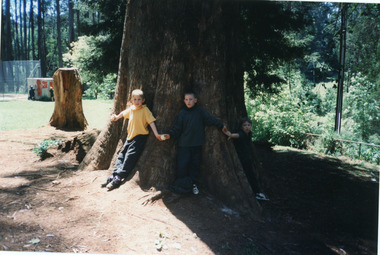
... Community Hall 42 Falls Road Mt Dandenong yarra-valley ...The first Mt Dandenong State School opened in a shed on the property of William Ferguson on the corner of Blythe and Old Coach Roads. The first teacher was Miss Ethel Gruber who opened the school on May 11th, 1897. It wasn’t until 1901 that the school shifted over the road into an old school building that was moved up to the new site from Ringwood. All the old buildings were demolished to make way for a new school that opened in 1991. There are many old, European trees that were planted in the grounds during Arbor Days. Students standing at base of large Sequoia Tree in grounds of school in 1997, centenary year.mount dandenong, mt dandenong school, sequoia, centenary, trees -
 Mt Dandenong & District Historical Society Inc.
Photograph, Mount Dandenong Primary School 1997, 1997
... Community Hall 42 Falls Road Mt Dandenong yarra-valley ...The Exersite equipment allowed for student and public use. The equipment was removed when the oval was refurbished in 2004.View of 'Exersite' equipment at bottom corner of school oval with students participating in Sports day in the background. 1997.mount dandenong, mt dandenong school, exersite -
 Mt Dandenong & District Historical Society Inc.
Photograph, Mount Dandenong Primary School 1997, 1997
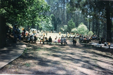
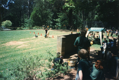
... Community Hall 42 Falls Road Mt Dandenong yarra-valley ...1997 was the school's centenary year. The first Mt Dandenong State School opened in a shed on the property of William Ferguson on the corner of Blythe and Old Coach Roads. The first teacher was Miss Ethel Gruber who opened the school on May 11th, 1897. It wasn’t until 1901 that the school shifted over the road into an old school building that was moved up to the new site from Ringwood. All the buildings were demolished to make way for a new school that opened in 1991. View of Sports Day November 1997 with parents watching and children participating.mount dandenong, mt dandenong school, centenary -
 Mt Dandenong & District Historical Society Inc.
Photograph, Mount Dandenong Primary School 1997, 1997
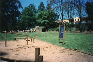
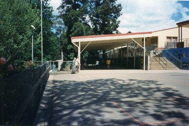
... Community Hall 42 Falls Road Mt Dandenong yarra-valley ...The first Mt Dandenong State School opened in a shed on the property of William Ferguson on the corner of Blythe and Old Coach Roads. The first teacher was Miss Ethel Gruber who opened the school on May 11th, 1897. It wasn’t until 1901 that the school shifted over the road into an old school building that was moved up to the new site from Ringwood. All the buildings were demolished to make way for a new school that opened in 1991. Looking across from asphalted area to the 'undercover area' November 1997.mount dandenong, mt dandenong school -
 Mt Dandenong & District Historical Society Inc.
Photograph, Mount Dandenong Primary School 1997, 1997
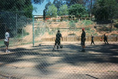
... Community Hall 42 Falls Road Mt Dandenong yarra-valley ...1997 was the Centenary Year of the school. The first Mt Dandenong State School opened in a shed on the property of William Ferguson on the corner of Blythe and Old Coach Roads. The first teacher was Miss Ethel Gruber who opened the school on May 11th, 1897. It wasn’t until 1901 that the school shifted over the road into an old school building that was moved up to the new site from Ringwood. All the buildings were demolished to make way for a new school that opened in 1991. Students playing on the basketball/tennis court below the school oval in 1997mount dandenong, mt dandenong school -
 Mt Dandenong & District Historical Society Inc.
Photograph, Mount Dandenong Primary School 1997, 1997
... Community Hall 42 Falls Road Mt Dandenong yarra-valley ...View of Sports Day looking down over the oval with the 'rebound Wall' in the foreground 1997.mount dandenong, mt dandenong school -
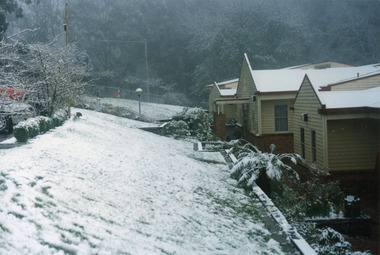
 Mt Dandenong & District Historical Society Inc.
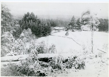
Photograph, Mt Dandenong Primary School in Snow 1995, 1995
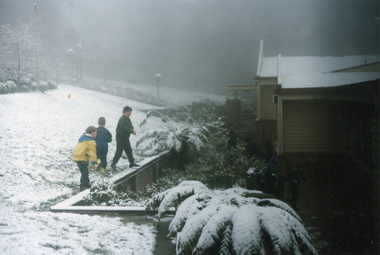
... Community Hall 42 Falls Road Mt Dandenong yarra-valley ...The first Mt Dandenong State School opened in a shed on the property of William Ferguson on the corner of Blythe and Old Coach Roads. The first teacher was Miss Ethel Gruber who opened the school on May 11th, 1897. It wasn’t until 1901 that the school shifted over the road into an old school building that was moved up to the new site from Ringwood. All the buildings were demolished to make way for a new school that opened in 1991. Up until the later 2000s snow fell at the school several times a year. Three children playing in snow at the front of Mt Dandenong Primary School 5th September 1995. The snow lasted three days.mt dandenong school, snow, mt dandenong -
 Mt Dandenong & District Historical Society Inc.
Photograph, Snow at Mt Dandenong Primary School 1995, 1995
... Community Hall 42 Falls Road Mt Dandenong yarra-valley ...Snow at Mt Dandenong Primary School 5th September 1995. Snow lasted 3 days.mt dandenong school, snow -
 Mt Dandenong & District Historical Society Inc.
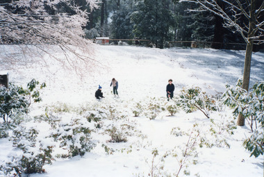
Photograph, Snow at Mt Dandenong Primary School 1995, 1995
... Community Hall 42 Falls Road Mt Dandenong yarra-valley ...Three children playing in snow covering bank and oval at Mt Dandenong Primary School 5th September 1995. Snow lasted three days.mt dandenong school, snow -
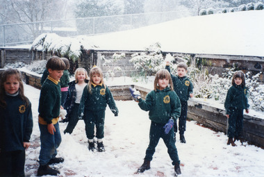 Mt Dandenong & District Historical Society Inc.
Photograph, Snow at Mt Dandenong Primary School 1995, 1995
... Community Hall 42 Falls Road Mt Dandenong yarra-valley ...Children playing in snow at the front of Mt Dandenong Primary School 5th September 1995.mt dandenong school, snow -
 Mt Dandenong & District Historical Society Inc.
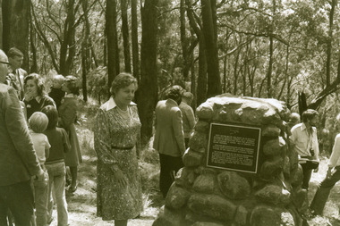
Photograph, Visitors to the site of the Kyeema Crash 1978, 1978
... Community Hall 42 Falls Road Mt Dandenong yarra-valley ...Three visitors at the cairn marking the site of the October 1938 crash of the aircraft Kyeema.air crash, kyeema, mt dandenong, cairn -
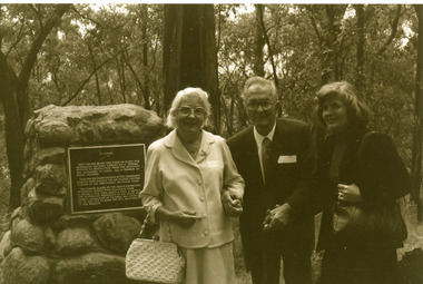
 Mt Dandenong & District Historical Society Inc.
Photograph, Cairn at Kyeema Crash Site 1988, 1988
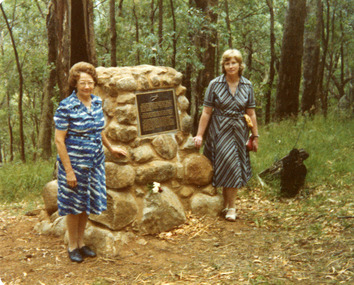
... Community Hall 42 Falls Road Mt Dandenong yarra-valley ...Visitors at the 1988 Service to commemorate 50th anniversary of the Kyeema Crash. LHS - friend of Miss Delphine Goddard, sister of passenger Gordon Goddard and RHS- Patricia Hogan from Mt Dandenong & District Historical Society.air crash, kyeema, cairn, mt dandenong -
 Mt Dandenong & District Historical Society Inc.
Photograph, Sign Indicating Kyeema Crash Site 1988, 1988
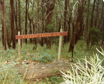
... Community Hall 42 Falls Road Mt Dandenong yarra-valley ...Simple wooden sign indicating the site of the Kyeema aircraft crash on the western slope of Mt Dandenong. The accident occurred on October 25th, 1938. All 18 onboard were killed.air crash, kyeema, mt dandenong -
 Mt Dandenong & District Historical Society Inc.
Photograph, Kyeema Crash Site Cairn 1978, 1978
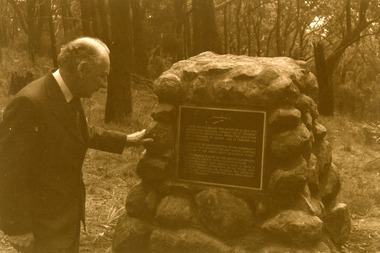
... Community Hall 42 Falls Road Mt Dandenong yarra-valley ...Macarthur Job at the cairn unveiled at the 40 year anniversary of the crash of the aircraft Kyeema (October 1938).air crash, kyeema, cairn, mt dandenong -
 Mt Dandenong & District Historical Society Inc.
Photograph, Site of Kyeema Aircraft Crash, 1978
... Community Hall 42 Falls Road Mt Dandenong yarra-valley ...Woman looking down slope towards the actual site of the Kyeema aircraft crash which occurred on October 25th, 1938. The Douglas DC-2 Kyeema, operated by Australian National Airways, was en-route from Adelaide to Melbourne when it overshot Essendon Airport by 20 miles. Descending in thick cloud, it crashed into the western face of Mt Dandenong, killing all 18 occupants.air crash, kyeema, mt dandenong -
 Mt Dandenong & District Historical Society Inc.
Photograph, Group at the Kyeema Aircraft Crash Cairn 1978, 1978
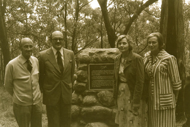
... Community Hall 42 Falls Road Mt Dandenong yarra-valley ...Family of the Hugo Gramp, who perished in the Kyeema crash, 25th October 1938, at the memorial plaque unveiled on the 40th anniversary of the disaster. L - R Mervyn Gramp, Colin Gramp, Enid Schultz, Fiona Nettlebeck. air crash, kyeema, hugo gramp, mervyn gramp, fiona nettlebeck, colin gramp, enid schultz, cairn, mt dandenong -
 Mt Dandenong & District Historical Society Inc.
Photograph, Unveiling of the Kyeema Cairn October 25, 1978, 1978
... Community Hall 42 Falls Road Mt Dandenong yarra-valley ...Mrs Sybil Gramp, daughter-in-law of passenger Hugo Gramp, unveils the cairn's memorial plaque on the accident's 40th anniversary in 1978. Sybil Gramp was also a grand-daughter of one of the other victims, Mrs Elizabeth Schrader.air crash, kyeema, sybil gramp, hugo gramp, elizabeth schrader, cairn, mt dandenong -
 Mt Dandenong & District Historical Society Inc.
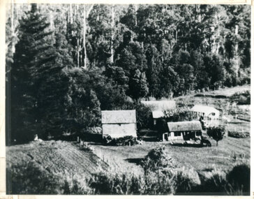
Photograph, The Settlement of Harmony Vale 1913, 1913
... Community Hall 42 Falls Road Mt Dandenong yarra-valley ...View of the settlement of Harmony Vale taken in 1913 with the guest house Kia Ora, built by George Barber in 1909, in the foreground. This photograph has a detailed inscription on the back handwritten by John Lundy-Clarke.The settlement of Harmony Vale 1913. The large home in foreground is the Guest House “Kia Ora” owned by George Barber on Lot 25 of the Village Settlement. The house above it to the left was Richardson’s house. The home of Jeanie who had left it when the picture was taken.The buildings furthest to the right of “Kia Ora” were the homestead of Isaac Jeeves of 1863 – 1871 the building furthest right with the black opening in it was the house with the tree fern floor. The flat ground above and left of Isaac’s pointed roof barn is where the creek changed its course in the 1934 flood and destroyed £4000 worth of the Rowse family’s tulip bulbs. Above the flat is Francis Matthew Child’s homestead, in the creek to the right of which can be seen the horizontal structure of the swing bridge to the sawmill of the Childs Bros which cannot be seen but in the forest to the right of the mill (bridge) can be seen a number of logs in the mill yard. The two cleared strips immediately behind Childs home were the Richardson’s original holdings and the house in the gully at the far side of the great clearing is that of the guest house “Glenrivers” belonging to W Lucas and his wife Catherine nee Child. The Richardson homestead “Harmony Vale” is behind the forest trees in the right centre. The picture gives a full view of how the settlement was cut into the centre of the great forest. george barber, kia ora, harmony vale, barber, jeanie richardson, richardson, child, matthew child, kia-ora guest house, guest house, glenrivers -
 Mt Dandenong & District Historical Society Inc.
Photograph, Jasper Road Near Erith Lane 1920, 1920
... Community Hall 42 Falls Road Mt Dandenong yarra-valley ...View of Jasper Road, near Erith Lane taken in 1920. The road is tree lined with two significant gum trees in the foreground. This photograph has a detailed inscription on the back handwritten by John Lundy-Clarke in 1974.Jasper Road near Erith Lane 1920. This road has only a narrow right of way. It was put in as a road to serve “Cherry Farm”, connecting it to the Coach Road at the Elbow in 1904. It joins a wide surveyed road running from Inverness Road to the Coach Road at the Elbow and could possibly have been surveyed by Thomas Hand at the same time as Inverness Road. The name Jasper now applies to full length between Erith Lane and Coach Road. McGivern Bros widened it in 1937 and J L Clarke removed and stored much of the rock quarried in the widening. This was later sold to Dick Moorby who sold it to the builders of St Michaels Church in Falls Road. Comment by John Lundy-Clarke 10.5.1974 jasper road, erith lane, john lundy-clarke -
 Mt Dandenong & District Historical Society Inc.
Photograph, A View Over Mountain Grange 1921, 1921
... Community Hall 42 Falls Road Mt Dandenong yarra-valley ...A view of Mountain Grange Homestead built by Thomas Hand with buildings and ground covered in snow. The photograph has historical information on the back handwritten by John Lundy-Clarke in 1976.1921 A view over “Mountain Grange” from the side of Mt Kalorama above where Grange Road is now. On the left of the homestead is the avenue of pine trees under which the annual Sunday School picnic was held. On the right is the giant pine that still stands (1976) and the great barn. The separate kitchen of the homestead can be clearly seen. mountain grange, snow, john lundy-clarke, thomas hand -
 Mt Dandenong & District Historical Society Inc.
Photograph, View From George Barber's Home On Olinda Creek Towards The Gap. c1905, 1905
... Community Hall 42 Falls Road Mt Dandenong yarra-valley ...Black and white photograph showing view towards The Gap (Jeeves Saddle), (Five Ways) taken c1905. Detailed inscription on back handwritten by John Lundy-Clarke in 1973.1905 (c ) view from Barber’s home on Olinda Creek, towards the Gap, then known as Jeeves Saddle. Barber’s stable in foreground. “Shiloah” Complex centre right. Tait’s house in gully just left of centre. Logan’s house can just be seen under magnifier at top of same gully near line of Barber’s Road. “Kalorama” just below lowest portion of Gap skyline with Barnes (Paynters) house “Iona” to its left. Photo copied 1973. JLC. george barber, shiloah, kalorama, iona, olinda creek, the gap, jeeves saddle, tait, paynter, barber -
 Mt Dandenong & District Historical Society Inc.
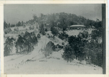
Photograph, Kalorama Gap Under Snow 1921, 1921
... Community Hall 42 Falls Road Mt Dandenong yarra-valley ...View of Kalorama Gap under snow taken in 1921. Mountjoy Guest House is at top right and Beulah Tea Rooms is in the centre. This photograph has a detailed inscription on the back handwritten by John Lundy-Clarke in 1974.Kalorama Gap under snow 1921 The leafless elm trees are low in the centre and the dual nature of the nearer one can be clearly seen, two small suckers of the older farther tree being twisted together in 1898 by Fred Jeeves. The older tree was planted 1880. Mrs Hands shop can be clearly seen, which was the Mount Dandenong North Post Office. The old Main Road runs up the centre of the picture and turns to the right and disappears behind “Mountjoy” the big guest house built by Paynters in 1905 and sold to Ellis Jeeves 1908, whose family ran it till 1943. At the bend of the road behind the big pine tree and the dark blackwood can be seen faintly the gable of Price’s house that contained the first shop on the mount. Above it is H Walker’s cottage on Ridge Road that still exists, his homestead is on the left of the picture on the same level. Below this house and to the left can be seen Ted Prices hay and corn store. The present estate agency lies between these two buildings, on the road which had recently been built. This can be seen winding from the lower left corner of picture to the left of the elms. The CRB had recently fenced the road and this is clearly seen as it circles behind trees in the left centre. Barber’s Road crosses CRB Road to the left of the dray under the leafless elm and the Coach Road dives down to the right just behind the pair of blackwoods to right of the elms. The picture was taken from just above the boundary of Isaac Jeeves’s selection Crown Allotment “C” (Jeeves Saddle) which stretched across the Gap to the other side of Mrs Hand’s shop, monopolising the gap from 1871 to 1879. Price’s house remains partly as the small house – “Mirra Laken”. kalorama gap, fiveways, post office, mountjoy, guest house, snow -
 Mt Dandenong & District Historical Society Inc.
Photograph, Isaac Jeeves First Home On Running Creek 1917, 1917
... Community Hall 42 Falls Road Mt Dandenong yarra-valley ...Enlargement of photograph taken by Norman Rowse in 1917 that shows the first home of Isaac Jeeves built at the Running (Olinda) Creek. This photograph has a detailed inscription on the back handwritten by John Lundy-Clarke in 1974.Enlargement of photo taken by Norman Rowse in 1917 of the group of buildings erected as his first home by Isaac Jeeves at the 800° contour on the Running (Olinda) Creek on Crown Allotment 925A. The small building on the right behind the pony and the fowls was Isaac’s first substantial home and was occupied in 1858 he having lived in camp on the creek as a miner since 1855. The tall building on left was barn built in the sixties and the large roof behind was the five roomed house with a tree fern floor. This last building was of blackwood entirely above the floor and was built in the early sixties. The two old homes were pulled down by the Rowses in 1918 and the tree fern floor was pulled up by Len Childs in 1933.norman rowse, isaac jeeves, len childs, running creek -
 Mt Dandenong & District Historical Society Inc.
Photograph, Post Office and 'Mountjoy', Mt. Dandenong North, 1913
... Community Hall 42 Falls Road Mt Dandenong yarra-valley ...Rose Series post card #182Copy of Rose Series postcard #182 showing Kalorama Gap in 1913. Haystacks in foreground with Mountjoy Guest House and Beulah Tea Rooms/Mt Dandenong North Post Office in centre. This photograph has a detailed inscription on the back handwritten by John Lundy-Clarke in 1974.Kalorama Gap in 1913 The elm trees are in the centre of the picture. One of these is really two as two suckers of the further tree were twisted together by Fred Jeeves in 1898 and grew as one tree. The other was planted in 1880. The shop is the shop of Mrs Eliza Hand and daughter Florence. The closed in far end of the verandah was the Mount Dandenong North Post Office. The large house is “Mountjoy” owned and run by the Jeeves Family from 1908 till 1943. It was built in 1905 by the Paynters who sold to Ellis Jeeves in 1908.He moved his line of coaches from “Kalorama” his old homestead and housed the horses in a line of stables behind “Mountjoy”. Price’s house, which contained their shop, the first one on the mountain, opened 1906, can be seen faintly behind the pine tree opposite the bend in the road, which was the main road then and now is Ridge Road. The Price’s house just shows in two tiny pieces, one on each side of the pine tree half way up. The house to the right of and high up the pine tree is Walker’s cottage which exists today opposite Jack Kidd’s home at the far edge of Lt 2 Village Settlement and was between Main Road and Barbers Road which runs down the left behind the elms. Walker’s homestead can be seen near left edge of picture 2/3 way up. The roof of the Methodist Church shows among trees left of picture. This, like Mrs Hand’s shop was built on portions separated from Isaac Jeeves’ Selection “C” known as Jeeves Saddle. kalorama gap, five ways, mountjoy, john lundy-clarke, beulah tea rooms, post office, fred jeeves, paynter, jeeves, frederick jeeves, price, walker, jack kidd -
 Mt Dandenong & District Historical Society Inc.
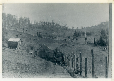
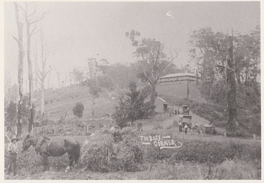
Photograph, The Busy Corner, 1907
... Community Hall 42 Falls Road Mt Dandenong yarra-valley ...View of Jeeves Saddle in 1907 showing everyday life and including important people and businesses from early settlement - Dodd's grocery and meat cutting carts; Beulah tea Rooms/Post Office; Mrs Hand, Fred Jeeves, Theo Hand.This photograph has a detailed inscription on the back handwritten by John Lundy-Clarke in 1974.“Jeeves Saddle” in 1907. Isaac Jeeves special strip of land Crown Allotment “C” 7 chains wide, lay between the sledge load of pea stalks and the far end of the verandah on Mrs Hand’s “Beulah Tea Rooms” which soon afterwards became the Mt Dandenong North Post Office. The coach road came up from the right behind the tall stump. The big woman in black was Mrs Hand. The wagon at the shop was Dodd’s grocery cart. The nearer wagon was the first coach on the mountain which had belonged to Briarty. The small cart was Dodd’s meat cutting cart. The elm trees are in the centre of the picture and above them is Price’s sign advertising their shop and newsagency. The big house is “Mountjoy” burnt 1975. Walker’s house is among the big trees left centre. Boy at horse’s head is Fred Jeeves. Boy on sledge is Theo Hand. The horse is “Blossom”. Barbers Road goes to the left from behind the elm trees.jeeves, theo hand, fred jeeves, isaac jeeves, barbers road, beulah tea rooms, post office, mount dandenong north, mt dandenong north, kalorama, coach, mountjoy -
 Mt Dandenong & District Historical Society Inc.
Photograph, 1908 View of Kalorama Gap From the Main Road, 1908
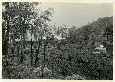
... Community Hall 42 Falls Road Mt Dandenong yarra-valley ...View of the Kalorama Gap from main Road (now Ridge Road), looking across Walker's raspberry patch with Mountjoy coaching stables on the LHS and Mountjoy Guest House in centre. Price's house and shop on the RHS.mountjoy, walker, raspberry, coach, stables -
 Mt Dandenong & District Historical Society Inc.
Photograph, 1908 View of the Kalorama Gap from Main Road With Labelling, 1908
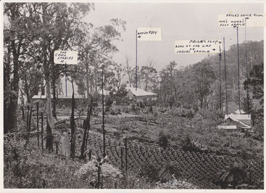
... Community Hall 42 Falls Road Mt Dandenong yarra-valley ...Photograph with labels attached to front identifying buildings. View of the Kalorama Gap from main Road (now Ridge Road), looking across Walker's raspberry patch with Mountjoy coaching stables on the LHS and Mountjoy Guest House in centre. Price's house and shop on the RHS. This photograph has a detailed inscription on the back handwritten by John Lundy-Clarke in 1974.1908 View of the Kalorama Gap from main Road – now Ridge Road above Lot 2 of the Village Settlement. Looking across Walker’s raspberry patch with “Mountjoy” coaching stables on left. “Mountjoy” in centre. Prices house and shop on right with Hands “Beulah Tearooms” above Prices roof. On hillside beyond Hand’s is the slope now taken up by Kalorama Terrace. Walker’s well, then newly dug is in lower right hand corner below the tree fern head. Mt Kalorama is the hill top right. Track leaving Main Road left is Walker’s entrance drive.kalorama, kalorama gap, walker, beulah tea rooms, price, hand, mountjoy, mt kalorama -
 Mt Dandenong & District Historical Society Inc.
Photograph, View from 'Forest Edge', 1973
... Community Hall 42 Falls Road Mt Dandenong yarra-valley ...Photograph taken in 1973 from the property 'Forest Edge', the home of early settler George Barber. This photograph has a detailed inscription on the back handwritten by John Lundy-Clarke in 1973.Taken November 1973 by JLC. View looking from “Forest Edge” George Barber’s old home towards Price’s Lot 18. Gap on right skyline. Broadways house centre on Lot 18. Lot 25 in foreground recently cleared by Merchant Builders. Kia Ora site centre left. forest edge, george barber, price, kia ora -
 Mt Dandenong & District Historical Society Inc.
Photograph, 'Callum House' - Bill Farndon's Guest House 1911, 1911
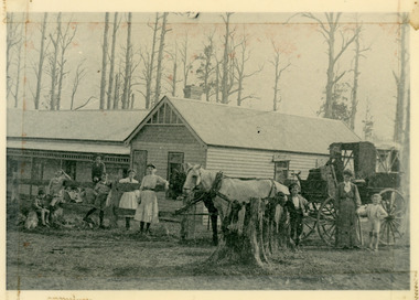
... Community Hall 42 Falls Road Mt Dandenong yarra-valley ...Front view of Callum House located on the corner of Falls and Farndons Roads. Built by Bill Farndon. In the background are trees killed by bushfires in 1897. There is a horse and buggy in the foreground. Figures standing have been identified as (from LHS) Jim Clarke, Len Farndon, Jack Clarke, Essie Farndon, Rhoda farndon, Doug Farndon, Mrs Farndon. Driver is Bill Campbell. This photograph has a detailed inscription on the back handwritten by John Lundy-Clarke in 1974.1911 “Callum House” Farndon’s guest house corner of Fall’s and Farndon’s Roads. Later “Bonvenu” and again “The Oaks”. Showing the trees killed by bushfires in 1897. Figures standing are from left – Jim Clarke, Len Farndon, Jack Clarke, Essie Farndon, Rhoda Farndon, Doug Farndon, Mrs. Farndon. Bill Campbell driving.callum house, benvenu, the oaks, essie farndon, bill farndon, rhoda farndon, bill campbell, jim clarke, jack clarke, doug farndon