Showing 855 items matching "parish plan"
-
 Ringwood and District Historical Society
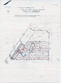
Map, Plan of Subdivision Parish of Ringwood, Victoria - c.1960
... Plan of Subdivision Parish of Ringwood, Victoria - c.1960... price. Plan of Subdivision Parish of Ringwood, Victoria - c.1960 ...Black and white photocopied plan - Part of Crown Allotments 14A and 40A showing blocks in Sharps Court and Salsibury Court, Heathmont. Some blocks showing sale price.K.J. Noonan & Co. Licensed Land Surveyors, Suite 16 "Gloucester Lodge", 445 StKilda Road, Melbourne S.C.2, Telephone BM 1631. References to coloured easements etc., not evident from b&w photocopy. -
 Ringwood and District Historical Society
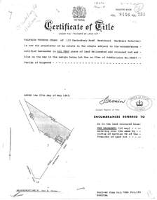
Document, Transfer of Land Act - 123 Canterbury Road, Heathmont, Victoria
Photocopied Certificate of Title Vol 8446 Fol 751 dated 27th May, 1963. Valfrids Teodors Celms of 123 Canterbury Road Heathmont, Hardware Retailer, is now the proprietor, Lot One on Plan of Subdivision No.36857, Parish of Ringwood. Page 2/3 - Transfers - Ansis Rudolf Kilevics and Mirdza Erika Kilevics, registered as joint proprietors 27th May, 1963. Mirdza Erika Kilevics registered as surviving proprietor 9th November, 1966. Velfrid Teodors Celms registered as proprietor 18th November, 1966. John Boer and Brenda Marion Boer registered as joint proprietors 11th July, 1973. Page 4/5 - Photocopy of Certificate of Title Vol 9557 Fol 423 dated 31 May, 1984 shows John Boer and Brenda Marion Boer mortgate discharged 31 October, 1984. -
 Ringwood and District Historical Society
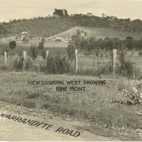
Document - Property Titles, Transfer of Land Act - "Pinemont", Ringwood, Victoria
Folder containing copies of LANDATA documents relating to "Pinemont", Panorama Avenue, Ringwood, Victoria, compiled for potential real estate sales background information purposes. Title Vol 965 Fol 923 Allotment 27B Parish of Warrandyte - James Forbes, dated 30th August, 1876. Title Vol 5236 Fol 1947157 Lots 294 and 370 on Plan of Subdivision no.11392 - Anthony Loughnan, dated 4th March, 1927. Title Vol 6415 Fol 1282937 Lot 294 on Plan of Subdivision no.11392 - Jessie McCracken Rothwell Woodard, dated 9th September, 1940. -
 City of Moorabbin Historical Society (Operating the Box Cottage Museum)
Photographs, x 4 Black & White, Whitmuir Hall / Killearnan / Bentleigh Club 1930, c1930
Whitmuir Hall was built 1850 using bricks hand -made from the clay of nearby Elster Creek. Early history of the 156 acre estate bounded by McKinnon, Centre, Thomas and Wheatley Roads is obscure. The gardens were laid out prior to 1850. Robert Gray Ford purchased 20 acres with mansion in 1872 for £ 1750 and it was valued at £ 25,000 in 1888 but sold after the Bank Crash 1890's for £ 5,000 in 1892. There were many owners over the years including Thomas Bent and in 1870 it was called 'Killearnan'. It is now is known as 'the Bentleigh Club and many original features have been restored and preserved . Whitmuir Hall, was a stately mansion built 1850 typical of the grandiose plans of successful early settlers. Stained glass Windows, furniture, imported from France and Italy have been preserved by the Bentleigh Club.4 of 13 Black & White photographs of Whitmuir Hall now Benleigh Club, Yawla St Bentleigh c 1930whitmuir hall, bentleigh club, killearnan, mansions, gold rush victoria, smith j l; smith mary ann, stanley helen, smith vic, smith harry redvers, chaff cutter, horse drawn carts, toll gates brighton, motor cars 1900, steam engines, early settlers, bentleigh, parish of moorabbin, city of moorabbin, county of bourke, moorabbin roads board, shire of moorabbin, henry dendy's special survey 1841, were j.b.; bent thomas, o'shannassy john, king richard, charman s, highett william, ormond francis, maynard -
 City of Moorabbin Historical Society (Operating the Box Cottage Museum)
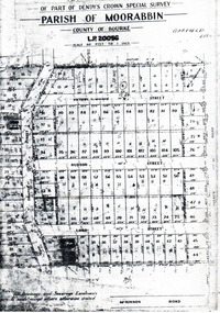
Flyer - Garfield Estate, Ormond
At the end of World War One, there was a renewed interest in residential land and a number of estates opened up in the Municipality of Moorabbin.Example of the progress of the Municipality of MoorabbinPhotocopy of the plan of the Garfield Estate, OrmondPart f Dendy's Crown Special Survey - parish of Moorabbin - County of Bourke - Garfield Estatedraper street, lord street, hudson street, blackshaw street, tucker road, ormond, mckinnon, real estate -
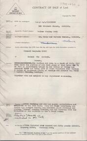
 Bendigo Historical Society Inc.
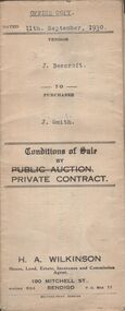
Document - H.A. & S.R. WILKINSON COLLECTION: CONTRACT OF SALE
Conditions of sale by private contract dated 11th September, 1930 between J. Beercroft (seller) and J. Smith (buyer) for pieces of land outlined in red on the plan hereon and owned and or occupied by the vendor at Epsom, being part of allotments 2, 3 and 4 section 8 in the Parish of Huntly. Price 200 pounds. Attached plan of the land sold.organization, business, h.a. & s.r wilkinson real estate -
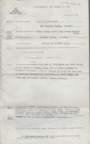
 Bendigo Historical Society Inc.
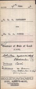
Document - H.A. & S.R. WILKINSON COLLECTION: CONDITION OF SALE
Contract of sale of land (cash) dated 9th June, 1954 between Mr. R.R. Nancarrow (seller) and Mrs M.R. Potter (buyer) for land above 50 feet below the surface and all that piece of land being part of allotment section K Parish of Sandhurst, City and County of Bendigo described in the plan at the end hereof and thereon coloured red with a frontage to Atkins Street, Bendigo. Price 1,700 pounds.organization, business, h.a. & s.r wilkinson real estate -
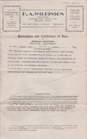
 Bendigo Historical Society Inc.
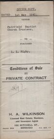
Document - H.A. & S.R. WILKINSON COLLECTION: CONDITION OF SALE
Conditions of sale by private contract dated 1st May, 1942 Fairfield Baptist Church Trustees (William Alfred Newnham, Harry Marsh, Joseph Butters Hughes, James Arthur Dobson as trustees and sellers) and L.L. Rigby (buyer) for land having a frontage of 41 feet to the west of Arthur Street by a depth of 130 feet along the north side of Duncan Street being part of lot 81 on plan of subdivision No. 568 lodged in the office of titles and being part of Crown Portion 114 Parish of Jika-Jika County of Bourke described in certificate of title volume 3540 folio 707982 together with all buildings thereon and known as 98 Arthur Street Fairfield. Price 660 pounds.organization, business, h.a. & s.r wilkinson real estate -
 Bendigo Historical Society Inc.
Document - H.A. & S.R. WILKINSON COLLECTION: CONDITION OF SALE
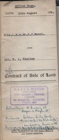
Contract of sale of land issued by H.A. Wilkinson and dated 15th August, 1952 between Mrs. L.M. & Mr. K. J. Monti (sellers) and Mr. W.J. Rielley for land being Lot 3 on plan of subdivision lodged in the office of titles in red ink No. 5062838 and being part of Crown allotment 20A section 16, City of Bendigo, Parish of Sandhurst, County of Bendigo and situate in Napoleon Crescent, White Hills, together with 6-roomed weatherboard dwelling and all sundry. Price 2,850 pounds.organization, business, h.a. & s.r wilkinson real estate -
 Bendigo Historical Society Inc.
Document - H.A. & S.R. WILKINSON COLLECTION: CONDITION OF SALE
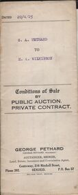
Conditions of sale by private contract dated 20th April 1925 between G. A. Pethard as seller and H. A. Wilkinson as buyer. Contract issued by George Pethard Auctioneer for sale of land situate in Elizabeth Street Nyah West being lot 100 on plan of subdivision No. 6415 lodged in the office of titles and being part of Crown Allotment 11 Parish of TynTynder West County of Tatchera described in certificate of title volume 4642 Folio 928297, together with 4-roomed weatherboard dwelling. Price 518 pounds.organization, business, h.a. & s.r wilkinson real estate -
 Bendigo Historical Society Inc.
Map - CAMPBELL COLLECTION: BENDIGO AND DISTRICT MAPS, 11-4-29
Map. Huntly, Parishes of Huntly Nerring and Neilborough. Scale 20 chains to 1 inch. Total area 4738 acres. Eaglehawk. Prepared in W.J.B. from A. and C.L. Plans by W.J.Galbraith 11-4-29. (number 396 in map cupboard 1)W.J.Galbraithmap, bendigo, agricultural lands -
Bendigo Historical Society Inc.
Map - CAMPBELL COLLECTION: BENDIGO AND DISTRICT MAPS, 16-4-29
Map. Kennington, Parishes of Sandhurst, Mandurang and Strathfieldsaye. Scale 20 chains to 1 inch. Total area 2918 acres. Prepared in W.P.B. from A. and C.L. Plans by W.J.Galbraith, 16-4-29. (number 394 in map cupboard 1)W.J.Galbraithmap, bendigo, allotments -
Bendigo Historical Society Inc.
Map - CAMPBELL COLLECTION: BENDIGO AND DISTRICT MAPS, 12-2-29
Map. Axedale, Parish of Ellesmere and Axedale, Total area 4156 acres, Prepared in W.P.B. from A. and P. Plans by W.J. Galbraith 12-2-29. (number 383 in map cupboard 1)W.J.Galbraithmap, bendigo, agricultural lands -
Bendigo Historical Society Inc.
Map - CAMPBELL COLLECTION: BENDIGO AND DISTRICT MAPS, 8-2-29
Map. Bagshot, Parishes of Wellsford, Ellesmere, and Bagshot. Huntly 4 miles, Fosterville 3 miles. Total area 5037 acres, Prepared in W.P.B. from A.C.L and D.B. Plans, by W.J.Galbraith 8-2-29. (number 382 in map cupboard 1).W.J.Galbraithmap, bendigo, agricultural lands -
Bendigo Historical Society Inc.
Map - CAMPBELL COLLECTION: BENDIGO AND DISTRICT MAPS, 30-1-29
Map. Ellesmere, Parish of Ellesmere, scale 20 chains to 1 inch. Total area 3926 acres. Prepared in W.P.B. from A. and P. Plans, by W.J. Galbraith, 30-1-29, to Bendigo along Fosterville. (number 381 in map cupboard 1)W.J.Galbraithmap, bendigo, agricultural lands -
Bendigo Historical Society Inc.
Map - CAMPBELL COLLECTION: BENDIGO AND DISTRICT MAPS, 15-2-29
Map. Nerring, Parish of Nerring, scale 20 chains to 1 inch. Prepared in W.P.B. from A. and P. Plans by W.J. Galbraith. 15-2-29. (number 379 in map cupboard 1)W.J.Galbraithmap, bendigo, agricultural lands -
Bendigo Historical Society Inc.
Map - CAMPBELL COLLECTION: BENDIGO & DISTRICT MAPS, 2-2-29
Map. Wellsford, Parishes of Wellsford and Axedale. Scale 20 chains to 1 inch. Total area 4994 acres. Prepared in W.P.B. from A. and P. Plans by W.J.G. (number 377 in map cupboard 1)W.J.Galbraithmap, bendigo, country lands -
Bendigo Historical Society Inc.
Map - CAMPBELL COLLECTION: BENDIGO & DISTRICT MAPS, 16-5-29
Map. Egerton, Parishes of Egerton and Whirrakee, scale 20 chains to 1 inch. Total area 5401 acres. Prepared in W.P.B. from A. and C.L. Plans by W.J. Galbraith (number 376 in map cupboard 1)W.J.Galbraithmap, bendigo, agricultural lands -
Bendigo Historical Society Inc.
Map - CAMPBELL COLLECTION: BENDIGO & DISTRICT MAPS, 5-4-28
Map. Sedgwick, Parishes of Strathfieldsaye, Lyell and Sedgwick. Scale 20 chains to 1 inch.Total area 5372 acres. Prepared in W.P.B. from C.l. and A. Plans by W.J. Galbraith. (number 374 in map cupboard 1)W.J.Galbraithmap, bendigo, agricultural lands -
Bendigo Historical Society Inc.
Map - CAMPBELL COLLECTION: BENDIGO AND DISTRICT MAPS, 11-4-29
Map. Huntly, Parishes of Huntly, Nerring and Neilborough. Scale 20 chains to 1 inch. Total area 4738 acres. Prepared in W.P.B. from A and C.L. Plans by W.J. Galbraith 11-4-29. Eaglehawk. IN PENCIL top right of map: Euc areas 1974 Scott & Cole Comp 5,6,7,8,9,12,13. Laurie C.Raynor 10,11,17, Part 16 South of Scotsmans Track, J.T Pierce 14,15,16 North of Scotsman Track. From Neilborough. G.Ward. A.Sloan. K.Walker at bottom of map. (number 368 in map cupboard 1)W.J.Galbraithmap, bendigo, allotments -
Bendigo Historical Society Inc.
Map - CAMPBELL COLLECTION: BENDIGO AND DISTRICT MAPS, 16-5-29
Map. Egerton, Parishes of Egerton and Whirrakee. Scale 20 chains to 1 inch. Total area 5401 acres. Prepared in W.P.B. from A. and C.L. Plans by W.J.G. 16-5-29. To Rochester 12 miles. (number 366 in map cupboard 1)W.J.G.(W.J.Galbraith)map, bendigo, allotments -
Bendigo Historical Society Inc.
Map - CAMPBELL COLLECTION: BENDIGO AND DISTRICT MAPS, 16-4-29
Map. Kennington, Parishes of Sandhurst, Mandurang and Strathfieldsaye. Scale 20 chains to 1 inch. Total area 2918 acres. Bendigo 2 1/2 miles. Prepared in W.B. from A.and C. L. Plans by W.J. Galbraith, 16-4-29. (number 364 in map cupboard 1)W.J.Galbraithmap, bendigo, allotments -
Bendigo Historical Society Inc.
Map - CAMPBELL COLLECTION: BENDIGO AND DISTRICT MAPS
Map. Ellesmere, Parish of Ellesmere. Scale 20 chains to 1 inch. Total area 3926 acres. Prepared in W.P.B. from A and P plans. (number 354 in map cupboard 1)map, bendigo, agricultural lands -
Bendigo Historical Society Inc.
Map - CAMPBELL COLLECTION: BENDIGO AND DISTRICT MAPS, 8-2-29
Map. Bagshot, Parishes of Wellsford, Ellesmere and Bagshot. Scale 20 chains to 1 inch. Total area 5037 acres. Prepared in W.P.B. from A.C.l. and D.B. Plans, W.J. Galbraith, 8-2-29 (number 353 in map cupboard 1)W.J.Galbraithmap, bendigo, agricultural lands -
Bendigo Historical Society Inc.
Map - CAMPBELL COLLECTION: BENDIGO AND DISTRICT MAPS, 12-2-29
Map. Axedale, Parishes of Ellesmere and Axedale. Scale 20 chains to 1 inch. To the west is Wellsford. Total area 4156 acres. Prepared in W.P.B. from A and P plans by W.J. Galbraith 12-2-29. (number 352 in map cupboard 1)W.J.Galbraithmap, bendigo, agricultural lands -
 Bendigo Historical Society Inc.
Document - KELLY AND ALLSOP COLLECTION: APPLICATION FOR LOAN ON MORTGAGE
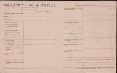
Application for Loan on Mortgage. Messrs Allsop & Co., View Point, Sandhurst. Application has space for name, occupation, amount of Loan, number of years, interest rate, Where, number of Allotment, Section, parish or County, Area, Leasehold or Freehold. Applicants opinion as to value of Land alone. Number of Acres under Cultivation. How Land is watered. State Shire Valuation, Description of Buildings and materials used, Fences, Improvements. Application for Loan on Mortgage. Messrs Allsop & Co., View Point, Sandhurst. Application has space for name, occupation, amount of Loan, number of years, interest rate. Where, number of Allotment, Section, parish or County, Area, Leasehold or Freehold. Applicants opinion as to value of Land alone. Number of Acres under Cultivation. How Land is watered, State Shire Valuation, Description of Buildings and materials used, Fences, Improvements. Is applicant in occupation of Property, if not who is, and at what Rental. Are Buildings Insured, if so, what amount. Is the Property encumbered, is so, to what amount. Present marketable value of the whole, and names and addresses of two references. Authorization to deduct from the advance the costs of the Mortgage and Charges on obtaining the Loan. Note at the end - A Government plan, or sketch showing the position of the land and written valuation from an acknowledged Valuer. On the back is space for a Valuator's Report and a note to the Valuators, also a Proposal for Loan on Mortgage with details of the loan. Date on the form is 188-.business, stockbroker, kelly & allsop, kelly and allsop collection - application for loan on mortgage, allsop & co. -
 Bendigo Historical Society Inc.
Document - H.A. & S.R. WILKINSON COLLECTION: CONTRACT OF SALE
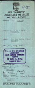
Contract of sale of real estate between Mr. R.A. Santon (vendor) and Mr. A.L. & A.K. Stringer (purchaser) dated 17th, July, 1962. Solicitor for vendor: Messrs. E.S. Cahill & Son, View Street, Bendigo. Solicitor for purchaser: Messrs Watson, James & Rogers, Bull Street, Bendigo. Property: Lot 21, Mahon Avenue, Bendigo, being lot 21 on plan of subdivision no. 31961 lodged in the office of titles parish of Sandhurst and being the whole of the land comprised in certificate of title volume 8310 folio 930 having a frontage of 53 feet to Mahon Avenue by a depth of 120 feet. Price 550 pounds.organization, business, h.a. & s.r wilkinson real estate -
 Bendigo Historical Society Inc.
Document - H. A. & S. R. WILKINSON COLLECTION: CONTRACT OF SALE
Contract of sale of land dated 11th January, 1956 between Mr. W. S. Bond (vendor) and Mr. R. B. Scott (purchaser). Property: surface and down to a depth of 50 feet below the surface of that piece of land being lot 71 on plan of subdivision lodged in the office of titles No. 16993 being part of Crown allotment 441B section H Parish of Sandhurst city of Bendigo and situate Corner Neale & Burrell Streets, Bendigo, together with brick dwelling, all sundry outbuildings, all floor coverings, all blinds, all electric light fittings and shades, Hoover washing machine, all curtains except those in the 2 front rooms and electric stovette. Price: 3,950 pounds.organization, business, h.a. & s.r wilkinson real estate -
 Bendigo Historical Society Inc.
Document - H. A. & S. R. WILKINSON COLLECTION: CONTRACT OF SALE
Contract of sale of land dated 25th August, 1956 between Mr. A. T. & Mrs. I. M. H. James (vendor) and Mr. J. H. Strange (purchaser). Property: lot 1 on plan of subdivision no. 19491 lodged in the office of titles being part of Crown allotment 24 Parish of Sandhurst County of Bendigo, land described in certificate of title volume 7646 folio 003 and situate Beischer Street, Bendigo, together with 5 roomed weatherboard dwelling, all sundry outbuildings, all floor coverings, blinds, curtains, Metro fridge, "Mettres" electric range, Hoover washing machine and all electric light fittings and shades. Price: 2,780 pounds. Attached 5 hand written notes .organization, business, h.a. & s.r wilkinson real estate -
 Bendigo Historical Society Inc.
Document - H. A. & S. R. WILKINSON COLLECTION: CONTRACT OF SALE
Conditions of sale by private contract dated 21st October, 1948 between W. L. Allen (vendor) and Mrs. H. M. Slender (purchaser). Property: all that piece of land situate in union Street, West Bendigo, being part of Crown allotment 65 section L, Parish of Sandhurst City of Bendigo and coloured red on the plan hereon, together with the right to use the land coloured blue on the said map for drainage purposes. Together with 5 room weatherboard dwelling and all sundry outbuildings. Price: 925 pounds.organization, business, h.a. & s.r wilkinson real estate