Showing 1810 items matching "planning and development"
-
 Wodonga & District Historical Society Inc
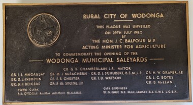
Plaque - Opening of Wodonga Municipal Saleyards 1980
This plaque commemorates the opening of the Wodonga Municipal Saleyards, named the W. G. Page Saleyards, in 1980. The last sales at this facility took place in February 2015 before being replaced by the privately-run Barnawartha North's Northern Victoria Livestock Exchange. William George Page was Shire and City Engineer in Wodonga from 1965 until 1989. When he arrived the Shire of Wodonga had a population of 17,000 people. In 1966 Wodonga was selected as a city for special growth assistance. In 1972 Bill Page presented a new Town Plan to the Wodonga Council. Over the ensuing years he dedicated himself to bring this plan to fruition. He often had to argue and campaign with the Albury-Wodonga Corporation to push for the interests of development in Wodonga. This included winning a planning appeal to allow the saleyards to be relocated to Bandiana on the outskirts of Wodonga. Bill Page retired on health grounds in July 1989. The Council honoured him with a farewell dinner and renamed the saleyards at Bandiana the W.G. Page Saleyards in his honour.The Mayor , Cr Valentina Gillard, said "Every development in Wodonga in the past 24 years has a bit of Bill Page in it". William Page died 3 months later at 58 years old.This plaque commemorates an important centre in the development and support of the livestock industry around Wodonga.A bronze plaque bearing the symbol of the Rural City of Wodonga in the upper left corner and an inscription to commemorate the opening of the Wodonga Municipal Saleyards. It includes a detailed inscription.RURAL CITY OF WODONGA / THIS PLAQUE WAS UNVEILED / ON 29TH JULY 1980 / BY /THE HON. J. C. BALFOUR M.P. / ACTING MINISTER FOR AGRICULTURE /TO COMMEMORATE THE OPENING OF THE / WODONGA MUNICIPAL SALEYARDS CR. G. R. CHAMBERLAIN, J.P. MAYOR CR. I . J. MACAULAY CR. M. J. McEACHERN CR. D. I. SCHUBERT, B'E'N', J.P CR. H. W. DRAPER, J.P. CR. D.J .IVERSON CR. E. E. CHESTER CR I. D. WATSON CR. L. C. BOYES CR. B. F. ROGERS CR. P. M. STONE. J.P CR. B. McLEAN TOWN CLERK R. I. O"TOOLE A.I.M.A., A.R.M.I.T, M.A.I.H.S CITY ENGINEER W. G. PAGE, B.E, M.I.E (AUST) B.S .E.W.S L. G. E. A saleyards wodonga, w. g. page saleyards, livestock sales wodonga -
 Port Melbourne Historical & Preservation Society
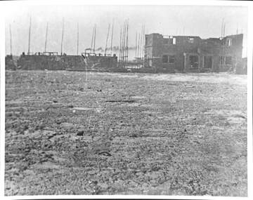
Photograph - Construction of Bank Houses, Jack GOULD
From a box of photographs in Nancy U'REN's papers used during research for her thesis, The Early Growth and Development of Sandridge (1976) and/or her book with Noel TURNBULL, A History of Port Melbourne (1983). Comparing the form and location of the doors and windows with plans for the various types of Bank Houses, the semi-detached building on the right appears to be Type 5. Jack GOULD probably created this from an earlier photograph.Black and white photograph across vacant ground to the construction of some Bank Houses.bank houses, garden city, nancy u'ren nee morris -
 Ballarat Tramway Museum
Newspaper, The Courier Ballarat, "Tram depot sale plans proceed", 17/03/1972 12:00:00 AM
Newspaper clipping from The Courier, Ballarat, dated Friday, 17/3/1972, titled "Tram depot sale plans proceed". Report on the proposals of the SEC, reported by the Manager of the Mid-Western branch of the SEC, Mr. Ivan Pellas to sell the former SEC Ballarat depot for a community housing development comprising 16 housing units, children's play and parking areas. Comments on the proposal were being sought. One of large group of newspaper cuttings from John Bainbridge, 7/4/02.ballarat tramways, depot, sale of land, housing -
 Kew Historical Society Inc
Plan - Subdivision Plan, Corsewall Estate, 1938
The Kew Historical Society collection includes almost 100 subdivision plans pertaining to suburbs of the City of Melbourne. Most of these are of Kew, Kew East or Studley Park, although a smaller number are plans of Camberwell, Deepdene, Balwyn and Hawthorn. It is believed that the majority of the plans were gifted to the Society by persons connected with the real estate firm - J. R. Mathers and McMillan, 136 Cotham Road, Kew. The Plans in the collection are rarely in pristine form, being working plans on which the agent would write notes and record lots sold and the prices of these. The subdivision plans are historically significant examples of the growth of urban Melbourne from the beginning of the 20th Century up until the 1980s. A number of the plans are double-sided and often include a photograph on the reverse. A number of the latter are by noted photographers such as J.E. Barnes.The Corsewall Estate was a subdivision, bordering on Barkers Road and Auburn Road, which created Corsewall Close. This relatively late subdivision included 29 allotments. The subdivision plan includes the dimensions of each lot as well as the width of the existing and projected roads and turning circles. The Corsewall Close Precinct is now listed on the Victorian Heritage Database (HO147) and is noted for its ‘consistent flat-type development over the entire street, which has been cleverly designed to make multi-unit dwellings appear as single buildings’.subdivision plans - hawthorn, corsewall estate -- hawthorn (vic.) -
 Bendigo Historical Society Inc.
Newspaper - CENTRAL NELL GWYNNE MINE - NEWSPAPER ARTICLE ON CENTRAL NELL GWYNNE MINE
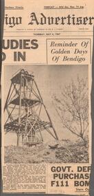
Newspaper article from the Bendigo Advertiser, dated Thursday, May 4, 1967 on the Central Nell Gwynne Mine. It has a picture of the poppet legs of the Central Nell Gwynne Mine with an old gold digger's dish in the foreground and a bush on the right. The article mentions tourists ask to see a gold mine, but none are working. The Bendigo branch of the National Trust has asked the council (who are the trustees of this once famous gold mine) whether it has any plans for the development of the site of this mine and the city engineer to make a report.newspaper, bendigo advertiser, central nell gwynne mine, central nell gwynne mine, newspaper article on central nell gwynne mine, bendigo advertiser, bendigo city council, bendigo branch of the national trust -
Port Melbourne Historical & Preservation Society
Plant specimen - Branch, Port Jackson fig tree, Holy Trinity Anglican Church, Dec 1999
The tree was chopped down December 1999 in spite of local opposition, to make way for a planned development of the church hall. The application was refused by Port Phillip Council but approved by VCAT in a contentious decision. There was conflicting advice about the health of this tree which at that time enjoyed no protection under the planning scheme. Local landscape architect, Ray PICKFORD, landscape architect and owner (at that time) of Morley's house at cnr Farrell and Nott St, was so distressed by this action that he stripped in an attempt to generate media attention. Subsequently, ward councillor Julian HILL purchased a portion of the timber from a wood recycler and it was re-made into timber benches for the refurbished Port Melbourne Library.Portion of branch from Port Jackson fig located in the grounds of the Holy Trintiy Church Hall, demolished December 1999 (Ref 1421)religion - anglican (holy trinity), built environment, demolitions -
 Melbourne Tram Museum
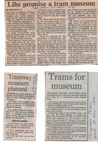
Newspaper, The Age, Progress Press, "Libs promise a tram Museum", 1991 - 1995
Set of five Newspaper cuttings and one hand written note regarding the planning for a museum at the Hawthorn Tram Museum Depot. .1 - The Age 25/11/1991 - "Libs promise a tram Museum" by Mark Brolly, quotes the Minister, Mr. Alan Brown. .2 - Progress Press, 27/11/1991 - "Trams for Museum" .3 - Progress Press, 24/3/1993 - "Tramway Museum planned" .4 - Progress Press, 27/9/1994 - "Tram museum call" .5 - Progress Press, 21/3/1995 - "Tram depot on track", features a photo of Alan Brown inside a W. Story by Emma Duncan, photo Simon .6 - Handwritten note regarding the re-development of the Hawthorn Tram depot and VicTrack details - Brendon Mack and Office of Major Projects.trams, tramways, hawthorn tram depot, tram museum, museums, minister for transport -
 Victorian Aboriginal Corporation for Languages
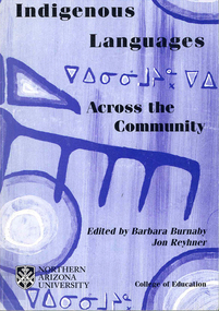
Conference proceedings, Barbara Burnaby, Indigenous languages across the community, 2002
Language - Preservation and use. Language - Social function. [Maori: New Zealand Latin]. Language planning. [Language planning in a trans-national speech community]. [The way of the drum - when earth becomes heart] [The need for an ecological cultural community] Community language management. [Methods of madness: The Tuscarora Language Committee] [Daghida: Cold Lake First Nation works towards Dene language revitalization] [The Jicarilla Apache language summer day camp] [Report on the workshop "World of Inukitut"]. Arizona. New Mexico. Oklahoma. Adult education. Women's literacy. [Teaching reading with puppets] [Assessing Lakota language teaching issues on the Cheyenne River Reservation] [Incorporating traditional Nehiyaw/Plains Cree education in the university] [Collecting texts in Crao and Portuguese for teaching] [Early vocabularies and dictionary development: A cautionary note] [The process of spelling standardization of Innu-Aimun (Montagnais)] Pidgin. Creole. [Ojibway hockey CD-ROM in the making] [The use of multimedia and the arts in language revitalization, maintenance and development: The case of the Balsas Nahuas of Guerreo, Mexico] [The languages of Indigenous Peoples in Chukotka and the media] [Meeting of the Inukitut and Yupik family of languages on May 12, 2000]B&w photographs, diagrams,international language forum, community based practice, language research, conference papers, language policy, language and whole community development, literacy development, media, educational advances, canada, united states, new zealand, zimbabwe, mexico, russia, caribbean, inui, yupik -
 Ringwood and District Historical Society
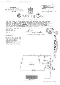
Document - Certificate of Title and Maroondah Heritage Study, "Elouera", 59 Bemboka Road, Warranwood, Victoria, previously part of Crown Section 20, Parish of Warrandyte, County of Evelyn - 4th February, 1987
Property subsequently subdivided into residential allotments with formation of Aspen Court, Warranwood, circa 2010.A4 copies of Landata Victoria documents - Vol 9725 Fol 210 derived from Vol 9701 Vol 469, and 2-page Heritage Study report.Ian Vance Lloyd and June Josephine Lloyd are joint proprietors of an estate in fee simple - Lot 4 on Plan of Subdivision no.204137B shown on the map. Subdivision includes Bemboka Road. Encumbrance E-1 later extended through Lot 4 as Aspen Court. Transfer - Proprietor June Josephine Lloyd - 29 July, 1993. Documents include 2-page Heritage report for study conducted prior to subsequent Aspen Court residential development circa 2010. -
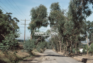
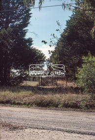
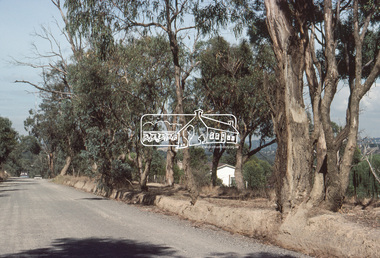
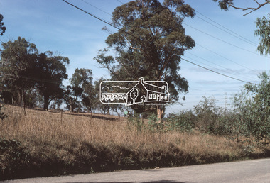
 Eltham District Historical Society Inc
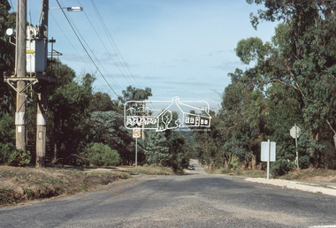
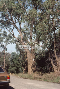
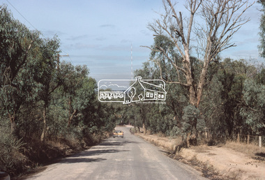
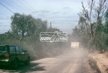
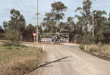
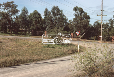
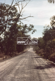
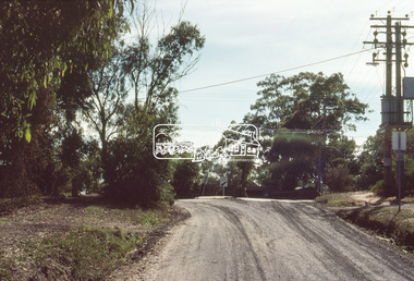
Slide, Bonds Road, Lower Plenty, Mar. 1981
One of a series of images of road infrastructure focussed on Bonds Road, Lower Plenty, the section connecting Old Eltham Road with Rosehill Road, taken by Eltham Shire Council Planning and Engineering officers. They provide perspective of the changes in housing styles and road development that began sweeping in from the mid 1970s with increasing urbanisation of what was once more outlying suburbs and regions. All images have been identified with GPS35 mm colour positive transparency (1 of 13) Mount - Kodak Kodachrome CardProcessed Mar 1981infrastructure, roads, bonds road, lower plenty, old eltham road -
 Eltham District Historical Society Inc
Slide, Bonds Road, Lower Plenty, Mar. 1981
One of a series of images of road infrastructure focussed on Bonds Road, Lower Plenty, the section connecting Old Eltham Road with Rosehill Road, taken by Eltham Shire Council Planning and Engineering officers. They provide perspective of the changes in housing styles and road development that began sweeping in from the mid 1970s with increasing urbanisation of what was once more outlying suburbs and regions. All images have been identified with GPS35 mm colour positive transparency (1 of 13) Mount - Kodak Kodachrome CardProcessed Mar 1981infrastructure, roads, bonds road, lower plenty -
 Eltham District Historical Society Inc
Slide, Bonds Road, Lower Plenty, Mar. 1981
One of a series of images of road infrastructure focussed on Bonds Road, Lower Plenty, the section connecting Old Eltham Road with Rosehill Road, taken by Eltham Shire Council Planning and Engineering officers. They provide perspective of the changes in housing styles and road development that began sweeping in from the mid 1970s with increasing urbanisation of what was once more outlying suburbs and regions. All images have been identified with GPS35 mm colour positive transparency (1 of 13) Mount - Kodak Kodachrome CardProcessed Mar 1981infrastructure, roads, bonds road, lower plenty, rosehill road -
 Eltham District Historical Society Inc
Slide, Bonds Road, Lower Plenty, Mar. 1981
One of a series of images of road infrastructure focussed on Bonds Road, Lower Plenty, the section connecting Old Eltham Road with Rosehill Road, taken by Eltham Shire Council Planning and Engineering officers. They provide perspective of the changes in housing styles and road development that began sweeping in from the mid 1970s with increasing urbanisation of what was once more outlying suburbs and regions. All images have been identified with GPS35 mm colour positive transparency (1 of 13) Mount - Kodak Kodachrome CardProcessed Mar 1981infrastructure, roads, bonds road, lower plenty -
 Eltham District Historical Society Inc
Slide, Bonds Road, Lower Plenty, Mar. 1981
One of a series of images of road infrastructure focussed on Bonds Road, Lower Plenty, the section connecting Old Eltham Road with Rosehill Road, taken by Eltham Shire Council Planning and Engineering officers. They provide perspective of the changes in housing styles and road development that began sweeping in from the mid 1970s with increasing urbanisation of what was once more outlying suburbs and regions. All images have been identified with GPS35 mm colour positive transparency (1 of 13) Mount - Kodak Kodachrome CardProcessed Mar 1981infrastructure, roads, bonds road, lower plenty, old eltham road -
 Ringwood and District Historical Society
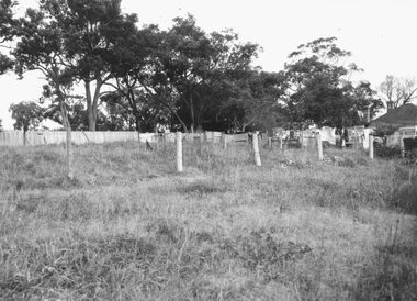
Photograph, Edwin G. Adamson A.R.P.S, Vacant land back of Adelaide St. houses, Ringwood 1963 (Eastland Litigation Photos)
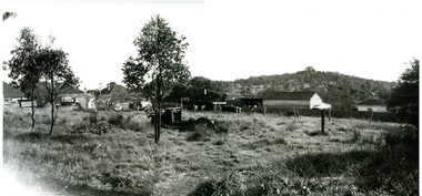
This series of SS0380 photos are part of the "Eastland Litigation" launched in 1962 by the Whitehorse Traders Co-operative Association (WTCA), against the Ringwood Council's Interim Development Order of 1960. WTCA sought "orders from the Supreme Court of Victoria that the planning scheme was invalid" - See "The Eastland Litigation" chapter in "From Horse Shoes to High Heels - Ringwood Shopping Centre and Eastland 1858-2008" by Richard Carter, Bounce Books 2009.2 photos taped to form a long horizontal photo. This taped photo was scanned in two parts and then merged using Photoshop. The two parts and the merged image are attached.Written on back of picture, 'Vacant land backs of Adelaide St. houses'. Stamped on back, 'In the Supreme Court - 13 Aug 1963' and 'Edwin G. Adamson....July 63'. -
 Ringwood and District Historical Society
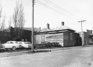
Photograph, Edwin G. Adamson A.R.P.S, Back grocery, corner Adelaide St Ringwood 1963 (Eastland Litigation Photo) (2 views), May 1963
This series of SS0380 photos are part of the "Eastland Litigation" launched in 1962 by the Whitehorse Traders Co-operative Association (WTCA), against the Ringwood Council's Interim Development Order of 1960. WTCA sought "orders from the Supreme Court of Victoria that the planning scheme was invalid" - See "The Eastland Litigation" chapter in "From Horse Shoes to High Heels - Ringwood Shopping Centre and Eastland 1858-2008" by Richard Carter, Bounce Books 2009.Written on back of photograph 2826-2, 'Back grocery, corner Adelaide St.' Stamped on back, 'Edwin G. Adamson... [and samped] In the Supreme Court 13 Aug 1963'. On back of 2826-1 (similar photo at different time): Photo of the shop and dwelling ordered to be demolished - north-eastern corner of Adelaide St and Maroondah Hwy. -
 Ringwood and District Historical Society
Photograph, Land and Post Fence - to be identified. Ringwood 1963 (Eastland Litigation Photo)
This series of SS0380 photos are part of the "Eastland Litigation" launched in 1962 by the Whitehorse Traders Co-operative Association (WTCA), against the Ringwood Council's Interim Development Order of 1960. WTCA sought "orders from the Supreme Court of Victoria that the planning scheme was invalid" - See "The Eastland Litigation" chapter in "From Horse Shoes to High Heels - Ringwood Shopping Centre and Eastland 1858-2008" by Richard Carter, Bounce Books 2009.Black and White PhotgraphStamped on back of picture, 'Edwin G. Adamson...'. And Stamped "In the Supreme Court, 13 Aug 1963 E.W.L." -
 Ringwood and District Historical Society
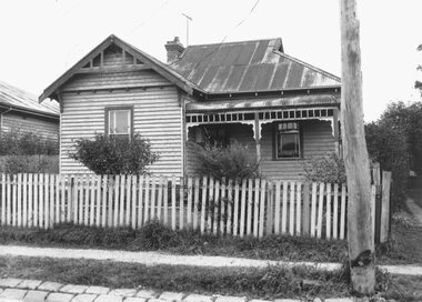
Photograph, Edwin G. Adamson A.R.P.S, House Adelaide St., Ringwood 1963 (Eastland Litigation Photo)
This series of SS0380 photos are part of the "Eastland Litigation" launched in 1962 by the Whitehorse Traders Co-operative Association (WTCA), against the Ringwood Council's Interim Development Order of 1960. WTCA sought "orders from the Supreme Court of Victoria that the planning scheme was invalid" - See "The Eastland Litigation" chapter in "From Horse Shoes to High Heels - Ringwood Shopping Centre and Eastland 1858-2008" by Richard Carter, Bounce Books 2009.Black and White PhotographWritten on back of photograph, 'House Adelaide St.' Stamped on photograph, 'Edwin G. Adamson'. Part of the Eastland Litigation series. One copy stamped "In the Supreme Court 13 Aug 1963" -
 Ringwood and District Historical Society
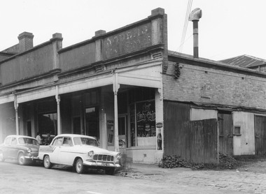
Photograph, Edwin G. Adamson A.R.P.S, Building fronting Adelaide St. Ringwood, buildings being portion of those known as 'The Block' 1963 (Eastland Litigation Photo)
This series of SS0380 photos are part of the "Eastland Litigation" launched in 1962 by the Whitehorse Traders Co-operative Association (WTCA), against the Ringwood Council's Interim Development Order of 1960. WTCA sought "orders from the Supreme Court of Victoria that the planning scheme was invalid" - See "The Eastland Litigation" chapter in "From Horse Shoes to High Heels - Ringwood Shopping Centre and Eastland 1858-2008" by Richard Carter, Bounce Books 2009.Written on back of photograph, 'Photo of the building fronting Adelaide St., buildings being portion of those known as 'The Block'. Photo showing shops on the west side of Adelaide St., near its junction with Maroondah Highway.. Fish and Chip shop" Stamped on photograph, 'In the Supreme Court 13 Aug. 1983' and 'Edwin G. Adamson...May 62'. -
 Ringwood and District Historical Society
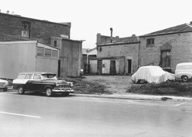
Photograph, Edwin G. Adamson A.R.P.S, Rear of buildings knows as 'The Block', Ringwood 1963 (Eastland Litigation Photo)
This series of SS0380 photos are part of the "Eastland Litigation" launched in 1962 by the Whitehorse Traders Co-operative Association (WTCA), against the Ringwood Council's Interim Development Order of 1960. WTCA sought "orders from the Supreme Court of Victoria that the planning scheme was invalid" - See "The Eastland Litigation" chapter in "From Horse Shoes to High Heels - Ringwood Shopping Centre and Eastland 1858-2008" by Richard Carter, Bounce Books 2009.Black and White PhotographWritten on back of photograph, 'Photo of the rear of buildings knows as 'The Block''. Also stamped, 'In the Supreme Court, 13 Aug. 1963' and 'Edwin G. Adamson....May 63'. -
 Ringwood and District Historical Society
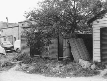
Photograph, Edwin G. Adamson A.R.P.S, Toilets in Civic Place, Ringwood, used by occupiers of 'The Block''. 1963 (Eastland Litigation Photo)
This series of SS0380 photos are part of the "Eastland Litigation" launched in 1962 by the Whitehorse Traders Co-operative Association (WTCA), against the Ringwood Council's Interim Development Order of 1960. WTCA sought "orders from the Supreme Court of Victoria that the planning scheme was invalid" - See "The Eastland Litigation" chapter in "From Horse Shoes to High Heels - Ringwood Shopping Centre and Eastland 1858-2008" by Richard Carter, Bounce Books 2009.Black and White PhotographWritten on back of photographs, 'Photo of toilets in Civic Place, used by occupiers of 'The Block''. Also stamped on photographs, 'Edwin G. Adamson...May 63' and 'In the Supreme Court, 1 Aug. 1963'. -
 Ringwood and District Historical Society
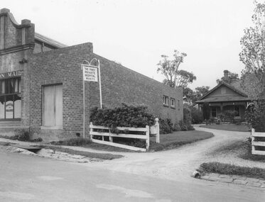
Photograph, Edwin G. Adamson A.R.P.S, Printery in Adelaide St. Ringwood intruding into the hospital grounds 1963 (Eastland Litigation Photo)
This series of SS0380 photos are part of the "Eastland Litigation" launched in 1962 by the Whitehorse Traders Co-operative Association (WTCA), against the Ringwood Council's Interim Development Order of 1960. WTCA sought "orders from the Supreme Court of Victoria that the planning scheme was invalid" - See "The Eastland Litigation" chapter in "From Horse Shoes to High Heels - Ringwood Shopping Centre and Eastland 1858-2008" by Richard Carter, Bounce Books 2009.Black and White PhotographWritten on back of photograph, 'Photo showing how the printery in Adelaide St. intrudes into the hospital grounds. See also how the printery extends back towards the hospital. Pines Hospital Adelaide St. next to "Mail" office'. Stamps on photographs read, 'Edwin G. Adamson...May 63' and 'In the Supreme Court 13 Aug. 1963'.