Showing 2301 items matching "railway line"
-
 Eltham District Historical Society Inc
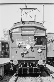
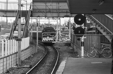
Photograph, George Coop, Tait (Red Rattler) trains at Eltham Railway Station, 7-8 February 1981, 1981
... eltham railway station, hurstbridge line, red rattler,tait... melbourne eltham railway station, hurstbridge line, red rattler,tait ...Digital TIFF file Scan of 35mm Ilford FP4 black and white transparencyeltham railway station, hurstbridge line, red rattler,tait train -
 Eltham District Historical Society Inc
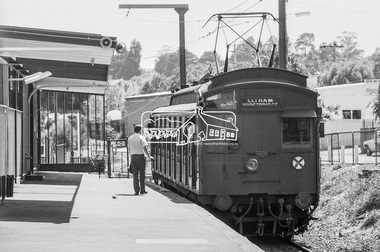
Photograph, George Coop, Single Motor Carriage (Red Rattler) Tait train at Eltham Railway Station, 7-8 February 1981, 1981
... eltham railway station, hurstbridge line, red rattler... melbourne eltham railway station, hurstbridge line, red rattler ...Digital TIFF file Scan of 35mm Ilford FP4 black and white transparencyeltham railway station, hurstbridge line, red rattler, single motor carriage, tait train -
 Eltham District Historical Society Inc
Photograph, George Coop, Single Motor Carriage (Red Rattler) Tait train departs Eltham Railway Station for Hurstbridge, c.Otober 1982, 1982
... eltham railway station, hurstbridge line, red rattler... melbourne eltham railway station, hurstbridge line, red rattler ...Digital TIFF file Scan of 35mm Ilford FP4 black and white transparencyeltham railway station, hurstbridge line, red rattler, single motor carriage, tait train -
 Eltham District Historical Society Inc
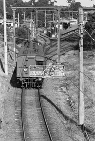
Photograph, George Coop, A Tait (Red Rattler) train departs Greensborough Railway Station bound for Princes Bridge, c. October 1982, 1982
... Greensborough Railway Station, Hurstbridge Line, Red... melbourne Greensborough Railway Station, Hurstbridge Line, Red ...Digital TIFF file Scan of 35mm Ilford FP4 black and white transparencygreensborough railway station, hurstbridge line, red rattler, tait train -
 Eltham District Historical Society Inc
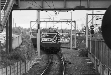
Photograph, George Coop, A Tait (Red Rattler) train arrives at Greensborough Railway Station bound for Eltham, c. October 1982, 1982
... greensborough railway station, hurstbridge line, red... melbourne greensborough railway station, hurstbridge line, red ...Digital TIFF file Scan of 35mm Ilford FP4 black and white transparencygreensborough railway station, hurstbridge line, red rattler, tait train -
 Bendigo Historical Society Inc.
Map - MARONG : COUNTY OF BENDIGO, June 1953
... Creek, Township of Marong, Bendigo Railway Line, Marong Railway... of Marong, Bendigo Railway Line, Marong Railway Station, Crusoe ...Map> Marong, County of Bendigo, Nerring, Sandhurst, Lockwood, Shelbourne, Woodstock, Leichardt, Bullock Creek, Fletcher Creek, Township of Marong, Bendigo Railway Line, Marong Railway Station, Crusoe Aqueduct. Drawn and reproduced at the Dept. of Lands and Survey, Melbourne, Victoria. June 1953. Price 2/-. By authority W.M. Houston, Government Printer. (number 74 in map cupboard 1)W.M. Houston, Government Printer.map, bendigo, marong -
 Ringwood and District Historical Society
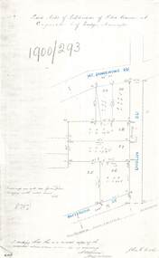
Document - Copy of Lands Department Field Notes - Subdivision of Police Reserve at Ringwood, County of Mornington, Field Notes 1900/293 - Part of O.P. R72C surveyed 1900
... , Patterson Street, Melbourne to Lilydale railway line, I certify... railway line, I certify that this is a correct copy of recorded ...Foolscap size photocopy of survey map with handwritten notations. References include Mount Dandenong Road, Dublin Road, Patterson Street, Melbourne to Lilydale railway line, I certify that this is a correct copy of recorded observations made by my assistant (signed) W. Thorn, Staff Surveyor. -
Bendigo Historical Society Inc.
Document - Digital, KEN BICE COLLECTION: NEW ARGUS MINE
... ' Railway line in foreground. This is a digital only photograph....' Railway line in foreground. This is a digital only photograph ...Copy of photo (also copy of photo): New Argus Mine, image shows poppet head right of centre, men lined up underneath. Sheds on LH side, written on boiler feeder tank 'New Argus …. Co' Railway line in foreground. This is a digital only photograph.bendigo, mining, new argus mine, bendigo, eaglehawk, new argus mine, mining -
Tatura Irrigation & Wartime Camps Museum
Photograph, 1910
... gauge railway line along which the beaching material... towards narrow gauge railway line along which the beaching ...Taken by photographer for State Rivers and Water Supply Commission.Small black and white photograph. Waranga Reservoir embankment (north end) man left of picture, looking towards narrow gauge railway line along which the beaching material is transparent from a nearby hill. Windmill left of centre and small boat and house right corner.goulburn weir, victorian state rivers and supply commission -
 Flagstaff Hill Maritime Museum and Village
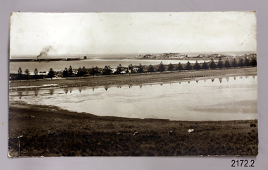
Photograph - Historical, maritime, Early 1900's
... Pertobe, railway line and cows in foreground, steam ship... Bay, Middle Island, Lake Pertobe, railway line and cows ...The photograph of Lady Bay, Warrnambool, and its surrounds reflects the historical changes to the area since since the early days of the Breakwater, from the 1870's. The foreground shows a lamppost with insulators, showing that electricity was supplied before or at the time.The subject of the photograph gives a reference point to the passage of time and the changes brought about in the growth of the town to a busy city, of the changes in transport and landscape and the management of the Bay.Photograph, sepia, showing Lady Bay, Middle Island, Lake Pertobe, railway line and cows in foreground, steam ship with smoke docked at the breakwater, small hut and larger building at start of breakwater, row of Norfolk pine trees across centre. There is a lamppost with white insulators in the foreground.flagstaff hill, warrnambool, shipwrecked-coast, flagstaff-hill, flagstaff-hill-maritime-museum, maritime-museum, shipwreck-coast, flagstaff-hill-maritime-village, photograph, warrnambool, lady bay, lake pertobe, cannon hill, middle island, steam ship, breakwater, warrnambool history, insulators, electricity, power, shed on breakwater -
 City of Moorabbin Historical Society (Operating the Box Cottage Museum)
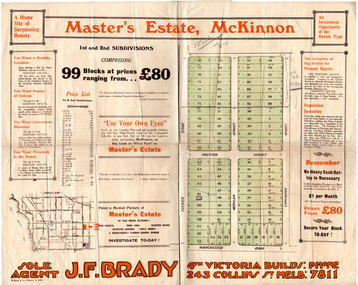
Flyer - Master's Estate, McKinnon
... of the railway line from the city to Frankston which happened in 1922.... have been just before the electrification of the railway line ...The end of WWI bought new interest in residential land. This sale must have been just before the electrification of the railway line from the city to Frankston which happened in 1922.Example of the progress of the Municipality of MoorabbinAdvertising flyer for auction of real estate sales - plan of building blocks for saleMaster's Estate, McKinnon - 99 Blocks - Agent: J. F. Bradymanchester road (now mckinnon road), tucker road, moylan street, lancaster street, preston street, real estate, bentleigh, mckinnon, moorabbin -
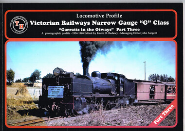 Otway Districts Historical Society
Book, Victorian Railways Narrow Gauge, Part Three, March 2001
... gauge Victorian Railways line from Colac to Crowes... outlining the narrow gauge Victorian Railways line from Colac ...The third in the historical series outlining the narrow gauge Victorian Railways line from Colac to Crowes, and then Colac to Beech Forest, in the Otways between 1954 and 1962 when the line closed. Victorian Railways Narrow Gauge "G" Class; "Garratts in the Otways" Part Three. A photographic profile - 1954-1968. Emile D. Badawy (ed.). 2001; Train Hobby Publications; Studfield (Vic). ii, 48 p.; illus. Soft cover. ISBN 1 876249 41 2colac; beech forest; crowes; victorian railways; narrow gauge; garratt; emile d. badawy; -
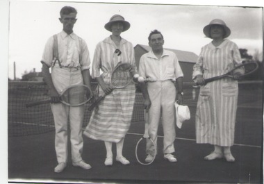 Sunbury Family History and Heritage Society Inc.
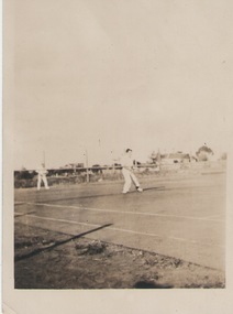
Photograph, c 1920s
... by then Sunbury Shopping Centre adjacent to the railway line.... by then Sunbury Shopping Centre adjacent to the railway line. Tennis ...The four people had gathered to play a tennis match of the courts which were sited in Evans Street, which is now occupied by then Sunbury Shopping Centre adjacent to the railway line.A black and white photograph of two ladies and two men standing in front of a net on a tennis court.tennis, tennis courts -
Bendigo Historical Society Inc.
Map - BAMAWM : COUNTY OF BENDIGO, November 1954
... , Diggorra. Elmore to Cohuna Railway Line. Township of Lockington... to Cohuna Railway Line. Township of Lockington. By authority W.M ...Map. Bamawm, County of Bendigo. Sheet 2, Pannoobamawm, Diggorra. Elmore to Cohuna Railway Line. Township of Lockington. By authority W.M. Houston, Government Printer.Drawn and reproduced at the Department of Lands and Survey, Melbourne. November 1954. Price 5/- per sheet. (number 52 in map cupboard 1)W.M. Houston, Government Printermap, bendigo, bamawm -
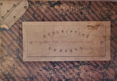 Wodonga & District Historical Society Inc
Booklet - Descriptive Surveys - Wodonga - Tallangatta Line
... the Wodonga to Tallangatta Railway line. Each survey includes... the Wodonga to Tallangatta Railway line. Each survey includes ...The first section of the Wodonga to Tallangatta line opened in 1889 and was further extended in 1891. It was a vital community link until the passenger service closed in September 1961. The last regular goods train on the line ran on 21st April 1978. These maps give detail of the surveying and building of the line.A collection of replicas of survey maps acquired to build the Wodonga to Tallangatta Railway line. Each survey includes a diagram of a portion of the line showing survey measurements and details of the land which that portion of the line will run through. It also includes the name of the landowner from whom the necessary land was acquired.The first section of the Wodonga to Tallangatta line opened in 1889 and was further extended in 1891. It was a vital community link until the passenger service closed in September 1961. The last regular goods train on the line ran on 21st April 1978. These maps give detail of the surveying and building of the line.victorian railways, wodonga to tallangatta rail service -
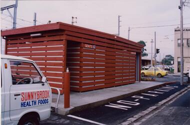 Glen Eira Historical Society
Photograph - Glenhuntly Road, Glen Huntly
... Huntly Road, north side west of the railway line. The photographs... block on Glen Huntly Road, north side west of the railway line ...Two colour photographs of a public toilet block on Glen Huntly Road, north side west of the railway line. The photographs may date to the 1980s though the exact dates are unknown. Photographer unknown.glen huntly road, glenhuntly, glenhuntly road, glen huntly, toilets, public conveniences -
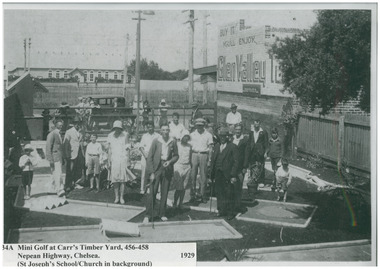 Chelsea & District Historical Society Inc
Photograph - Mini Golf, Carr's Timber Yard, 1929
... the Frankston railway line and St Joseph's School/Church.... the Frankston railway line and St Joseph's School/Church. sport ...Adults and children playing Mini Golf at Carr's Timber Yard, 456-458 Nepean Highway Chelsea. In the background you can see the Frankston railway line and St Joseph's School/Church.Black and white photo of adults and children playing mini golf at Carr's Timber Yard.sport, entertainment, mini golf, carr's timber yard, chelsea -
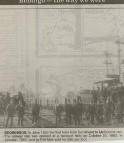 Bendigo Historical Society Inc.
Newspaper - JENNY FOLEY COLLECTION: BEGINNINGS
... ran. The railway line was opened at a banquet held on October... train from Sandhurst to Melbourne ran. The railway line ...Bendigo Advertiser ''The way we were'' from 2000. Beginnings: in June 1862 the first train from Sandhurst to Melbourne ran. The railway line was opened at a banquet held on October 20, 1862. In January 1865 land in Pall Mall sold for 90 Pounds per foot.. The clip is in a folder.newspaper, bendigo advertiser, the way we were -
 Tarnagulla History Archive
Letter: Railway League to the Mayor of Maryborough, 24th February 1873
... of railway line beyond the exisitng terminus at Dunolly so... extension of railway line beyond the exisitng terminus at Dunolly so ...David Gordon Collection. From John Simpson, Secretary of the Sandhurst, Tarnagulla and Dunolly Railway League. Asks for support of a proposed extension of railway line beyond the exisitng terminus at Dunolly so that it would continue on through Tarnagulla, Newbridge and Woodstock and terminating at Sandhurst (Bendigo), with the purpose of completing a line between Ballarat and Sandhurst (Bendigo).railways, transport, trade -
 City of Kingston
Pamphlet - Colour, Arthur Tuckett & Son, Auctioneers and Subdivisional Specialists, Auction of Station Estate, Moorabbin, 1923
... , proximity to the railway line, variety of schools and churches... facilities, proximity to the railway line, variety of schools ...Sales plan for land in the suburb of Moorabbin, bounded by Railway Crescent, South Road, Jasper Road and Pattersons Road.The developing urban area of Moorabbin within the City of Kingston. This land sale pamphlet illustrates the subdivision of land within the municipality and the changing demographic of the district as new houses are constructed.Colour pamphlet advertising an auction of the Station Estate Moorabbin. Incorporates details of the shopping facilities, proximity to the railway line, variety of schools and churches in the area, and a sales plan for home sites and shop fronts. Incorporates a map of the estate bordered by Pattersons Road, Japer Road, South Road and Railway Crescent. Handwritten in grey pencil top right front page: Station Estate / late [indecipherable] Handwritten in red pencil on subdivision map: x [on majority of properties marked on the map] Handwritten in grey pencil on subdivision map: additional subdivisions drawn in and large lines drawn across the mapmoorabbin, land sales, estate -
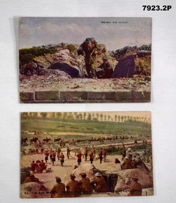 Bendigo Military Museum
Postcard - POSTCARD - PHOTOGRAPHIC WW1, Daily Mail, cWW1
... soldiers in uniform observing a military band. Railway line... soldiers in uniform observing a military band. Railway line ...Cards collected by J.P. Vercoe, No. 2530. Part of the Cooper Collection.1. Coloured postcard featuring a soldier carrying a wounded comrade out of a trench. Soldier wearing helmet in trench. Caption of photo in black type. 2. Coloured postcard featuring soldiers in uniform observing a military band. Railway line and soldiers on horseback in background. Caption of photo in black type.1. Caption in black type: "A Gallant rescue under fire. This man saved twenty lives like this." Faded handwritten letter on back. 2. Caption in black type; "Black Watch" pipers playing to the Captors of Longueval. Faded handwritten letter from “J.P. Vercoe”cooper collection, john p. vercoe, postcard, ww1, black watch -
 Orbost & District Historical Society
stamp holder and numbers, Victorian Government Railways, c. 1930s- 1980s
... Used on the Orbost-Bairnsdale railway line which closed... gippsland Used on the Orbost-Bairnsdale railway line which closed ...Used on the Orbost-Bairnsdale railway line which closed in 1987. The Bairnsdale-Orbost railway was opened in 1916 to serve the agricultural and timber industry. Because of the decline in traffic and heavy operating costs, the line was finally closed in August, 1987. Orbost Railway Station was opened on Monday 10 April 1916 as the terminus of the Orbost railway line, and closed in 1987. The station was located on the west side of the Snowy River despite the town of Orbost being on the east side of the river, in order to save on the costs of a bridge over the river, which at the time had highly variable levels This item is associated with the history of the Orbost-Bairnsdale railway line and therefore reflects the role that the rail line played in the social and economic history of Orbost.A stamp holder made of aluminium into which numbers and possibly letters can be inserted. Also a square shallow wooden box containing numbers which are used with the stamp. The numbers appear to be made of rubber.possibly V G R railway-history orbost-bairnsdale-railway -
 Ringwood and District Historical Society
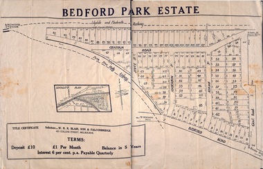
Pamphlet, Subdivisional Auction Sale, Bedford Park, Ringwood - 1924
... . The land adjoining the railway line became parkland with provision... development did not eventuate. The land adjoining the railway line ...Bedford Park subdivisional development did not eventuate. The land adjoining the railway line became parkland with provision for sporting facilities and the remainder was purchased by the Education Department as the site for Ringwood High School/Secondary College. Double sided bifolded auction sale advertisement including subdivision features and local facilitiesSubdivision plan includes Bedford Road, Graham Road, Joyce Street, Anderson Street, and Adams Street -
 Eltham District Historical Society Inc
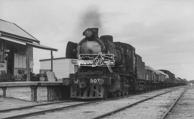
Photograph, George Coop, Steam locomotive J-507 hauling a goods train arrives at Barnes Railway Station (N.S.W.), Aug. 1963
... at Barnes Railway Station on the Victorian Railways line... at Barnes Railway Station on the Victorian Railways line ...Steam locomotive J-507 hauling a goods train arrives at Barnes Railway Station on the Victorian Railways line to Deniliquin, NSW, August 1963. Barnes is also the junction for a similar line to Balranald, NSW.Digital TIFF file Scan of black and white print Enlargement prints on textured paper (15.5 x 20.5 cm)george coop collection, j-507, j-class steam locomotive (vulcan foundry), barnes railway station -
 Ringwood and District Historical Society
Plan - Sub-division, Bedford Park Estate, Ringwood, Victoria - 1924
... . The land adjoining the railway line became parkland with provision... development did not eventuate. The land adjoining the railway line ...Bedford Park subdivisional development did not eventuate. The land adjoining the railway line became parkland with provision for sporting facilities and the remainder was purchased by the Education Department as the site for Ringwood High School/Secondary College. Poster size land sale advertisement.Subdivision plan includes Bedford Road, Graham Road, Joyce Street, Anderson Street, and Adams Street. Solicitors - W.R.R. Blair, Son & Falconbridge, 405 Collins Street, Melbourne. -
Tatura Irrigation & Wartime Camps Museum
Photograph - copy, D. Clark, Royal Visit 1954, 1989 copy
... Copy of photograph of Royal train leaving Tatura Railway... waited beside railway line to farewell the Royal couple after ...Copy of photograph of Royal train leaving Tatura Railway Station, after Royal visit 1954. Many people waited beside railway line to farewell the Royal couple after the board the Royal train.Black and white copy of photograph of Royal train, leaving Tatura 1954.on back: Royal Visit 1954royal visit -
 Bendigo Historical Society Inc.
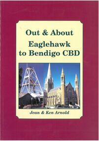
Book - Out & About Eaglehawk to Bendigo CBD
... the railway line before turning west roughly following Violet Street. ... east to Nolan Street past Lake Weroona then along the railway ...This book covers the Bendigo CBD area from Valentine street north east to Nolan Street past Lake Weroona then along the railway line before turning west roughly following Violet Street. Burgundy Outline with Cream Insert with photos of Cathedral and Central Deborah Mine. Rear Cover Canterbury Park Eaglehawk and photos of Rosalind Park - Authors Jean and Ken Arnold - 88 Pagesplaques, monuments -
 Sunbury Family History and Heritage Society Inc.
Photograph, C 1930s
... and the railway line in Sunbury. The house in the background was in Evans... and the railway line in Sunbury. The house in the background was in Evans ...The men were playing tennis on courts that were sited on railway land behind the post office between Evans Street and the railway line in Sunbury. The house in the background was in Evans Street near the post office.During the nineteenth century in Sunbury, various sporting groups such as tennis, cricket and football, were established in Sunbury.A non-digital sepia photograph with a white border of two men playing tennis. There is a house in the middle distance. The photograph is a Kodak print C592tennis, tennis courts, evans street -
 Melbourne Tram Museum
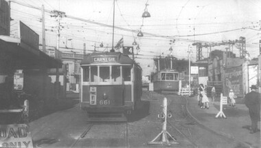
Photograph - Black and White - trams 661 and 675 Elsternwick, John Alfred, 1960
... Station, during the lowering of the railway line, 1960. Photo..., during the lowering of the railway line, 1960. Photo by John ...Black and white photograph of trams W3 661 (Route 4 Carnegie) and X2 675 (Point Ormond) , Glenhuntly Road, Elsternwick Station, during the lowering of the railway line, 1960. Photo by John Alfred. Yields information about alterations to tram services during a level crossing removal project.Photograph - Black and White - trams 661 and 675 ElsternwickHas details handwritten on rear, and John Alfred Stamp. tramways, tramcars, glenhuntly rd, level crossing, elsternwick, tram 661, tram 675, w3 class, x2 class, point ormond -
 Melbourne Tram Museum
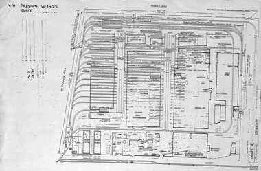
Document - Plan of Preston Workshops, The Met, c1990
... of the track over the railway line in Miller St. ... the railway line in Miller St. Yields information about Preston ...Plan shows the layout of the Preston Workshops facility during The Met era, c1990. Shows tracks, buildings and overall land dimensions. Prepared prior to the duplication of the track over the railway line in Miller St. Yields information about Preston Workshops during The Met era.Photocopy - foolscap sheet of a Plan of Preston Workshops - The Met c1990tramways, preston workshops, drawings, plans