Showing 1246 items
matching sale of land
-
 City of Moorabbin Historical Society (Operating the Box Cottage Museum)
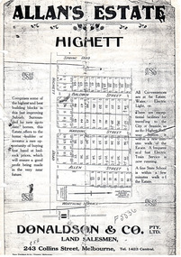
Flyer - Allan's Estate, Highett, 1922
The train line from the city to Frankston was electrified in 1922 which intensified the sale in the municipality of Moorabbin, particularly land which was in the vicinity of the railway stations.Example of the progress of the Municipality of MoorabbinPhoto copy of advertising flyer for auction of real estate sales - plan of building blocks for saleAllan's Estate, Highett land saleshighett road, baldwin street, harding street, allen street, highett, real estate, auctions -
 City of Moorabbin Historical Society (Operating the Box Cottage Museum)
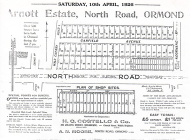
Flyer - Arnott Estate, North Road, Ormond
At the end of World War One, there was a renewed interest in residential land and a number of estates opened up in the Municipality of Moorabbin.Example of the progress of the Municipality of MoorabbinPhotocopy of Advertising flyer for auction of real estate sales - plan of building blocks for saleArnott Estate, North Road, Ormond. Auction Satire 10 April 1926 - 42 home sites & 20 shop sitesnorth road, ormond, real estate, auctions, garfield avenue -
 City of Moorabbin Historical Society (Operating the Box Cottage Museum)
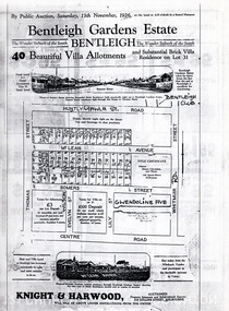
Flyer - Bentleigh Gardens Estate, Bentleigh, 1926
The train line from the city to Frankston was electrified in 1922 which intensified the sale in the municipality of Moorabbin, particularly land which was in the vicinity of the railway stations.Example of the progress of the Municipality of MoorabbinPhotocopy of advertising flyer for auction of real estate sales - plan of building blocks for saleBentleigh Gardens Estate, Bentleigh - 40 housing allotments - Auction Saturday 13 November 1926huntly road (now gawla st), mclean avenue, somers street, thomas street, bentleigh, real estate, auction -
 City of Moorabbin Historical Society (Operating the Box Cottage Museum)
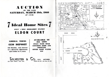
Flyer - Eldon Court, Moorabbin
In the mid 1900's land sales in Moorabbin began of the remaining market gardens which were being sub divided. Eldon Court was auctioned off in 1960Example of the progress of the Municipality of MoorabbinPhotocopy of advertising flyer for auction of real estate sales - plan of building blocks for saleEldon Court, Moorabbin - 7 Home sites - Saturday March 19 1960eldon court, moorabbin, real estate, auction -
 City of Moorabbin Historical Society (Operating the Box Cottage Museum)
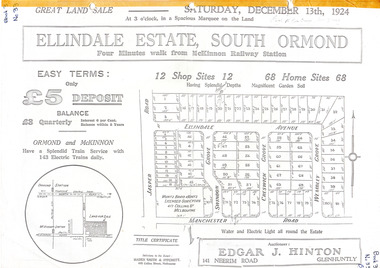
Flyer - Ellindale Estate, South Ormond, 1924
The train line from the city to Frankston was electrified in 1922 which intensified the sale in the municipality of Moorabbin, particularly land which was in the vicinity of the railway stations.Example of the progress of the Municipality of MoorabbinAdvertising flyer for auction of real estate sales - plan of building blocks for salePhotocopy of advertising brochure and two photocopies of advertisements for the auction of Ellindale Estate, South Ormond on 13 December 1924 consisting of 12 shop sites and 68 home sitesjasper road, swindon grove, creswick grove, wembley grove, ellindale ave, ormond, mckinnon, real estate, auction -
 City of Moorabbin Historical Society (Operating the Box Cottage Museum)
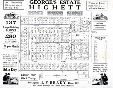
Flyer - George's Estate, Highett
At the end of World War One, there was a renewed interest in residential land and a number of estates opened up in the Municipality of Moorabbin.Example of the progress of the Municipality of MoorabbinAdvertising flyer for auction of real estate sales - plan of building blocks for saleGeorge's Estate Highett - 137 building blocksgeorge street, haynes street, dorothea street, barnett street, rose street, highett road, highett, real estate, auctions -
 City of Moorabbin Historical Society (Operating the Box Cottage Museum)
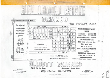
Flyer - Glen Ormond Estate, Ormond
At the end of World War One, there was a renewed interest in residential land and a number of estates opened up in the Municipality of Moorabbin.Example of the progress of the Municipality of MoorabbinPhotocopy of advertising flyer for sale of real estate sales - plan of building blocks for saleGlen Ormond Estate - For Private Sale - Home Sitesoakleigh road, ormond parade, kooringa road, leila road, huntly avenue, ormond, real estate -
 City of Moorabbin Historical Society (Operating the Box Cottage Museum)
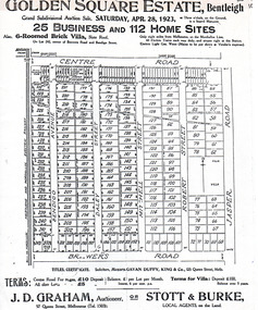
Flyer - Golden Square Estate, Bentleigh, 1923
The train line from the city to Frankston was electrified in 1922 which intensified the sale in the municipality of Moorabbin, particularly land which was in the vicinity of the railway stations.Example of the progress of the Municipality of MoorabbinAdvertising flyer for auction of real estate sales - plan of building blocks for saleGolden Square Estate, Bentleigh 25 business and 112 home sites for auction Saturday April 28 1923centre road, brewers road, jasper road, robert street, mitchell street, daley street, bendigo avenue, bentleigh, real estate, auction -
 City of Moorabbin Historical Society (Operating the Box Cottage Museum)
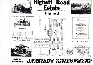
Flyer - Highett Road Estate, Highett
With the growth of Melbourne the market gardens were subdivided into building blocks as the land was worth more than the value of the crops.Example of the progress of the Municipality of MoorabbinPhotocopy of advertisement of private sale of housing lots in Highett.Highett Road Estate, Highett - 85 Magnificent Allotmentshighett road, wilson st, dalmont street, highett, real estate -
 City of Moorabbin Historical Society (Operating the Box Cottage Museum)
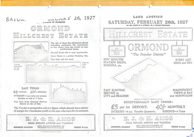
Flyer - Hillcrest Estate, Ormond, 1927
The train line from the city to Frankston was electrified in 1922 which intensified the sale in the municipality of Moorabbin, particularly land which was in the vicinity of the railway stations.Example of the progress of the Municipality of MoorabbinPhotocopy of advertising flyer for auction of real estate sales - plan of building blocks for saleHillcrest Estate, Ormond - 26 Home sites for auction Saturday 26 February 1927.parker street, holloway street, wild cherry road, wallen road, florence street, wimmera street, leila road, real estate, ormond, auction -
 City of Moorabbin Historical Society (Operating the Box Cottage Museum)
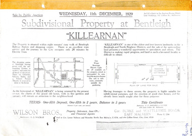
Flyer - Killearnan Estate, McKinnon, 1929
The train line from the city to Frankston was electrified in 1922 which intensified the sale in the municipality of Moorabbin, particularly land which was in the vicinity of the railway stations.Example of the progress of the Municipality of MoorabbinSubdivisional plan and advertisements for the sale of "Killearnan" Estate, Bentleigh "Killearnan" Estate, Bentleigh - Auction 11 December 1929thomas street, yawla street, huntley road, whitmuir road, mckinnon, bentleigh, real estate, auction -
 City of Moorabbin Historical Society (Operating the Box Cottage Museum)
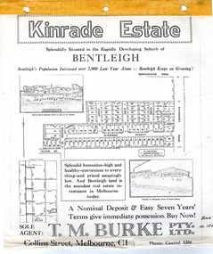
Flyer - Kinrade Estate, Bentleigh East
Kinrade Estate was not subdivided as shown in flyer. The land was purchased by Cyclone in 1950. Cyclone built a factory which manufactured wire material. This factory was closed in XXXX and a development firm purchased the land and subdivided the land into housing blocks.Example of the progress of the Municipality of MoorabbinAdvertising flyer for auction of real estate sales - plan of building blocks for saleleary avenue, charles street, peter leary, john joseph kinrade, tucker road, east boundary road, clover estate, kinrade estate, bentleigh, cyclone company, ardena court, bentleigh east -
 City of Moorabbin Historical Society (Operating the Box Cottage Museum)
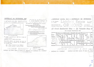
Flyer - Lichfield Estate, Ormond, 1926
The train line from the city to Frankston was electrified in 1922 which intensified the sale in the municipality of Moorabbin, particularly land which was in the vicinity of the railway stations.Example of the progress of the Municipality of MoorabbinPhotocopy of advertising flyer for auction of real estate sales - plan of building blocks for saleLichfield Estate, Ormond Auction Saturday 6 November 1926 - 46 residential sites & 24 shop siteswalnut street, collins street, north road, logan ave, ormond, real estate, auctions -
 City of Moorabbin Historical Society (Operating the Box Cottage Museum)
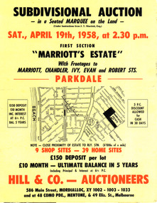
Flyer - Marriott's Estate, Parkdale, 1958
After WWII there was a decline in the market gardens in the City of Moorabbin, as the value of the land was more profitable than the crops.Example of the progress of the Municipality of MoorabbinPhotocopy of advertising flyer for auction of real estate sales - plan of building blocks for saleMarriott's Estate, Parkdale - Auction 19 April 1958 - 39 home sites - 9 shop sitesmarriott street, chandler st, ivy st, robert st, parkdale, real estate, auction -
 City of Moorabbin Historical Society (Operating the Box Cottage Museum)
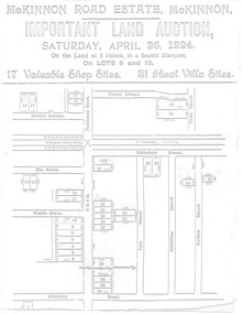
Flyer - McKinnon Road Estate, McKinnon, 1924
The train line from the city to Frankston was electrified in 1922 which intensified the sale in the municipality of Moorabbin, particularly land which was in the vicinity of the railway stations.Example of the progress of the Municipality of MoorabbinAdvertising flyer for auction of real estate sales - plan of building blocks for saleMcKinnon Road Estate, McKinnon Auction 26 April 1924 - 17 shop sites & 21 villa sitesgraham ave, prince edward ave, station street, mckinnon road, mckinnon, real estate, auctions -
 City of Moorabbin Historical Society (Operating the Box Cottage Museum)
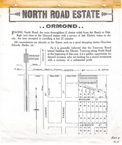
Flyer - North Road Estate, Ormond
At the end of World War One, there was a renewed interest in residential land and a number of estates opened up in the Municipality of Moorabbin.Example of the progress of the Municipality of MoorabbinAdvertising flyer for auction of real estate sales - plan of building blocks for saleNorth Road Estate, Ormond - plan of subdivision.36north road, wicklow st, leinster st, ormond, real estate -
 City of Moorabbin Historical Society (Operating the Box Cottage Museum)
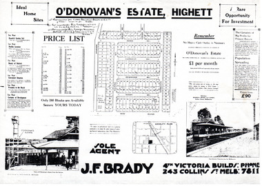
Flyer - O'Donovan's Estate, Highett
At the end of World War One, there was a renewed interest in residential land and a number of estates opened up in the Municipality of Moorabbin.Example of the progress of the Municipality of MoorabbinAdvertising flyer for auction of real estate sales - plan of building blocks for saleO'Donovan's Estate Highett - 180 blocksjames ave, clonmult ave, desmond av, mary av, bay road, cloyne street, middleton st, real estate, highett -
 City of Moorabbin Historical Society (Operating the Box Cottage Museum)
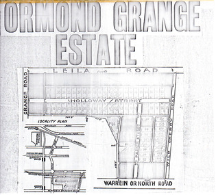
Flyer - Ormond Grange Estate, Ormond, 1913
At the end of World War One, there was a renewed interest in residential land and a number of estates opened up in the Municipality of Moorabbin.Example of the progress of the Municipality of MoorabbinPhoto copy of advertising flyer for auction of real estate sales - plan of building blocks for saleOrmond Grange Estateholloway street, wild cherry road, parker street, ormond, land sales, real estate -
 City of Moorabbin Historical Society (Operating the Box Cottage Museum)
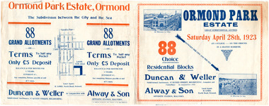
Flyer - Ormond Park Estate, Ormond, 1923
The train line from the city to Frankston was electrified in 1922 which intensified the sale in the municipality of Moorabbin, particularly land which was in the vicinity of the railway stations.Example of the progress of the Municipality of MoorabbinAdvertising flyer for auction of real estate sales - plan of building blocks for saleOrmond Park Estate, Ormond Auction Saturday 28 April 1923 - 88 residential blocks54jasper road, manchester road (now mckinnon road), hill street (now hall sreet), jasper street (now lewis street), real estate, auction, mckinnon, ormond -
 City of Moorabbin Historical Society (Operating the Box Cottage Museum)
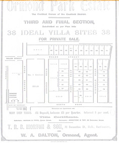
Flyer - Ormond Parke Estate, Ormond, 1913
At the end of World War One, there was a renewed interest in residential land and a number of estates opened up in the Municipality of Moorabbin.Example of the progress of the Municipality of MoorabbinPhotocopy of advertising flyer for private sale of real estate sales - plan of building blocks for saleOrmond Parke Estate, Ormond - Third and final section for private salewalsh st, ormond road, park road, nicholls road, ormond, real estate -
 City of Moorabbin Historical Society (Operating the Box Cottage Museum)
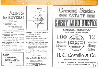
Flyer - Ormond Station Estate, Ormond, 1923
At the end of World War One, there was a renewed interest in residential land and a number of estates opened up in the Municipality of Moorabbin.Example of the progress of the Municipality of MoorabbinAdvertising flyer for auction of real estate sales - plan of building blocks for saleOrmond Station Estate, Ormond - Great Land Auction - 100 Home sites 12 shop sites - Auction Saturday 3rd February 1923malane st, foch st, coane st, beatty crescent, ormond, real estate, auction -
 City of Moorabbin Historical Society (Operating the Box Cottage Museum)
Flyer - Ozone Hill Estate, Cheltenham, 1923
The train line from the city to Frankston was electrified in 1922 which intensified the sale in the municipality of Moorabbin, particularly land which was in the vicinity of the railway stations.Example of the progress of the Municipality of MoorabbinPhotocopy of Advertising flyer for sale of real estate sales - plan of building blocks for saleOzone Hill Estate, Cheltenham 41 choice residential allotments.victor avenue, weatherall road, cheltenham, real estate, auction -
 City of Moorabbin Historical Society (Operating the Box Cottage Museum)
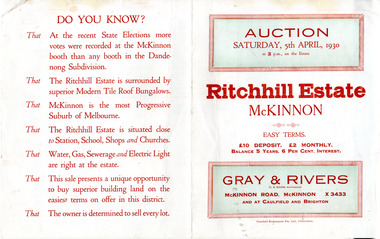
Flyer - Ritchill Estate, McKinnon, 1927
The train line from the city to Frankston was electrified in 1922 which intensified the sale in the municipality of Moorabbin, particularly land which was in the vicinity of the railway stations.Example of the progress of the Municipality of MoorabbinAdvertising flyer for auction of real estate sales - plan of building blocks for saleRitchill Estate, McKinnon, auction Saturday 5 April 1930lysbeth street, amelia st, murray road, mckinnon, auction, real estate, moorabbin -
 City of Moorabbin Historical Society (Operating the Box Cottage Museum)
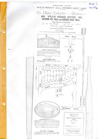
Flyer - St Elmo Estate, McKinnon / Ormond, 1927
The train line from the city to Frankston was electrified in 1922 which intensified the sale in the municipality of Moorabbin, particularly land which was in the vicinity of the railway stations.Example of the progress of the Municipality of MoorabbinThe train line from the city to Frankston was electrified in 1922 which intensified the sale in the municipality of Moorabbin, particularly land which was in the vicinity of the railway stations.St Elmo Estate, McKinnon Auction 19 February 1927 20 Villa Home Sites Superior W.B. Villa "St Elmo" and Modern Brick Villamurray road, hawthorn grove, ormond, mckinnon, real estate, auction -
 City of Moorabbin Historical Society (Operating the Box Cottage Museum)
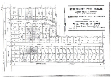
Flyer - Strathmore Park Estate, Jasper Road McKinnon, 1942
After WWII there was a decline in the market gardens in the City of Moorabbin, as the value of the land was more profitable than the crops.Example of the progress of the Municipality of MoorabbinPhotocopy of advertising flyer for auction of real estate sales - plan of building blocks for saleStrathmore Park Estate, Jasper Road Bentleigh Subdivided into 98 Ideal Allotmentsstrathmore street, wavell street, lindsay street, jasper road, mckinnon, bentleigh, real estate, auction -
 City of Moorabbin Historical Society (Operating the Box Cottage Museum)
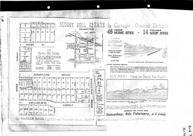
Flyer - Sunny Hill Estate, Carnegie, 1924
The train line from the city to Frankston was electrified in 1922 which intensified the sale in the municipality of Moorabbin, particularly land which was in the vicinity of the railway stations.Example of the progress of the Municipality of MoorabbinAdvertising flyer for auction of real estate sales - plan of building blocks for saleSunny Hill Estate in Carnegie - Ormond District Auction 46 Home sites - 14 Shop sites Auction 9 February 1924rigby ave, leila rd, koornanag road, grandview grove, oakleigh road, mckinnon, ormond, carnegie -
 City of Moorabbin Historical Society (Operating the Box Cottage Museum)
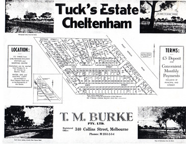
Flyer - Tuck's Estate, Cheltenham, 1940
After WWII there was a decline in the market gardens in the City of Moorabbin, as the value of the land was more profitable than the crops.Example of the progress of the Municipality of MoorabbinPhotocopy of advertising flyer for sale of real estate sales - plan of building blocks for saleTuck's Estate Cheltenham - plan of subdivisionedward street, point nepean road, eden street, tuck street, hoffman street, elman road, page street, cheltenham, real estates, auction, tuck -
 City of Moorabbin Historical Society (Operating the Box Cottage Museum)
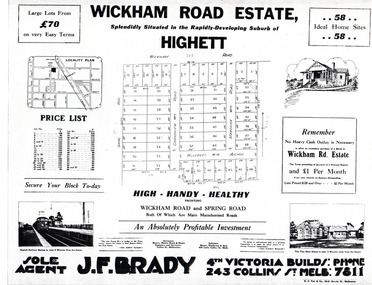
Flyer - Wickham Road Estate, Highett, 1940
After WWII there was a decline in the market gardens in the City of Moorabbin, as the value of the land was more profitable than the crops.Example of the progress of the Municipality of MoorabbinAdvertising flyer for auction of real estate sales - plan of building blocks for saleWickham Road Estate, Highett 58 Home siteshillcrest ave, wickham road, spring road, grandview road, maroona road, highett, land sales, real estate -
 Bendigo Historical Society Inc.
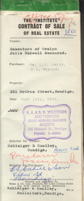
Document - H.A. & S.R. WILKINSON COLLECTION: CONTRACT OF SALE
Contract of sale of real estate dated 21st July, 1965 between Sandhurst and Northern district Trustees Executors and Agency Company Limited of View Street, Bendigo as executors of the estate of Evelyn Julie Bidwell deceased (seller) and Mr. L.B. Smith & Mr. A. Heraud (buyers). Solicitor for vendor: Schleiger & Smalley, Bendigo. Solicitor for purchaser: E.S. Cahill & Son, View Street, Bendigo. Property at No.261 McCrae Street, Bendigo being part of Crown allotment 6 section 92C being land described in certificate of title volume 4507 folio 334, together with all floor coverings, blinds, curtains and electric light fittings and shades. Price 1,300 pounds.organization, business, h.a. & s.r wilkinson real estate -
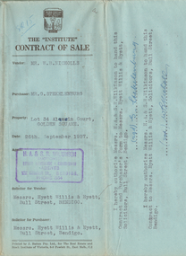 Bendigo Historical Society Inc.
Document - H.A. & S.R. WILKINSON COLLECTION: CONTRACT OF SALE
Contract of sale dated 26th September, 1957 between Mr. W.B. Nicholls (seller) and Mr. G. Stekelenburg (buyer). Solicitor for vendor: Messrs. Hyett, Willis & Hyett, Bull Street, Bendigo. Solicitor for purchaser: Messrs. Hyett, Willis & Hyett, Bull Street, Bendigo. For lot 34, Alamein Court, Golden Square being lot 34 on plan of subdivision lodged in the office of titles No. A389550 being part of Crown allotment 7 section 31A, being land described in Crown grant volume 8113 folio 731. Price 3,850 pounds.organization, business, h.a. & s.r wilkinson real estate