Showing 1306 items
matching shire of nillumbik
-
 Eltham District Historical Society Inc
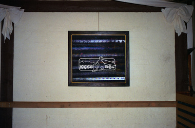
Negative - Photograph, Art show, Eltham Community Centre, c.1994
An art auction for the Save the Copper Butterfly campaign arranged by Pauline Toner was held in 1987 at which a number of which were acquired by the Shire of Eltham for the Eltham Art Collection, now part of the Nillumbik Art Collection. This show circa 1994 in the Eltham Community Centre displayed several of the works.Roll of 35mm colour negative film, 1 stripKodak Gold 100-4art exhibition, eltham community centre, eltham copper butterfly, nillumbik art collection -
 Eltham District Historical Society Inc
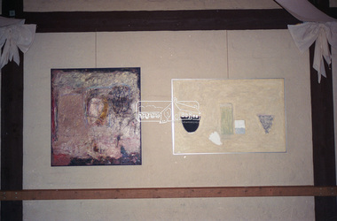
Negative - Photograph, Art show, Eltham Community Centre, c.1994
An art auction for the Save the Copper Butterfly campaign arranged by Pauline Toner was held in 1987 at which a number of which were acquired by the Shire of Eltham for the Eltham Art Collection, now part of the Nillumbik Art Collection. This show circa 1994 in the Eltham Community Centre displayed several of the works.Roll of 35mm colour negative film, 1 stripKodak Gold 100-4art exhibition, eltham community centre, eltham copper butterfly, nillumbik art collection, head in the land (private persons), doug wright -
 Eltham District Historical Society Inc
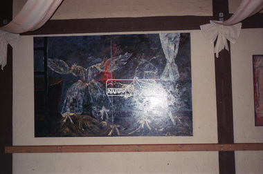
Negative - Photograph, Art show, Eltham Community Centre, c.1994
An art auction for the Save the Copper Butterfly campaign arranged by Pauline Toner was held in 1987 at which a number of which were acquired by the Shire of Eltham for the Eltham Art Collection, now part of the Nillumbik Art Collection. This show circa 1994 in the Eltham Community Centre displayed several of the works.Roll of 35mm colour negative film, 1 stripKodak Gold 100-4art exhibition, eltham community centre, eltham copper butterfly, nillumbik art collection, adriane strampp -
 Eltham District Historical Society Inc
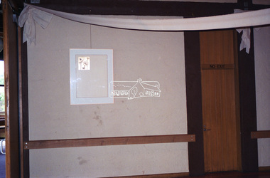
Negative - Photograph, Art show, Eltham Community Centre, c.1994
An art auction for the Save the Copper Butterfly campaign arranged by Pauline Toner was held in 1987 at which a number of which were acquired by the Shire of Eltham for the Eltham Art Collection, now part of the Nillumbik Art Collection. This show circa 1994 in the Eltham Community Centre displayed several of the works.Roll of 35mm colour negative film, 1 stripKodak Gold 100-4art exhibition, eltham community centre, eltham copper butterfly, nillumbik art collection, ona wendi henderson -
 Eltham District Historical Society Inc
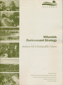
Book, Nillumbik Shire Council, Nillumbik Environment Strategy: Actions for a Sustainable Future, November 2001
... Nillumbik Shire Council... melbourne Soft cover, double stapled, 84 pages Nillumbik Environment ... -
 Eltham District Historical Society Inc
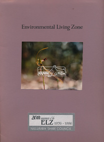
Document - Folder, Nillumbik Shire Council, Environmental Living Zone, 20th anniversary of the ELZ 1976-1996, 1996
... Nillumbik Shire Council... of the ELZ 1976-1996 Document Folder Nillumbik Shire Council ...Round the Bend Conservation Cooperative Ltd information pamphlet and information on the Environmental Living Zone of the Bend of Islands -
 Eltham District Historical Society Inc
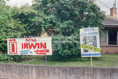
Negative - Photograph, Local government election campaigning, Lenister Ward, Nillumbik Shire Council, Eltham, Nov. 2004
... , Nillumbik Shire Council, Eltham...Nillumbik Shire Council... Helen Coleman Local Government Elections Nillumbik Shire Council ...Newly elected Lenister Ward candidate, Cr. Helen ColemanRoll of 35mm colour negative film, 7 stripsKodak GC400-8helen coleman, local government elections, nillumbik shire council, election campaign signs, eltham, lenister ward, mike irwin -
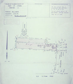
 Eltham District Historical Society Inc
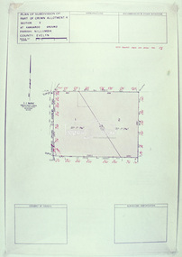
Slide - Photograph, Eltham Shire Council, Plan of Subdivision, Crown Allotment 8, Section 8A, Parish of Nillumbik,County of Evelyn, 1969
35mm colour positive transparency blue Agfacolour Service plastic mountC1, Pain, Sibbel and Carter, Research-Warrandyte Road, North Warrandyte, 4 August 1969carter, infrastructure, map, north warrandyte, pain, parish of nillumbik, plan of subdivision, planning, research-warrandyte road, sibbel, subdivison lots -
 Eltham District Historical Society Inc
Slide - Photograph, Eltham Shire Council, Plan of Subdivision of Part of Crown Allotment 4, Section 2 at Kangaroo Ground, Parish of Nillumbik, County of Evelyn, 1969
35mm colour positive transparency blue Agfacolour Service plastic mountC6, Kimse, Kangaroo Ground-St Andrews Road, 4 August 1969infrastructure, kangaroo ground, kangaroo ground-st andrews rd, kimse, map, plan of subdivision, planning, subdivison lots -
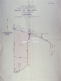
 Eltham District Historical Society Inc
Slide - Photograph, Eltham Shire Council, Plan of Subdivision, Part of Crown Portion 3, Parish of Nillumbik, County of Bourke, 1969
35mm colour positive transparency blue Agfacolour Service plastic mountC5C, Delbridge, 4 lots, Rattray Road, 4 August 1969infrastructure, map, montmorency, planning, rattray road, subdivison lots, reichelt avenue -
 Eltham District Historical Society Inc
Slide - Photograph, Eltham Shire Council, Proposed subdivision of Part of Crown Allotment 8B, Section 8A, Parish of Nillumbik, 1969
... , Parish of Nillumbik Slide Photograph Eltham Shire Council ...35mm colour positive transparency blue Agfacolour Service plastic mountE4, N0424, Stock subdivision, North Warrandyte, 4 August 1969infrastructure, map, planning, subdivison lots -
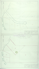
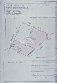
 Eltham District Historical Society Inc
Slide - Photograph, Eltham Shire Council, Plan of subdivision of Part of Crown Portion 2, Parish of Nillumbik, County of Evelyn, 1969
35mm colour positive transparency blue Agfacolour Service plastic mountC4, Warton, Panorama and Beleura, 4 August 1969infrastructure, map, planning, subdivison lots, beleura grove, old eltham road -
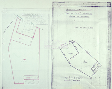
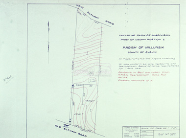 Eltham District Historical Society Inc
Slide - Photograph, Eltham Shire Council, Tentative Plan of Subdivision, Part of Crown Portion 2, Parish of Nillumbik, County of Evelyn, 1969
35mm colour positive transparency blue Agfacolour Service plastic mountB4, Fisher subdivision, Old Eltham Road and Main Road, 4 August 1969infrastructure, map, planning, subdivison lots, main road, old eltham road -
 Eltham District Historical Society Inc
Slide - Photograph, Eltham Shire Council, Tentative Plan of Subdivision, Part of Crown Allotment 20A and Part 20B, Parish of Nillumbik, County of Evelyn, 1969
35mm colour positive transparency blue Agfacolour Service plastic mountE2, N899, Young subdivision, Kangaroo Ground-Warrandyte Road, North Warrandyte, 4 August 1969infrastructure, map, planning, subdivison lots, kangaroo ground-warrandyte road, north warrandyte -
 Eltham District Historical Society Inc
Slide - Photograph, Eltham Shire Council, Plan of Subdivision, Part of Crown Allotments 5 & 6, Section 10, Parish of Nillumbik, County of Evelyn (Foster Road, Eltham East), 1969
35mm colour positive transparency blue Agfacolour Service plastic mountC5(a) DU (Vic) D/L Foster Road, Eltham East, 4 August 1969infrastructure, map, planning, subdivison lots, abersham court, ancona close, eltham east, floriston grove, foster road, frank street, gladwyn court -
 Eltham District Historical Society Inc
Slide - Photograph, Eltham Shire Council, Plan of Subdivision of Part of Crown Portion 2, Parish of Nillumbik, County of Evelyn, 1969
35mm colour positive transparency blue Agfacolour Service plastic mountC2, Grant of subdivision, Para and Glenauburn, 4 August 1969infrastructure, map, planning, subdivison lots, glenauburn road, para road -
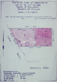 Eltham District Historical Society Inc
Slide - Photograph, Eltham Shire Council, Tentative Plan of Subdivision of Part of Lot 4 on L.P. 44 686, Parish of Nillumbik, County of Evelyn, 1969
35mm colour positive transparency blue Agfacolour Service plastic mountB3 Robinson prelim subdivision, View Road, 4 August 1969infrastructure, map, planning, subdivison lots, view road, rosehill road, lower plenty -
 Eltham District Historical Society Inc
Slide - Photograph, Eltham Shire Council, Plan of Subdivision, Part of Crown Portion 3, Parish of Nillumbik, County of Bourke, 1969
35mm colour positive transparency blue Agfacolour Service plastic mountB3 Robinson prelim subdivision, View Road, 4 August 1969infrastructure, map, planning, subdivison lots, rattray road -
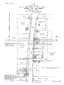 Eltham District Historical Society Inc
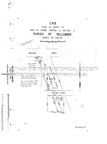
Document - Survey Plan, Country Roads Board, SP 6800, Eltham-Yarra Glen Road; Bridge St to Henry St, 1958
1958 C.R.B. Plan of Survey of Part of Crown Portions 12 and 13 Section 4 Parish of Nillumbik, County of Evelyn Eltham-Yarra Glen Road., Shire of Eltham Shows Surveyor field notes, property ownership and building type and construction.1958, a.m. gahan, a.s & s.j. davis, annie ellen davies, bridge street, country roads board, d.a. lyon, dave lyon, eltham, flora towell, g.e. gallagher, henry street, j. lyon, k. greene, main road, p.a. gahan, survey plan, w.l. chynoweth pty ltd, york street, neil webster collection -
 Eltham District Historical Society Inc
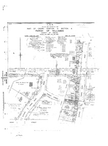
Document - Survey Plan, Country Roads Board, SP 6801, Eltham-Yarra Glen Road; Brougham St to Bridge St, 1958
1958 C.R.B. Plan of Survey of Part of Crown Portion 12 Section 4 Parish of Nillumbik, County of Evelyn Eltham-Yarra Glen Road, Shire of Eltham Shows Surveyor field notes, property ownership and building type and construction.a.j. collis, a.s. & c.g.h. fitzpatrick, board of land & works, bridge street, brougham steet, commonwealth bank of australia, country roads board, eltham, eltham rsl sub-branch, f.h. collis, f.m. smith, f.n. & e.j. burgoyne, franklin street, h.c. & r.e. burgoyne, j. jorgenson, j.f. & j.e. morris, j.n. & h.c. burgoyne, j.s. blow, john street, main road, p.e. smith, pitt street, r.j. dripps, s.j. taylor, survey plan, trustees of the eltham methodist church, 1958, eltham-yarra glen road, neil webster collection -
 Eltham District Historical Society Inc
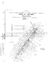
Document - Survey Plan, Country Roads Board, SP 6802, Eltham-Yarra Glen Road; Brougham St to Dalton St, 1958
1958 C.R.B. Plan of Survey of Part of Crown Portion 12 Section 4 Parish of Nillumbik, County of Evelyn Eltham-Yarra Glen Road, Shire of Eltham Shows Surveyor field notes, property ownership and building type and construction.1958, eltham-yarra glen road, a.f. munday, bible street, brougham steet, country roads board, dalton street, eltham, j.p. & e.a. sanders, j.w. & e. m. graham, l.c. skipper, l.m. jarrold, main road, napoleon street, survey plan, neil webster collection, franco and co -
 Eltham District Historical Society Inc
Document - Survey Plan, Country Roads Board, SP 6313, Eltham-Yarra Glen Road; Luck St to Henry St, 1956
1956 C.R.B. Plan of Survey of Part of Crown Portion 13 Section 4 Parish of Nillumbik, County of Evelyn Eltham-Yarra Glen Road, Shire of Eltham Shows Surveyor field notes, property ownership and building type and construction.eltham-yarra glen road, country roads board, eltham, main road, survey plan, 1956, a.l. lyon, a.w. brinkkotter, arthur street, c.r. burkett, dudley street, e.n. staff, eltham war memorial trust, henry street, luck street, pryor street, the board of land & works, the equity trustees executors and agency coy ltd, the roman catholic trusts corporation, victorian railways commision, neil webster collection -
 Eltham District Historical Society Inc
Document - Survey Plan, Country Roads Board, SP 6559-6560, Eltham-Yarra Glen Road; Elsa Ct to Luck St, 1957
1957 C.R.B. Plan of Survey of Part of Crown Portion 13 Section 4 and Crown Allotment 1 Section 1 Parish of Nillumbik, County of Evelyn Eltham-Yarra Glen Road, Shire of Eltham Shows Surveyor field notes, property ownership and building type and construction.eltham-yarra glen road, country roads board, eltham, main road, survey plan, 1957, a.m. & a.a. iowerson, a.mcg. hepburn, cecil street, coffee lounge, diamond street, e.g. murrell, elsa court, h.b. woodhead, j.c. & s.i. harding, la ronde, luck street, r.m. & v.m. white, r.n. mowatt, the board of land & works, w.g. hains, neil webster collection -
 Eltham District Historical Society Inc
Document - Survey Plan, Country Roads Board, SP 6561, Eltham-Yarra Glen Road; Park Rd to Bellevue Rd, 1957
1957 C.R.B. Plan of Survey of Parts of Crown Allotment 1 & Crown Allotment F, Section II Parish of Nillumbik, County of Evelyn Eltham-Yarra Glen Road, Shire of Eltham Shows Surveyor field notes, property ownership and building type and construction.eltham-yarra glen road, country roads board, eltham, main road, survey plan, 1957, a.r. thomas, b. & b.d. hearn, b.g. anderson, bellevue road, e.m. pitts, f.a. m. macrae, g.e. & b. moulder, j. bromley, j.m. & s.g. johnstone, k.f. pitts, l.c. docksey, m. & e.c.w. baart, m.p. bromley, n.r. ord, p.j. & g.e. murphy, park road, r.a. bruce, r.a. macbeth, r.w. shearing, railway road, s.e. & y.p. houghton, w.k. bell, w.s.r. & f.n. toley, neil webster collection -
 Eltham District Historical Society Inc
Document - Book, Execon Pty Ltd, Design Proofs, Heidelberg Artists Trail, Parks Victoria
... Nillumbik Shire Council... Manningham City Council Nillumbik Shire Council Proof Sheets Signs ...Proof sheets for the design of signs to be placed along the Heidelberg Artists Trail for Manningham, Nillumbik, Yarra Ranges and Banyule CouncilsEach proof sheet initialled and dated by Andrew Mackenzie (24.12.1998)banyule city council, heidelberg artists' trail, manningham city council, nillumbik shire council, proof sheets, signs, yarra ranges shire council -
 Eltham District Historical Society Inc
Photograph, Frank Stokes with daughters Dorothy (left) and Beryl (right) at Stokes Orchard, Nyora Road, Eltham, 1944, 1944
Frank Stokes first traveled to the district by train in 1944 to find land with the intention to establish an orchard. By chance he met Arthur Bird of Bird Orchard (bounded by Pitt Street, Eucalyptus Road and Wattle Grove) and they got talking over their common interest. Arthur put Frank up for the night and pointed out the land, part of Crown Allotment 15, Section 5, Parish of Nillumbik (CA15) somewhat diagonally opposite Bird Orchard. Frank bought the land and for the next two years would travel by train from Melbourne to Eltham every weekend establishing Stokes Orchard and building a home for his family, which they eventually moved into in 1946. In the mid 1970s the Shire of Eltham divided the orchard up into numerous rate-able parcel lots, which became affordable for Frank. As a consequence Stokes Orchard was turned into a housing development by Macquarie Builders and marketed as the Stokes Orchard Estate in two stages; Stage 1 encompassing Scarlet Ash Court, Ironbark Close and Peppermint Grove bounded by Nyora and Eucalyptus roads c.1976 and Stage 2 encompassing Stokes Place, Orchard Way, The Crest and The Lookout bound by Nyora and Diosma roads c.1979. The development of Orchard Way, The Crest and The Lookout did not proceed as planned due to the lack of the sewer along Diosma Road and so many of the proposed lots were incorporated into five-acre parcels instead.Representative of the orchard growing areas of ElthamDigital file only - Digitised by EDHS from a scrapbook (containing commercially printed photos of digital scans) on loan from Beryl Bradbury (nee Stokes), daughter of Frank Stokes.1944, beryl bradbury (nee stokes), beryl bradbury (nee stokes) collection, dorothy stokes, eltham, frank stokes, nyora road, stokes orchard -
 Eltham District Historical Society Inc
Photograph, Frank Stokes with his mother Florence (nee West) and children, Dorothy (left), David (centre) and Beryl (right), Stokes Orchard, Nyora Road, Eltham, c.1950, 1950c
Frank's mother Florence was visiting from England at the time. Frank Stokes first traveled to the district by train in 1944 to find land with the intention to establish an orchard. By chance he met Arthur Bird of Bird Orchard (bounded by Pitt Street, Eucalyptus Road and Wattle Grove) and they got talking over their common interest. Arthur put Frank up for the night and pointed out the land, part of Crown Allotment 15, Section 5, Parish of Nillumbik (CA15) somewhat diagonally opposite Bird Orchard. Frank bought the land and for the next two years would travel by train from Melbourne to Eltham every weekend establishing Stokes Orchard and building a home for his family, which they eventually moved into in 1946. In the mid 1970s the Shire of Eltham divided the orchard up into numerous rate-able parcel lots, which became affordable for Frank. As a consequence Stokes Orchard was turned into a housing development by Macquarie Builders and marketed as the Stokes Orchard Estate in two stages; Stage 1 encompassing Scarlet Ash Court, Ironbark Close and Peppermint Grove bounded by Nyora and Eucalyptus roads c.1976 and Stage 2 encompassing Stokes Place, Orchard Way, The Crest and The Lookout bound by Nyora and Diosma roads c.1979. The development of Orchard Way, The Crest and The Lookout did not proceed as planned due to the lack of the sewer along Diosma Road and so many of the proposed lots were incorporated into five-acre parcels instead.Representative of the orchard growing areas of ElthamDigital file only - Digitised by EDHS from a scrapbook (containing commercially printed photos of digital scans) on loan from Beryl Bradbury (nee Stokes), daughter of Frank Stokes.1950, beryl bradbury (nee stokes), beryl bradbury (nee stokes) collection, david stokes, dorothy stokes, eltham, flatbed truck, florence stokes (nee west), frank stokes, nyora road, stokes orchard -
 Eltham District Historical Society Inc
Photograph, Stokes family, Nyora Road, Eltham, c.1952, 1952c
Taken from outside the family home on the southest corner of the intersection of Nyora Road and Pitt Street with Eucalyptus Road, looking northeast across the Stokes Orchard L-R: David, Howard, Beryl (kneeling), Dorothy and Gladys Stokes with Gladys's mother sitting in Gladys's father's car with Spot the dog, Nyora Road, Eltham, c.1952 Frank Stokes first traveled to the district by train in 1944 to find land with the intention to establish an orchard. By chance he met Arthur Bird of Bird Orchard (bounded by Pitt Street, Eucalyptus Road and Wattle Grove) and they got talking over their common interest. Arthur put Frank up for the night and pointed out the land, part of Crown Allotment 15, Section 5, Parish of Nillumbik (CA15) somewhat diagonally opposite Bird Orchard. Frank bought the land and for the next two years would travel by train from Melbourne to Eltham every weekend establishing Stokes Orchard and building a home for his family, which they eventually moved into in 1946. In the mid 1970s the Shire of Eltham divided the orchard up into numerous rate-able parcel lots, which became affordable for Frank. As a consequence Stokes Orchard was turned into a housing development by Macquarie Builders and marketed as the Stokes Orchard Estate in two stages; Stage 1 encompassing Scarlet Ash Court, Ironbark Close and Peppermint Grove bounded by Nyora and Eucalyptus roads c.1976 and Stage 2 encompassing Stokes Place, Orchard Way, The Crest and The Lookout bound by Nyora and Diosma roads c.1979. The development of Orchard Way, The Crest and The Lookout did not proceed as planned due to the lack of the sewer along Diosma Road and so many of the proposed lots were incorporated into five-acre parcels instead.Representative of the orchard growing areas of ElthamDigital file only - Digitised by EDHS from a scrapbook (containing commercially printed photos of digital scans) on loan from Beryl Bradbury (nee Stokes), daughter of Frank Stokes.1948-1951 vauxhall velox, 1948-1951 vauxhall wyvern, 1952, beryl bradbury (nee stokes), beryl bradbury (nee stokes) collection, david stokes, dorothy stokes, eltham, gladys stokes, nyora road, spot (dog), stokes orchard -
 Eltham District Historical Society Inc
Photograph, Stokes family with horse and sled, Nyora Road, Eltham, c.1950, 1950c
Taken from outside the family home on the southest corner of the intersection of Nyora Road and Pitt Street with Eucalyptus Road, looking northeast across the Stokes Orchard Frank Stokes with children, Dorothy (left), Beryl and David Frank Stokes first traveled to the district by train in 1944 to find land with the intention to establish an orchard. By chance he met Arthur Bird of Bird Orchard (bounded by Pitt Street, Eucalyptus Road and Wattle Grove) and they got talking over their common interest. Arthur put Frank up for the night and pointed out the land, part of Crown Allotment 15, Section 5, Parish of Nillumbik (CA15) somewhat diagonally opposite Bird Orchard. Frank bought the land and for the next two years would travel by train from Melbourne to Eltham every weekend establishing Stokes Orchard and building a home for his family, which they eventually moved into in 1946. In the mid 1970s the Shire of Eltham divided the orchard up into numerous rate-able parcel lots, which became affordable for Frank. As a consequence Stokes Orchard was turned into a housing development by Macquarie Builders and marketed as the Stokes Orchard Estate in two stages; Stage 1 encompassing Scarlet Ash Court, Ironbark Close and Peppermint Grove bounded by Nyora and Eucalyptus roads c.1976 and Stage 2 encompassing Stokes Place, Orchard Way, The Crest and The Lookout bound by Nyora and Diosma roads c.1979. The development of Orchard Way, The Crest and The Lookout did not proceed as planned due to the lack of the sewer along Diosma Road and so many of the proposed lots were incorporated into five-acre parcels instead.Representative of the orchard growing areas of ElthamDigital file only - Digitised by EDHS from a scrapbook (containing commercially printed photos of digital scans) on loan from Beryl Bradbury (nee Stokes), daughter of Frank Stokes.1950, beryl bradbury (nee stokes), beryl bradbury (nee stokes) collection, david stokes, dorothy stokes, eltham, frank stokes, horse, nyora road, sled, stokes orchard -
 Eltham District Historical Society Inc
Photograph, The Stokes family home blanketed with snow, corner Nyora and Eucalyptus roads, Eltham, winter 1951, 1951
Taken from outside the family home on the southest corner of the intersection of Nyora Road and Pitt Street with Eucalyptus Road. Frank Stokes first traveled to the district by train in 1944 to find land with the intention to establish an orchard. By chance he met Arthur Bird of Bird Orchard (bounded by Pitt Street, Eucalyptus Road and Wattle Grove) and they got talking over their common interest. Arthur put Frank up for the night and pointed out the land, part of Crown Allotment 15, Section 5, Parish of Nillumbik (CA15) somewhat diagonally opposite Bird Orchard. Frank bought the land and for the next two years would travel by train from Melbourne to Eltham every weekend establishing Stokes Orchard and building a home for his family, which they eventually moved into in 1946. In the mid 1970s the Shire of Eltham divided the orchard up into numerous rate-able parcel lots, which became affordable for Frank. As a consequence Stokes Orchard was turned into a housing development by Macquarie Builders and marketed as the Stokes Orchard Estate in two stages; Stage 1 encompassing Scarlet Ash Court, Ironbark Close and Peppermint Grove bounded by Nyora and Eucalyptus roads c.1976 and Stage 2 encompassing Stokes Place, Orchard Way, The Crest and The Lookout bound by Nyora and Diosma roads c.1979. The development of Orchard Way, The Crest and The Lookout did not proceed as planned due to the lack of the sewer along Diosma Road and so many of the proposed lots were incorporated into five-acre parcels instead.Representative of the orchard growing areas of Eltham. One of the rare times it has snowed in ElthamDigital file only - Digitised by EDHS from a scrapbook (containing commercially printed photos of digital scans) on loan from Beryl Bradbury (nee Stokes), daughter of Frank Stokes.1951, beryl bradbury (nee stokes) collection, eltham, eucalyptus road, nyora road, snow, stokes family home