Showing 10764 items
matching site
-
 Queen Victoria Women's Centre
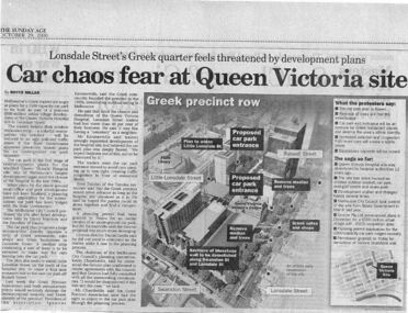
Newspaper excerpt, The Sunday Age, Car Chaos fear at Queen Victoria Site: Lonsdale Street's Greek quarter feels threatened by development plans, 29 October 2000
Newspaper excerpt from The Sunday Age. Page 5 and a smaller introduction probably from the front page. Smaller excerpt colour photo of blue-stone and cast-iron wall which was to be demolished. Larger excerpt, a black and white aerial view of QVWC and the block where it is situated. building construction, building permits, historic building -
 Queen Victoria Women's Centre
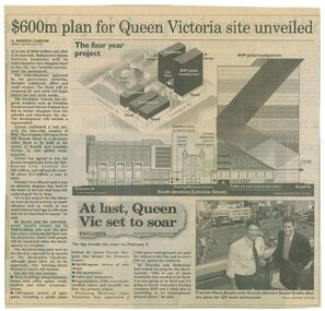
Newspaper clipping, Wayne Taylor, $600m plan for Queen Victoria site unveiled, 21 February 2001
Unveiling of the QV plans by Groconnewspaper clipping from The Age. Graphic representing the works to be done on the QV block between Swanston street and Russell street. Black and white photo at the bottom of page of Premier Steve Bracks with director of Grocon, Daniel Grollo after the plans for QV were announced. building construction, historic building, civic centres, town planning -
 Queen Victoria Women's Centre
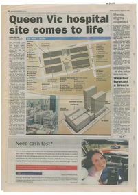
Newspaper excerpt, Queen Vic hospital site comes to life, 24 August 2003
newspaper articles Sunday Herald Sun page 28. colour photograph of the construction works bottom left of article's images. Graphic images of the the construction works and what would be included in the centre.town planning, historic building, retail trade, restaurants, construction and demolition workers -
 Stawell Historical Society Inc
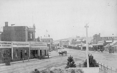
Photograph, Main Street Stawell looking East from the Present War Memorial site 1878
Main St. looking East towards Big Hill from Coffee Palace Verandah over Present War Memorial area. 1878 Businesses from left Walters and Son Factory, General Furnishing Mart, Stawell Town Hall, J. & A. Price Wine Spirits & Provision Merchants, Stawell Post Office. On right south side of Main Street, two-storey wooden Bull & Mouth Hotel, Whiteside Taylors, Carters Boot shop, Lecky Draper, C. Mulcahy Post Office Hotel, G.J. Hewlett Baker & Confectionery, Iron Monger, Victoria House Bond Draper, Town Hall Hotel, J. Richards Fancy Repository. Victorian Views. C. Herbert, Photo. Stawell 1878stawell business streetscape -
 Stawell Historical Society Inc
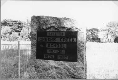
Photograph, Greens Creek School Number 1381 -- Plaque at the Old School site
School - Greens Creek No. 1381 Plaquestawell education -
 Surrey Hills Historical Society Collection
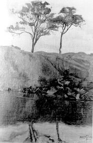
Photograph, Muriel Pornitz (deceased), Quarry on site of Grovedale Road - James Street Park
The photo is of a painting of the dam formed on land between Grovedale Road and James Street, Surrey Hills. It was painted in 1927 by Miss Muriel Pornitz, an art teacher, who lived in Grovedale Road. The land had been part of Mr James Maling Snr’s property and in the 1880s clay was removed to build houses, including his own located on the corner of Weybridge and James Streets. Maling grazed cattle on this area and used it as a dam. The land was subsequently made into parkland, the quarry / dam having been filled in after several drownings had occurred in the 1920s/1930s. See also SHP94, another copy of the same. Muriel Hedwig Lucy Pornitz lived at 22 Grovedale Road, Surrey Hills. She was born c1894 in Balwyn; died in Kew on 1 December 1982. She was the daughter of Konrad Pornitz (1864-1903) and his wife Charlotte Richardson Gooderidge (1863-1942), known as Tottie, who married in 1890. Konrad Pornitz is listed in the 1892 directory as living in Edgevale Road, Kew and the business Pornitz and Ross at 291 & 293 Little Collins Street, importers and commission merchants. The 1896 directory gives the Kew address as 176 Edgevale Road, Kew, however the business Pornitz and Ross was dissolved on 1st day of October 1892, by mutual agreement. Legal notice advised that: Mr Pornitz will hereafter carry on the business on his own behalf at the same address, under the style "Pornitz and Ross". Muriel is buried in Box Hill Cemetery (B-086-0042) along with Ulrich Horst Holm Pornitz known as Horst or Bon (d 1957) and Edith Olga Pornitz (d 1951), her brother and sister. A further sibling (Konrad b 1891) died in infancy. He is buried with his mother in Boroondara (Kew) Cemetery - C/E A 0366. Konrad died at his home 'Yarran' in Lane Cove Road, North Sydney on 31 October 1903; reported in the Sydney Morning Herald. Buried Gore Hill Cemetery, St Leonards, North Sydney. The headstone reveals he was born in Chemnitz, Saxony in 1863. Muriel was also known as Muriel Pornett. She studied at the South Australian School of Arts & Crafts in 1911 under James Ashton and Fred Britton, and at the Australian School of Etching in Sydney. She was also an illustrator and cartoonist. The photo, and the painting from which it is derived, documents the landscape prior to close settlement and is material to early building and farming in the Surrey Hills area.A black and white photograph of a painting of a landscape of parkland. Two trees are on top of a rise and are reflected at the bottom in water. The signature of the artist is in the bottom right corner: "AUST MP 192" (and the rest is cut off).(miss) muriel pornitz, grovedale road, james street, surrey hills, artists, parks and reserves, (mr) john butler maling, snr, quarry, dam, (miss) muriel hedwig lucy pornitz, box hill cemetery, muriel pornett -
 Surrey Hills Historical Society Collection
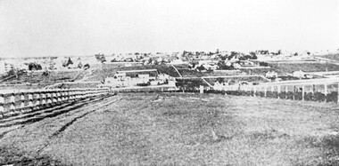
Photograph, Looking towards Box Hill from the site of the Surrey Hills Golf Club, 1902, 1902
Reproduced by permission of Mr John Arnold from his book: "The Riversdale Golf Club - a history, 1892-1977." Copyright to book: Riversdale Golf Club. Surrey Hills Golf Club operated from 1892-1908 then moved and became Riversdale Golf Club. The game was played across paddocks from Trafalgar Street, Mont Albert to Whitehorse Road and down Victoria Crescent to where Box Hill TAFE is now located in Elgar Road. There were problems with cows eating the tee flags! The clubhouse still exists as 30 Trafalgar Street.Black and white photo with a large grassy paddock in the foreground. From the bottom left and right post-and-rail fences converge on a group of large industrial buildings in the centre middle distance. In the background are paddocks and buildings."Top: Looking towards Box Hill from the links in 1902. The old Box Hill Gas Works is in the centre of the picture."sports grounds, surrey hills golf club, riversdale golf club, box hill gas works, gasworks, public utilities, gas -
 Round the Bend Conservation Co-operative
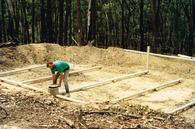
A member building a transpiration bed to recycle the household water. This is a way of concentrating absorption trenches in a confined area, managing waste water and containing the soil disturbance to the site
-
![Watercolour on paper, [Camp site with washing] by Neville Bunning](/media/collectors/530576742162ef0fa09a2288/items/534748159821f420f8c03702/item-media/58185564d0cdd12fd0913d4a/item-fit-380x285.jpg) Federation University Art Collection
Federation University Art CollectionWatercolour on paper, [Camp site with washing] by Neville Bunning
Neville Mirvane BUNNING (1902-1990) During World War Two he served with the RAAF. He was an Art Teacher at the Ballarat School of Mines from 05 February 1946 to 22 September 1964. Neville Bunning formed the Ballarat Artist's Society (later the Ballarat Society of Artists), a group that sponsored art and which invited modernist artists to speak to students and to the public of Ballarat. He also wrote a weekly column in the Ballarat Courier. Bunning produced a bust of Australian Prime Minister, The Right Honourable J.A. Lyons from Tasmania, who died in office. Bunning died in Subiaco, Western Australia on 29 April 1990. This item is part of the Federation University Art Collection. The Art Collection features over 1000 works and was listed as a 'Ballarat Treasure' in 2007.Framed watercolour and pencil on paperLR Neville M Bunning signature in pencilart, artwork, neville bunning, campsite, camping, washing, available, holiday, ballarat technical art school staffmember -
 University of Melbourne, Burnley Campus Archives
Plan, M. Drake et al, Site Location Plan of Incubator Building and Random Sample Laying Test for Burnley Gardens, 1967
Plan by Public Works Dept., Melbourne. M. Drake (draughtsman), R. G. Wilson, Chief Architect.m. drake, g.r. wilson -
 University of Melbourne, Burnley Campus Archives
Plan, Proposed Site for Plant Science Laboratory and Glasshouse Block, 1964
Plan on tracing paper.laboratory, glasshouse -
University of Melbourne, Burnley Campus Archives
Plan, A. Lucy, Burnley Gardens Site Works, 1958
Plan showing layout of Gardens bound by Swan St and the Yarra Boulevard. Buildings shown include Fernery, Silo, Residence, Glasshouses, Manure Bins, Store, Milking Sheds, Admin. Building, Laying Sheds, Breeder Shed, Chicken Run, Potting Shed and Plant Research Lab. Also showing proposed paths and kerbing. Public Works Dept., Chief Engineer's Dept. drawn by A. Lucy. Scale 1 in:40 ftgardens, sheds, glasshouses, buildings, a. lucy -
 University of Melbourne, Burnley Campus Archives
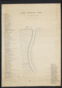
Plan, Burnley Horticultural School. Site for Experimental Plots, 1930
Pencilled notes: Planted 1930 (according to Mr. Fish). Revised 1932, 1937. Still in existence 20-9-50 A.J.T[eese] Plan with Swan St on N side and curved metal road from N to S. Details of plants on either side numbered with position marked on plan. Scale 1 inch to 20 feet. Sealed in plastic cover. Used for Centenary display. On reverse side: "Entrance & Garden Outlay"burnley horticultural school, experimental plots -
 University of Melbourne, Burnley Campus Archives
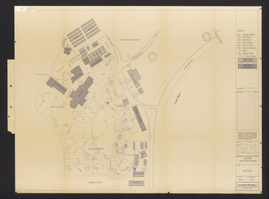
Plan, Burnley Horticultural College: Site Plan, 1983-1984
Plans of the Burnley Campus, Ornamental Gardens from Plan 11.0715 by Alexander Metherell Pty. Ltd. Dated November 1983. Scale 1:500. (1) 5 copies, buildings shaded showing construction type. Job No BHC/1 Drawing No SP/1. Tree placements stamped on, includes legend. (2) 2 copies No SP/1c. In Description column, "A" Building Names 7/02/1984. Also see B15.0352 full report. B11.0715 originals. B11.0599 SP/3.ornamental gardens, burnley campus, burnley horticultural college, alexander metherell p/l -
 University of Melbourne, Burnley Campus Archives
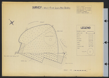
Plan, Survey: Site 1 - Front Lawn, Main Building, 1985
Plan of Front Lawn area with legend. V.C.A.H - Burnley Horticultural Engineering Surveying Exercise dated 10.09.1985. Group Members: T. Allworth, M. Appleby, B Barker (Student: Mary Appleby). Scale 1:100.vcah, lawns -
University of Melbourne, Burnley Campus Archives
Plan, C. van Zwel, A Blind Lady's Dream - Site Analysis, 1983
Proposed garden for Mrs C van Zwol of 99 St Clem's Road East Doncaster 3109. Microclimates, Influences and Services by Jacinta Bartlet.t Drawing No 3/8 dated October 1983. Includes 7 colour photographs.jacinta bartlett, east doncaster, microclimates -
University of Melbourne, Burnley Campus Archives
Plan, Alexander Metherell Pty. Ltd, Report on Existing Site Conditions at Victorian College of Agriculture and Horticulture Burnley, 1983
Report in plastic folder by Alexander Metherell Pty. Ltd., Melbourne dated November, 1983. Includes plans of Orchard and Campus. See B11.0716 and B11.0599 for descriptions of plans.alexander metherell, vcah, burnley -
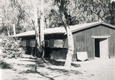 Wonga Park Community Cottage History Group
Photograph (sub-item) - Black and White, Rowallan Hall, 1984, built for the Scouts by voluntary labour on Yarra Brae, the site of both Pan-Pacific Jamborees in 1948 and 1955, and of the 1961 World Rover Moot. Now the Scout movement owns this hall and surrounding land
-
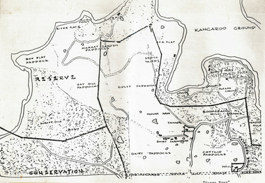 Wonga Park Community Cottage History Group
Plan (sub-item) - Black and White, Map of “Yarra Brae”, site of Scout Jamboree and World Rover Moot
-
 Wonga Park Community Cottage History Group
Photograph (sub-item) - Black and White, On the road to Wonga Park, Mr. J.E. Hooper’s house and orchard, 1931, as seen from Jumping Creek Road, now the site of Hooper’s Road
-
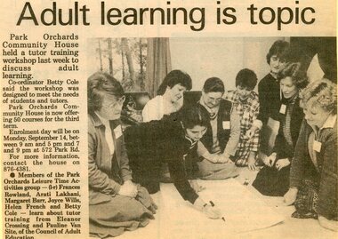 Park Orchards Community House
Photograph, Adult learning classes at the Park Orchards Community House, with tutors Eleanor Crossing and Pauline Van Site. Circa 1985
Unknown year -
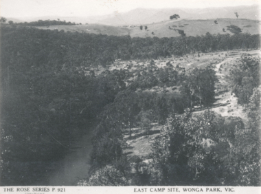 Wonga Park Community Cottage History Group
Photograph (sub-item) - Black and White, View over the East Camp site at Wonga Park for Pan-Pacific Scout Jamboree in 1948-9
-
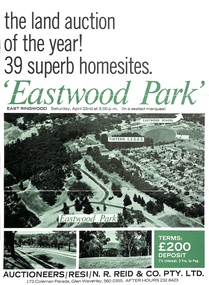 Ringwood and District Historical Society
Document - Folder, Eastwood Park Subdivision, Ringwood East, Vic. - Land Sale Circa 1967 - Site of former Eastwood/Eastfield Golf Course
Subdivision is advertised as including homesites on former Eastwood Golf Course fairways and land contours.Collection of subdivision maps, and double-sided advertisement for auction sale on Saturday, April 22nd, 1967, with summary of local features and services. Subdivision includes Croydon South streets, Andrew Crescent and Banksia Court. Agents - N.R. Reid & Co Pty Ltd, 173 Coleman Parade, Glen Waverley, Tel. 560 0355 A.H. 232 8423.Handwritten sales notations include "Vendor - Willcroft Development P/L 54-60 Southern Road Mentone Tel 93-1267 (Mrs. Morley). Lot 19 $5200, Lot 25 $4500, Lot 28 $3800, Lot 29 $3700, Lot 30 $3600. $400 deposit balance 3 yrs @ 7% $40 per month. All C/S to be prepared by vendor. 5% discount for cash." -
 Eltham District Historical Society Inc
Photograph - Digital Photograph, Alan King, Site of the Diamond Creek Gold Mine, 28 December 2007
The largest gold mine in the area originated from a find in 1862. The mine was closed January 20, 1915 when a fire destroyed nearly all the above ground plant. Published: Nillumbik Now and Then / Marguerite Marshall 2008; photographs Alan King with Marguerite Marshall.; p75 Beneath Mine Hill, as locals call it, runs a network of tunnels once of central importance to the fledgling township of Diamond Creek. These are relics of gold mines, which transformed early Diamond Creek.1 The tiny settlement of about 20 families soared to more than 200 because of gold. For around 50 years, from 1862, gold mining was Diamond Creek’s major source of employment. On September 7, 1854 The Argus newspaper reported a find of a four pound (1.8kg) gold nugget in Nillumbik (an early name for Diamond Creek). Exactly where, is not known.2 The largest mine in the district, the Diamond Creek Gold Mine, apparently originated from a find in 1862. It is said Joe and Dave Wilson were visiting former tailor then cook, Charles Orme, at the southern end of Fraser Street. Sitting on a stump outside the front gate on land belonging to Dr A. E. Phipps the Wilsons found a vein of gold-bearing quartz, which led to the discovery of four quartz reefs varying in width to eight inches (20cm), running north and south. A reef found at the foot of the hill opposite Challenger Street became the Union Mine. This reef was traced south to Allendale Road where a small mine began operations.3 Other smaller mines later operated as well. Dr Phipps immediately began to mine and also built the Diamond Reef Hotel as a boarding house for miners. But Charles Orme, who owned the land alongside, leased his mine to Dr Phipps probably because of insufficient funds and business skills. By mid 1865 the mine had produced 2530 ounces of gold – a 100% profit on the original outlay. Of course there were problems. When the local dam dried up a Blake pump was installed to draw water from the creek. The Union Mine operated under the Diamond Creek Gold Mine management except when disputes sometimes resulted in separate management. However disagreements had to be resolved as the Union Mine depended on Diamond Creek Gold Mine pumps to remove underground water from common reefs. In 1912 the main shaft of about 380 yards (350m) employed 200 men recovering an average of 5000 ounces (141.7kg) of gold a year. But not everyone did well out of gold. Records of failed mining companies in the Victorian Public Record Office, reveal that owner Dr Phipps leased his Right to others. Companies came and went over the next 40 years, most sponsored by Melbourne businessmen who sold shares to gullible locals and then became insolvent. Although there were some good profits, financial returns were haphazard until 1905. Some local residents, who were share holders in short- term companies, became well-known names in modern Diamond Creek such as Scott, Haley, Butler, Alder, Ryan, Wadeson, Reeves, Alston, Paul and Edwards. Gold mining was brought to a disastrous end on January 20, 1915 at 3 pm, when fire destroyed nearly all the above-ground plant. Fortunately no lives were lost. But reopening the mine was almost impossible because of the increasing depth of water in the main shaft. The closed mine destroyed the livelihood of 200 families and the debris took many years to clear.4 In 1946 the Diamond Creek Gold Mine was reopened by the Golden Hind Mining Company, but money ran out before the 600 feet (182.8m) or so of water could be removed. Gold remains in the mine but enormous capital would be needed to buy the land, equipment and to remove the water. Today 12 known sealed shafts along the ridge of the hills on private property extend west for around one kilometre from the corner of Fraser and Haley Streets, crossing Norma and Fyffe to Dering Streets. As recently as 1987, heavy rains revealed a former Union Mine shaft in the Georgiadis family Fyffe Street back yard.5 Allendale Mine, south of Allendale Road, is still open and one of the Union Mine’s main drives (horizontal excavation) remains unsealed, on the Creek Reserve.This collection of almost 130 photos about places and people within the Shire of Nillumbik, an urban and rural municipality in Melbourne's north, contributes to an understanding of the history of the Shire. Published in 2008 immediately prior to the Black Saturday bushfires of February 7, 2009, it documents sites that were impacted, and in some cases destroyed by the fires. It includes photographs taken especially for the publication, creating a unique time capsule representing the Shire in the early 21st century. It remains the most recent comprehenesive publication devoted to the Shire's history connecting local residents to the past. nillumbik now and then (marshall-king) collection, diamond creek, diamond creek mine, fraser street, gold mining, james cook drive, mine hill -
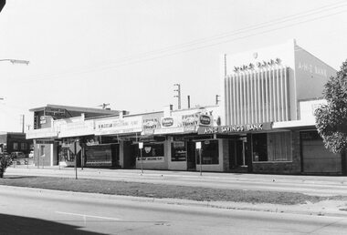 Ringwood and District Historical Society
Photograph, Maroondah Highway Central, Ringwood. Shops opposite old Town Hall site and Midway Arcade, 1969
Black and white photographShops include CBC Bank on corner of Railway Station entrance, and A.N.Z Bank at 116 Maroondah Highway. -
 Ringwood and District Historical Society
Document, Council extract stating that former tip site in Wonga Reserve (1976), used for sport, be now called Quambee Reserve (1981)
-
University of Melbourne, Burnley Campus Archives
Plan, VCAH Burnley College, Swan Street Richmond - Site Plan 1:1000 Fire Services Survey, 1991
Plan with Buildings named, External Hydrant Sources and Main Entry Points marked. Scale 1:1000. Dated January 1991.vcah, burnley, fire safety -
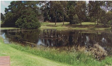 Linton and District Historical Society Inc
Photograph, Site of Former Linton Swimming Pool, Edinburgh Reserve, Linton, 2014
The photograph was taken by Gary Hunt in 2014.One of three colour photos printed on a single sheet of photographic paper. The photograph shows the section of the Edinburgh Dam which was at one time used as Linton's swimming pool. Remnants of a diving tower can be seen in the dam.edinburgh dam, swimming pool, edinburgh reserve linton -
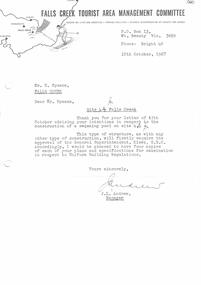 Falls Creek Historical Society
Document - Letter in response to Intention To Install Swimming Pool On Site 4
Bob (Herman) Hymans (a former member of the Royal Netherlands Navy) was born in Bloemendaal, Holland on 30th September 1922. During World War II he fought against the Japanese in the Dutch East Indies (now Indonesia) and was imprisoned in Changi and on the Burma Railway. After gaining qualifications as a Ski Instructor, Bob arrived in Falls Creek in July 1950. Working as an Instructor and Supervisor at Bogong Lodge, Bob decided his future was in accommodation. He was successful in negotiating an indenture for land from the State Electricity Commission (SEC). It took Bob two years to build his Grand Coeur Chalet but, tragically, it was burned down in August 1961. Bob also built the first Chairlift in Australia. This was a single chairlift and the structure was built from wooden electricity poles. He was constantly full of new ideas and proposals for the village. Bob Hymans died on 7th July 2007. This Collection of documents and letters tells the story of Bob's endeavours to develop Falls Creek into the ski village it is today.This item is significant because it documents proposals put forward by Bob Hymans to develop facilities in the Falls Creek Tourist Area.A response from the Management Committee informing him that approval for installation of a swimming pool requires the approval of the General Superintendent, Kiewa, SEC. The Committee therefore requests that four copies of his plans and specifications be supplied for examination.falls creek tourist area management committee, falls creek administration, bob hymans -
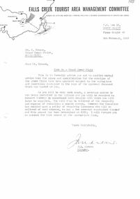 Falls Creek Historical Society
Document - Site 4a - Grand Coeur Flats Erection Approved Subject To Variations
Bob (Herman) Hymans (a former member of the Royal Netherlands Navy) was born in Bloemendaal, Holland on 30th September 1922. During World War II he fought against the Japanese in the Dutch East Indies (now Indonesia) and was imprisoned in Changi and on the Burma Railway. After gaining qualifications as a Ski Instructor, Bob arrived in Falls Creek in July 1950. Working as an Instructor and Supervisor at Bogong Lodge, Bob decided his future was in accommodation. He was successful in negotiating an indenture for land from the State Electricity Commission (SEC). It took Bob two years to build his Grand Coeur Chalet but, tragically, it was burned down in August 1961. Bob also built the first Chairlift in Australia. This was a single chairlift and the structure was built from wooden electricity poles. He was constantly full of new ideas and proposals for the village. Bob Hymans died on 7th July 2007. This Collection of documents and letters tells the story of Bob's endeavours to develop Falls Creek into the ski village it is today.This letter is significant because it reflects the relationship between Bob Hymans and the Management Committee.A letter from the Management Committee formally advising Mr Hymans that his plans and application to construct Grand Coeur Flats has been approved subject to variations enclosed. The required changes related to the installation of a sewerage in the Village. This meant that a septic tank did not have to be included in his plans, but the building must be connected to the new sewerage system and a fee paid.falls creek tourist area management committee, falls creek administration, parking regulations falls creek